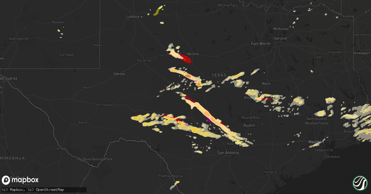
Hail Map in Texas on May 9, 2013
Get this storm
May 9 map
$229
one time, instant access
Download today. No call, no setup
Keep the $229
Bought the map and want the full workflow? Apply the entire $229 to a subscription within 7 days. None of it is wasted.
Every map, not just this one
This buys you this map. Subscription and you get every map we run, in the markets you choose from a few cities to whole states to nationwide. Plus real-time alerts the moment a storm fires.
Contact data
Name, contact info, occupancy, even credit band for addresses in the footprint. You go from where it hit to who to call.
Become the source they trust
Unlimited branding weather history reports on demand. You already have the documented answer ready for the property owner, and you are the one who showed up with it.
Property data and RoofTrace estimates
Pull up any address you have got, its value and the exact code rules for that jurisdiction, straight from One Click Code. Then RoofTrace estimates the squares, pitch, and roof value, priced the way you price.
Storm reports in Texas
Texas
| Date | Description |
|---|---|
| 05/09/20136:47 PM CDT | A local report indicates 4.50 inch wind near 5 E MENARD |
| 05/09/20136:42 PM CDT | A local report indicates 1.50 inch wind near 6 NE MENARD |
| 05/09/20136:37 PM CDT | A local report indicates 1.75 inch wind near 1 N MENARD |
| 05/09/20136:30 PM CDT | Numerous cars damaged and off the side of the road on us 83. |
| 05/09/20136:23 PM CDT | A local report indicates 1.75 inch wind near MCADOO |
| 05/09/20136:20 PM CDT | A local report indicates 1.75 inch wind near 6 NNW MENARD |
| 05/09/20136:15 PM CDT | Power lines down in trinity county |
| 05/09/20136:10 PM CDT | A local report indicates 1.50 inch wind near 2 W LIVE OAK |
| 05/09/20136:02 PM CDT | 3 to 4 inches deep of hail up to the size of golf balls. A few cars in the ditch on hwy 287 with damage to some vehicles |
| 05/09/20136:00 PM CDT | *** 1 inj *** roof blown off home and numerous trees and power lines down. Minor injury due to downed power line. |
| 05/09/20135:50 PM CDT | A local report indicates 1.75 inch wind near 6 SE VOSS |
| 05/09/20135:50 PM CDT | A local report indicates 2.75 inch wind near GOULDBUSK |
| 05/09/20135:48 PM CDT | Quarter sized hail at deacon drive and rio grande |
| 05/09/20135:39 PM CDT | 4 miles north of voss on county road 503 |
| 05/09/20135:10 PM CDT | Numerous trees down across the county |
| 05/09/20134:55 PM CDT | Two utility poles... Power lines and a mesquite tree reported down in ballinger on the west side of ballinger. |
| 05/09/20134:53 PM CDT | Baseball size hail found on the ground. Time estimated by radar and previous reports. |
| 05/09/20134:51 PM CDT | A local report indicates 1.75 inch wind near NW HATCHEL |
| 05/09/20134:51 PM CDT | A local report indicates 1.75 inch wind near 3 NNE BALLINGER |
| 05/09/20134:50 PM CDT | Numerous vehicles damages. House windows broken. |
| 05/09/20134:49 PM CDT | A local report indicates 2.00 inch wind near 6 NW BALLINGER |
| 05/09/20134:49 PM CDT | A local report indicates 2.00 inch wind near 5 SW HATCHEL |
| 05/09/20134:07 PM CDT | A local report indicates 1.75 inch wind near 6 E ROBERT LEE |
| 05/09/20134:07 PM CDT | Hail covered the ground. |
| 05/09/20133:41 PM CDT | A local report indicates 1.75 inch wind near 1 E ROBERT LEE |
| 05/09/20133:29 PM CDT | A local report indicates 1.75 inch wind near 1 E ROBERT LEE |
| 05/09/20133:20 PM CDT | A local report indicates 1.00 inch wind near 8 ENE NOLAN |
| 05/09/20133:09 PM CDT | Trees damamaged by thunderstorms winds northeast of cameron...delayed report |
| 05/09/20133:01 PM CDT | A local report indicates 1.50 inch wind near 8 SE SWEETWATER |
| 05/09/20133:00 PM CDT | 1 inch hail reported in westphalia |
| 05/09/20132:57 PM CDT | A local report indicates 1.00 inch wind near SWEETWATER |
| 05/09/20132:39 PM CDT | Ne side of temple |
| 05/09/20132:39 PM CDT | A local report indicates 1.75 inch wind near SWEETWATER |
| 05/09/20132:38 PM CDT | 72 mph measured wind gust sw of temple |
| 05/09/20132:37 PM CDT | Interstate mile marker 243 |
| 05/09/20132:34 PM CDT | On the east side of temple |
| 05/09/20132:30 PM CDT | Golf ball size hail was reported from a rainfall network observer. |
| 05/09/20132:26 PM CDT | Intersection of us 84 and interstate 20 |
| 05/09/20132:18 PM CDT | In moffat |
| 05/09/201312:57 PM CDT | Golf ball sized hail in hamilton |
| 05/09/201311:56 AM CDT | Quarter sized hail northwest of hamilton...delayed report |
| 05/09/20139:00 AM CDT | A local report indicates 1.00 inch wind near BROOKESMITH |
| 05/09/20136:40 AM CDT | Mostly pea size hail |
| 05/09/20135:59 AM CDT | Pea to quarter size hail. |
| 05/09/20135:45 AM CDT | A local report indicates 1.00 inch wind near 10 W INGRAM |
| 05/09/20135:15 AM CDT | Golfball hail near garvens store |
| 05/09/201312:45 AM CDT | Report of quarter-sized hail in orange |
| 05/09/201312:02 AM CDT | Tree blown down |
| 05/08/201311:42 PM CDT | Estimated winds 50 to 60 mph |
| 05/08/201311:23 PM CDT | A local report indicates 1.00 inch wind near NEW BRAUNFELS |
| 05/08/201311:15 PM CDT | A local report indicates 1.00 inch wind near 2 NW NEW BRAUNFELS |
| 05/08/201311:15 PM CDT | Powerlines blown down |
| 05/08/201311:15 PM CDT | A local report indicates 1.00 inch wind near 3 WNW NEW BRAUNFELS |
| 05/08/201311:15 PM CDT | A local report indicates 1.00 inch wind near 2 S NEW BRAUNFELS |
| 05/08/201311:13 PM CDT | A local report indicates 1.00 inch wind near NEW BRAUNFELS |
| 05/08/201311:09 PM CDT | A local report indicates 1.00 inch wind near 3 WNW NEW BRAUNFELS |
| 05/08/201310:52 PM CDT | A local report indicates 1.00 inch wind near 3 NE FISCHER |
| 05/08/201310:35 PM CDT | A local report indicates 1.00 inch wind near 8 SW KERRVILLE |
| 05/08/201310:30 PM CDT | Hail covered ground with drifts up to 8 inches deep |
| 05/08/201310:11 PM CDT | A local report indicates 1.75 inch wind near 7 WNW BLANCO |
| 05/08/201310:03 PM CDT | A local report indicates 1.75 inch wind near 7 SSE LBJ STATE PARK |
| 05/08/20139:59 PM CDT | A local report indicates 1.00 inch wind near 1 ESE LBJ STATE PARK |
| 05/08/20139:58 PM CDT | A local report indicates 1.25 inch wind near 4 SSW HUNT |
| 05/08/20139:40 PM CDT | A local report indicates 1.00 inch wind near FREDERICKSBURG |
| 05/08/20139:39 PM CDT | Hail broke windshields and damaged paint on houses |
| 05/08/20139:31 PM CDT | A local report indicates 2.00 inch wind near FREDERICKSBURG |
| 05/08/20139:29 PM CDT | A local report indicates 3.00 inch wind near 1 NW FREDERICKSBURG |
| 05/08/20139:25 PM CDT | A local report indicates 1.75 inch wind near 6 NE FREDERICKSBURG |
| 05/08/20139:23 PM CDT | A local report indicates 1.00 inch wind near FREDERICKSBURG |
| 05/08/20139:06 PM CDT | Tree branches down |
| 05/08/20139:06 PM CDT | A local report indicates 1.75 inch wind near 10 NW FREDERICKSBURG |
| 05/08/20139:00 PM CDT | A local report indicates 1.75 inch wind near 10 SW ENCHANTED ROCK ST |
| 05/08/20138:50 PM CDT | Car windows broken out. |
| 05/08/20138:50 PM CDT | Several trees down...carport damaged |
| 05/08/20138:46 PM CDT | A local report indicates 60 MPH wind near 9 E AMARILLO |
| 05/08/20138:40 PM CDT | Debris covering rr 783. Patrol car blown off the road. |
| 05/08/20138:40 PM CDT | A local report indicates 1.75 inch wind near 8 SSW MASON |
| 05/08/20138:39 PM CDT | Baseball sized hail in cherry spring |
| 05/08/20138:32 PM CDT | A local report indicates 1.00 inch wind near WHITE RIVER LAKE |
| 05/08/20138:25 PM CDT | Rainfall network observer reported hen egg size hail and a car windshield destroyed. |
| 05/08/20138:25 PM CDT | A local report indicates 1.25 inch wind near 13 N HARPER |
| 05/08/20138:15 PM CDT | Golf ball to billiard ball size hail |
| 05/08/20138:15 PM CDT | Golf ball to billiard ball size hail |
| 05/08/20137:51 PM CDT | Half of an inch to one inch hail 4 inches deep south of lefors on highway 273. |
| 05/08/20137:50 PM CDT | A local report indicates 1.00 inch wind near 1 SW MASON |
| 05/08/20137:50 PM CDT | Delayed report. Relayed from aerostat site. |
| 05/08/20137:50 PM CDT | A local report indicates 1.00 inch wind near MENARD |
| 05/08/20137:45 PM CDT | West texas mesonet report |
| 05/08/20137:44 PM CDT | A local report indicates 1.75 inch wind near 9 W MENARD |
| 05/08/20137:43 PM CDT | A local report indicates 1.00 inch wind near 6 NNW MENARD |
| 05/08/20137:41 PM CDT | Hail started out as pea size and the storm is currently producing golf ball size hail. |
| 05/08/20137:23 PM CDT | Quarter to golf ball size hail covering the ground. |
| 05/08/20137:16 PM CDT | Golf ball to tennis ball size hail lasted approximately 5 minutes |
| 05/08/20137:15 PM CDT | Power lines damaged by thunderstorm wind gusts. |
| 05/08/20137:05 PM CDT | Fire cheif relayed report of baseball size hail on rr 2092. |
| 05/08/20137:00 PM CDT | A local report indicates 1.50 inch wind near QUANAH |
All States Impacted by Hail Map on May 9, 2013
Cities Impacted by Hail Map on May 9, 2013
- Eola, TX
- Paint Rock, TX
- Leakey, TX
- Hamilton, TX
- Hico, TX
- Theriot, LA
- Evant, TX
- Lees Summit, MO
- North Zulch, TX
- Fredericksburg, TX
- Kerrville, TX
- Clarksville, TX
- Buckholts, TX
- Cameron, TX
- Quanah, TX
- Aurora, MO
- Shepherd, TX
- Livingston, TX
- New Waverly, TX
- Cleveland, TX
- Pointblank, TX
- Coldspring, TX
- Lake Charles, LA
- Cameron, LA
- Mason, TX
- Doss, TX
- Temple, TX
- Belton, TX
- Troy, TX
- Goodrich, TX
- Gatesville, TX
- Wingate, TX
- Hext, TX
- Menard, TX
- Brady, TX
- Ozona, TX
- Sweetwater, TX
- Newton, TX
- Santa Anna, TX
- Pampa, TX
- Doole, TX
- Voss, TX
- Gouldbusk, TX
- Jasper, TX
- Kountze, TX
- Robert Lee, TX
- Bronte, TX
- San Angelo, TX
- Miles, TX
- Roby, TX
- Carnegie, OK
- Dryden, TX
- Sonora, TX
- Greenwood, MO
- Luling, TX
- Martindale, TX
- Kingsbury, TX
- Merryville, LA
- Leesville, LA
- Pitkin, LA
- Burkeville, TX
- Deridder, LA
- Bon Wier, TX
- Evans, LA
- Eden, TX
- Franklin, LA
- Lohn, TX
- Caldwell, TX
- Hagerman, NM
- Dexter, NM
- San Ygnacio, TX
- Franklinton, LA
- Spring Branch, TX
- Blanco, TX
- Fischer, TX
- Canyon Lake, TX
- Johnson City, TX
- New Braunfels, TX
- Medina, TX
- Rocksprings, TX
- Boerne, TX
- Center Point, TX
- Ingram, TX
- Comfort, TX
- Junction, TX
- Mountain Home, TX
- Hunt, TX
- Moscow, TX
- Groveton, TX
- Corrigan, TX
- Utopia, TX
- Harper, TX
- Tecumseh, OK
- Shawnee, OK
- Bellville, TX
- Paducah, TX
- Childress, TX
- Matador, TX
- Burlington, TX
- Killeen, TX
- Moody, TX
- Eddy, TX
- Reagan, TX
- McGregor, TX
- Fort Hood, TX
- Lott, TX
- Salado, TX
- Harker Heights, TX
- Nolanville, TX
- Calvert, TX
- Rosebud, TX
- Oglesby, TX
- Hearne, TX
- Bremond, TX
- Clifton, TX
- Meridian, TX
- Gibson, LA
- Comstock, TX
- Roosevelt, TX
- Silsbee, TX
- Buna, TX
- Galena Park, TX
- Missouri City, TX
- Stafford, TX
- Pasadena, TX
- Sugar Land, TX
- Houston, TX
- Saint Gabriel, LA
- Sunshine, LA
- Prairieville, LA
- Baton Rouge, LA
- Valera, TX
- Hackberry, LA
- Lake Arthur, NM
- Ralls, TX
- Powderly, TX
- Paris, TX
- Rowena, TX
- Rockdale, TX
- Kirbyville, TX
- Norton, TX
- Talpa, TX
- Ballinger, TX
- Winters, TX
- Bridge City, TX
- Orange, TX
- Vinton, LA
- Quail, TX
- London, TX
- Ravenna, TX
- Ivanhoe, TX
- Mullin, TX
- Seguin, TX
- Hillister, TX
- Woodville, TX
- Warren, TX
- Eagle Pass, TX
- El Indio, TX
- Spurger, TX
- Fred, TX
- Snyder, TX
- Sulphur, LA
- Vidor, TX
- Kansas City, MO
- Stilwell, KS
- Overland Park, KS
- Belton, MO
- Sabinal, TX
- Clarendon, TX
- Del Rio, TX
- Gracemont, OK
- Call, TX
- Rio Frio, TX
- Fort Cobb, OK
- Chillicothe, TX
- Brownwood, TX
- Roscoe, TX
- Kendalia, TX
- Hye, TX
- Stonewall, TX
- Wimberley, TX
- San Marcos, TX
- Iowa, LA
- Bell City, LA
- Marionville, MO
- Coleman, TX
- Roosevelt, OK
- Singer, LA
- Grosse Tete, LA
- Brusly, LA
- Addis, LA
- Rochelle, TX
- Priddy, TX
- Comanche, TX
- Pottsville, TX
- Gustine, TX
- Rotan, TX
- Hondo, TX
- D Hanis, TX
- Gause, TX
- Eldorado, OK
- Miami, TX
- Patterson, LA
- Berwick, LA
- Jeanerette, LA
- Morgan City, LA
- Dequincy, LA
- Roaring Springs, TX
- Grand Chenier, LA
- Lockhart, TX
- Dale, TX
- Bandera, TX
- Sylvester, TX
- Purmela, TX
- Sealy, TX
- Normangee, TX
- Pierre Part, LA
- Napoleonville, LA
- Bryan, TX
- Groves, TX
- Port Arthur, TX
- Lacassine, LA
- Nederland, TX
- Beaumont, TX
- Creole, LA
- Westlake, LA
- Port Neches, TX
- Wolfe City, TX
- Willow City, TX
- Afton, TX
- Vancourt, TX
- Greensburg, LA
- Henderson, KY
- Rockwood, TX
- Grant, OK
- Hugo, OK
- Happy, TX
- Canyon, TX
- Jonesboro, TX
- College Station, TX
- El Dorado, AR
- Bedias, TX
- Anderson, TX
- Trent, TX
- Nolan, TX
- Merkel, TX
- Lumberton, TX
- Madisonville, TX
- Lone Jack, MO
- Goldthwaite, TX
- Marquez, TX
- Grandview, MO
- Grain Valley, MO
- Bartelso, IL
- New Baden, IL
- Albers, IL
- Crockett, TX
- Mountain Park, OK
- Rosepine, LA
- Millersview, TX
- Mertzon, TX
- Roswell, NM
- Saint Amant, LA
- Starks, LA
- Hempstead, TX
- Brookshire, TX
- Waller, TX
- Honey Grove, TX
- Brookesmith, TX
- Dayton, TX
- Celeste, TX
- Greenville, TX
- Windom, TX
- Ladonia, TX
- Miami, FL
- Hialeah, FL
- Bastrop, LA
- Schriever, LA
- Labadieville, LA
- Rosenberg, TX
- Whitney, TX
- Morgan, TX
- Germantown, IL
- Crosbyton, TX
- Longville, LA
- Deweyville, TX
- Mcadoo, TX
- Palestine, TX
- Hollywood, FL
- Farmersville, TX
- Chester, TX
- Colmesneil, TX
- Artesia, NM
- Ragley, LA
- Iola, TX
- Amite, LA
- Stoutland, MO
- Leona, TX
- Midway, TX
- Crosby, TX
- Channelview, TX
- Highlands, TX
- French Settlement, LA
- Maurepas, LA
- Livingston, LA
- Denham Springs, LA
- Kentwood, LA
- Blackwell, TX
- Bangs, TX
- Uvalde, TX
- Concan, TX
- Lorenzo, TX
- Eagle Lake, TX
- Roseland, LA
- Loranger, LA
- Emmet, AR
- Bulverde, TX
- Maxwell, TX
- Milano, TX
- Kyle, TX
- Tuscola, TX
- De Kalb, TX
- Rogers, TX
- Hope, AR
- Pineville, LA
- Lecompte, LA
- Alexandria, LA
- Goodfellow Afb, TX
- Hobart, OK
- Richmond, TX
- Jones, LA
- Inola, OK
- Chouteau, OK
- Bonham, TX
- Port Allen, LA
- Plaquemine, LA
- Elgin, TX
- McDade, TX
- Sumner, TX
- Franklin, TX
- Oakhurst, TX
- Huntsville, TX
- Hockley, TX
- Frankston, TX
- Abbott, TX
- Hillsboro, TX
- Altus, OK
- Mountain View, OK
- Turkey, TX
- Burlington, CO
- Stratton, CO
- Vona, CO
- Saint Francis, KS
- Seibert, CO
- Bethune, CO
- Idalia, CO
- Kanorado, KS
- Flagler, CO
- Kit Carson, CO
- Edson, KS
- Cheyenne Wells, CO
- Goodland, KS
- Dickens, TX
- Quitaque, TX
- Lakeview, TX
- Silverton, TX
- Memphis, TX
- Wellington, TX
- Groom, TX
- Canadian, TX
- Mobeetie, TX
- Briscoe, TX
- Wheeler, TX
- Claude, TX
- Abilene, TX
- Buffalo Gap, TX
- Ovalo, TX


