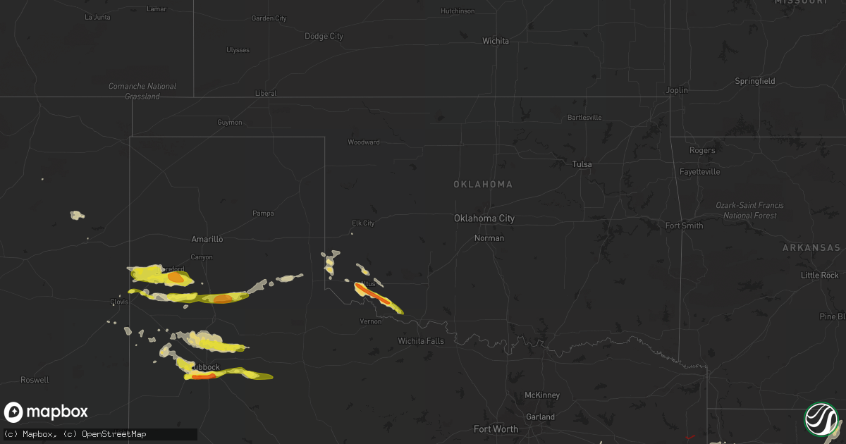
Hail Map in Oklahoma on May 8, 2019
Get this storm
May 8 map
$229
one time, instant access
Download today. No call, no setup
Keep the $229
Bought the map and want the full workflow? Apply the entire $229 to a subscription within 7 days. None of it is wasted.
Every map, not just this one
This buys you this map. Subscription and you get every map we run, in the markets you choose from a few cities to whole states to nationwide. Plus real-time alerts the moment a storm fires.
Contact data
Name, contact info, occupancy, even credit band for addresses in the footprint. You go from where it hit to who to call.
Become the source they trust
Unlimited branding weather history reports on demand. You already have the documented answer ready for the property owner, and you are the one who showed up with it.
Property data and RoofTrace estimates
Pull up any address you have got, its value and the exact code rules for that jurisdiction, straight from One Click Code. Then RoofTrace estimates the squares, pitch, and roof value, priced the way you price.
Storm reports in Oklahoma
Oklahoma
| Date | Description |
|---|---|
| 05/08/20197:25 AM CDT | At 1225 AM CDT, severe thunderstorms were located along a line extending from 10 miles southwest of Delhi to 3 miles northeast of Dodson, moving northeast at 30 mph. HAZARD...60 mph wind gusts and quarter size hail. SOURCE...Radar indicated. IMPACT...Hail damage to vehicles is expected. Expect wind damage to roofs, siding, and trees. Locations impacted include... Elk City, Sayre, Erick, Carter, Willow, Texola, Delhi, Vinson, Madge, McKnight and Brinkman. |
| 05/08/20197:13 AM CDT | At 1213 AM CDT, a severe thunderstorm was located 6 miles west of Tom Steed Reservoir, moving northeast at 35 mph. HAZARD...60 mph wind gusts and quarter size hail. SOURCE...Radar indicated. IMPACT...Hail damage to vehicles is expected. Expect wind damage to roofs, siding, and trees. Locations impacted include... Mountain View, Roosevelt, Gotebo, Cooperton, Tom Steed Reservoir and Warren. |
| 05/08/20197:11 AM CDT | At 1211 AM CDT, a severe thunderstorm was located 3 miles southeast of Burns Flat, moving northeast at 30 mph. HAZARD...60 mph wind gusts and quarter size hail. SOURCE...Radar indicated. IMPACT...Hail damage to vehicles is expected. Expect wind damage to roofs, siding, and trees. Locations impacted include... Clinton, Cordell, Burns Flat, Arapaho, Dill City, Corn, Bessie and Foss. |
| 05/08/20193:59 AM CDT | At 858 PM CDT, a severe thunderstorm was located 5 miles south of Humphreys, moving southeast at 25 mph. HAZARD...Golf ball size hail and 60 mph wind gusts. SOURCE...Radar indicated. Trained spotters reported golf ball size hail in Jackson County. IMPACT...People and animals outdoors will be injured. Expect hail damage to roofs, siding, windows, and vehicles. Expect wind damage to roofs, siding, and trees. Locations impacted include... Frederick, Tipton, Manitou, Hollister and Loveland. |
| 05/08/201912:59 AM CDT | At 559 PM CDT, a severe thunderstorm was located 9 miles north of Vinson, moving southeast at 15 mph. HAZARD...60 mph wind gusts and quarter size hail. SOURCE...Radar indicated. IMPACT...Hail damage to vehicles is expected. Expect wind damage to roofs, siding, and trees. Locations impacted include... Willow and Brinkman. |
| 05/07/20199:49 PM CDT | A local report indicates 1.00 inch wind near HOLLISTER |
| 05/07/20199:42 PM CDT | At 242 AM CDT, a severe thunderstorm was located 4 miles southwest of Cogar, moving northeast at 25 mph. HAZARD...Quarter size hail. SOURCE...Radar indicated. IMPACT...Damage to vehicles is expected. Locations impacted include... El Reno, Union City, Minco, Gracemont and Cogar. |
| 05/07/20199:33 PM CDT | A local report indicates 1.50 inch wind near FREDERICK |
| 05/07/20199:30 PM CDT | Time estimate from radar |
| 05/07/20198:55 PM CDT | At 154 AM CDT, a severe thunderstorm was located 4 miles northeast of Carnegie, moving northeast at 25 mph. HAZARD...Two inch hail and 60 mph wind gusts. SOURCE...Trained weather spotters reported two inch diameter hail in Carnegie. IMPACT...People and animals outdoors will be injured. Expect hail damage to roofs, siding, windows, and vehicles. Expect wind damage to roofs, siding, and trees. Locations impacted include... Anadarko, Carnegie, Binger, Fort Cobb, Gracemont, Lookeba, Fort Cobb Reservoir, Alfalfa, Albert and Lake Chickasha. |
| 05/07/20198:33 PM CDT | At 132 AM CDT, severe thunderstorms were located along a line extending from 4 miles southwest of Dodson to Spur, moving east at 30 mph. HAZARD...Ping pong ball size hail and 60 mph wind gusts. SOURCE...Radar indicated. IMPACT...People and animals outdoors will be injured. Expect hail damage to roofs, siding, windows, and vehicles. Expect wind damage to roofs, siding, and trees. Locations impacted include... Childress, Spur, Paducah, Matador, Dickens, Guthrie, Cee Vee, Kirkland, Afton, Swearingen, Grow, Dumont, Tell, Finney, Northfield, Delwin, Chalk, Mcadoo, Roaring Springs and Estelline. |
| 05/07/20198:29 PM CDT | A local report indicates 1.75 inch wind near 2 N OLUSTEE |
| 05/07/20198:07 PM CDT | At 106 AM CDT, a severe thunderstorm was located 6 miles north of Cooperton, moving northeast at 25 mph. HAZARD...Golf ball size hail and 60 mph wind gusts. SOURCE...Radar indicated. Storm spotters reported golf ball size hail north of Cooperton. IMPACT...People and animals outdoors will be injured. Expect hail damage to roofs, siding, windows, and vehicles. Expect wind damage to roofs, siding, and trees. Locations impacted include... Carnegie, Mountain View, Fort Cobb, Cooperton, Fort Cobb Reservoir and Alfalfa. |
All States Impacted by Hail Map on May 8, 2019
Cities Impacted by Hail Map on May 8, 2019
- Abernathy, TX
- Wolfforth, TX
- Lubbock, TX
- Ropesville, TX
- Slaton, TX
- McGregor, TX
- Dimmitt, TX
- Greenville, MS
- Leland, MS
- Marble Falls, TX
- Johnson City, TX
- Horseshoe Bay, TX
- Llano, TX
- Round Mountain, TX
- Harper, TX
- Junction, TX
- Wagon Mound, NM
- Woodville, TX
- Tucumcari, NM
- Sonora, TX
- Hollis, OK
- Gould, OK
- Littlefield, TX
- Levelland, TX
- Elmer, OK
- Altus, OK
- Elm Grove, LA
- Mosquero, NM
- Conchas Dam, NM
- Shallowater, TX
- Smyer, TX
- Tipton, OK
- Greenwood, LA
- Shreveport, LA
- Silverton, TX
- Kress, TX
- Tulia, TX
- Dodson, LA
- Winnfield, LA
- Lampasas, TX
- Lometa, TX
- Crosbyton, TX
- Ralls, TX
- Slaughter, LA
- Ethel, LA
- Zachary, LA
- Valley Spring, TX
- Menard, TX
- London, TX
- Dry Prong, LA
- Ozona, TX
- Lohn, TX
- Richland Springs, TX
- Rochelle, TX
- San Saba, TX
- Melvin, TX
- Goldthwaite, TX
- Brady, TX
- Childress, TX
- Friona, TX
- Nazareth, TX
- Hart, TX
- Lena, LA
- Cloutierville, LA
- Cherokee, TX
- Spur, TX
- Columbia, LA
- Sterlington, LA
- Rayville, LA
- Mangham, LA
- Wiergate, TX
- Monroe, LA
- West Monroe, LA
- Center Point, TX
- Kerrville, TX
- Comfort, TX
- Farwell, TX
- San Angelo, TX
- Bonifay, FL
- Coupland, TX
- Taylor, TX
- Mason, TX
- Hext, TX
- Caldwell, TX
- Olustee, OK
- Sayre, OK
- Waskom, TX
- Marshall, TX
- Duke, OK
- Fredericksburg, TX
- Van, TX
- Grand Saline, TX
- Hereford, TX
- Broadview, NM
- Summerfield, TX
- Happy, TX
- Eldorado, OK
- Frederick, OK
- Hollister, OK
- Florien, LA
- Vinson, OK
- Idalou, TX
- Petersburg, TX
- Floydada, TX
- Lorenzo, TX
- Anton, TX
- Hale Center, TX
- Eldorado, TX
- Burnet, TX
- Eros, LA
- Bastrop, LA
- Farmerville, LA
- Sedona, AZ
- Rockdale, TX
- Milano, TX
- Boerne, TX
- Blanco, TX
- Lakeview, TX
- Memphis, TX
- Paint Rock, TX
- Hico, TX
- Brookeland, TX
- Bovina, TX
- Headrick, OK
- Reagan, TX
- Sibley, LA
- Dubberly, LA
- Bienville, LA
- Heflin, LA
- Jamestown, LA
- Ringgold, LA
- Gibsland, LA
- Christoval, TX
- Rogers, NM
- Eden, TX
- Millersview, TX
- Del Rio, TX
- Mangum, OK
- Willow, OK
- Mount Enterprise, TX
- Henderson, TX
- Broaddus, TX
- Burkeville, TX
- Crockett, TX
- Centerville, TX
- Cameron, TX
- Gause, TX
- Morton, TX
- Oglesby, TX
- Many, LA
- Blair, OK
- Franklin, TX
- Buckholts, TX
- Davilla, TX
- Winnsboro, LA
- Gilbert, LA
- Jena, LA
- Enochs, TX
- Sudan, TX
- Baton Rouge, LA
- Clinton, LA
- Pride, LA
- Baker, LA
- San Augustine, TX
- Spring Branch, TX
- Fischer, TX
- Canyon Lake, TX
- Kendalia, TX
- Lexington, TX
- Whitney, TX
- Bethany, LA
- Calvert, TX
- Trinity, TX
- Amherst, TX
- Iredell, TX
- Colmesneil, TX
- Clovis, NM
- Mullin, TX
- Lott, TX
- Robeline, LA
- Fredonia, TX
- Doss, TX
- Bronson, TX
- Iola, TX
- Texico, NM
- Muleshoe, TX
- Jasper, TX
- Mooringsport, LA
- Stonewall, LA
- Barksdale Afb, LA
- Keithville, LA
- De Berry, TX
- Bossier City, LA
- Hornbeck, LA
- Chester, TX
- Moody, TX
- Thorndale, TX
- Mountain Home, TX
- Trout, LA
- Colfax, LA
- Gatesville, TX
- Paige, TX
- Cedar Creek, TX
- Art, TX
- Bergheim, TX
- Quitaque, TX
- Clarendon, TX
- Burlington, TX
- Pollok, TX
- Wells, TX
- Covington, TX
- Pineland, TX
- Doyline, LA
- Portales, NM
- Hearne, TX
- Stonewall, TX
- Willow City, TX
- Cushing, TX
- Douglass, TX
- Haughton, LA
- Natchitoches, LA
- Bedias, TX
- Somerville, TX
- Zwolle, LA
- Leesville, LA
- Boyce, LA
- Hemphill, TX
- Meridian, TX
- Newton, TX
- Wellington, TX
- Longview, TX
- White Oak, TX
- Karnack, TX
- Loveland, OK
- Snyder, TX


