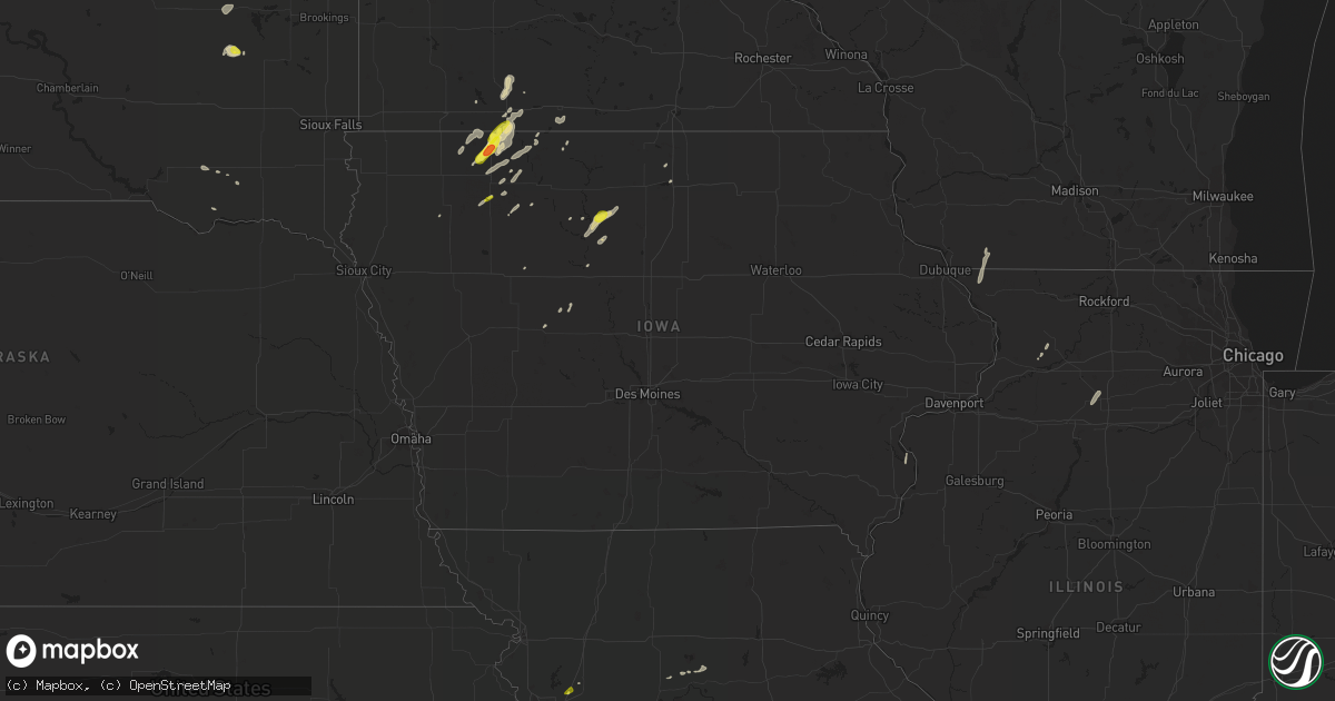
Hail Map in Iowa on May 8, 2018
Get this storm
May 8 map
$229
one time, instant access
Download today. No call, no setup
Keep the $229
Bought the map and want the full workflow? Apply the entire $229 to a subscription within 7 days. None of it is wasted.
Every map, not just this one
This buys you this map. Subscription and you get every map we run, in the markets you choose from a few cities to whole states to nationwide. Plus real-time alerts the moment a storm fires.
Contact data
Name, contact info, occupancy, even credit band for addresses in the footprint. You go from where it hit to who to call.
Become the source they trust
Unlimited branding weather history reports on demand. You already have the documented answer ready for the property owner, and you are the one who showed up with it.
Property data and RoofTrace estimates
Pull up any address you have got, its value and the exact code rules for that jurisdiction, straight from One Click Code. Then RoofTrace estimates the squares, pitch, and roof value, priced the way you price.
Storm reports in Iowa
Iowa
| Date | Description |
|---|---|
| 05/08/20183:58 AM CDT | At 857 PM CDT, a severe thunderstorm was located near Superior, or 7 miles south of Jackson In Jackson County, moving northeast at 20 mph. HAZARD...60 mph wind gusts and half dollar size hail. SOURCE...Radar indicated. IMPACT...Hail damage to vehicles is expected. Expect wind damage to roofs, siding, and trees. This severe thunderstorm will be near... Jackson In Jackson County around 920 PM CDT.Other locations impacted by this severe thunderstorm include Alpha. |
| 05/08/20183:14 AM CDT | At 814 PM CDT, severe thunderstorms were located along a line extending from near Orleans to near Milford, moving northeast at 40 mph. HAZARD...60 mph wind gusts and half dollar size hail. SOURCE...Radar indicated. IMPACT...Hail damage to vehicles is expected. Expect wind damage to roofs, siding, and trees. Severe thunderstorms will be near... Jackson In Jackson County and Orleans around 835 PM CDT. Superior around 840 PM CDT.Other locations impacted by these severe thunderstorms include Alpha. |
| 05/07/201810:45 PM CDT | Relayed by media. |
| 05/07/20188:53 PM CDT | Report via mping. |
| 05/07/20188:21 PM CDT | A local report indicates 1.75 inch wind near MILFORD |
All States Impacted by Hail Map on May 8, 2018
Cities Impacted by Hail Map on May 8, 2018
- Spirit Lake, IA
- Lakefield, MN
- Lake Park, IA
- Carthage, SD
- Fedora, SD
- Howard, SD
- Milford, IA
- Okoboji, IA
- Windom, MN
- Bingham Lake, MN
- Jackson, MN
- Mountain Lake, MN
- Waubay, SD
- Groton, SD
- Brentford, SD
- Mellette, SD
- Stratford, SD
- Conde, SD
- Andover, SD
- Terril, IA
- Arnolds Park, IA
- Belle Fourche, SD
- Jolley, IA
- Cohagen, MT
- Jordan, MT
- Fort Dodge, IA
- Sterling, IL
- Triplett, MO
- Eagle Grove, IA
- Thor, IA
- Humboldt, IA
- Hardy, IA
- Orient, SD
- Clark, SD
- Oakville, IA
- Malta, MT
- Raymond, SD
- Spencer, IA
- Dickens, IA
- Ismay, MT
- Fallon, MT
- Terry, MT
- Webster, SD
- Bristol, SD
- Livermore, IA
- Renwick, IA
- Corwith, IA
- Culver, OR
- Ruthven, IA
- Seneca, SD
- Estherville, IA
- Clinton, MN
- Ortonville, MN
- Custer, MT
- Bradley, SD
- Tripp, SD
- Fairmount, ND
- Hankinson, ND
- Redfield, SD
- Galena, IL
- Scales Mound, IL
- Shullsburg, WI
- Willow Lake, SD
- Bosworth, MO
- Doland, SD
- Glidden, IA
- Scranton, IA
- Hermitage, MO
- Trimont, MN
- Iroquois, SD
- De Smet, SD
- Milledgeville, IL
- Polo, IL
- Armstrong, IA
- Florence, SD
- Gowrie, IA
- Paton, IA
- Alzada, MT
- Marathon, IA
- Warsaw, MO
- Ottosen, IA
- Brunswick, MO
- Mendon, MO
- Lohrville, IA
- Churdan, IA
- Warner, SD
- Huron, SD
- Tyndall, SD
- Paullina, IA
- Kearney, MO
- Scotland, SD
- La Moille, IL
- Sublette, IL
- Mendota, IL
- Curlew, IA
- Lu Verne, IA
- Weaubleau, MO
- Fertile, IA
- Clear Lake, IA
- Hanlontown, IA
- Ortley, SD
- Okabena, MN
- Ocheyedan, IA
- Kansas City, MO
- Harris, IA
- Fairmont, MN
- Ceylon, MN
- Linn Grove, IA
- Sioux Rapids, IA
- Superior, IA
- Everly, IA
- Alpha, MN
- Sherburn, MN
- Laurens, IA
- Webb, IA
- Ayrshire, IA
- Corona, SD
- Miller, SD
- Bode, IA
- Greenville, IA
- Osceola, MO
- Dolliver, IA
- Swea City, IA
- Royal, IA
- Holt, MO


