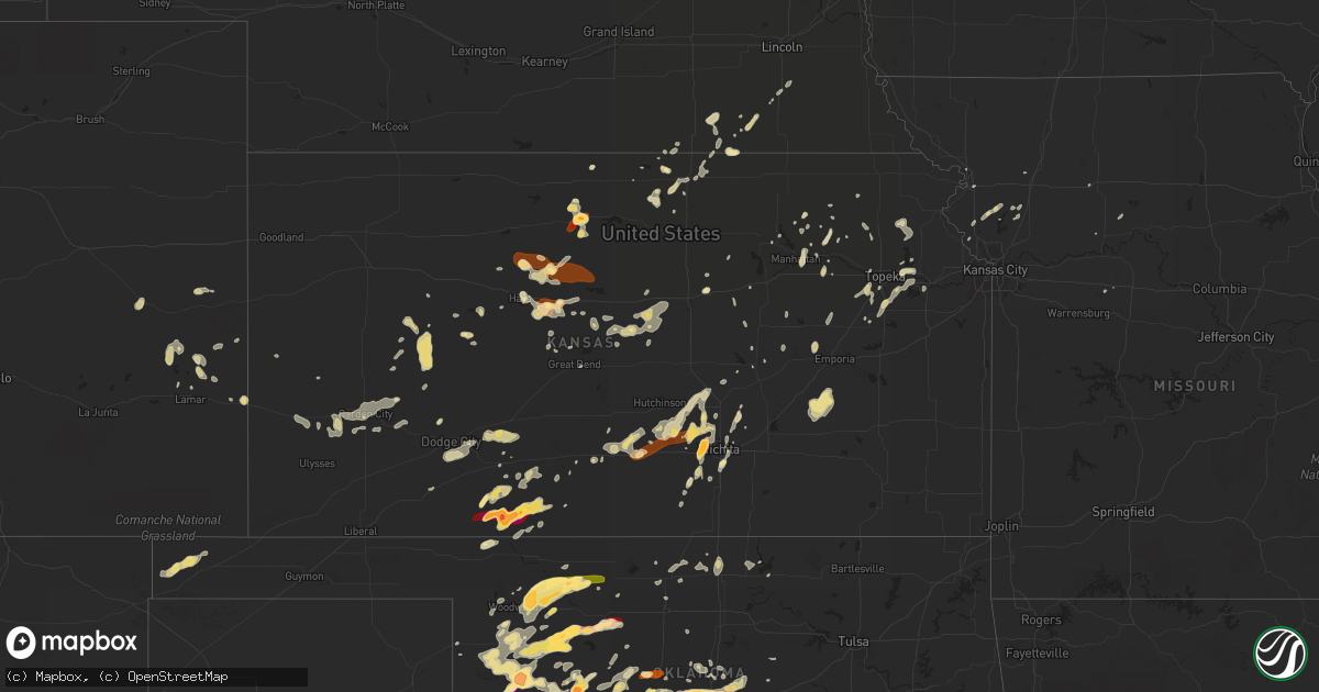
Hail Map in Kansas on May 8, 2013
Get this storm
May 8 map
$229
one time, instant access
Download today. No call, no setup
Keep the $229
Bought the map and want the full workflow? Apply the entire $229 to a subscription within 7 days. None of it is wasted.
Every map, not just this one
This buys you this map. Subscription and you get every map we run, in the markets you choose from a few cities to whole states to nationwide. Plus real-time alerts the moment a storm fires.
Contact data
Name, contact info, occupancy, even credit band for addresses in the footprint. You go from where it hit to who to call.
Become the source they trust
Unlimited branding weather history reports on demand. You already have the documented answer ready for the property owner, and you are the one who showed up with it.
Property data and RoofTrace estimates
Pull up any address you have got, its value and the exact code rules for that jurisdiction, straight from One Click Code. Then RoofTrace estimates the squares, pitch, and roof value, priced the way you price.
Storm reports in Kansas
Kansas
| Date | Description |
|---|---|
| 05/08/20136:58 PM CDT | A local report indicates 1.75 inch wind near 3 NNE BUTTERMILK |
| 05/08/20136:57 PM CDT | A local report indicates 70 MPH wind near GARDEN CITY |
| 05/08/20136:54 PM CDT | Wind gust recorded at garden city airport. |
| 05/08/20136:53 PM CDT | A local report indicates 74 MPH wind near 5 E MODOC |
| 05/08/20136:52 PM CDT | A local report indicates 1.50 inch wind near 2 ENE BUTTERMILK |
| 05/08/20136:52 PM CDT | A local report indicates 1.50 inch wind near 3 NNE BUTTERMILK |
| 05/08/20136:50 PM CDT | Several mobile homes near 950 north jenny barker road lost roofs and had siding blown off. Power poles were blown down for about a mile along highway 156 south of farml |
| 05/08/20136:45 PM CDT | Winds estimated at 60 mph blew down tree branches two to three inches in diameter near garden city community college. |
| 05/08/20136:41 PM CDT | A local report indicates 60 MPH wind near GARDEN CITY |
| 05/08/20136:40 PM CDT | An irrigation pipe was blow across highway 83. |
| 05/08/20136:40 PM CDT | A local report indicates 2.00 inch wind near 5 NW BUTTERMILK |
| 05/08/20136:39 PM CDT | A rope tornado reported which was the merger of two funnel clouds by russell county emergency manager. |
| 05/08/20136:35 PM CDT | A strong east wind destroyed a shed. |
| 05/08/20136:35 PM CDT | A local report indicates 60 MPH wind near 5 S GARDEN CITY |
| 05/08/20136:35 PM CDT | A local report indicates 1.00 inch wind near 5 S GARDEN CITY |
| 05/08/20136:35 PM CDT | A local report indicates 2.00 inch wind near 3 S PROTECTION |
| 05/08/20136:35 PM CDT | Power lines were blown down at mary street and farmland road. |
| 05/08/20136:30 PM CDT | Tree limbs 4 inches in diameter were blown down by the high wind. |
| 05/08/20136:27 PM CDT | A local report indicates 1.75 inch wind near PROTECTION |
| 05/08/20136:20 PM CDT | A local report indicates 2.75 inch wind near 5 SW PROTECTION |
| 05/08/20136:18 PM CDT | A local report indicates 1.00 inch wind near 3 SW PARADISE |
| 05/08/20136:14 PM CDT | A local report indicates 1.50 inch wind near 5 W PROTECTION |
| 05/08/20136:07 PM CDT | A local report indicates 1.75 inch wind near 5 W PROTECTION |
| 05/08/20136:05 PM CDT | A local report indicates 1.00 inch wind near 8 NNE HOWELL |
| 05/08/20136:00 PM CDT | Quarters to golf balls were reported. |
| 05/08/20135:50 PM CDT | Power poles were blown down by strong winds. |
| 05/08/20135:43 PM CDT | A local report indicates 1.00 inch wind near 4 W PROTECTION |
| 05/08/20135:40 PM CDT | A garage roof was blown off. |
| 05/08/20135:40 PM CDT | This report was a measured wind gust at the hickok grade school. |
| 05/08/20135:38 PM CDT | A local report indicates 1.00 inch wind near SITKA |
| 05/08/20135:36 PM CDT | A local report indicates 1.25 inch wind near 1 SSE SITKA |
| 05/08/20135:32 PM CDT | A semi was blown off the highway on the east side of ulysses. |
| 05/08/20135:30 PM CDT | A local report indicates 2.00 inch wind near SITKA |
| 05/08/20135:12 PM CDT | A local report indicates 1.00 inch wind near 3 S ASHLAND |
| 05/08/20134:40 PM CDT | A local report indicates 72 MPH wind near 2 E COOLIDGE |
| 05/08/20134:28 PM CDT | A local report indicates 1.00 inch wind near 8 SE FOWLER |
| 05/07/201311:10 PM CDT | Storm chaser meaures 64 mph wind gust at mentor road and 81 highway. |
| 05/07/201310:41 PM CDT | An individual from the public called into kwch with quarter sized hail. Time was estimated with radar. |
| 05/07/201310:31 PM CDT | Intersection of 24 and green valley rd |
| 05/07/201310:31 PM CDT | A local report indicates 72 MPH wind near ELLSWORTH |
| 05/07/201310:17 PM CDT | Pea to dime size hail...wind driven |
| 05/07/20139:20 PM CDT | A local report indicates 1.00 inch wind near 5 E FORBES FIELD |
| 05/07/20139:03 PM CDT | Nickel to quarter sized hail was falling 6 south of gorham. |
| 05/07/20138:56 PM CDT | A local report indicates 58 MPH wind near 4 NNW HESSTON |
| 05/07/20138:55 PM CDT | Six power poles were snapped off along l road between 150th and 160th. |
| 05/07/20138:48 PM CDT | A local report indicates 1.00 inch wind near 5 WNW BUTTERMILK |
| 05/07/20138:38 PM CDT | Pea to quarter size hail |
| 05/07/20138:32 PM CDT | Public reported via facebook to harvey county law enforcement quarter sized hail. |
| 05/07/20138:06 PM CDT | Mcconnell airforce base measures half dollar sized hail. |
| 05/07/20138:02 PM CDT | Hail is ongoing |
| 05/07/20138:00 PM CDT | A local report indicates 65 MPH wind near 7 S DODGE CITY |
| 05/07/20137:59 PM CDT | A local report indicates 81 MPH wind near 12 SW NESS CITY |
| 05/07/20137:55 PM CDT | Picture sent via facebook with quarter sized hail in kingman. Time is estimated according to radar. |
| 05/07/20137:55 PM CDT | Half dollar to golf ball sized hail reported via espotter report. |
| 05/07/20137:53 PM CDT | A local report indicates 1.00 inch wind near 2 N COLDWATER |
| 05/07/20137:51 PM CDT | Public reported ping pong to golf ball sized hail at 135th and 13th in west wichita. Time is estimated according to radar. |
| 05/07/20137:50 PM CDT | Ping pong ball hail reported by a spotter at 167th and maple. |
| 05/07/20137:49 PM CDT | A local report indicates 1.75 inch wind near 3 S MAIZE |
| 05/07/20137:48 PM CDT | Ping-pong to golfball-sized hail reported at maple/maize intersection. |
| 05/07/20137:48 PM CDT | Wind gust reported at dodge city airport. |
| 05/07/20137:45 PM CDT | Hail up to the size of quarters fell on the northeast side of hays. |
| 05/07/20137:43 PM CDT | A local report indicates 1.00 inch wind near 8 NW WILMORE |
| 05/07/20137:43 PM CDT | A tree was reported down within city limits of kingman according to dispatch. Time is estimated according to radar. |
| 05/07/20137:18 PM CDT | Citizen reported golfball to baseball hail to law enforcement. |
| 05/07/20137:18 PM CDT | Citizen reported golfball to baseball hail to law enforcement. |
All States Impacted by Hail Map on May 8, 2013
Cities Impacted by Hail Map on May 8, 2013
- Holly, CO
- Fairbury, NE
- Morrowville, KS
- Bosworth, MO
- Childress, TX
- Paducah, TX
- Duncan, OK
- Hamlin, TX
- Rotan, TX
- Norway, KS
- Scandia, KS
- Partridge, KS
- Kingman, KS
- Turon, KS
- Cunningham, KS
- Arlington, KS
- Coldwater, KS
- Maud, OK
- Holdenville, OK
- Wewoka, OK
- Wright, KS
- Fort Cobb, OK
- Gracemont, OK
- Bazine, KS
- Eads, CO
- McCaulley, TX
- Abilene, TX
- Snyder, TX
- Stamford, TX
- Lueders, TX
- Anson, TX
- Ness City, KS
- Dodge City, KS
- Republic, KS
- Goddard, KS
- Wichita, KS
- Seiling, OK
- Chester, OK
- Memphis, TX
- Dighton, KS
- Watonga, OK
- Waynoka, OK
- Alva, OK
- Wellington, TX
- Shamrock, TX
- Oklahoma City, OK
- Norman, OK
- Newcastle, OK
- Wamego, KS
- Alma, KS
- Arnett, OK
- Minneola, KS
- Dickens, TX
- Spur, TX
- Old Glory, TX
- Aspermont, TX
- Thomas, OK
- Colwich, KS
- Maize, KS
- Clearwater, KS
- Paint Rock, TX
- Eden, TX
- Millersview, TX
- Carbondale, KS
- Jansen, NE
- Plymouth, NE
- Mooreland, OK
- Hays, KS
- Victoria, KS
- Gorham, KS
- Pfeifer, KS
- Russell, KS
- Okarche, OK
- Berryton, KS
- Protection, KS
- Paradise, KS
- Council Grove, KS
- White City, KS
- Blanchard, OK
- Tuttle, OK
- Sharon, OK
- Jetmore, KS
- Matador, TX
- Grenville, NM
- Clayton, NM
- Taloga, OK
- Kingfisher, OK
- Halstead, KS
- Hesston, KS
- Mobeetie, TX
- Briscoe, TX
- Wheeler, TX
- Solomon, KS
- Voss, TX
- Buffalo, OK
- El Reno, OK
- Calumet, OK
- Osborne, KS
- Portis, KS
- Eureka, KS
- Madison, KS
- Hamilton, KS
- Sheridan Lake, CO
- Asher, OK
- Comanche, OK
- Edmond, OK
- Perry, KS
- East Greenville, PA
- Pennsburg, PA
- Burrton, KS
- Fay, OK
- Oakwood, OK
- Custer City, OK
- Anadarko, OK
- Geary, OK
- Pocasset, OK
- Lawton, OK
- Carnegie, OK
- Apache, OK
- Minco, OK
- Wheatland, OK
- Washington, OK
- Amber, OK
- Mustang, OK
- Bushton, KS
- Lorraine, KS
- Marlow, OK
- Walters, OK
- Binger, OK
- Sun City, KS
- Coats, KS
- Lookeba, OK
- Hinton, OK
- Kutztown, PA
- Fleetwood, PA
- Guthrie, OK
- Coyle, OK
- Lamar, CO
- Tecumseh, KS
- Grantville, KS
- Graham, NC
- Haw River, NC
- Cuba, KS
- Belleville, KS
- Gaylord, KS
- Alton, KS
- Utica, KS
- Beeler, KS
- Mulhall, OK
- Sweet Springs, MO
- Duncannon, PA
- Hydro, OK
- Olsburg, KS
- Arcadia, OK
- Piedmont, OK
- Cashion, OK
- Byron, NE
- Deshler, NE
- Arapaho, OK
- Haven, KS
- Moundridge, KS
- Mount Hope, KS
- Pretty Prairie, KS
- Alexandria, NE
- Argonia, KS
- Conway Springs, KS
- Stroud, OK
- Chandler, OK
- Fairview, OK
- Mutual, OK
- Freedom, OK
- Ingalls, KS
- Miles, TX
- Kanopolis, KS
- Brookville, KS
- Ellsworth, KS
- Clayton, IL
- Mullinville, KS
- Saint Helena, NE
- Newport, PA
- Halifax, PA
- Deer Creek, OK
- Lamont, OK
- Emporia, KS
- Manhattan, KS
- Middletown, PA
- Hershey, PA
- Hummelstown, PA
- Elizabethtown, PA
- Kit Carson, CO
- New Cambria, KS
- Tonkawa, OK
- Blackwell, OK
- Garden City, KS
- Haysville, KS
- Derby, KS
- Ellis, KS
- Quinter, KS
- Vici, OK
- Lincolnville, KS
- Marion, KS
- Leedey, OK
- Plainville, KS
- Hurley, SD
- Woodward, OK
- Fort Supply, OK
- Whitewater, KS
- Valley Center, KS
- Dacoma, OK
- Carmen, OK
- Aline, OK
- Peck, KS
- Reynolds, NE
- Holton, KS
- Valley Falls, KS
- Americus, KS
- Strong City, KS
- Catharine, KS
- Natoma, KS
- Holcomb, KS
- Lincoln, KS
- Pond Creek, OK
- Ashland, KS
- Crescent, OK
- Saint Joseph, MO
- Jewell, KS
- Ransom, KS
- Purcell, OK
- Alex, OK
- Noble, OK
- Lebanon, KS
- Great Bend, KS
- Greenfield, OK
- Hitchcock, OK
- Kinsley, KS
- Offerle, KS
- Spearville, KS
- Concordia, KS
- Westmoreland, KS
- Emmett, KS
- Bunker Hill, KS
- Viola, KS
- Plattsburg, MO
- Gower, MO
- Camden Point, MO
- Edgerton, MO
- Dearborn, MO
- Wilmore, KS
- Haviland, KS
- Downs, KS
- Onaga, KS
- Sedgwick, KS
- Andale, KS
- Bentley, KS
- Hutchinson, KS
- Millersburg, PA
- Butler, OK
- Hammon, OK
- San Angelo, TX
- Boise City, OK
- Schwenksville, PA
- Pottstown, PA
- Gilbertsville, PA
- Isabella, OK
- Daykin, NE
- Firth, NE
- Cortland, NE
- Medford, OK
- Boyertown, PA
- Oley, PA
- Saint George, KS
- Wellston, OK
- Luther, OK
- Meridian, OK
- Longford, KS
- Cement, OK
- Ford, KS
- Newton, KS
- Hillsboro, KS
- Fowler, KS
- Ballinger, TX
- Rowena, TX
- Baltimore, MD
- Halethorpe, MD
- Carney, OK
- Perkins, OK
- Courtland, KS
- Quail, TX
- Maysville, MO
- Cameron, MO
- Kenton, OK
- Lakin, KS
- Mereta, TX
- Eola, TX
- Cheyenne Wells, CO
- De Witt, NE
- Pickrell, NE
- Lawrence, KS
- Lecompton, KS
- Scranton, KS
- Topeka, KS
- Auburn, KS
- Wakarusa, KS
- Harveyville, KS
- Pratt, KS
- Lathrop, MO
- Elizabethville, PA
- Ponca City, OK
- Kaw City, OK
- Roby, TX
- Kendall, KS
- Holyrood, KS
- Carrollton, MO
- Meriden, KS
- Milan, KS
- Ringwood, OK
- Camargo, OK
- Randall, KS
- Lexington, OK
- Wilson, KS
- Hoisington, KS
- Claflin, KS
- Dorrance, KS
- Platte City, MO
- Enid, OK
- Kremlin, OK
- Marquette, KS
- Geneseo, KS
- Osage City, KS
- Mankato, KS
- Narka, KS
- Munden, KS
- Ryan, OK
- Warrensburg, MO
- Mebane, NC
- Chickasha, OK
- Hebron, NE
- Gilead, NE
- Clarendon, TX
- Elgin, OK
- Utica, MO
- Gove, KS
- Riley, KS
- Otis, KS
- Goff, KS
- Allen, KS
- Paxico, KS
- Ames, OK
- Fletcher, OK
- Okeene, OK
- Albert, KS
- Belvue, KS
- Mayetta, KS
- Trimble, MO
- Silver Lake, KS
- Marysville, PA
- Cushing, OK
- Weston, MO
- Wynot, NE
- Hardy, NE
- Lake City, KS
- Benton, KS
- Tribune, KS
- Lenhartsville, PA
- Greensburg, KS
- Putnam, OK
- Weatherford, OK
- Omaha, NE
- Kechi, KS
- Chapman, KS
- Wiley, CO
- Oskaloosa, KS
- Ozawkie, KS
- Verden, OK
- Mountain View, OK
- Indiahoma, OK
- Cyril, OK
- Mahaska, KS
- Burlingame, KS
- Garden Plain, KS
- Vermillion, KS
- Jamestown, KS
- Helena, OK
- Agra, OK
- Davenport, OK
- Effingham, KS
- Burbank, OK
- Abilene, KS
- Little River, KS
- Cimarron, KS
- Marshall, OK
- Nash, OK
- Healy, KS
- Viborg, SD
- Muscotah, KS
- Mcconnell Afb, KS
- Fargo, OK
- Hope, KS
- Nardin, OK
- Cherokee, OK
- Lakeview, TX
- Walker, KS
- Albany, TX
- Avoca, TX
- Cheney, KS
- Murdock, KS
- Waldo, KS
- Luray, KS
- Lucas, KS


