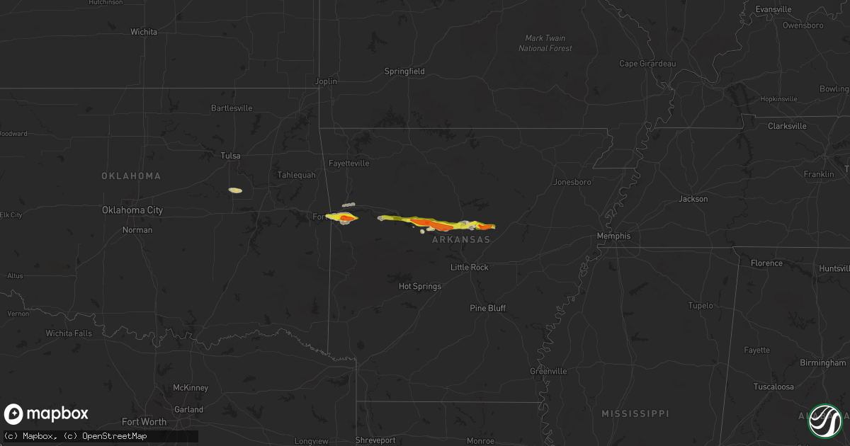
Hail Map on May 7, 2025
Get this storm
May 7 map
$229
one time, instant access
Download today. No call, no setup
Keep the $229
Bought the map and want the full workflow? Apply the entire $229 to a subscription within 7 days. None of it is wasted.
Every map, not just this one
This buys you this map. Subscription and you get every map we run, in the markets you choose from a few cities to whole states to nationwide. Plus real-time alerts the moment a storm fires.
Contact data
Name, contact info, occupancy, even credit band for addresses in the footprint. You go from where it hit to who to call.
Become the source they trust
Unlimited branding weather history reports on demand. You already have the documented answer ready for the property owner, and you are the one who showed up with it.
Property data and RoofTrace estimates
Pull up any address you have got, its value and the exact code rules for that jurisdiction, straight from One Click Code. Then RoofTrace estimates the squares, pitch, and roof value, priced the way you price.
Storm reports
Arkansas
| Date | Description |
|---|---|
| 05/07/20251:12 AM CDT | A local report indicates 1.25 inch wind near 2 SW Hart |
| 05/07/20251:10 AM CDT | A local report indicates 1.25 inch wind near 4 N Mount Vernon |
| 05/07/20251:09 AM CDT | A local report indicates 1.75 inch wind near Mount Vernon |
| 05/07/202512:41 AM CDT | A local report indicates 1.00 inch wind near 2 W Soda Valley |
| 05/06/202511:45 PM CDT | A local report indicates 1.75 inch wind near 3 WNW Economy |
| 05/06/202511:29 PM CDT | A local report indicates 1.00 inch wind near 1 NNW Russellville Regi |
| 05/06/202510:43 PM CDT | Tree fell onto a powerline. |
| 05/06/20259:32 PM CDT | A local report indicates 1.75 inch wind near Kibler |
Iowa
| Date | Description |
|---|---|
| 05/07/20255:10 PM CDT | Mesonet station rcdi4 cedar rapids i-380. |
Louisiana
| Date | Description |
|---|---|
| 05/07/202510:39 AM CDT | Broadcast media reports large tree fallen on st ferdinand st behind george washington carver high school. |
| 05/07/20259:45 AM CDT | A video filmed in the lowes parking long along manhattan boulevard in harvey showed wind gusts estimated to be 60 to 70 mph. |
| 05/07/20259:40 AM CDT | A drone video showed several power lines and fence downed by thunderstorm winds next to west jefferson medical center. Location confirmed by new orleans native nws empl |
| 05/07/20259:36 AM CDT | Asos station knew new orleans lakefront airport reports wind gust of 50 knots. |
| 05/07/20259:35 AM CDT | Thunderstorm winds knocked down a sign on the side of a commercial building along whitney avenue in terrytown. |
| 05/07/20259:30 AM CDT | Powerlines downed by thunderstorm winds in timberlane. |
| 05/07/20259:30 AM CDT | Picture of tree snapped in walnut bend neighborhood in algiers. |
| 05/07/20259:30 AM CDT | Large portion of a tree was broken off by thunderstorm winds in the timbers in algiers. |
| 05/07/20259:30 AM CDT | A video on social media showed winds estimated to be 60 to 70 mph at a home between west jefferson medical center and kings grand park. |
| 05/07/20259:30 AM CDT | Thunderstorms winds downed a tree onto a gmc yukon. |
| 05/07/20259:30 AM CDT | Picture on social media showed a large limb that snapped and bent a chain link fence in terrytown. |
| 05/07/20259:30 AM CDT | Video of very strong winds accompanied by a metal shed being destroyed as its blown from the back to the front yard along grefer avenue. |
| 05/07/20259:30 AM CDT | A flag pole was snapped on mount blanc drive in marrero. |
| 05/07/20259:27 AM CDT | Large tree limbs downed by thunderstorm winds on wall boulevard. |
| 05/07/20259:25 AM CDT | Large tree limb downed by thunderstorm winds in marrero west of barataria boulevard and south of lapalco boulevard. |
| 05/07/20259:25 AM CDT | Tree downed by thunderstorm winds in oak forest subdivision. |
| 05/07/20259:25 AM CDT | A weatherflow tempest on ferret street... A few blocks north of st charles avenue... Measured a thunderstorm wind gust of 70 mph. |
| 05/07/20259:22 AM CDT | The weatherflow mesonet station jpso-xwbk near the jefferson parish coroners office in harvey measured a thunderstorm wind gust of 60 mph. |
| 05/07/20259:21 AM CDT | Emergency manager reports trees and tree branches down on several streets in belle chasse. Time estimated by radar. |
| 05/07/20259:20 AM CDT | Broadcast media reports tree downed on rue michelle in algiers. Time estimated by radar. |
| 05/07/20259:20 AM CDT | Video showed damage to a hotel roof. |
| 05/07/20259:20 AM CDT | A picture of a powerline downed by thunderstorm winds along transcontinental drive just north of i-10. |
| 05/07/20259:20 AM CDT | Awos station knbg belle chasse reports wind gust of 51 knots. |
| 05/07/20259:12 AM CDT | Broadcast media reports wind damage including a bent traffic light pole and downed powerlines. |
| 05/07/20259:12 AM CDT | Broadcast media reports downed power lines on avenue d in marrero. |
Cities Impacted by Hail Map on May 7, 2025
- Patterson, LA
- Morgan City, LA
- Berwick, LA
- Marrero, LA
- Harvey, LA
- Gretna, LA
- Belle Chasse, LA
- Braithwaite, LA
- Violet, LA
- New Orleans, LA
- Arabi, LA
- Meraux, LA
- Chalmette, LA
- Westwego, LA
- Ama, LA
- Metairie, LA
- Kenner, LA
- Saint Rose, LA
- Slidell, LA
- Jacksonville, FL
- Atlantic Beach, FL
- Neptune Beach, FL
- Jacksonville Beach, FL
- Deland, FL
- Lake Helen, FL
- Flagler Beach, FL
- Palm Coast, FL
- Bunnell, FL
- Deltona, FL
- Ormond Beach, FL
- Beggs, OK
- Okmulgee, OK
- Morris, OK
- Keystone Heights, FL
- Florahome, FL
- Palatka, FL
- Winter Haven, FL
- Van Buren, AR
- Fort Smith, AR
- Arkoma, OK
- Roland, OK
- Muldrow, OK
- Alma, AR
- Lavaca, AR
- Barling, AR
- Rocksprings, TX
- Charleston, AR
- Paris, AR
- Scranton, AR
- Hartman, AR
- New Blaine, AR
- Subiaco, AR
- London, AR
- Knoxville, AR
- Russellville, AR
- Dover, AR
- Junction, TX
- Atkins, AR
- Pottsville, AR
- Hattieville, AR
- Solgohachia, AR
- Morrilton, AR
- Springfield, AR
- Plumerville, AR
- Greenbrier, AR
- Damascus, AR
- Quitman, AR
- Guy, AR
- Mount Vernon, AR
- Rose Bud, AR
- Romance, AR
- Enola, AR
- Rudy, AR
- Mulberry, AR
- Searcy, AR
- Lamar, AR
- Center Ridge, AR