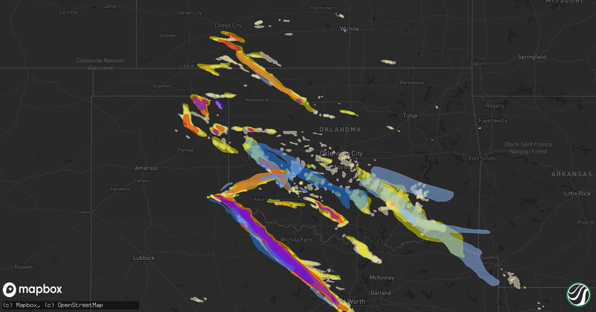
Hail Map in Oklahoma on May 7, 2020
Get this storm
May 7 map
$229
one time, instant access
Download today. No call, no setup
Keep the $229
Bought the map and want the full workflow? Apply the entire $229 to a subscription within 7 days. None of it is wasted.
Every map, not just this one
This buys you this map. Subscription and you get every map we run, in the markets you choose from a few cities to whole states to nationwide. Plus real-time alerts the moment a storm fires.
Contact data
Name, contact info, occupancy, even credit band for addresses in the footprint. You go from where it hit to who to call.
Become the source they trust
Unlimited branding weather history reports on demand. You already have the documented answer ready for the property owner, and you are the one who showed up with it.
Property data and RoofTrace estimates
Pull up any address you have got, its value and the exact code rules for that jurisdiction, straight from One Click Code. Then RoofTrace estimates the squares, pitch, and roof value, priced the way you price.
Storm reports in Oklahoma
Oklahoma
| Date | Description |
|---|---|
| 05/07/20206:37 PM CDT | Report from mping. Spotternetwork reports of 1.5 inch hail 2e of hobart. |
| 05/07/20206:34 PM CDT | Report from mping. |
| 05/07/20206:30 PM CDT | A local report indicates 1.75 inch wind near HOBART |
| 05/07/20206:24 PM CDT | Spotternetwork report. |
| 05/07/20206:20 PM CDT | A local report indicates 1.75 inch wind near 2 N GRANITE |
| 05/07/20206:20 PM CDT | Corrects previous hail report from granite. Twitter with photo. Time correction - radar estimate. |
| 05/07/20206:17 PM CDT | Spotternetwork report. |
| 05/07/20206:17 PM CDT | Twitter photo. |
| 05/07/20206:03 PM CDT | A local report indicates 3.00 inch wind near 5 SW HOLLIS |
| 05/07/20206:00 PM CDT | A local report indicates 1.75 inch wind near 11 W MANGUM |
| 05/07/20206:44 AM CDT | At 1143 PM CDT, a severe thunderstorm was located 4 miles northeast of Orlando, moving east at 55 mph. HAZARD...60 mph wind gusts and quarter size hail. SOURCE...Radar indicated. IMPACT...Hail damage to vehicles is expected. Expect wind damage to roofs, siding, and trees. Locations impacted include... Stillwater, Perry, Yale, Glencoe, Lake Carl Blackwell, Lake Mcmurtry, Quay and Ingalls. |
| 05/07/20206:25 AM CDT | At 1125 PM CDT, severe thunderstorms were located along a line extending from 5 miles northeast of Roll to near Allison Texas, moving southeast at 45 mph. HAZARD...60 mph wind gusts and quarter size hail. SOURCE...Radar indicated. IMPACT...Hail damage to vehicles is expected. Expect wind damage to roofs, siding, and trees. Locations impacted include... Elk City, Sayre, Cheyenne, Erick, Arapaho, Hammon, Canute, Butler, Reydon, Foss, Sweetwater, Strong City, Texola, Delhi, Foss Reservoir, Angora, Moorewood, Crawford, Roll and Stafford. |
| 05/07/20206:16 AM CDT | At 1116 PM CDT, severe thunderstorms were located along a line extending from 4 miles west of Watonga to 6 miles west of Kingfisher to 3 miles south of Cashion, moving east at 20 mph. HAZARD...Quarter size hail. SOURCE...Radar indicated. IMPACT...Damage to vehicles is expected. Locations impacted include... Watonga, Kingfisher, Okarche, Cashion, Greenfield, Eagle City and Omega. |
| 05/07/20206:00 AM CDT | At 1100 PM CDT, severe thunderstorms were located along a line extending from 7 miles southeast of Higgins Texas to 7 miles northwest of Reydon Oklahoma, moving east at 25 mph. HAZARD...Ping pong ball size hail and 60 mph wind gusts. SOURCE...Radar indicated. IMPACT...People and animals outdoors will be injured. Expect hail damage to roofs, siding, windows, and vehicles. Expect wind damage to roofs, siding, and trees. Locations impacted include... Reydon, Crawford and Durham. |
| 05/07/20205:40 AM CDT | At 1040 PM CDT, a severe thunderstorm was located 7 miles west of Aline, moving east-southeast at 50 mph. HAZARD...60 mph wind gusts and quarter size hail. SOURCE...Radar indicated. IMPACT...Hail damage to vehicles is expected. Expect wind damage to roofs, siding, and trees. Locations impacted include... Helena, Ringwood, Carmen, Cleo Springs, Meno and Aline. |
| 05/07/20205:39 AM CDT | At 1037 PM CDT, a severe thunderstorm was located 8 miles northwest of Angora, moving east at 30 mph. Other strong thunderstorms are developing from northwest of Angora to north of Leedey and north of Putnam that may also become severe. HAZARD...Ping pong ball size hail and 60 mph wind gusts. SOURCE...Radar indicated. IMPACT...People and animals outdoors will be injured. Expect hail damage to roofs, siding, windows, and vehicles. Expect wind damage to roofs, siding, and trees. Locations impacted include... Taloga, Thomas, Leedey, Camargo, Oakwood, Putnam, Crawford, Roll, Angora and Fay. |
| 05/07/20205:24 AM CDT | At 1024 PM CDT, a severe thunderstorm was located 9 miles west of Glazier, or 10 miles north of Canadian, moving southeast at 20 mph. HAZARD...60 mph wind gusts and quarter size hail. SOURCE...Radar indicated. IMPACT...Minor damage to roofs, siding, and trees is possible. Hail damage to vehicles is expected. Locations impacted include... Canadian, Glazier and Lake Marvin. |
| 05/07/20205:15 AM CDT | At 1015 PM CDT, a severe thunderstorm was located 8 miles northwest of Codman, or 11 miles west of Miami, moving southeast at 40 mph. HAZARD...60 mph wind gusts and quarter size hail. SOURCE...Radar indicated. IMPACT...Minor damage to roofs, siding, and trees is possible. Hail damage to vehicles is expected. Locations impacted include... Miami, Briscoe, Wheeler, New Mobeetie, Lora, Allison, Codman, Kellerville and Mobeetie. |
| 05/07/20204:47 AM CDT | At 947 PM CDT, a severe thunderstorm was located near Englewood, moving east at 40 mph. HAZARD...Quarter size hail. SOURCE...Radar indicated. IMPACT...Damage to vehicles is expected. Locations impacted include... Ashland, Englewood, Sitka and Acres. |
| 05/07/20204:25 AM CDT | At 924 PM CDT, severe thunderstorms were located along a line extending from 8 miles north of Darrouzett to near Booker to 5 miles northeast of Perryton, moving east at 45 mph. HAZARD...60 mph wind gusts and quarter size hail. SOURCE...Radar indicated. IMPACT...Minor damage to roofs, siding, and trees is possible. Hail damage to vehicles is expected. Locations impacted include... Perryton, Lipscomb, Booker, Follett, Darrouzett, Wolf Creek Park and Farnsworth. |
| 05/07/20204:19 AM CDT | At 919 PM CDT, a severe thunderstorm was located 9 miles northeast of Forgan, or 10 miles south of Meade State Park, moving east at 30 mph. HAZARD...Ping pong ball size hail. SOURCE...Radar indicated. IMPACT...People and animals outdoors will be injured. Expect damage to roofs, siding, windows, and vehicles. This severe thunderstorm will remain over mainly rural areas of southern Meade and southwestern Clark Counties. |
| 05/07/20204:07 AM CDT | At 906 PM CDT, a severe thunderstorm was located 4 miles south of Indiahoma, moving east at 30 mph. HAZARD...60 mph wind gusts and quarter size hail. SOURCE...Radar indicated. IMPACT...Hail damage to vehicles is expected. Expect wind damage to roofs, siding, and trees. Locations impacted include... Lawton, Cache, Geronimo, Indiahoma, Faxon, Fort Sill and southern Wichita Mountains Wildlife Refuge. |
| 05/07/20204:03 AM CDT | Reports of widespread power outages in the county. We have a pole snapped in half with a line down on hwy 3 east of pipe springs rd. Reports of a tree down on living la |
| 05/07/20203:57 AM CDT | Trees down in the lukfata area nw of broken bow and also in the golden area community. |
| 05/07/20203:54 AM CDT | Trees down... Power lines from broken bow to red river... Highways blocked... From mccurtain county sheriffs office. |
| 05/07/20203:54 AM CDT | Trees down south of idabel. |
| 05/07/20203:45 AM CDT | Photo of valliant high school baseball field where a large outdoor light on tall pole was broken off and splintered near the base. |
| 05/07/20203:42 AM CDT | Trees down and damage reported in valliant. |
| 05/07/20203:37 AM CDT | A local report indicates 60 MPH wind near 4 SW LEHIGH |
| 05/07/20203:26 AM CDT | Several trees down north of fort towson. Time is estimated from radar. |
| 05/07/20203:20 AM CDT | A local report indicates 63 MPH wind near 2 NW HUGO |
| 05/07/20203:20 AM CDT | Report of widespread power outages in hugo. Also reported nickel size hail. |
| 05/07/20203:18 AM CDT | Em reports barn blown down sw of gay. Time is estimated from radar. |
| 05/07/20203:14 AM CDT | Em reports several power lines and trees down. Time is estimated from radar. |
| 05/07/20203:12 AM CDT | Lots of trees down in rattan according to em. Time is estimated from radar. |
| 05/07/20203:11 AM CDT | Em reports barn blown down near speer. Time is estimated from radar. |
| 05/07/20203:09 AM CDT | Trees and power poles down in kent. Time is estimated from radar. |
| 05/07/20203:05 AM CDT | Em reports trees down on road south of antlers. Time estimated from radar. |
| 05/07/20203:04 AM CDT | Em reports roof damage to a house. Time estimated from radar. |
| 05/07/20203:03 AM CDT | Reports of a tree on a house on e 1st. Additional reports of multiple power poles down or broke. |
| 05/07/20203:02 AM CDT | Relayed through nwschat. |
| 05/07/20203:02 AM CDT | Back porch tin awning torn off... Freezer moved off porch. |
| 05/07/20203:01 AM CDT | Tree down near highway 3 according to em. Time estimated from radar. |
| 05/07/20202:57 AM CDT | Em reports trees down in darwin. Time estimated from radar. |
| 05/07/20202:57 AM CDT | Relayed through nwschat. |
| 05/07/20202:56 AM CDT | Tree limbs approximately 3 inches in diameter reported snapped by thunderstorm winds. |
| 05/07/20202:56 AM CDT | Tree down in higgins. Time estimated from radar. |
| 05/07/20202:56 AM CDT | A local report indicates 1.75 inch wind near 4 S BLANCO |
| 05/07/20202:55 AM CDT | Uprooted tree and downed tree limbs at bentley cemetery. Pictures submitted via facebook. |
| 05/07/20202:55 AM CDT | A local report indicates 75 MPH wind near 1 WNW LANE |
| 05/07/20202:54 AM CDT | Off duty pd in hartshorne reported downed power lines. Half of town without power. |
| 05/07/20202:53 AM CDT | Relayed through nwschat. |
| 05/07/20202:52 AM CDT | Report of multiple power lines down across highway 270 in bache. |
| 05/07/20202:48 AM CDT | Large tree uprooted in the southwest part of town. Time based on radar. |
| 05/07/20202:48 AM CDT | Mobile home had part of its roof removed by straight line winds... Per madille fd. Time estimated from radar. |
| 05/07/20202:46 AM CDT | Corrects previous report from atoka... Correct hazard type to hail. Also power outages in atoka with 50mph winds. |
| 05/07/20202:45 AM CDT | Several pics relayed via twitter of tree damage in mcalester. Time estimated by radar and asos wind gust measurement at kmlc. |
| 05/07/20202:45 AM CDT | Estimated 70 to 80 mph winds due to snapped main line utility poles and vhf antenna at eoc. |
| 05/07/20202:43 AM CDT | A local report indicates 64 MPH wind near MCALESTER REGIONAL AIRP |
| 05/07/20202:35 AM CDT | Roof damage... Church in town had metal roof peeled off and hanging in power lines. Power lines down and tree damage. |
| 05/07/20202:30 AM CDT | Tree limbs down... Damages to multiple roofs in town. Time estimated by radar |
| 05/07/20202:30 AM CDT | Stuart mesonet measured thunderstorm wind gust to 61 mph. |
| 05/07/20202:21 AM CDT | Relayed through nwschat. |
| 05/07/20202:20 AM CDT | A local report indicates 1.00 inch wind near DUNCAN |
| 05/07/20202:14 AM CDT | Spotternetwork report. |
| 05/07/20202:11 AM CDT | A local report indicates 1.50 inch wind near 1 WNW DUNCAN |
| 05/07/20202:09 AM CDT | Report from mping. |
| 05/07/20202:01 AM CDT | Nwschat relayed. |
| 05/07/20202:01 AM CDT | At 701 PM CDT, a severe thunderstorm was located near Mountain View, moving east at 55 mph. HAZARD...60 mph wind gusts and quarter size hail. SOURCE...Radar indicated. IMPACT...Hail damage to vehicles is expected. Expect wind damage to roofs, siding, and trees. Locations impacted include... Anadarko, Carnegie, Mountain View, Binger, Fort Cobb, Verden, Gracemont, Fort Cobb Reservoir, Cogar, Alfalfa, Albert and Lake Chickasha. |
| 05/07/20201:58 AM CDT | Spotternetwork report. |
| 05/07/20201:48 AM CDT | At 648 PM CDT, a severe thunderstorm was located 5 miles east of Quanah, moving southeast at 25 mph. This is a very dangerous storm. HAZARD...Three inch hail and 70 mph wind gusts. SOURCE...Radar indicated. IMPACT...People and animals outdoors will be severely injured. Expect shattered windows, extensive damage to roofs, siding, and vehicles. Locations impacted include... Vernon, Quanah, Chillicothe, Eldorado, Davidson, Thalia, Lockett, Medicine Mound, Fargo, Odell, Oklaunion, Grayback and Rayland. |
| 05/07/20201:45 AM CDT | A local report indicates 60 MPH wind near 4 SSW SEMINOLE |
| 05/07/20201:38 AM CDT | Downed power lines in town. Time estimated from radar. |
| 05/07/20201:35 AM CDT | Reported at highway 19 west side of bradley... Trees down on road... Twitter picture. |
| 05/07/20201:30 AM CDT | Spotternetwork measured report. |
| 05/07/20201:27 AM CDT | At 627 PM CDT, a severe thunderstorm was located near Lone Wolf, moving east at 50 mph. HAZARD...Ping pong ball size hail and 60 mph wind gusts. SOURCE...Radar indicated. IMPACT...People and animals outdoors will be injured. Expect hail damage to roofs, siding, windows, and vehicles. Expect wind damage to roofs, siding, and trees. Locations impacted include... Hobart, Cordell, Sentinel, Mountain View, Corn, Lone Wolf, Gotebo, Rocky, Colony, Cloud Chief, Cowden and northern Altus-Lugert Lake. |
| 05/07/20201:25 AM CDT | A local report indicates 60 MPH wind near CHICKASHA |
| 05/07/20201:20 AM CDT | Corrects previous report from meers. Changed hazard type to hail. |
| 05/07/20201:20 AM CDT | At 620 PM CDT, a severe thunderstorm was located 10 miles north of Goodlett, moving southeast at 20 mph. This is a very dangerous storm. HAZARD...Three inch hail and 70 mph wind gusts. SOURCE...Radar indicated. IMPACT...People and animals outdoors will be severely injured. Expect shattered windows, extensive damage to roofs, siding, and vehicles. Locations impacted include... Quanah, Chillicothe, Eldorado, Goodlett and Copper Breaks State Park. |
| 05/07/20201:16 AM CDT | A local report indicates 60 MPH wind near ANADARKO |
| 05/07/20201:14 AM CDT | Spotternetwork report. |
| 05/07/20201:01 AM CDT | A local report indicates 1.00 inch wind near MUSTANG |
| 05/07/20201:00 AM CDT | A local report indicates 62 MPH wind near 4 NNW FORT COBB |
| 05/07/202012:56 AM CDT | At 556 PM CDT, a severe thunderstorm was located 6 miles east of Vinson, moving northeast at 40 mph. HAZARD...Two inch hail and 60 mph wind gusts. SOURCE...Radar indicated. IMPACT...People and animals outdoors will be injured. Expect hail damage to roofs, siding, windows, and vehicles. Expect wind damage to roofs, siding, and trees. Locations impacted include... Mangum, Granite, Blair, Lone Wolf, Carter, Roosevelt, Martha, Willow, Retrop, Vinson, Warren, Brinkman, Hester and Altus-Lugert Lake. |
| 05/07/202012:39 AM CDT | At 539 PM CDT, a severe thunderstorm was located 8 miles south of Hollis, moving east at 35 mph. HAZARD...Golf ball size hail and 60 mph wind gusts. SOURCE...Radar indicated. IMPACT...People and animals outdoors will be injured. Expect hail damage to roofs, siding, windows, and vehicles. Expect wind damage to roofs, siding, and trees. Locations impacted include... Olustee and Eldorado. |
| 05/07/202012:21 AM CDT | At 521 PM CDT, a severe thunderstorm was located near Dodson, moving east at 55 mph. HAZARD...Ping pong ball size hail and 60 mph wind gusts. SOURCE...Radar indicated. IMPACT...People and animals outdoors will be injured. Expect hail damage to roofs, siding, windows, and vehicles. Expect wind damage to roofs, siding, and trees. Locations impacted include... Mangum, Hollis, Willow, Gould, Vinson, Duke, Brinkman, Hester, McKnight and McQueen. |
| 05/07/202012:07 AM CDT | At 506 PM CDT, a severe thunderstorm was located 12 miles southwest of Wellington, moving east at 45 mph. HAZARD...60 mph wind gusts and quarter size hail. SOURCE...Radar indicated. IMPACT...Hail damage to vehicles is expected. Expect wind damage to roofs, siding, and trees. This severe thunderstorm will remain over mainly rural areas of Childress and northeastern Hall Counties. |
| 05/06/202011:51 PM CDT | At 450 PM CDT, a severe thunderstorm was located 4 miles southeast of Memphis, moving east at 45 mph. HAZARD...60 mph wind gusts and quarter size hail. SOURCE...Radar indicated. IMPACT...Hail damage to vehicles is expected. Expect wind damage to roofs, siding, and trees. Locations impacted include... Childress, Memphis, Kirkland and Estelline. |
| 05/06/202011:19 PM CDT | A local report indicates 1.00 inch wind near 2 N AMES |
| 05/06/202010:43 PM CDT | Twitter report with photo. |
| 05/06/202010:00 PM CDT | Mesonet report. |
| 05/06/20209:43 PM CDT | A local report indicates 1.75 inch wind near 3 WNW LOOKOUT |
| 05/06/20209:18 PM CDT | A local report indicates 1.50 inch wind near 4 WSW CACHE |
| 05/06/20209:15 PM CDT | Along highway 23 north of forgan. |
| 05/06/20208:36 PM CDT | Spotternetwork report. |
| 05/06/20207:30 PM CDT | Twitter with photo. |
Cities Impacted by Hail Map on May 7, 2020
- Mcalester, OK
- Bradley, AR
- Fort Stockton, TX
- Graham, OK
- Lawton, OK
- Walters, OK
- Marlow, OK
- Wilson, OK
- Ringling, OK
- Healdton, OK
- Loco, OK
- Elgin, OK
- Lone Grove, OK
- Comanche, OK
- Duncan, OK
- Sedgwick, KS
- Mountain View, OK
- Dryden, TX
- Holliday, TX
- Windthorst, TX
- Olney, TX
- Bentley, KS
- Enid, OK
- Laverne, OK
- Follett, TX
- Davis, OK
- Sulphur, OK
- Wynnewood, OK
- Pauls Valley, OK
- Rotan, TX
- Snyder, TX
- Hermleigh, TX
- Ford, KS
- Minneola, KS
- Bristow, OK
- Weatherford, TX
- Lexington, OK
- Ashland, KS
- Hydro, OK
- Gracemont, OK
- Fort Cobb, OK
- Cordell, OK
- Binger, OK
- Lookeba, OK
- Carnegie, OK
- Canadian, TX
- Briscoe, TX
- Gould, OK
- Mangum, OK
- Vinson, OK
- Buffalo, OK
- Fort Worth, TX
- Miami, TX
- Sweetwater, OK
- Reydon, OK
- Jacksboro, TX
- Perrin, TX
- Arnett, OK
- Cache, OK
- Indiahoma, OK
- Perryton, TX
- Corn, OK
- Weatherford, OK
- Rocky, OK
- Hobart, OK
- Sentinel, OK
- Dill City, OK
- Soper, OK
- Atoka, OK
- Spencerville, OK
- Lane, OK
- Antlers, OK
- Rattan, OK
- Hugo, OK
- Marietta, OK
- Whitesboro, TX
- Gainesville, TX
- Thackerville, OK
- Dodson, TX
- Quanah, TX
- Childress, TX
- Hollis, OK
- Freedom, OK
- El Reno, OK
- Pocasset, OK
- Amber, OK
- Newcastle, OK
- Mustang, OK
- Union City, OK
- Blanchard, OK
- Tuttle, OK
- Minco, OK
- Roosevelt, OK
- Elk City, OK
- Butler, OK
- Hammon, OK
- Foss, OK
- Canute, OK
- Gotebo, OK
- Yukon, OK
- Okarche, OK
- Stringtown, OK
- Springtown, TX
- Centrahoma, OK
- Coalgate, OK
- Tupelo, OK
- Ellinwood, KS
- Hudson, KS
- Hennessey, OK
- Aline, OK
- Carmen, OK
- Watonga, OK
- Calumet, OK
- Konawa, OK
- Cedar Vale, KS
- Waynoka, OK
- Bethany, OK
- Oklahoma City, OK
- Balko, OK
- Plains, KS
- Forgan, OK
- Meade, KS
- Waukomis, OK
- Stratford, OK
- Sherman, TX
- Gunter, TX
- Collinsville, TX
- Howe, TX
- Van Alstyne, TX
- Lone Wolf, OK
- Granite, OK
- Athens, LA
- Homer, LA
- Protection, KS
- Iraan, TX
- Sheffield, TX
- Aledo, TX
- Shattuck, OK
- Anadarko, OK
- Stillwater, OK
- Purcell, OK
- Washington, OK
- Ensign, KS
- Fowler, KS
- Bridgeport, TX
- Paradise, TX
- Decatur, TX
- Pratt, KS
- Muskogee, OK
- Hartshorne, OK
- Blanco, OK
- Pittsburg, OK
- Booker, TX
- Electra, TX
- Whitt, TX
- Bryson, TX
- Jermyn, TX
- Archer City, TX
- Loving, TX
- Poolville, TX
- Seymour, TX
- Norman, OK
- Newalla, OK
- Tecumseh, OK
- Mcloud, OK
- Burleson, TX
- Azle, TX
- Scotland, TX
- Vernon, TX
- Crowell, TX
- Eldorado, OK
- Bellevue, TX
- Chillicothe, TX
- Crowley, TX
- Bowie, TX
- Henrietta, TX
- Wardville, OK
- Texarkana, AR
- Cheyenne, OK
- Joshua, TX
- Godley, TX
- Dacoma, OK
- Ringwood, OK
- Alva, OK
- Coldwater, KS
- Cleo Springs, OK
- Helena, OK
- Stinnett, TX
- Asher, OK
- Taloga, OK
- Newark, TX
- Boyd, TX
- Comstock, TX
- Minden, LA
- Ada, OK
- Tishomingo, OK
- Sasakwa, OK
- Stonewall, OK
- Allen, OK
- Calvin, OK
- Milburn, OK
- Mill Creek, OK
- Wanette, OK
- Sawyer, OK
- Fort Towson, OK
- Boswell, OK
- Hinton, OK
- Kiowa, OK
- Covington, OK
- Englewood, KS
- Bradley, OK
- Ninnekah, OK
- Alex, OK
- Chickasha, OK
- Haviland, KS
- Noble, OK
- Macomb, OK
- Leedey, OK
- Frederick, OK
- Crawford, OK
- Eros, LA
- Geary, OK
- Apache, OK
- Lewis, KS
- Kinsley, KS
- Fletcher, OK
- Willow, OK
- Spearman, TX
- Gate, OK
- Pryor, OK
- Durham, OK
- Raymond, KS
- Carrier, OK
- Lahoma, OK
- Chico, TX
- Rush Springs, OK
- Fay, OK
- Perry, OK
- Orlando, OK
- Lewisville, AR
- Macksville, KS
- Graham, TX
- Alvarado, TX
- Graford, TX
- Wellington, TX
- Naval Air Station Jrb, TX
- Mansfield, TX
- Rhome, TX
- Kingfisher, OK
- Ames, OK
- Drummond, OK
- Higgins, TX
- Maud, OK
- Wayne, OK
- Greenfield, OK
- Putnam, OK
- Elmore City, OK
- Paoli, OK
- Chase, KS
- Daisy, OK
- Stuart, OK
- Coleman, OK
- Wapanucka, OK
- Kellyville, OK
- Marshall, OK
- Custer City, OK
- Byars, OK
- Cement, OK
- Lindsay, OK
- Bison, OK
- Grant, OK
- Bushton, KS
- Faxon, OK
- Fouke, AR
- Lake City, KS
- Wilmore, KS
- Medicine Park, OK
- Cyril, OK
- Headrick, OK
- Roff, OK
- Great Bend, KS
- Greensburg, KS
- Maysville, OK
- Verden, OK
- Memphis, TX
- Spencer, OK
- Alvord, TX
- May, OK
- Burrton, KS
- Sedan, KS
- Earlsboro, OK
- Thomas, OK
- Plain Dealing, LA
- Springhill, LA
- Taylor, AR
- Garland City, AR
- Lincoln, AR
- Arthur City, TX
- Lorraine, KS
- Tioga, TX
- Burneyville, OK
- Oakwood, OK
- Iuka, KS
- Stafford, KS
- St John, KS
- Dodge City, KS
- Clinton, OK
- Holyrood, KS
- Claflin, KS
- Clayton, OK
- Bucklin, KS
- Kismet, KS
- Harrold, TX
- Cresson, TX
- Mooreland, OK
- Colony, OK
- Arapaho, OK
- Sayre, OK
- Bessie, OK
- Foster, OK
- Hennepin, OK
- Talihina, OK
- Lamar, OK
- Nashoba, OK
- Atwood, OK
- Savanna, OK
- Wilburton, OK
- Seminole, OK
- Wewoka, OK
- Haileyville, OK
- Tuskahoma, OK
- Krebs, OK
- Bowlegs, OK
- Holdenville, OK
- Albion, OK
- Doddridge, AR
- Marietta, TX
- Avery, TX
- Ringold, OK
- Simms, TX
- Rufe, OK
- Naples, TX
- Queen City, TX
- Atlanta, TX
- Garvin, OK
- Valliant, OK
- Foreman, AR
- De Queen, AR
- Idabel, OK
- Detroit, TX
- Wright City, OK
- Bloomburg, TX
- New Boston, TX
- Bagwell, TX
- Annona, TX
- Eagletown, OK
- Fitzhugh, OK
- Maud, TX
- Moyers, OK
- De Kalb, TX
- Douglassville, TX
- Clarksville, TX
- Haworth, OK
- Broken Bow, OK
- Wichita, KS
- Chattanooga, OK
- Snyder, OK
- Tipton, OK
- Montezuma, KS
- Isabella, OK
- Meno, OK
- Lucien, OK
- Bennington, OK
- Caddo, OK
- Paris, TX
- Caney, OK
- Mineral Wells, TX


