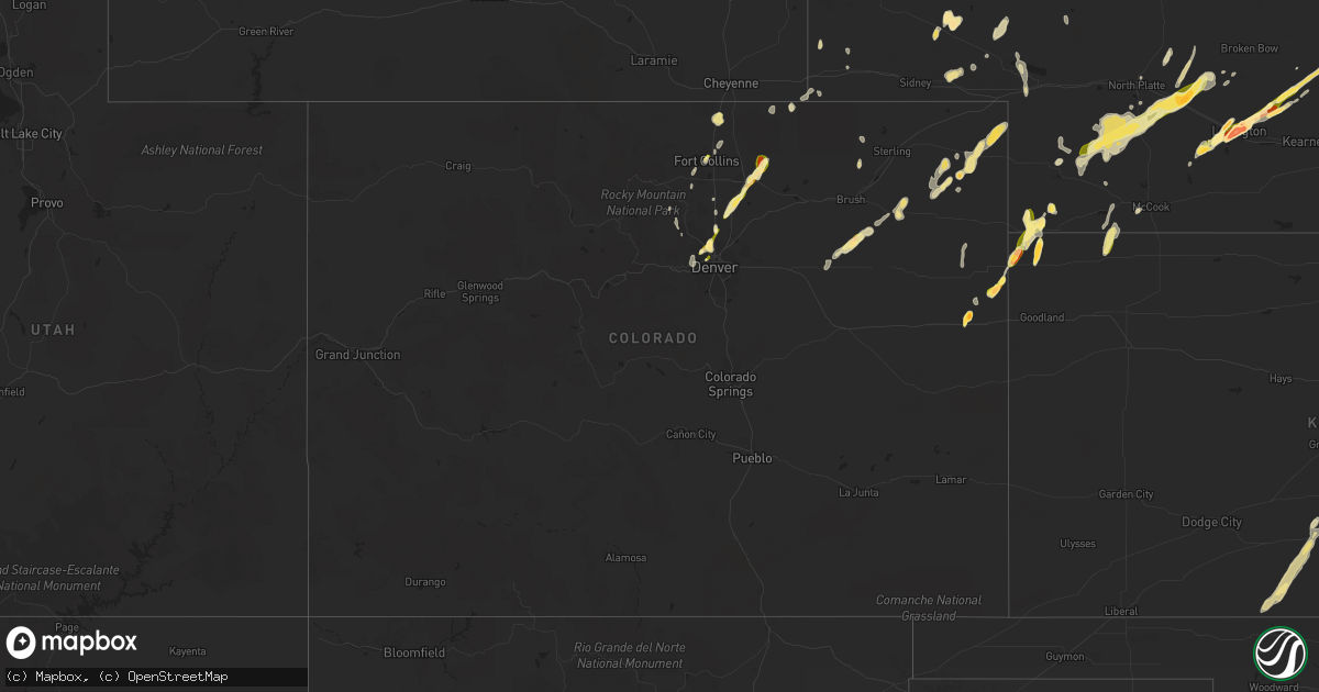
Hail Map in Colorado on May 7, 2014
Get this storm
May 7 map
$229
one time, instant access
Download today. No call, no setup
Keep the $229
Bought the map and want the full workflow? Apply the entire $229 to a subscription within 7 days. None of it is wasted.
Every map, not just this one
This buys you this map. Subscription and you get every map we run, in the markets you choose from a few cities to whole states to nationwide. Plus real-time alerts the moment a storm fires.
Contact data
Name, contact info, occupancy, even credit band for addresses in the footprint. You go from where it hit to who to call.
Become the source they trust
Unlimited branding weather history reports on demand. You already have the documented answer ready for the property owner, and you are the one who showed up with it.
Property data and RoofTrace estimates
Pull up any address you have got, its value and the exact code rules for that jurisdiction, straight from One Click Code. Then RoofTrace estimates the squares, pitch, and roof value, priced the way you price.
Storm reports in Colorado
Colorado
| Date | Description |
|---|---|
| 05/07/20146:55 PM CDT | A local report indicates 1.50 inch wind near 7 ENE CLARKVILLE |
| 05/07/20146:47 PM CDT | Ground turned white from hail. Recorded 0.40 inches rainfall. |
| 05/07/20146:35 PM CDT | A local report indicates 1.50 inch wind near SIXTEEN-MILE CORNER |
| 05/07/20146:27 PM CDT | A local report indicates 1.00 inch wind near 1 E WARD |
| 05/07/20146:25 PM CDT | A local report indicates a tornado near 3 S HAXTUN |
| 05/07/20145:30 PM CDT | A local report indicates a tornado near 1 W OTIS |
| 05/07/20145:22 PM CDT | A local report indicates a tornado near 2 SSW PLATNER |
| 05/07/20145:05 PM CDT | A local report indicates a tornado near 10 SSW OTIS |
| 05/07/20144:55 PM CDT | Greeley airport |
| 05/07/20144:50 PM CDT | A local report indicates 1.50 inch wind near 3 S VERNON |
| 05/07/20144:40 PM CDT | A few stones as large as 2.25 inches. |
| 05/07/20144:30 PM CDT | Time estimated from radar. Mostly pea size with a few golf ball size. |
| 05/07/20144:30 PM CDT | A local report indicates 1.00 inch wind near 6 S BONNY RESERVOIR |
| 05/07/20144:27 PM CDT | Hail 3 inches deep |
| 05/07/20144:25 PM CDT | Tornado track from platteville to 5s gilcrest |
| 05/07/20144:18 PM CDT | A local report indicates 1.00 inch wind near 4 S FORT COLLINS |
| 05/07/20144:07 PM CDT | A local report indicates 1.00 inch wind near 4 E PLATTEVILLE |
| 05/07/20143:45 PM CDT | A local report indicates 1.75 inch wind near 2 N BETHUNE |
| 05/07/20143:44 PM CDT | A local report indicates 1.00 inch wind near 5 NW DENVER |
| 05/07/20143:44 PM CDT | A local report indicates 1.25 inch wind near 2 ENE FORT COLLINS |
| 05/06/20149:47 PM CDT | A local report indicates 1.00 inch wind near DACONO |
| 05/06/20149:15 PM CDT | 136th and zuni |
| 05/06/20149:14 PM CDT | A local report indicates 1.00 inch wind near 1 SE THORNTON |
| 05/06/20149:14 PM CDT | A local report indicates 1.00 inch wind near BROOMFIELD |
| 05/06/20149:13 PM CDT | A local report indicates 1.00 inch wind near 3 SSW NIWOT |
| 05/06/20149:08 PM CDT | A local report indicates 1.00 inch wind near 1 SSW NORTHGLENN |
| 05/06/20148:58 PM CDT | 88th and huron |
| 05/06/20148:35 PM CDT | A local report indicates 1.00 inch wind near ARVADA |
| 05/06/20147:43 PM CDT | A local report indicates 1.00 inch wind near 4 S FORT COLLINS |
| 05/06/20147:39 PM CDT | A local report indicates 1.00 inch wind near S FORT COLLINS |
| 05/06/20147:30 PM CDT | A local report indicates 1.00 inch wind near NW LOVELAND |
| 05/06/20147:02 PM CDT | A local report indicates 1.00 inch wind near 10 ENE CLARKVILLE |
All States Impacted by Hail Map on May 7, 2014
Cities Impacted by Hail Map on May 7, 2014
- Holliday, TX
- Loveland, OK
- Iowa Park, TX
- Electra, TX
- Burkburnett, TX
- Walters, OK
- Grandfield, OK
- Chattanooga, OK
- Lakeville, MN
- Farmington, MN
- Northfield, MN
- Inver Grove Heights, MN
- Rosemount, MN
- Elko New Market, MN
- Saint Paul, MN
- Webster, MN
- Weatherford, OK
- Thomas, OK
- Custer City, OK
- Amherst, NE
- Miller, NE
- Roscommon, MI
- Saint Helen, MI
- Clyde, KS
- Clifton, KS
- Raymond, KS
- Alden, KS
- Sylvia, KS
- Wallace, NE
- Gothenburg, NE
- Dickens, NE
- Hayes Center, NE
- Callaway, NE
- Maxwell, NE
- Maywood, NE
- North Platte, NE
- Brady, NE
- Wauneta, NE
- Wellfleet, NE
- Throckmorton, TX
- San Angelo, TX
- Parks, NE
- Mancelona, MI
- Midkiff, TX
- Ozona, TX
- Big Lake, TX
- Iraan, TX
- Le Sueur, MN
- Indiahoma, OK
- Lexington, NE
- Wisconsin Dells, WI
- Baraboo, WI
- Ward, CO
- Jamestown, CO
- Boulder, CO
- Broomfield, CO
- Westminster, CO
- Denver, CO
- Good Thunder, MN
- Loraine, TX
- Rising City, NE
- Ulysses, NE
- Waurika, OK
- Wichita Falls, TX
- Hastings, OK
- Randlett, OK
- Comanche, OK
- Duncan, OK
- Temple, OK
- Anson, TX
- Rushford, MN
- Winona, MN
- Oklahoma City, OK
- Wendell, MN
- Logan, IA
- Eldorado, TX
- Sonora, TX
- Odessa, MN
- Ortonville, MN
- Minong, WI
- Winnebago, MN
- Atlantic Mine, MI
- Clinton, MN
- Elgin, NE
- Ewing, NE
- Crosby, MN
- Geary, OK
- Crocker, MO
- Fort Lupton, CO
- Watertown, SD
- Roxbury, KS
- Galva, KS
- Canton, KS
- Hazard, NE
- Litchfield, NE
- Mason City, NE
- Coleman, TX
- Cloquet, MN
- Arnold, NE
- Stapleton, NE
- Garden City, TX
- Big Spring, TX
- Ithaca, MI
- Sumner, MI
- Readstown, WI
- Viola, WI
- Soldiers Grove, WI
- Richland Center, WI
- Kalkaska, MI
- Utica, MN
- Sumner, NE
- Overton, NE
- Elwood, NE
- Gotebo, OK
- Henrietta, TX
- Springfield, NE
- Markesan, WI
- Randolph, WI
- Cambria, WI
- Saint Francis, MN
- Isanti, MN
- Palisade, NE
- Seymour, TX
- Coon Rapids, IA
- Miles, TX
- Burrton, KS
- Mount Hope, KS
- Haven, KS
- Odebolt, IA
- Breda, IA
- Wall Lake, IA
- Westside, IA
- Pomeroy, IA
- Lytton, IA
- Vail, IA
- Lake View, IA
- Manson, IA
- Sac City, IA
- Rockwell City, IA
- Auburn, IA
- Deloit, IA
- Kiron, IA
- Jolley, IA
- Denison, IA
- Lyndon Station, WI
- Daggett, MI
- Chappell, NE
- Lodgepole, NE
- Beloit, KS
- Simpson, KS
- Barnard, KS
- Morrisonville, WI
- Deforest, WI
- Dane, WI
- Arlington, WI
- Lodi, WI
- Poynette, WI
- Rio, WI
- Sterling City, TX
- Amboy, MN
- Gresham, NE
- Surprise, NE
- Prior Lake, MN
- Savage, MN
- Mapleton, MN
- Geronimo, OK
- Lawton, OK
- Waupun, WI
- Oakfield, WI
- Rapid City, MI
- Alden, MI
- Holyoke, CO
- Julesburg, CO
- Amherst, CO
- Galeton, CO
- Gill, CO
- Eaton, CO
- Greeley, CO
- Haxtun, CO
- Golden, CO
- Arvada, CO
- Brookston, MN
- Cromwell, MN
- Mountain Park, OK
- Headrick, OK
- Inwood, IA
- Saint Francis, KS
- Ira, TX
- Colorado City, TX
- Broadwater, NE
- Cold Spring, MN
- Woodstock, MN
- Plevna, KS
- Sterling, KS
- Vermillion, SD
- Centerville, SD
- Beresford, SD
- Grayling, MI
- Fife Lake, MI
- Duluth, MN
- Christoval, TX
- Duke, OK
- Sargeant, MN
- Hayfield, MN
- Vining, MN
- Henning, MN
- Petrolia, TX
- Ryan, OK
- Morganville, KS
- Palmer, KS
- Foley, MN
- Kirkman, IA
- St John, KS
- Stickney, SD
- Burwell, NE
- Lonsdale, MN
- Cordell, OK
- El Reno, OK
- Tuttle, OK
- Roosevelt, OK
- Minco, OK
- Fort Cobb, OK
- Mustang, OK
- Wheatland, OK
- Yukon, OK
- Rocky, OK
- Hobart, OK
- Hydro, OK
- Gracemont, OK
- Carnegie, OK
- Union City, OK
- Pocasset, OK
- Binger, OK
- Anadarko, OK
- Ackerly, TX
- Burlington, CO
- Idalia, CO
- Hartington, NE
- Magnet, NE
- Mclean, NE
- Coleridge, NE
- Randolph, NE
- Prescott, WI
- Danbury, WI
- Prague, NE
- Malmo, NE
- Weston, NE
- Fort Collins, CO
- Lincoln, NE
- Waverly, NE
- Deerwood, MN
- Ballinger, TX
- Wingate, TX
- Ovalo, TX
- Mertzon, TX
- Bronte, TX
- Goodfellow Afb, TX
- Winters, TX
- Norton, TX
- Comstock, TX
- Tuscola, TX
- Seaton, IL
- Oquawka, IL
- Benkelman, NE
- Snyder, OK
- Mountain View, OK
- Cache, OK
- Ironton, MN
- Blair, OK
- Stanley, WI
- Thorp, WI
- Gilman, WI
- Bloomer, WI
- Morrill, NE
- Harrison, NE
- Bethune, CO
- Coldwater, KS
- Clay Center, KS
- Dundas, MN
- Saint James, MN
- Saint Clair, MN
- Vernon Center, MN
- Garden City, MN
- Janesville, MN
- Elysian, MN
- Lake Crystal, MN
- Waseca, MN
- Morristown, MN
- Lewisville, MN
- Madison Lake, MN
- Warsaw, MN
- Pemberton, MN
- Kilkenny, MN
- Eagle Lake, MN
- Waterville, MN
- Faribault, MN
- Mankato, MN
- Madelia, MN
- Platteville, CO
- La Salle, CO
- Brighton, CO
- Dacono, CO
- Erie, CO
- Harlan, IA
- Burns, WY
- Pine Bluffs, WY
- Dennison, MN
- Cannon Falls, MN
- Lisco, NE
- Staplehurst, NE
- Spooner, WI
- Webster, WI
- Hayward, WI
- Marathon, WI
- Merrill, WI
- Wausau, WI
- Athens, WI
- Edgar, WI
- Westboro, WI
- Ogema, WI
- Rib Lake, WI
- Medford, WI
- Woodrow, CO
- Wray, CO
- Abilene, TX
- Merkel, TX
- Tye, TX
- Carpenter, WY
- Tomahawk, WI
- Belle Plaine, MN
- Henderson, MN
- Jordan, MN
- New Prague, MN
- Midland, TX
- David City, NE
- Dunlap, IA
- Honey Creek, IA
- Woodbine, IA
- Fort Calhoun, NE
- Missouri Valley, IA
- Persia, IA
- Omaha, NE
- Neola, IA
- Crescent, IA
- Portsmouth, IA
- Columbus, WI
- Eustis, NE
- Cozad, NE
- Oak Park, MN
- Sauk Rapids, MN
- Foreston, MN
- Loveland, CO
- Granite Falls, MN
- Hamlin, TX
- McCaulley, TX
- Sylvester, TX
- Shelby, MI
- Odessa, TX
- McCamey, TX
- Crane, TX
- Knapp, WI
- Truman, MN
- Harrisburg, NE
- Floodwood, MN
- Wright, MN
- Leonardville, KS
- Riley, KS
- Wakefield, KS
- Clinton, IA
- Mellen, WI
- Glidden, WI
- Brook Park, MN
- Abilene, KS
- Grover, CO
- Stanton, TX
- Haskell, TX
- Brule, NE
- Trempealeau, WI
- Windthorst, TX
- Olney, TX
- Arthur, NE
- Wahkon, MN
- Finlayson, MN
- McGrath, MN
- Isle, MN
- Mora, MN
- Waltham, MN
- Sterling, CO
- Lublin, WI
- North Freedom, WI
- Pipestone, MN
- Dell Rapids, SD
- Colton, SD
- Trent, SD
- Balaton, MN
- Lake Wilson, MN
- Ruthton, MN
- Baltic, SD
- Holland, MN
- Edgerton, MN
- Garretson, SD
- Jasper, MN
- Garden, MI
- Tarzan, TX
- Holyrood, KS
- Haviland, KS
- Audubon, IA
- Rotan, TX
- Lynchburg, MO
- Falcon, MO
- Breckenridge, MI
- Hillsboro, WI
- Cazenovia, WI
- La Valle, WI
- Reedsburg, WI
- Wonewoc, WI
- Davey, NE
- Raymond, NE
- Robert Lee, TX
- Traverse City, MI
- Williamsburg, MI
- Hilbert, WI
- Gaylord, MI
- Beaver Dam, WI
- Fox Lake, WI
- Hope, KS
- Gypsum, KS
- Omer, MI
- Twining, MI
- Okabena, MN
- Albany, TX
- Stewartville, MN
- Kasson, MN
- Byron, MN
- Oshkosh, NE
- Baird, TX
- Clyde, TX
- Oakwood, OK
- Fay, OK
- Bee, NE
- Valparaiso, NE
- Hawley, TX
- Elba, NE
- Loup City, NE
- Pleasanton, NE
- Ashton, NE
- Dryden, TX
- Culbertson, NE
- Herndon, KS
- Trenton, NE
- Atwood, KS
- Avoca, IA
- Tamarack, MN
- Mcgregor, MN
- Amherst, WI
- Almond, WI
- Rankin, TX
- Deerbrook, WI
- Nickerson, NE
- Brainard, NE
- Ames, NE
- Dorchester, NE
- Cedar Bluffs, NE
- Bruno, NE
- Pleasant Dale, NE
- Fremont, NE
- Garland, NE
- Crete, NE
- Wahoo, NE
- Malcolm, NE
- Milford, NE
- Seward, NE
- Colon, NE
- Ceresco, NE
- Dwight, NE
- Denton, NE
- Vernon, TX
- Enders, NE
- Pratt, KS
- Milaca, MN
- Woodson, TX
- Clinton, OK
- Arapaho, OK
- Vinson, OK
- Gould, OK
- Hollis, OK
- Rochester, TX
- Weinert, TX
- Rule, TX
- Munday, TX
- Stamford, TX
- Akron, CO
- Yuma, CO
- Mayville, WI
- Allenton, WI
- Theresa, WI
- Torrington, WY
- Sheffield, TX
- Lake City, IA
- Knierim, IA
- Palmer, IA
- Pocahontas, IA
- Somers, IA
- Fonda, IA
- Kimball, MN
- Bancroft, WI
- Palisade, MN
- Aitkin, MN
- Kimball, NE
- Tripoli, WI
- Milwaukee, WI
- Canistota, SD
- Montrose, SD
- Hartford, SD
- Humboldt, SD
- Quanah, TX
- Lewellen, NE
- Elbow Lake, MN
- Barrett, MN
- Lincoln, KS
- Ellsworth, KS
- Lyons, KS
- Hancock, IA
- Minden, IA
- Haigler, NE
- Vincent, IA
- Fort Dodge, IA
- Badger, IA
- Mcpherson, KS
- Enterprise, KS
- Durham, KS
- Tampa, KS
- Inman, KS
- Buhler, KS
- Moundridge, KS
- Brandon, MN
- Garfield, MN
- Ithaca, NE
- Altus, OK
- Lehigh, KS
- Montello, WI
- Wisconsin Rapids, WI
- Wadena, MN
- Utica, NE
- Claflin, KS
- Bushton, KS
- Wilson, KS
- Kanopolis, KS
- Lorraine, KS
- Geneseo, KS
- Linwood, NE
- Morse Bluff, NE
- Ashland, NE
- South Bend, NE
- Greenwood, NE
- Martell, NE
- Mead, NE
- Friend, NE
- Boys Town, NE
- Panama, IA
- Papillion, NE
- Alvo, NE
- Gretna, NE
- La Vista, NE
- Hastings, MN
- Cottage Grove, MN
- Snyder, TX
- Coahoma, TX
- Saint Louis, MI
- Snyder, CO
- Merino, CO
- Clear Lake, MN
- Saint Cloud, MN
- Clearwater, MN
- South Haven, MN
- Annandale, MN
- Carson City, MI
- Hubbardston, MI
- Fort Stockton, TX
- Apache, OK
- Plain, WI
- Loganville, WI
- Hartford, WI
- Neosho, WI
- Rubicon, WI
- Gardendale, TX
- Manning, IA
- Doniphan, NE
- Fort Morgan, CO
- Stafford, KS
- Boyceville, WI
- Welch, MN
- Saint Croix Falls, WI
- West Bend, WI
- Hustisford, WI
- Slinger, WI
- Clyman, WI
- Lowell, WI
- Iron Ridge, WI
- Reeseville, WI
- Waterloo, WI
- Watertown, WI
- Juneau, WI
- Bruceton Mills, WV
- Friendsville, MD
- Big Stone City, SD
- Clearwater, NE
- Pardeeville, WI
- Wilmot, SD
- Hayti, SD
- New Era, MI
- Carr, CO
- Wellington, CO
- Merrifield, MN
- Brainerd, MN
- Harvard, NE
- Aurora, NE
- Iberia, MO
- Riverdale, MI
- Elwell, MI
- Vestaburg, MI
- Alma, MI
- Milbank, SD
- Corona, SD
- Underwood, IA
- Council Bluffs, IA
- McClelland, IA
- Wayne, NE
- Dryden, MI
- Almont, MI
- Bridgewater, SD
- Kingman, KS
- Spivey, KS
- Allenton, MI
- Lenorah, TX
- Avoca, TX
- Clara City, MN
- Chokio, MN
- North Bend, NE
- Bellevue, NE
- Hesperia, MI
- Wheat Ridge, CO
- Lewiston, MN
- Princeton, MN
- Durand, MI
- Taloga, OK
- Watonga, OK
- Canton, OK
- Norwich, KS
- Gail, TX
- Waukesha, WI
- Brookfield, WI
- Davidson, OK
- Frederick, OK
- Waco, NE
- Dow City, IA
- Hudson, SD
- Canton, SD
- Wakonda, SD
- Alcester, SD
- Justiceburg, TX
- South Shore, SD
- Hermleigh, TX
- Hillsboro, IA
- Elk Horn, IA
- Shelby, IA
- Kimballton, IA
- Walnut, IA
- Randolph, MN
- Hutchinson, KS
- Hillsboro, KS
- Murdock, KS
- Pretty Prairie, KS
- Talmage, KS
- Harper, KS
- Cheney, KS
- Longford, KS
- Halstead, KS
- Hesston, KS
- Harrisburg, SD
- Ontonagon, MI
- Valentine, NE
- Anthony, KS
- Scottsbluff, NE
- Paoli, CO
- Harrold, TX
- Portage, WI
- Parkers Prairie, MN
- Imperial, NE
- Oklaunion, TX
- Hollister, OK
- Devol, OK
- Faxon, OK
- Green, KS
- Randolph, KS
- Shakopee, MN
- Wilber, NE
- Swanton, NE
- Daykin, NE
- Plymouth, NE
- Western, NE
- Otis, CO
- Marlow, OK
- Belgrade, MN
- Jackson, WI
- Calumet, MI
- Elcho, WI
- Crandon, WI
- Pickerel, WI
- Pearson, WI
- Summit Lake, WI
- Scotland, TX
- Pennock, MN
- Kerkhoven, MN
- Hastings, NE
- Twin Brooks, SD
- Marvin, SD
- Eddyville, NE
- Herman, MN
- Fluvanna, TX
- Elm Grove, WI
- New Berlin, WI
- Granite, OK
- Mangum, OK
- Motley, MN
- Deer Trail, CO
- Graceville, MN
- Morris, MN
- Donnelly, MN
- Bellingham, MN
- Alberta, MN
- Correll, MN
- Flandreau, SD
- Walton, NE
- Spencer, WI
- Miltonvale, KS
- Marquette, NE
- Bayfield, WI
- Blackwell, TX
- Niobrara, NE
- Sweetwater, TX
- Saint Helena, NE
- Gayville, SD
- Volin, SD
- Fordyce, NE
- Wynot, NE
- Lakefield, MN
- Heron Lake, MN
- Windom, MN
- Sun Prairie, WI
- Marshall, WI
- Bushnell, NE
- Nunn, CO
- Little River, KS
- Wilmore, KS
- Worthing, SD
- Kersey, CO
- Saint Charles, MN
- Sawyer, MN
- Sauk City, WI
- Bland, MO
- Protection, KS
- Saint Johns, MI
- Ovid, MI
- Cass City, MI
- Concordia, KS
- Jamestown, KS
- Glasco, KS
- Lakewood, WI
- Chillicothe, TX
- Yutan, NE
- Eden Prairie, MN
- Hopkins, MN
- Minnetonka, MN
- Fleming, CO
- McCook, NE
- Goree, TX
- Newcastle, OK
- Amber, OK
- Blanchard, OK
- Onamia, MN
- Irma, WI
- Lennox, SD
- Bloomfield, IA
- Pequot Lakes, MN
- Grant, MI
- Fremont, MI
- Laona, WI
- Grantsville, MD
- Accident, MD
- Lake Orion, MI
- Rochester, MI
- Oakland, MI
- River Falls, WI
- Hager City, WI
- Holcombe, WI
- Rollingstone, MN
- Buffalo Lake, MN
- Moorefield, NE
- Farnam, NE
- Browerville, MN
- Braham, MN
- Pine City, MN
- Oconto, NE
- Wheeler, MI
- Grovespring, MO
- Hartville, MO
- Macy, NE
- Lone Wolf, OK
- Page, NE
- New Cambria, KS
- Salina, KS
- Two Harbors, MN
- Eckley, CO
- Iuka, KS
- Oneill, NE
- Litchfield, MN
- Watkins, MN
- Gleason, WI
- Marengo, WI
- High Bridge, WI
- York, NE
- Johnstown, CO
- Mead, CO
- Lake City, MI
- Cheyenne, OK
- Macksville, KS
- Byers, KS
- Leland, IL
- Earlville, IL
- Summerfield, KS
- Trimont, MN
- Townsend, WI
- Newcastle, TX
- Saint Peter, MN
- Kasota, MN
- Gordon, WI
- Trego, WI
- Solon Springs, WI
- Westbrook, TX
- Lockridge, IA
- Mount Pleasant, IA
- Longmont, CO
- Corn, OK
- Fall River, WI
- Jim Falls, WI
- Cadott, WI
- Shell Lake, WI
- Osmond, NE
- Newcastle, NE
- Ettrick, WI
- Galesville, WI
- Athelstane, WI
- Amberg, WI
- Wausaukee, WI
- Minnesota City, MN
- Fountain City, WI
- Danville, KS
- Dassel, MN
- Great Bend, KS
- Rudolph, WI
- Ralls, TX
- Crosbyton, TX
- Hudson, KS
- Crawford, NE
- Dixon, MO
- Ellinwood, KS
- Laquey, MO
- Houston, MN
- Spring Grove, MN
- Stanchfield, MN
- Minneapolis, KS
- Murdock, NE
- Adams, WI
- Scotia, NE
- East Tawas, MI
- Medicine Park, OK
- Elgin, OK
- Boyd, WI
- Cornell, WI
- Le Center, MN
- Campbellsport, WI
- Spring Valley, WI
- Wilson, WI
- Brandon, WI
- Aspermont, TX
- Clitherall, MN
- Brewster, NE
- Montague, MI
- Rothbury, MI
- Rochester, MN
- Brookville, KS
- Oronoco, MN
- Verdigre, NE
- Post, TX
- West Point, IA
- Donnellson, IA
- Carney, MI
- Lomira, WI
- Brownsville, WI
- Hillman, MN
- Pierz, MN
- Barnes, KS
- Plainfield, WI
- Waynesville, MO
- Clear Lake, SD
- Harris, MN
- Sentinel, OK
- Rice, MN
- Chanhassen, MN
- Chaska, MN
- Templeton, IA
- Inman, NE
- Remus, MI
- Mount Pleasant, MI
- Lookeba, OK
- Scandia, KS
- Becker, MN
- Monticello, MN
- Maple Lake, MN
- Stratton, NE
- Glidden, IA
- Clio, MI
- Holly, MI
- Hinton, OK
- Mullen, NE
- Hemingford, NE
- Cable, WI
- Hart, MI
- Chester, OK
- Fairview, OK
- Utica, MI
- Macomb, MI
- Battle Lake, MN
- Evansville, MN
- Theodosia, MO
- Hampton, NE
- Colman, SD
- Cokato, MN
- Bellwood, NE
- Bark River, MI
- Fifield, WI
- Varna, IL
- Kewaskum, WI
- Withee, WI
- Butterfield, MN
- Belle, MO
- Fairbury, NE
- Schuyler, NE
- Hammond, WI
- Washington, MI
- Dill City, OK
- Wellston, OK
- Luther, OK
- Harrah, OK
- Edmond, OK
- Choctaw, OK
- Bethany, OK
- Spencer, OK
- Jones, OK
- Byers, TX
- Tipton, OK
- Rock Springs, WI
- Dalton, WI
- Owen, WI
- Curtiss, WI
- White Cloud, MI
- Wakefield, MI
- Mears, MI
- Ellsworth, WI
- Bay City, WI
- Danville, IA
- Kettle River, MN
- Hoffman, MN
- Greenleaf, KS
- Dalbo, MN
- Beaver Crossing, NE
- Grove City, MN
- Atwater, MN
- West Branch, MI
- Lyons, CO
- Imperial, TX
- Phillips, NE
- Cedar Rapids, NE
- Elk Point, SD
- Stratford, WI
- Nisswa, MN
- Hazel, SD
- Nolan, TX
- Dumont, MN
- Sylvan Grove, KS
- Knox City, TX
- Fergus Falls, MN
- Elsie, NE
- Chapman, KS
- Greenwood, WI
- Humbird, WI
- Loyal, WI
- Granton, WI
- Willard, WI
- Neillsville, WI
- Minnesota Lake, MN
- Wells, MN
- Waldorf, MN
- New Richland, MN
- Ellendale, MN
- Blooming Prairie, MN
- Geneva, MN
- Hollandale, MN
- Dodge Center, MN
- Austin, MN
- Alden, MN
- Red Wing, MN
- Graham, TX
- Glenmont, OH
- Loudonville, OH
- Perrysville, OH
- Attica, OH
- Willard, OH
- Plymouth, OH
- New Washington, OH
- Ashland, OH
- Shreve, OH
- Hayesville, OH
- Wooster, OH
- Jeromesville, OH
- Big Prairie, OH
- Lakeville, OH
- Saginaw, MN


