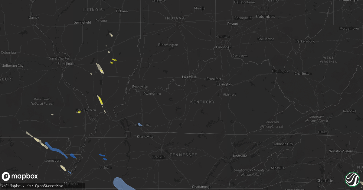
Hail Map in Kentucky on May 6, 2021
Get this storm
May 6 map
$229
one time, instant access
Download today. No call, no setup
Keep the $229
Bought the map and want the full workflow? Apply the entire $229 to a subscription within 7 days. None of it is wasted.
Every map, not just this one
This buys you this map. Subscription and you get every map we run, in the markets you choose from a few cities to whole states to nationwide. Plus real-time alerts the moment a storm fires.
Contact data
Name, contact info, occupancy, even credit band for addresses in the footprint. You go from where it hit to who to call.
Become the source they trust
Unlimited branding weather history reports on demand. You already have the documented answer ready for the property owner, and you are the one who showed up with it.
Property data and RoofTrace estimates
Pull up any address you have got, its value and the exact code rules for that jurisdiction, straight from One Click Code. Then RoofTrace estimates the squares, pitch, and roof value, priced the way you price.
Storm reports in Kentucky
Kentucky
| Date | Description |
|---|---|
| 05/06/20214:15 PM CDT | Large tree down on vacant house. |
| 05/06/20214:11 PM CDT | Several trees reported down. |
| 05/06/20213:30 PM CDT | Tree on a mobile home... Tree on a powerline in northern murray. 40 customers w/o power on the murray elec. Grid... 85 customers w/o power on wky elec. Grid. |
| 05/06/202112:29 AM CDT | At 528 PM CDT, a severe thunderstorm was located near Portland, or 10 miles north of Gallatin, moving east at 35 mph. HAZARD...60 mph wind gusts. SOURCE...Radar indicated. IMPACT...Expect damage to roofs, siding, and trees. Locations impacted include... Gallatin, Lafayette, Hartsville, White House, Westmoreland, Portland, Mitchellville, Cottontown, Bethpage, Oak Grove and Bledsoe Creek State Park. |
| 05/05/202111:56 PM CDT | At 456 PM CDT, severe thunderstorms were located along a line extending from 10 miles southeast of Russellville to near Springfield to near Coopertown, moving east at 35 mph. HAZARD...60 mph wind gusts. SOURCE...Radar indicated. IMPACT...Expect damage to roofs, siding, and trees. Locations impacted include... Gallatin, Springfield, Hendersonville, Goodlettsville, White House, Millersville, Greenbrier, Coopertown, Westmoreland, Ridgetop, Cross Plains, Portland, Pleasant View, Orlinda, Mitchellville, Bethpage, Oak Grove, Cottontown and Black Jack.This includes the following highways... Interstate 65 between mile markers 99 and 121. Interstate 24 between mile markers 23 and 28. |
| 05/05/202111:27 PM CDT | At 427 PM CDT, severe thunderstorms were located along a line extending from near Elkton to 6 miles north of McEwen, moving east at 30 mph. HAZARD...60 mph wind gusts. SOURCE...Radar indicated. IMPACT...Expect damage to roofs, siding, and trees. Locations impacted include... Springfield, Ashland City, Erin, Clarksville, Coopertown, Guthrie, Tennessee Ridge, Pleasant View, Adams, Vanleer, Cedar Hill, Cumberland City, Slayden, Cheatham Dam, Palmyra, Woodlawn and Cunningham.This includes Interstate 24 between mile markers 1 and 28. |
| 05/05/202111:04 PM CDT | At 403 PM CDT, a severe thunderstorm was located near Big Rock, or 9 miles northeast of Dover, moving east at 30 mph. HAZARD...60 mph wind gusts. SOURCE...Radar indicated. IMPACT...Expect damage to roofs, siding, and trees. Locations impacted include... Dover, Clarksville, Big Rock, Cumberland City, Land Between The Lakes, Indian Mound, Palmyra, Cunningham and Woodlawn.This includes Interstate 24 between mile markers 1 and 8. |
| 05/05/202110:53 PM CDT | At 352 PM CDT, severe thunderstorms were located along a line extending from 7 miles east of Crofton to Hopkinsville, moving east at 40 mph. HAZARD...60 mph wind gusts and penny size hail. SOURCE...Radar indicated. IMPACT...Expect damage to roofs, siding, and trees. Locations impacted include... Hopkinsville, Oak Grove, Elkton, Fort Campbell, Clarksville, Guthrie, Pembroke, Crofton, Trenton, and Herndon. This includes the following highways... Interstate 24 in Kentucky between Mile Markers 73 and 92. Pennyrile Parkway between Mile Markers 1 and 25. |
All States Impacted by Hail Map on May 6, 2021
Cities Impacted by Hail Map on May 6, 2021
- Windsor, IL
- Lumber Bridge, NC
- Parkton, NC
- Saint Pauls, NC
- Mount Vernon, IL
- Dix, IL
- Aberdeen, NC
- Pinebluff, NC
- Southern Pines, NC
- Fort Bragg, NC
- Belle Glade, FL
- Tyronza, AR
- Dyess, AR
- Lepanto, AR
- Marked Tree, AR
- Texico, IL
- Crescent City, FL
- Georgetown, FL
- Ravenden, AR
- Ravenden Springs, AR
- Imboden, AR
- Pocahontas, AR
- Palm Beach Gardens, FL
- Odin, IL
- Sandoval, IL
- Goreville, IL
- Marion, IL
- Carbondale, IL
- Altoona, FL
- Koshkonong, MO
- Thayer, MO
- Couch, MO
- West Palm Beach, FL
- Deland, FL
- Laurinburg, NC
- Blytheville, AR
- Bunnell, FL
- Altamont, IL
- Flora, IL
- Xenia, IL
- Mammoth Spring, AR
- Shannon, NC
- Raeford, NC
- Red Springs, NC
- Edgewood, IL
- Mason, IL
- Stuart, FL
- Palm City, FL
- Louisville, IL
- Metropolis, IL
- New Smyrna Beach, FL
- Chaffee, MO
- Whitewater, MO
- Cape Girardeau, MO
- Wagram, NC
- Jupiter, FL
- Loxahatchee, FL
- Vienna, IL
- Clewiston, FL
- South Bay, FL
- Advance, MO
- Hoffman, NC
- Ozark, IL
- Buncombe, IL
- Boca Raton, FL
- Joiner, AR
- Jackson Springs, NC
- Pinehurst, NC
- Vass, NC
- Salem, IL
- Kell, IL
- Centralia, IL
- Walnut Hill, IL
- Ashley, IL
- Nashville, IL
- Piedmont, MO
- Okeechobee, FL
- Ormond Beach, FL
- Walnut Ridge, AR
- Seville, FL
- Trenton, TN
- Milan, TN
- Medina, TN
- Humboldt, TN
- Guys, TN
- Crump, TN
- Killen, AL
- Sheffield, AL
- Counce, TN
- Burnsville, MS
- Savannah, TN
- Waterloo, AL
- Muscle Shoals, AL
- Iuka, MS
- Michie, TN
- Selmer, TN
- Cherokee, AL
- Shiloh, TN
- Town Creek, AL
- Lutts, TN
- Tuscumbia, AL
- Stantonville, TN
- Morris Chapel, TN
- Leighton, AL
- Florence, AL
- Cypress Inn, TN
- Adamsville, TN
- Hopkinsville, KY
- Gracey, KY
- Booneville, MS
- Rienzi, MS
- Corinth, MS
- Marietta, MS
- Baldwyn, MS
- New Site, MS
- Fulton, MS
- Shannon, MS
- Nettleton, MS
- Mantachie, MS
- Dumas, MS
- Blue Springs, MS
- Ecru, MS
- New Albany, MS
- Saltillo, MS
- Belden, MS
- Plantersville, MS
- Tupelo, MS
- Guntown, MS
- Pontotoc, MS
- Mooreville, MS
- Verona, MS
- Clay City, IL
- Hoopeston, IL
- North Palm Beach, FL
- Delaplaine, AR
- Biggers, AR
- Maynard, AR
- Peach Orchard, AR
- Paragould, AR
- Leachville, AR
- Marmaduke, AR
- Monette, AR
- Manila, AR
- Beech Grove, AR
- Cardwell, MO
- Steele, MO


