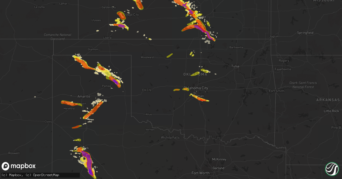
Hail Map in Oklahoma on May 5, 2019
Get this storm
May 5 map
$229
one time, instant access
Download today. No call, no setup
Keep the $229
Bought the map and want the full workflow? Apply the entire $229 to a subscription within 7 days. None of it is wasted.
Every map, not just this one
This buys you this map. Subscription and you get every map we run, in the markets you choose from a few cities to whole states to nationwide. Plus real-time alerts the moment a storm fires.
Contact data
Name, contact info, occupancy, even credit band for addresses in the footprint. You go from where it hit to who to call.
Become the source they trust
Unlimited branding weather history reports on demand. You already have the documented answer ready for the property owner, and you are the one who showed up with it.
Property data and RoofTrace estimates
Pull up any address you have got, its value and the exact code rules for that jurisdiction, straight from One Click Code. Then RoofTrace estimates the squares, pitch, and roof value, priced the way you price.
Storm reports in Oklahoma
Oklahoma
| Date | Description |
|---|---|
| 05/05/20196:35 AM CDT | At 1134 PM CDT, severe thunderstorms were located along a line extending from 4 miles west of Marland to 4 miles southwest of Perry to 3 miles west of Orlando to near Lovell, moving east at 40 mph. HAZARD...60 mph wind gusts and quarter size hail. SOURCE...Radar indicated. IMPACT...Hail damage to vehicles is expected. Expect wind damage to roofs, siding, and trees. Locations impacted include... Stillwater, Guthrie, Perry, Perkins, Langston, Crescent, Morrison, Glencoe, Coyle, Cedar Valley, Red Rock, Mulhall, Marland, Cimarron City, Orlando, Lake Carl Blackwell, Lake Mcmurtry, Lovell, Sooner Lake and Ingalls. |
| 05/05/20196:14 AM CDT | At 1113 PM CDT, a severe thunderstorm was located near Concho, moving east at 15 mph. HAZARD...60 mph wind gusts and quarter size hail. SOURCE...Radar indicated. IMPACT...Hail damage to vehicles is expected. Expect wind damage to roofs, siding, and trees. Locations impacted include... Northwestern Oklahoma City, Piedmont, Okarche, Concho and Richland. |
| 05/05/20196:08 AM CDT | At 1108 PM CDT, a severe thunderstorm was located 6 miles southeast of Clinton, moving east at 30 mph. HAZARD...Ping pong ball size hail and 60 mph wind gusts. SOURCE...Radar indicated. IMPACT...People and animals outdoors will be injured. Expect hail damage to roofs, siding, windows, and vehicles. Expect wind damage to roofs, siding, and trees. Locations impacted include... Weatherford, Clinton, Corn and Colony. This includes Interstate 40 between mile markers 67 and 85. |
| 05/05/20196:05 AM CDT | At 1105 PM CDT, severe thunderstorms were located along a line extending from 3 miles north of Hunter to near Breckenridge to near Waukomis, moving east at 30 mph. HAZARD...60 mph wind gusts and quarter size hail. SOURCE...Radar indicated. IMPACT...Hail damage to vehicles is expected. Expect wind damage to roofs, siding, and trees. Locations impacted include... Enid, Ponca City, Perry, Tonkawa, Waukomis, Garber, Covington, Billings, Red Rock, Marshall, Breckenridge, Marland, Hunter, Fairmont, Douglas, Lovell, Lucien, Bison, Ceres and Hayward. |
| 05/05/20195:44 AM CDT | At 1044 PM CDT, severe thunderstorms were located along a line extending from near Kremlin to 3 miles east of Lahoma to near Meno, moving southeast at 15 mph. HAZARD...60 mph wind gusts and quarter size hail. SOURCE...Radar indicated. IMPACT...Hail damage to vehicles is expected. Expect wind damage to roofs, siding, and trees. Locations impacted include... Enid, Waukomis, Garber, Lahoma, Covington, Ringwood, Drummond, Kremlin, Breckenridge, Ames, Meno, Fairmont, Carrier, Douglas, Vance Air Force Base, Bison and North Enid. |
| 05/05/20195:39 AM CDT | At 1039 PM CDT, a severe thunderstorm was located 4 miles west of Hardy, moving southeast at 15 mph. HAZARD...Two inch hail and 60 mph wind gusts. SOURCE...Radar indicated. IMPACT...People and animals outdoors will be injured. Expect hail damage to roofs, siding, windows, and vehicles. Expect wind damage to roofs, siding, and trees. Locations impacted include... Hardy and northeastern Kaw Lake. |
| 05/05/20195:37 AM CDT | At 1037 PM CDT, a severe thunderstorm was located 7 miles southeast of Hinton, moving northeast at 20 mph. HAZARD...60 mph wind gusts and quarter size hail. SOURCE...Radar indicated. IMPACT...Hail damage to vehicles is expected. Expect wind damage to roofs, siding, and trees. Locations impacted include... El Reno, Union City, Concho and Cedar Lake. |
| 05/05/20195:21 AM CDT | At 1021 PM CDT, severe thunderstorms were located along a line extending from 3 miles east of Nash to near Goltry to near Cleo Springs, moving south at 15 mph. HAZARD...60 mph wind gusts and quarter size hail. SOURCE...Radar indicated. IMPACT...Hail damage to vehicles is expected. Expect wind damage to roofs, siding, and trees. Locations impacted include... Enid, Fairview, Helena, Lahoma, Ringwood, Cleo Springs, Goltry, Meno, Aline, Nash, Hillsdale, Carrier and Orienta. |
| 05/05/20195:02 AM CDT | At 1001 PM CDT, a severe thunderstorm was located near Arkansas City, moving southeast at 30 mph. HAZARD...Golf ball size hail and 60 mph wind gusts. SOURCE...Radar indicated. IMPACT...People and animals outdoors will be injured. Expect hail damage to roofs, siding, windows, and vehicles. Expect wind damage to roofs, siding, and trees. Locations impacted include... Kaw City, Hardy and northern Kaw Lake. |
| 05/05/20194:34 AM CDT | At 934 PM CDT, severe thunderstorms were located along a line extending from 6 miles south of Aetna to 3 miles northeast of Billings, moving northeast at 30 mph. HAZARD...60 mph wind gusts and quarter size hail. SOURCE...Radar indicated. IMPACT...Hail damage to vehicles is expected. Expect wind damage to roofs, siding, and trees. Locations impacted include... Alva, Cherokee, Medford, Helena, Pond Creek, Lamont, Carmen, Wakita, Kremlin, Goltry, Jet, Nash, Hunter, Burlington, Deer Creek, Hillsdale, Dacoma, Manchester, Amorita and Byron. |
| 05/05/20194:25 AM CDT | At 925 PM CDT, a severe thunderstorm was located 6 miles northwest of New Mobeetie, or 9 miles southeast of Miami, moving southeast at 25 mph. HAZARD...70 mph wind gusts and ping pong ball size hail. SOURCE...Radar indicated. IMPACT...Expect some tree damage. Damage is likely to mobile homes, roofs, and outbuildings. People and animals outdoors will be injured. Expect hail damage to roofs, siding, windows, and vehicles. Locations impacted include... Briscoe, Wheeler, New Mobeetie, Twitty, Allison, Kellerville and Mobeetie. |
| 05/05/20194:21 AM CDT | At 921 PM CDT, a severe thunderstorm was located 4 miles southwest of Hunter, moving east at 20 mph. HAZARD...60 mph wind gusts and quarter size hail. SOURCE...Radar indicated. IMPACT...Hail damage to vehicles is expected. Expect wind damage to roofs, siding, and trees. Locations impacted include... Enid, Garber, Kremlin, Breckenridge and Hunter. |
| 05/05/20194:17 AM CDT | At 916 PM CDT, a severe thunderstorm was located 4 miles west of Lamont, moving east at 15 mph. HAZARD...60 mph wind gusts and quarter size hail. SOURCE...Radar indicated. IMPACT...Hail damage to vehicles is expected. Expect wind damage to roofs, siding, and trees. Locations impacted include... Blackwell, Tonkawa, Lamont, Deer Creek and Nardin. |
| 05/05/20194:15 AM CDT | At 915 PM CDT, a severe thunderstorm was located near Goltry, moving northeast at 25 mph. HAZARD...60 mph wind gusts and quarter size hail. SOURCE...Radar indicated. IMPACT...Hail damage to vehicles is expected. Expect wind damage to roofs, siding, and trees. Locations impacted include... Pond Creek, Goltry, Nash and Hillsdale. |
| 05/05/20193:56 AM CDT | At 855 PM CDT, severe thunderstorms were located along a line extending from 3 miles southwest of Aline to 4 miles northwest of Isabella, moving northeast at 25 mph. HAZARD...Ping pong ball size hail and 60 mph wind gusts. SOURCE...Radar indicated. IMPACT...People and animals outdoors will be injured. Expect hail damage to roofs, siding, windows, and vehicles. Expect wind damage to roofs, siding, and trees. Locations impacted include... Helena, Ringwood, Cleo Springs, Meno, Aline and Orienta. |
| 05/05/20193:53 AM CDT | At 853 PM CDT, a severe thunderstorm was located near Ingersoll, moving east at 20 mph. HAZARD...Ping pong ball size hail and 60 mph wind gusts. SOURCE...Radar indicated. IMPACT...People and animals outdoors will be injured. Expect hail damage to roofs, siding, windows, and vehicles. Expect wind damage to roofs, siding, and trees. Locations impacted include... Cherokee, Byron, Great Salt Plains Lake, Driftwood and Ingersoll. |
| 05/05/20193:37 AM CDT | At 837 PM CDT, severe thunderstorms were located along a line extending from 10 miles northwest of Orienta to near Fairview, moving northeast at 25 mph. HAZARD...Ping pong ball size hail. SOURCE...Radar indicated. IMPACT...People and animals outdoors will be injured. Expect damage to roofs, siding, windows, and vehicles. Locations impacted include... Fairview, Cleo Springs, Aline, Isabella and Orienta. |
| 05/05/20193:30 AM CDT | At 830 PM CDT, a severe thunderstorm was located 5 miles northeast of Dacoma, moving northeast at 20 mph. HAZARD...Ping pong ball size hail and 60 mph wind gusts. SOURCE...Radar indicated. IMPACT...People and animals outdoors will be injured. Expect hail damage to roofs, siding, windows, and vehicles. Expect wind damage to roofs, siding, and trees. Locations impacted include... Cherokee, Lambert, Driftwood and Ingersoll. |
| 05/05/20192:54 AM CDT | At 753 PM CDT, a severe thunderstorm was located 17 miles southeast of Spearman, moving east at 35 mph. HAZARD...Golf ball size hail and 70 mph wind gusts. SOURCE...Radar indicated. IMPACT...Expect some tree damage. Damage is likely to mobile homes, roofs, and outbuildings. People and animals outdoors will be injured. Expect hail damage to roofs, siding, windows, and vehicles. Locations impacted include... Pampa, Canadian, Miami, Briscoe, Wheeler, Lefors, Higgins, New Mobeetie, Allison, Glazier, Lake Marvin, Lora, Codman and Mobeetie. |
| 05/05/20192:33 AM CDT | Strong thunderstorm wind blew down trees... Some onto homes... And destroyed car ports. Time estimated based on radar. |
| 05/05/20192:13 AM CDT | Tree damage in town. Lots of 2-4 inch diameter limbs and a few 2-3 foot limbs down. Time estimated by radar. |
| 05/05/20192:05 AM CDT | Power lines down along hwy 48 north of castle. Time estimated by radar. |
| 05/05/20191:35 AM CDT | Mping. |
| 05/05/20191:30 AM CDT | Time estimated by radar. |
| 05/05/20191:15 AM CDT | A local report indicates 1.50 inch wind near 3 SSE NORMAN |
| 05/05/20191:12 AM CDT | A local report indicates 1.00 inch wind near NOBLE |
| 05/05/201912:55 AM CDT | A local report indicates 1.25 inch wind near 2 SW NORMAN |
| 05/05/201912:43 AM CDT | A local report indicates 1.00 inch wind near 4 WNW NEWCASTLE |
| 05/05/201912:30 AM CDT | Time estimated from radar. |
| 05/05/201912:26 AM CDT | Storm spotter measured a brief gust to 75 mph near lela on the pawnee and noble county line. Relayed by media via nwschat. |
| 05/04/201911:52 PM CDT | Large barn destroyed... Trees snapped... Cars flipped. Time is radar estimate. |
| 05/04/201911:40 PM CDT | Trees and power poles down. |
| 05/04/201911:34 PM CDT | At 434 PM CDT, a severe thunderstorm was located 8 miles northwest of Stratford, moving southeast at 20 mph. HAZARD...60 mph wind gusts and quarter size hail. SOURCE...Radar indicated. IMPACT...Minor damage to roofs, siding, and trees is possible. Hail damage to vehicles is expected. Locations impacted include... Stratford, Gruver, Griggs, Conlen and Texhoma. |
| 05/04/201911:30 PM CDT | Large barn destroyed. |
| 05/04/201910:55 PM CDT | A local report indicates 65 MPH wind near KREMLIN |
| 05/04/20199:40 PM CDT | A local report indicates 1.00 inch wind near HUNTER |
All States Impacted by Hail Map on May 5, 2019
Cities Impacted by Hail Map on May 5, 2019
- Tahoka, TX
- Lincoln, NE
- Canadian, TX
- Naponee, NE
- Bloomington, NE
- Hildreth, NE
- Wilcox, NE
- Republican City, NE
- Geneva, NE
- Blair, NE
- Malcolm, NE
- Valparaiso, NE
- Bee, NE
- Pleasant Dale, NE
- Raymond, NE
- Dwight, NE
- Seward, NE
- Garland, NE
- Campbell, NE
- Upland, NE
- Spearman, TX
- Stinnett, TX
- Lubbock, TX
- Levelland, TX
- Surprise, NE
- Shelby, NE
- Gresham, NE
- Peck, KS
- Holstein, NE
- Clarendon, TX
- Gail, TX
- Edgar, NE
- Ong, NE
- Lake View, IA
- Fairfield, NE
- Glenvil, NE
- Clay Center, NE
- Saronville, NE
- Jewell, KS
- Washington, OK
- Newcastle, OK
- Norman, OK
- Sunray, TX
- Abernathy, TX
- Shallowater, TX
- Brownfield, TX
- Plains, KS
- Montezuma, KS
- Sublette, KS
- Copeland, KS
- Fowler, KS
- Meade, KS
- Andrews, TX
- Miami, TX
- Spearville, KS
- Groom, TX
- Minden, NE
- Sedgwick, KS
- Halstead, KS
- Jetmore, KS
- Imperial, TX
- Giltner, NE
- Grafton, NE
- Trumbull, NE
- Central City, NE
- Harvard, NE
- Henderson, NE
- Doniphan, NE
- Marquette, NE
- Phillips, NE
- Aurora, NE
- Hampton, NE
- Saint Libory, NE
- Archer, NE
- Sutton, NE
- Chapman, NE
- Colwich, KS
- Colon, NE
- Cedar Bluffs, NE
- Claude, TX
- Tuttle, OK
- Blanchard, OK
- Shickley, NE
- Grand Island, NE
- Blue Hill, NE
- Lawrence, NE
- Mcpherson, KS
- Wilson, TX
- Morse, TX
- Hereford, TX
- Burrton, KS
- Haven, KS
- Mobeetie, TX
- Wolfforth, TX
- Ropesville, TX
- McGregor, IA
- Brainard, NE
- Cimarron, KS
- Lexington, OK
- Noble, OK
- Hastings, NE
- Callender, IA
- Waverly, NE
- Wheeler, TX
- Alma, NE
- Raymond, KS
- Braman, OK
- Newkirk, OK
- Geuda Springs, KS
- South Haven, KS
- Stratford, TX
- Dalhart, TX
- Gruver, TX
- Nickerson, KS
- Freedom, OK
- Ulysses, NE
- Concordia, KS
- Great Bend, KS
- Perkins, OK
- Stillwater, OK
- Coyle, OK
- Roseland, NE
- Ayr, NE
- Utica, NE
- Weston, NE
- David City, NE
- Garden Plain, KS
- Coyanosa, TX
- Guthrie, OK
- Hunter, OK
- Douglass, KS
- Rock, KS
- Udall, KS
- Ceresco, NE
- Hutchinson, KS
- Fort Stockton, TX
- Orleans, NE
- Perryton, TX
- Pampa, TX
- Juniata, NE
- Odonnell, TX
- Bladen, NE
- Andale, KS
- Goddard, KS
- Wichita, KS
- Ellinwood, KS
- Fremont, NE
- Haysville, KS
- Clearwater, KS
- Happy, TX
- Tulia, TX
- Hanston, KS
- Burdett, KS
- Duncombe, IA
- Unadilla, NE
- Sterling, KS
- Alden, KS
- Valley, NE
- Lyons, KS
- South Hutchinson, KS
- Chase, KS
- Buhler, KS
- Claflin, KS
- Milford, NE
- Inland, NE
- Oxford, KS
- Wellington, KS
- Ensign, KS
- Conway Springs, KS
- Oklahoma City, OK
- Maize, KS
- Tucumcari, NM
- Mcloud, OK
- Clermont, IA
- Postville, IA
- Mead, NE
- Yutan, NE
- Anton, TX
- Viola, KS
- Ashland, KS
- Elkader, IA
- Wanette, OK
- Cheney, KS
- Post, TX
- Lamesa, TX
- Slaton, TX
- Abbyville, KS
- Orlando, FL
- Billings, OK
- Kress, TX
- Ness City, KS
- Mount Hope, KS
- Valley Center, KS
- Herman, NE
- Arlington, NE
- Syracuse, NE
- Avoca, NE
- Rockwell City, IA
- Hugoton, KS
- Moscow, KS
- Randall, KS
- Rose Hill, KS
- Dodge City, KS
- Denton, NE
- Stamford, NE
- Bruno, NE
- Prairie Du Chien, WI
- Derby, KS
- Kermit, TX
- Garber, OK
- Kenesaw, NE
- Franklin, NE
- Riverton, NE
- Canyon, TX
- Silverton, TX
- Olmitz, KS
- Hoisington, KS
- Plevna, KS
- Meadow, TX
- Dexter, KS
- Nelson, NE
- Otho, IA
- Luana, IA
- Craig, NE
- Somers, IA
- Orlando, OK
- Cushing, OK
- Eagle, NE
- Walton, NE
- Elmwood, NE
- Palmyra, NE
- La Crosse, KS
- Davey, NE
- Winfield, KS
- Arkansas City, KS
- Mazomanie, WI
- Moundridge, KS
- Bison, KS
- Garden City, KS
- Wahoo, NE
- Malmo, NE
- Ponca City, OK
- Jamestown, KS
- Garnavillo, IA
- Harper, KS
- Ingalls, KS
- Beloit, KS
- Glasco, KS
- Wayside, TX
- Fort Dodge, IA
- El Reno, OK
- Union City, OK
- Smyer, TX
- Texhoma, OK
- Encinal, TX
- Belle Plaine, KS
- Argonia, KS
- Murdock, NE
- Moorland, IA
- La Valle, WI
- Cazenovia, WI
- Reedsburg, WI
- Cashton, WI
- Westby, WI
- Inman, KS
- Genoa, WI
- Maple City, KS
- Milton, KS
- Pretty Prairie, KS
- Mulvane, KS
- Partridge, KS
- Sharon Springs, KS
- Wallace, KS
- Wilson, KS
- Holdrege, NE
- Fluvanna, TX
- Aurora, KS
- Tekamah, NE
- Staplehurst, NE
- Linwood, NE
- Wildorado, TX
- Rexford, KS
- Formoso, KS
- Sylvia, KS
- Otis, KS
- Protection, KS
- Jal, NM
- Prague, NE
- Waukon, IA
- Bradshaw, NE
- Mcconnell Afb, KS
- Osceola, NE
- Stromsburg, NE
- Otoe, NE
- Alvo, NE
- Alpine, TX
- Dow City, IA
- Littlefield, TX
- Rising City, NE
- Little River, KS
- Richland Center, WI
- Briscoe, TX
- Guide Rock, NE
- Palmer, NE
- Deweese, NE
- Kismet, KS
- Plainview, TX
- Olton, TX
- Bennet, NE
- Roca, NE
- Greenwood, NE
- Oxford, NE
- Kennard, NE
- Nickerson, NE
- Hooper, NE
- Winter Garden, FL
- Saint Petersburg, FL
- Clearwater, FL
- Pinellas Park, FL
- Seminole, FL
- Indian Rocks Beach, FL
- Largo, FL
- Zellwood, FL
- Apopka, FL
- Safety Harbor, FL
- Tampa, FL
- Oldsmar, FL
- Groveland, FL
- Sumterville, FL
- Okahumpka, FL
- Howey In The Hills, FL
- Leesburg, FL
- Center Hill, FL
- Lakeland, FL
- Springlake, TX
- Offerle, KS
- Kinsley, KS
- McCracken, KS
- Rush Center, KS
- Nekoma, KS
- Norwich, KS
- Danville, KS
- Mayfield, KS
- Murdock, KS
- Hudson, KS
- Aline, OK
- Carmen, OK
- Waynoka, OK
- Cleo Springs, OK
- Hinton, OK
- Lookeba, OK
- Enid, OK
- Yukon, OK
- Mustang, OK
- Crescent, OK
- Cashion, OK
- Mulhall, OK
- Purcell, OK


