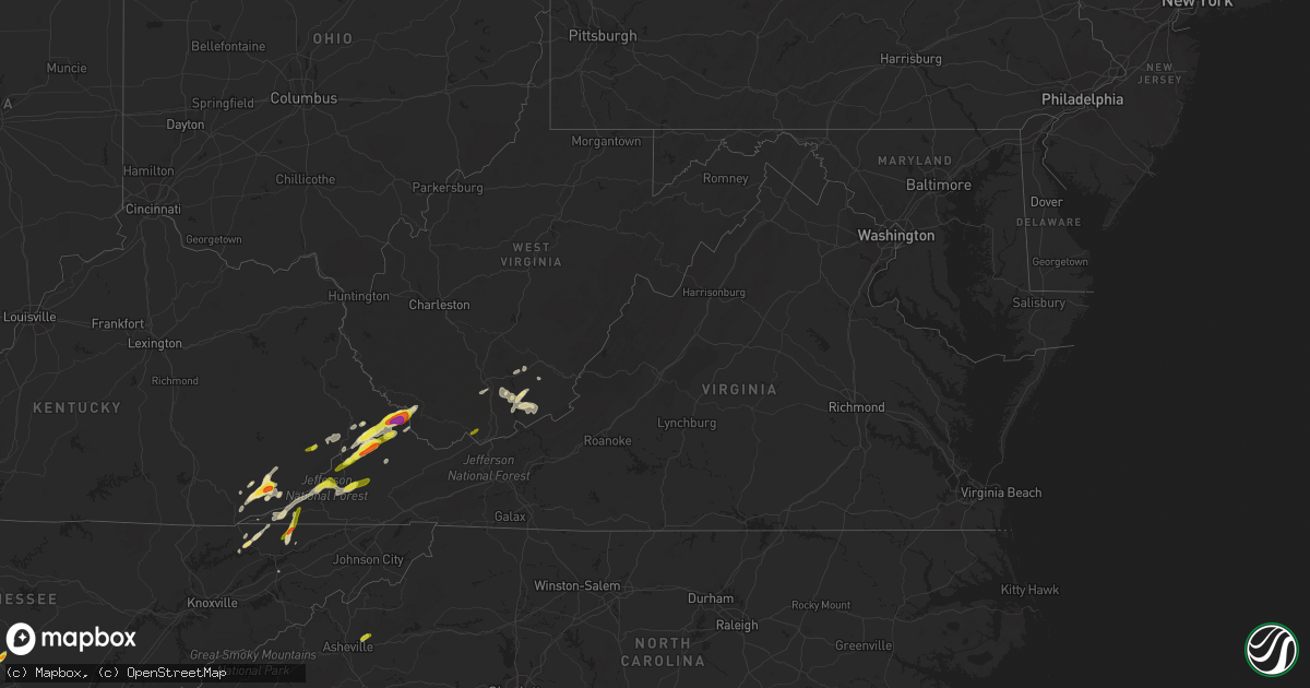
Hail Map in Virginia on May 5, 2018
Get this storm
May 5 map
$229
one time, instant access
Download today. No call, no setup
Keep the $229
Bought the map and want the full workflow? Apply the entire $229 to a subscription within 7 days. None of it is wasted.
Every map, not just this one
This buys you this map. Subscription and you get every map we run, in the markets you choose from a few cities to whole states to nationwide. Plus real-time alerts the moment a storm fires.
Contact data
Name, contact info, occupancy, even credit band for addresses in the footprint. You go from where it hit to who to call.
Become the source they trust
Unlimited branding weather history reports on demand. You already have the documented answer ready for the property owner, and you are the one who showed up with it.
Property data and RoofTrace estimates
Pull up any address you have got, its value and the exact code rules for that jurisdiction, straight from One Click Code. Then RoofTrace estimates the squares, pitch, and roof value, priced the way you price.
Storm reports in Virginia
Virginia
| Date | Description |
|---|---|
| 05/05/20185:35 PM CDT | Quarter size hail reported around the pennington gap area |
| 05/05/20184:53 PM CDT | A local report indicates 1.00 inch wind near 4 SW TRAMMEL |
| 05/05/20183:55 PM CDT | A local report indicates 1.75 inch wind near 1 NW HURLEY |
| 05/05/20183:55 PM CDT | Via social media with picture |
| 05/05/20183:52 PM CDT | A local report indicates 1.75 inch wind near HAYSI |
| 05/05/20183:50 PM CDT | Half dollar to golf ball hail. Cars dented. |
| 05/05/20183:50 PM CDT | At flanagan marina |
| 05/05/20183:25 PM CDT | A local report indicates 1.25 inch wind near CLINTWOOD |
| 05/05/20183:24 AM CDT | At 823 PM EDT, severe thunderstorms were located along a line extending from near Frankford to near Cascades, moving east at 45 mph. HAZARD...60 mph wind gusts and quarter size hail. SOURCE...Radar indicated. IMPACT...Hail damage to vehicles is expected. Expect wind damage to roofs, siding, and trees. Locations impacted include... Alleghany... Lewisburg... White Sulphur Springs... Ronceverte... and Union.This includes The following Location The West Virginia StateFairgrounds. |
| 05/05/201812:47 AM CDT | At 547 PM EDT, a severe thunderstorm was located near Trammel, or 10 miles east of Wise, moving northeast at 35 mph. HAZARD...60 mph wind gusts and quarter size hail. SOURCE...Radar indicated. IMPACT...Hail damage to vehicles is expected. Expect wind damage to roofs, siding, and trees. Locations impacted include... Davenport, Trammel and Nora. |
| 05/05/201812:27 AM CDT | At 527 PM EDT, a severe thunderstorm was located 8 miles southeast of Wise, moving northeast at 25 mph. HAZARD...60 mph wind gusts and quarter size hail. SOURCE...Radar indicated. IMPACT...Hail damage to vehicles is expected. Expect wind damage to roofs, siding, and trees. Locations impacted include... Norton, Cleveland Va, Coeburn, St. Paul, Dungannon, Castlewood and Fort Blackmore. |
| 05/05/201812:02 AM CDT | At 502 PM EDT, a severe thunderstorm was located near Big Stone Gap, or near Norton, moving northeast at 35 mph. HAZARD...60 mph wind gusts and quarter size hail. SOURCE...Radar indicated. IMPACT...Hail damage to vehicles is expected. Expect wind damage to roofs, siding, and trees. Locations impacted include... Norton, Wise, Big Stone Gap, Coeburn, Appalachia, Pound and Pardee. |
| 05/04/201811:50 PM CDT | At 450 PM EDT, a severe thunderstorm was located over Argo, or 14 miles north of Grundy, moving northeast at 30 mph. HAZARD...70 mph wind gusts and half dollar size hail. SOURCE...Radar indicated. IMPACT...Hail damage to vehicles is expected. Expect considerable tree damage. Wind damage is also likely to mobile homes, roofs, and outbuildings. Locations impacted include... Welch, Pineville, Oceana, Hanover, R.d. Bailey Lake, Mallory, Gilbert Creek, Hinch, Amherstdale-Robinette, Gilbert, Davy, Iaeger, Clear Fork, Panther, Cyclone, Coal Mountain, Hampden, Bruno, Hurley and Avondale. |
| 05/04/201811:41 PM CDT | At 440 PM EDT, a severe thunderstorm was located near John Flannagan Lake, moving northeast at 30 mph. HAZARD...60 mph wind gusts and half dollar size hail. SOURCE...Radar indicated. IMPACT...Hail damage to vehicles is expected. Expect wind damage to roofs, siding, and trees. Locations impacted include... Grundy, Haysi, Breaks Interstate, John Flannagan Lake, Big Rock and Clinchco. |
| 05/04/201811:10 PM CDT | At 409 PM EDT, a severe thunderstorm was located near Gaskill, or near Clintwood, moving northeast at 25 mph. HAZARD...60 mph wind gusts and quarter size hail. SOURCE...Radar indicated. IMPACT...Hail damage to vehicles is expected. Expect wind damage to roofs, siding, and trees. Locations impacted include... Clintwood, Haysi, John Flannagan Lake and Clinchco. |
All States Impacted by Hail Map on May 5, 2018
Cities Impacted by Hail Map on May 5, 2018
- Chaska, MN
- Carver, MN
- Shakopee, MN
- Elkhorn City, KY
- Wallins Creek, KY
- Helton, KY
- Bledsoe, KY
- Haysi, VA
- Clintwood, VA
- Clinchco, VA
- Baxter, KY
- Coldiron, KY
- Dayhoit, KY
- Virgie, KY
- Kite, KY
- Deane, KY
- Bevinsville, KY
- Weeksbury, KY
- New Tazewell, TN
- Tazewell, TN
- Norton, VA
- Appalachia, VA
- Big Stone Gap, VA
- Keokee, VA
- Pound, VA
- Manchester, TN
- Morristown, TN
- Coeburn, VA
- Stopover, KY
- Steele, KY
- Phelps, KY
- Hurley, VA
- Ashcamp, KY
- Belcher, KY
- Warbranch, KY
- Pikeville, KY
- Beechgrove, TN
- Hinton, WV
- Forest Hill, WV
- Ages Brookside, KY
- Greenville, WV
- Ballard, WV
- Nimitz, WV
- Jumping Branch, WV
- Pineville, KY
- Stoney Fork, KY
- Hulen, KY
- Harlan, KY
- Loyall, KY
- Glenville, MN
- Sneedville, TN
- Grundy, VA
- Big Rock, VA
- Asheville, NC
- Swannanoa, NC
- Black Mountain, NC
- Kyles Ford, TN
- Thorn Hill, TN
- Rogersville, TN
- Morrison, TN
- Mallie, KY
- Jonesville, VA
- Rose Hill, VA
- Lindside, WV
- Jenkins, KY
- Lick Creek, KY
- Miracle, KY
- Baisden, WV
- Wharncliffe, WV
- Mohawk, WV
- Fedscreek, KY
- Panther, WV
- Mouthcard, KY
- Pipestem, WV
- Ewing, VA
- Vansant, VA
- Bee, VA
- Davenport, VA
- Blackwater, VA
- Alderson, WV
- Cool Ridge, WV
- White Oak, WV
- Talcott, WV
- Wayside, WV
- Scarville, IA
- Lake Mills, IA
- Emmons, MN
- Shelbiana, KY
- Evarts, KY
- Meadow Bridge, WV
- Spring Dale, WV
- Saint Charles, VA
- Pennington Gap, VA
- Dryden, VA
- Dungannon, VA
- Arjay, KY
- Maiden Rock, WI
- Gilbert, WV
- Moscow, TN
- Coalgood, KY
- Yeaddiss, KY
- Kettle Island, KY
- Chappell, KY
- Coal City, WV
- Princewick, WV
- Shady Spring, WV
- Jeremiah, KY
- Whitesburg, KY
- Isom, KY
- Redfox, KY
- Sandstone, WV
- Coila, MS
- Ellsworth, WI
- Wise, VA
- Saint Paul, VA
- Freeman, WV
- Bramwell, WV
- Rock, WV
- Montcalm, WV
- Bluefield, WV
- Baker City, OR
- Haines, OR


