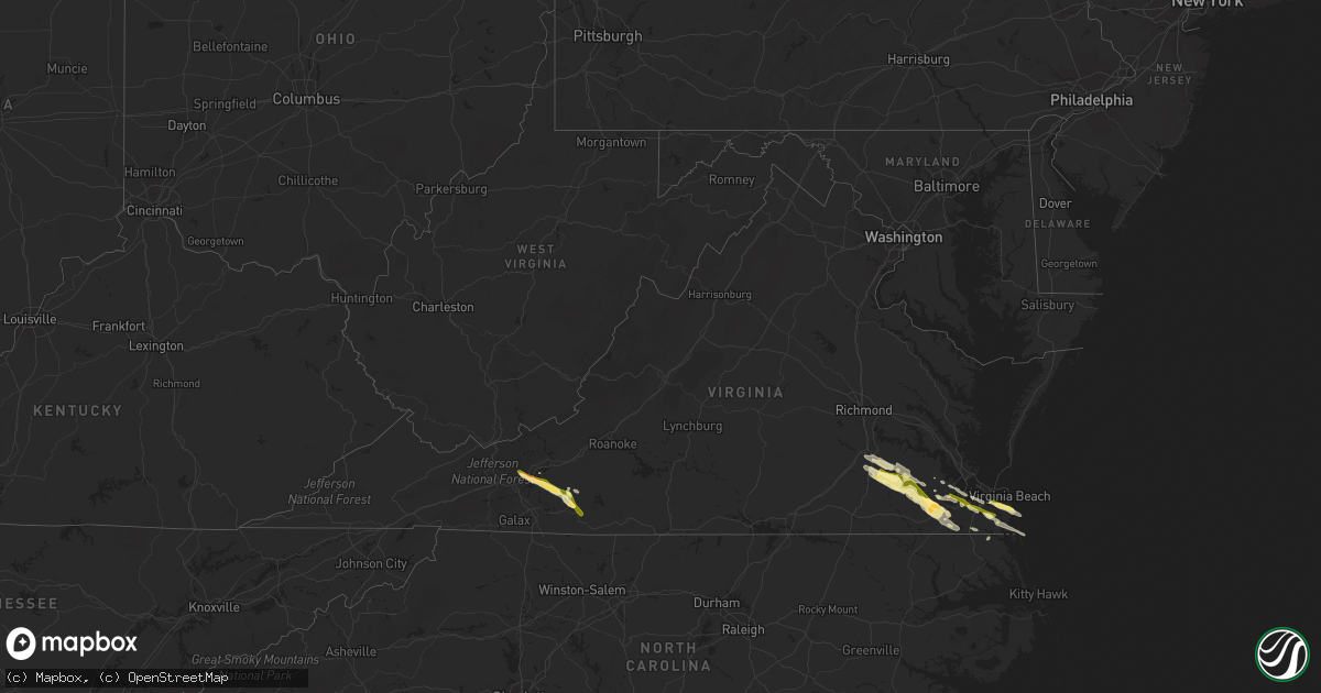
Hail Map in Virginia on May 5, 2014
Get this storm
May 5 map
$229
one time, instant access
Download today. No call, no setup
Keep the $229
Bought the map and want the full workflow? Apply the entire $229 to a subscription within 7 days. None of it is wasted.
Every map, not just this one
This buys you this map. Subscription and you get every map we run, in the markets you choose from a few cities to whole states to nationwide. Plus real-time alerts the moment a storm fires.
Contact data
Name, contact info, occupancy, even credit band for addresses in the footprint. You go from where it hit to who to call.
Become the source they trust
Unlimited branding weather history reports on demand. You already have the documented answer ready for the property owner, and you are the one who showed up with it.
Property data and RoofTrace estimates
Pull up any address you have got, its value and the exact code rules for that jurisdiction, straight from One Click Code. Then RoofTrace estimates the squares, pitch, and roof value, priced the way you price.
Storm reports in Virginia
Virginia
| Date | Description |
|---|---|
| 05/05/20143:49 PM CDT | A local report indicates 1.25 inch wind near 2 NE MEADOWS OF DAN |
| 05/05/20143:40 PM CDT | Duncans chapel rd |
| 05/05/20143:30 PM CDT | Indian valley rd |
| 05/05/20143:09 PM CDT | Holbert ave |
| 05/04/201411:20 PM CDT | A local report indicates 1.25 inch wind near MURDENS CORNER |
| 05/04/201411:15 PM CDT | Hail covered the ground |
| 05/04/201411:10 PM CDT | A local report indicates 1.00 inch wind near CHESAPEAKE |
| 05/04/201411:09 PM CDT | A local report indicates 1.00 inch wind near 1 SE ACREDALE |
| 05/04/201410:57 PM CDT | A local report indicates 1.00 inch wind near GHENT |
| 05/04/201410:15 PM CDT | A local report indicates 1.00 inch wind near 2 NNE WAVERLY |
| 05/04/201410:07 PM CDT | Nickel to quarter size |
| 05/04/20149:58 PM CDT | Via social media...up to ping pong ball size |
| 05/04/20149:38 PM CDT | A local report indicates 1.25 inch wind near WAKEFIELD |
All States Impacted by Hail Map on May 5, 2014
Cities Impacted by Hail Map on May 5, 2014
- Windsor, VA
- Indian Valley, VA
- Willis, VA
- Waverly, VA
- Petersburg, VA
- Disputanta, VA
- Floyd, VA
- Hardin, MT
- Virginia Beach, VA
- Suffolk, VA
- Crow Agency, MT
- Laurel, MT
- Park City, MT
- Devils Tower, WY
- Ballantine, MT
- Pulaski, VA
- Moorcroft, WY
- Meadows Of Dan, VA
- Chesapeake, VA
- Upton, WY
- Gillette, WY
- Billings, MT
- Draper, VA
- Hiwassee, VA
- Stuart, VA
- Huntley, MT
- Pompeys Pillar, MT
- Moyock, NC
- Zuni, VA
- Carrsville, VA
- Wakefield, VA
- Ivor, VA
- Sedley, VA
- Carson, VA
- Stony Creek, VA
- Carrollton, VA
- Portsmouth, VA
- Smithfield, VA
- Franklin, VA
- Norfolk, VA
- Corolla, NC
- Woolwine, VA


