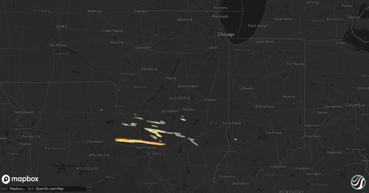
Hail Map in Illinois on May 3, 2026
Get this storm
May 3 map
$229
one time, instant access
Download today. No call, no setup
Keep the $229
Bought the map and want the full workflow? Apply the entire $229 to a subscription within 7 days. None of it is wasted.
Every map, not just this one
This buys you this map. Subscription and you get every map we run, in the markets you choose from a few cities to whole states to nationwide. Plus real-time alerts the moment a storm fires.
Contact data
Name, contact info, occupancy, even credit band for addresses in the footprint. You go from where it hit to who to call.
Become the source they trust
Unlimited branding weather history reports on demand. You already have the documented answer ready for the property owner, and you are the one who showed up with it.
Property data and RoofTrace estimates
Pull up any address you have got, its value and the exact code rules for that jurisdiction, straight from One Click Code. Then RoofTrace estimates the squares, pitch, and roof value, priced the way you price.
Storm reports in Illinois
Illinois
| Date | Description |
|---|---|
| 05/02/202611:42 PM CDT | Via email... No photo. Time estimated via radar. |
| 05/02/202611:06 PM CDT | A local report indicates 1.00 inch wind near Bethalto |
| 05/02/202611:05 PM CDT | A local report indicates 1.50 inch wind near 1 NNE Bethalto |
| 05/02/202611:00 PM CDT | Email report showing 2 inch stone next to tape measure. Time estimated from radar. |
| 05/02/202610:59 PM CDT | A local report indicates 1.75 inch wind near 1 S Godfrey |
| 05/02/202610:58 PM CDT | A local report indicates 1.00 inch wind near Alton |
| 05/02/202610:58 PM CDT | Report from mping: golf ball |
| 05/02/202610:55 PM CDT | Report from mping: ping pong ball |
| 05/02/202610:55 PM CDT | Report from mping: quarter |
All States Impacted by Hail Map on May 3, 2026
Cities Impacted by Hail Map on May 3, 2026
- Calpine, CA
- Tiller, OR
- Chester, CA
- Central Point, OR
- Williams, OR
- Grants Pass, OR
- Gold Hill, OR
- Edgemont, SD
- Harrison, NE
- Whitney, NE
- Chadron, NE
- Oelrichs, SD
- Cave Junction, OR
- Wellsville, MO
- Montgomery City, MO
- High Hill, MO
- New Florence, MO
- Bellflower, MO
- Truxton, MO
- Jonesburg, MO
- Hawk Point, MO
- Silex, MO
- Warrenton, MO
- Troy, MO
- Brownstown, IL
- Moscow Mills, MO
- Saint Elmo, IL
- Winfield, MO
- Old Monroe, MO
- Golden Eagle, IL
- Brussels, IL
- Shelbyville, MO
- Mason, IL
- Farina, IL
- O'Fallon, MO
- Portage Des Sioux, MO
- Batchtown, IL
- Grafton, IL
- Saint Charles, MO
- Taylorville, IL
- Edgewood, IL
- Assumption, IL
- West Alton, MO
- Godfrey, IL
- Dow, IL
- East Alton, IL
- Cottage Hills, IL
- Bethalto, IL
- Elsah, IL
- Alton, IL
- Moro, IL
- Worden, IL
- Edwardsville, IL
- Hamel, IL
- Wood River, IL
- Bowling Green, MO
- Frankford, MO
- Louisiana, MO
- Alhambra, IL
- Pleasant Hill, IL
- Carrollton, IL
- Nebo, IL
- Clarksville, MO
- Eldred, IL
- Rockbridge, IL
- Kane, IL
- Chesterfield, IL
- Carlinville, IL
- Medora, IL
- Stonington, IL
- Shipman, IL
- Rockport, IL
- Gillespie, IL
- Litchfield, IL
- Piasa, IL
- Hillsboro, IL
- Butler, IL
- Coffeen, IL
- Bingham, IL
- Ramsey, IL
- Fillmore, IL
- Bunker Hill, IL
- Jerseyville, IL
- Brighton, IL
- Irving, IL
- Pittsfield, IL
- Altamont, IL
- Witt, IL
- Pearl, IL
- Roodhouse, IL
- New Salem, IL
- Greenfield, IL
- Hettick, IL
- Modesto, IL
- Palmyra, IL
- Franklin, IL
- Murrayville, IL
- Charleston, IL
- Girard, IL
- Virden, IL
- Carlisle, IN
- Dugger, IN
- Dorsey, IL


