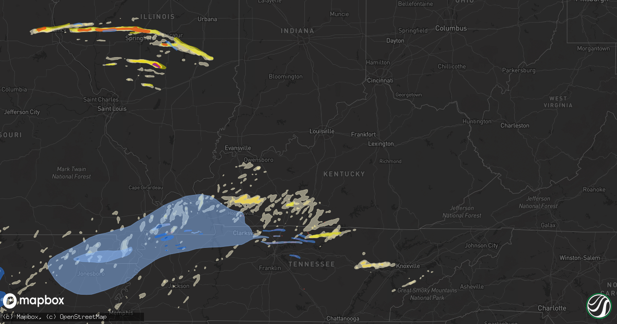
Hail Map in Kentucky on May 3, 2021
Get this storm
May 3 map
$229
one time, instant access
Download today. No call, no setup
Keep the $229
Bought the map and want the full workflow? Apply the entire $229 to a subscription within 7 days. None of it is wasted.
Every map, not just this one
This buys you this map. Subscription and you get every map we run, in the markets you choose from a few cities to whole states to nationwide. Plus real-time alerts the moment a storm fires.
Contact data
Name, contact info, occupancy, even credit band for addresses in the footprint. You go from where it hit to who to call.
Become the source they trust
Unlimited branding weather history reports on demand. You already have the documented answer ready for the property owner, and you are the one who showed up with it.
Property data and RoofTrace estimates
Pull up any address you have got, its value and the exact code rules for that jurisdiction, straight from One Click Code. Then RoofTrace estimates the squares, pitch, and roof value, priced the way you price.
Storm reports in Kentucky
Kentucky
| Date | Description |
|---|---|
| 05/03/20218:09 AM CDT | Multiple reports of numerous trees down as well as structural damage in tompkinsville along with power outages. Local media reports possible tornado. |
| 05/03/20218:08 AM CDT | Delayed report...storm damage survey found an ef1 tornado with peak winds of 95 mph. Maximum width was 60 yards and was on the ground for a half mile. Several trees upr |
| 05/03/20215:12 AM CDT | Tornado started just east of eagle way bypass and ft. Campbell blvd. Tracked for 2.6 miles with maximum width of 75 yards. At least 4 barns lost portions of their tin r |
| 05/03/20215:08 AM CDT | Tree down across both lanes of traffic on east 7th street at the 1700 block. |
| 05/03/20215:08 AM CDT | Tree... Power pole... And traffic lights down on fort campbell boulevard at the bypass. |
| 05/03/20215:00 AM CDT | Report of trees down in the burkesville city limits. |
| 05/03/20214:14 AM CDT | Late report. Several trees down... Roof blown of shop... Home flashing and roof damage. Time estimated from radar. |
| 05/03/20214:12 AM CDT | Numerous trees down from 2 miles west of hazel to hazel. 2 houses with trees on them. |
| 05/03/20214:10 AM CDT | Corrects timing of previous tstm wnd dmg report from burkesville. Report of trees down in the burkesville city limits. |
| 05/03/20214:03 AM CDT | Report from mping: trees down. |
| 05/03/20214:00 AM CDT | Shingles off roof and outbuilding damaged near tennessee state line. |
| 05/03/20214:00 AM CDT | Late report. Vinyl siding damaged. A few dozen trees down... Some large. |
| 05/03/20213:59 AM CDT | Occurred in rural farmland and wooded area. Minor to moderate roof damage to modern home. Several very large trees snapped and uprooted. Well head blown into a home... |
| 05/03/20213:55 AM CDT | Ef1 tornado started 2.5 miles southwest of cuba and traveled 5 miles and lifted around 4.25 miles southeast of cuba or near lynnville. Estimated peak winds at 95 mph an |
| 05/03/20213:40 AM CDT | Major structural damage to house. Roof and wall off house. Tree on house. Car moved 40 feet. Possible tornado. |
| 05/03/20213:38 AM CDT | Ef-2 tornado with peak winds of 125 mph struck fulton county early tuesday morning. One home was destroyed with its roof removed and some exterior walls knocked down. M |
| 05/03/20213:38 AM CDT | 3 buildings with wind damage. Power out. Large trees and power lines down. |
| 05/03/20213:36 AM CDT | Wind damage to a building in oakton. |
| 05/03/20213:30 AM CDT | Possible tornado. Damage extended from just southwest of oakton to the north side of clinton. Several trees on houses. Damage to trees and outbuildings. |
| 05/03/20213:29 AM CDT | An ef-1 tornado with estimated peak winds of 105 mph struck hickman county... Ky... Early tuesday morning. Multiple trees were snapped. Many tree branches and some enti |
| 05/03/202112:26 AM CDT | Trained spotter reported quarter size and some larger hail stones ongoing. |
| 05/03/202112:17 AM CDT | Trained spotter reported quarter size hail in bowling green ongoing. |
All States Impacted by Hail Map on May 3, 2021
Cities Impacted by Hail Map on May 3, 2021
- Princeton, KY
- Prague, OK
- Sparks, OK
- Covington, TX
- Azle, TX
- Fort Worth, TX
- Sadler, TX
- Gordonville, TX
- Gainesville, TX
- Whitesboro, TX
- Sherman, TX
- Howe, TX
- Scotland, AR
- Gatesville, TX
- Copperas Cove, TX
- Toledo, IL
- Lerna, IL
- Bells, TN
- Charleston, IL
- Crab Orchard, TN
- Jessieville, AR
- Hazen, AR
- Carlisle, AR
- Ennis, TX
- Gainesboro, TN
- Moss, TN
- Whitleyville, TN
- Hilham, TN
- Celina, TN
- Allons, TN
- Hemingway, SC
- Georgetown, SC
- Murrells Inlet, SC
- Allen, OK
- Tupelo, OK
- Stonewall, OK
- Fort Mitchell, AL
- Marietta, OK
- Thackerville, OK
- Conway, SC
- Chandler, OK
- Yale, OK
- Stillwater, OK
- Agra, OK
- Meeker, OK
- Carney, OK
- Tecumseh, OK
- Perkins, OK
- Wellston, OK
- Ripley, OK
- Cushing, OK
- Glencoe, OK
- Shawnee, OK
- Mcloud, OK
- Tryon, OK
- Pawnee, OK
- Hermleigh, TX
- Jbsa Lackland, TX
- San Antonio, TX
- La Vernia, TX
- Saint Hedwig, TX
- Adkins, TX
- Jbsa Ft Sam Houston, TX
- Marion, TX
- Converse, TX
- Seguin, TX
- Schertz, TX
- Justiceburg, TX
- Vian, OK
- Gore, OK
- Forrest City, AR
- Loop, TX
- Welch, TX
- Seagraves, TX
- Wills Point, TX
- Kyle, TX
- Maxwell, TX
- San Marcos, TX
- Colorado City, TX
- Ira, TX
- Evant, TX
- Johnson City, TX
- Round Mountain, TX
- Plains, TX
- Hillsboro, IL
- Brownsboro, TX
- Trinidad, TX
- Malakoff, TX
- Eustace, TX
- Mabank, TX
- Murchison, TX
- Athens, TX
- Ben Wheeler, TX
- Kemp, TX
- Clayton, IL
- Mount Sterling, IL
- Boerne, TX
- Kaufman, TX
- Crofton, KY
- White Plains, KY
- De Queen, AR
- Gillham, AR
- Trent, TX
- Loraine, TX
- Sweetwater, TX
- Coahoma, TX
- Roscoe, TX
- Westbrook, TX
- Snyder, TX
- Gail, TX
- Tioga, TX
- Collinsville, TX
- Waxahachie, TX
- Tyler, TX
- Lindale, TX
- Prattville, AL
- Cresson, TX
- Granbury, TX
- Chappells, SC
- Saluda, SC
- Ninety Six, SC
- Illiopolis, IL
- Buffalo, IL
- Mechanicsburg, IL
- Morgan, TX
- Hagarville, AR
- Lamar, AR
- Clarksville, AR
- Broken Bow, OK
- Mcalester, OK
- Moweaqua, IL
- Blue Mound, IL
- Dalton City, IL
- Macon, IL
- Stonington, IL
- Aubrey, TX
- Sulphur, OK
- Ardmore, OK
- Davis, OK
- Springer, OK
- Bethpage, TN
- Westmoreland, TN
- Barnesville, GA
- Glasgow, KY
- Dierks, AR
- Umpire, AR
- Marlin, TX
- Greenfield, IL
- Alvarado, TX
- Mattoon, IL
- Humboldt, IL
- Sullivan, IL
- Bunch, OK
- Havana, AR
- Marion, SC
- Mullins, SC
- Nichols, SC
- Hillsboro, TX
- Eastover, SC
- Hopkins, SC
- La Coste, TX
- Timewell, IL
- Calhoun, KY
- Rumsey, KY
- Benton, KY
- Burnet, TX
- Lampasas, TX
- Kempner, TX
- Italy, TX
- Milford, TX
- Red Oak, TX
- Wilmer, TX
- Palmer, TX
- Ferris, TX
- Lancaster, TX
- Lexington, SC
- Brownfield, TX
- Red Oak, OK
- Hickory, KY
- Quinton, OK
- Kinta, OK
- Wilburton, OK
- Itasca, TX
- Haslet, TX
- Springtown, TX
- Boyd, TX
- Weatherford, TX
- Decatur, TX
- Justin, TX
- Rhome, TX
- Newark, TX
- Pinopolis, SC
- Pocahontas, AR
- Imboden, AR
- Plumerville, AR
- Llano, TX
- Kingsland, TX
- Buchanan Dam, TX
- Lamesa, TX
- Earlsboro, OK
- Denver City, TX
- Tahoka, TX
- Odonnell, TX
- Tokio, TX
- Pigeon Forge, TN
- Sevierville, TN
- Springfield, AR
- Bee Branch, AR
- Center Ridge, AR
- Greenbrier, AR
- Damascus, AR
- Aledo, TX
- Breckenridge, TX
- Paducah, KY
- Rio Vista, TX
- Myrtle Beach, SC
- Milledgeville, GA
- Sparta, GA
- Hickman, KY
- Denton, TX
- Argyle, TX
- Litchfield, IL
- Butler, IL
- Raymond, IL
- Alexander City, AL
- Dadeville, AL
- Waverly, AL
- Camp Hill, AL
- Jacksons Gap, AL
- Belhaven, NC
- Stringtown, OK
- Lugoff, SC
- Temple, TX
- Meadow, TX
- Mitchell, GA
- Warthen, GA
- Versailles, IL
- Muenster, TX
- Mayfield, KY
- Devine, TX
- Castroville, TX
- Cleburne, TX
- Lake City, AR
- Carrollton, GA
- Franklin, GA
- Newnan, GA
- Stuart, OK
- Centreville, AL
- Lawley, AL
- Delaplaine, AR
- Biggers, AR
- Peach Orchard, AR
- Wister, OK
- Lonoke, AR
- Rule, TX
- Haskell, TX
- Canton, TX
- Rockwood, TN
- West Columbia, SC
- Gilbert, SC
- Timmonsville, SC
- Henderson, KY
- Owensboro, KY
- Robards, KY
- Gainesville, MO
- Isabella, MO
- Townsend, TN
- Gunter, TX
- Celina, TX
- Sanger, TX
- Pilot Point, TX
- Van Alstyne, TX
- Oliver Springs, TN
- Crossville, TN
- Oak Ridge, TN
- Harriman, TN
- Oakdale, TN
- McCaulley, TX
- Rotan, TX
- Stamford, TX
- Hamlin, TX
- Avoca, TX
- Anson, TX
- Lueders, TX
- Albany, TX
- Fulton, KY
- Hartsville, TN
- Lafayette, TN
- Mount Pleasant, AR
- Guion, AR
- Mico, TX
- Rio Medina, TX
- Grannis, AR
- Castalian Springs, TN
- Gallatin, TN
- Van Buren, AR
- Morrilton, AR
- Hattieville, AR
- Solgohachia, AR
- Waurika, OK
- Capitan, NM
- Bowling Green, KY
- Red Boiling Springs, TN
- Summer Shade, KY
- Holland, KY
- Etoile, KY
- Hestand, KY
- Eighty Eight, KY
- Mount Hermon, KY
- Burkesville, KY
- Tompkinsville, KY
- Gamaliel, KY
- Fountain Run, KY
- Scottsville, KY
- Sebree, KY
- Sardis, GA
- Waynesboro, GA
- Ringling, OK
- Wilson, OK
- Wichita Falls, TX
- Burkburnett, TX
- Calhoun Falls, SC
- Mercer, TN
- Denmark, TN
- Medon, TN
- London, AR
- Asher, OK
- Wanette, OK
- Macomb, OK
- Green Forest, AR
- Grand Rivers, KY
- Smithland, KY
- Meridian, OK
- Goodlettsville, TN
- Lometa, TX
- Abbeville, SC
- Nokomis, IL
- Ohlman, IL
- Morrisonville, IL
- Rosamond, IL
- Kiowa, OK
- Wardville, OK
- Lovington, IL
- Edinburg, IL
- Arthur, IL
- Bethany, IL
- Mt Zion, IL
- Walnut Ridge, AR
- Hoxie, AR
- Krum, TX
- Ponder, TX
- Prosper, TX
- Tom Bean, TX
- Whitewright, TX
- Valley View, TX
- Roby, TX
- Midlothian, TX
- New Braunfels, TX
- Kopperl, TX
- Mulberry Grove, IL
- Mena, AR
- Wickes, AR
- Vandervoort, AR
- Coalgate, OK
- Terrell, TX
- Charleston, MO
- East Prairie, MO
- Valley Mills, TX
- Tussy, OK
- Duncan, OK
- Ratliff City, OK
- Pipe Creek, TX
- Sherman, IL
- Atoka, OK
- Caney, OK
- Caddo, OK
- Kenefic, OK
- Coleman, OK
- Philadelphia, MO
- Coatsburg, IL
- Maywood, MO
- Taylor, MO
- Shelbyville, MO
- Camp Point, IL
- Ewing, MO
- Bethel, MO
- Durham, MO
- Quincy, IL
- Fowler, IL
- Emden, MO
- Newberry, SC
- Silverstreet, SC
- Dawson Springs, KY
- Waldron, AR
- Bradley, SC
- Greenwood, SC
- Elberton, GA
- Troy, SC
- Roswell, NM
- Rembert, SC
- Black Rock, AR
- Smithville, AR
- Powhatan, AR
- Byers, TX
- Petrolia, TX
- Ryan, OK
- Henrietta, TX
- Comer, GA
- Colbert, GA
- Hennepin, OK
- Dougherty, OK
- Mount Pulaski, IL
- Riverton, IL
- Niantic, IL
- Williamsville, IL
- Decatur, IL
- Beardstown, IL
- Virginia, IL
- Cantrall, IL
- Arenzville, IL
- Springfield, IL
- Ashland, IL
- Liberty, IL
- Athens, IL
- Tallula, IL
- Petersburg, IL
- Dixon Springs, TN
- Pleasant Shade, TN
- Coyle, OK
- Beech Grove, AR
- Tiptonville, TN
- Whites Creek, TN
- Joelton, TN
- Savanna, OK
- Ada, OK
- Haileyville, OK
- Wapanucka, OK
- Fittstown, OK
- Mccurtain, OK
- Centrahoma, OK
- Stratford, OK
- Elmore City, OK
- Keota, OK
- Pittsburg, OK
- Roff, OK
- Lone Grove, OK
- Tishomingo, OK
- Stigler, OK
- Fitzhugh, OK
- Hartshorne, OK
- Milburn, OK
- Blanco, OK
- Marlow, OK
- Krebs, OK
- Mill Creek, OK
- Graham, OK
- Maumelle, AR
- Pauls Valley, OK
- Pleasant Plains, IL
- Carlton, GA
- Crawford, GA
- Wynnewood, OK
- Eagletown, OK
- Winthrop, AR
- Haworth, OK
- Davisboro, GA
- Louisville, GA
- Blooming Grove, TX
- Eddy, TX
- Moody, TX
- Troy, TX
- Lott, TX
- Belton, TX
- Post, TX
- Lovington, NM
- Graham, TX
- Fluvanna, TX
- South Bend, TX
- Cross, SC
- Helotes, TX
- Stanton, TN
- Mason, TN
- Covington, TN
- Killeen, TX
- Fort Hood, TX
- Adams, TN
- Ackerly, TX
- Grandview, TX
- Walnut Springs, TX
- Iredell, TX
- Blum, TX
- Burleson, TX
- Joshua, TX
- Meridian, TX
- Cadiz, KY
- Quanah, TX
- Paducah, TX
- Jetson, KY
- Morgantown, KY
- Roundhill, KY
- Compton, AR
- Ponca, AR
- Crandall, TX
- Seagoville, TX
- Forney, TX
- Crawford, TX
- Smiths Grove, KY
- Shirley, AR
- Edgemont, AR
- Kingston, OK
- Lockesburg, AR
- Whitney, TX
- Godley, TX
- Maypearl, TX
- Keene, TX
- Venus, TX
- Girard, IL
- Waggoner, IL
- Harvel, IL
- Pana, IL
- Farmersville, IL
- Brierfield, AL
- Lewisburg, KY
- Bishopville, SC
- Lynchburg, SC
- Sumter, SC
- Lamar, SC
- Effingham, SC
- Mayesville, SC
- Crowley, TX
- Anna, TX
- Glen Rose, TX
- Rice, TX
- Clifton, TX
- Scurry, TX
- Forreston, TX
- Rainbow, TX
- Mansfield, TX
- Mertens, TX
- Mckinney, TX
- Bells, TX
- Dallas, TX
- Nemo, TX
- Bynum, TX
- Frost, TX
- Frisco, TX
- Rosser, TX
- Tolar, TX
- Barry, TX
- Cranfills Gap, TX
- Little Elm, TX
- Hutchins, TX
- Chatfield, TX
- Powell, TX
- Corsicana, TX
- Kerens, TX
- Utica, KY
- Dardanelle, AR
- Russellville, AR
- Perryton, TX
- Piedmont, AL
- Hatfield, AR
- Marion, AL
- Oakland, KY
- Ohatchee, AL
- Boswell, OK
- Hugo, OK
- Woodson, TX
- Jayton, TX
- Aspermont, TX
- Morton, TX
- Ralston, OK
- Millbrook, AL
- Montgomery, AL
- Valliant, OK
- Leslie, AR
- Big Spring, TX
- Seminole, TX
- Mount Olive, IL
- Gillespie, IL
- Shipman, IL
- Benld, IL
- Alma, AR
- Plano, TX
- Balko, OK
- Kennett, MO
- Holcomb, MO
- Bragg City, MO
- Avera, GA
- Scranton, SC
- Coward, SC
- Huntingdon, TN
- Jemison, AL
- Clanton, AL
- Gideon, MO
- Knobel, AR
- Batesburg, SC
- Leesville, SC
- Assumption, IL
- Taylorville, IL
- New Madrid, MO
- Peel, AR
- Protem, MO
- Lexington, TN
- Wildersville, TN
- Huron, TN
- Cedar Grove, TN
- Florence, SC
- Brownsville, KY
- Neelyville, MO
- Dry Branch, GA
- Hanson, KY
- Madisonville, KY
- Belton, KY
- Cerulean, KY
- Beech Creek, KY
- Nortonville, KY
- Dunmor, KY
- Hopkinsville, KY
- Elkton, KY
- Greenville, KY
- Paragould, AR
- Palmyra, IL
- Union City, TN
- Byrdstown, TN
- Pall Mall, TN
- Quitman, AR
- Concord, AR
- Drasco, AR
- Higden, AR
- Park City, KY
- Cave City, KY
- Maryville, TN
- Arlington, KY
- Bardwell, KY
- Grandin, MO
- McIntyre, GA
- Autaugaville, AL
- Coosada, AL
- Booth, AL
- Tallassee, AL
- Deatsville, AL
- Wetumpka, AL
- Shorter, AL
- Watson, OK
- Atascosa, TX
- Kendalia, TX
- Hondo, TX
- Dawson, TX
- Irving, IL
- Fancy Farm, KY
- Cunningham, KY
- Springfield, TN
- Pleasant View, TN
- Erin, TN
- Waverly, TN
- McEwen, TN
- Lone Oak, TX
- Campbell, TX
- Cumby, TX
- Sulphur Springs, TX
- Brashear, TX
- Livingston, TN
- Monroe, TN
- Vonore, TN
- Madisonville, TN
- Paradise, TX
- Dudley, MO
- Puxico, MO
- Luther, OK
- Rochester, KY
- Bull Shoals, AR
- Flippin, AR
- Daisy, OK
- Nesmith, SC
- Whitesburg, GA
- Donnellson, IL
- Walshville, IL
- Sorento, IL
- Panama, IL
- Seminole, OK
- Evening Shade, AR
- Parthenon, AR
- Longs, SC
- Dover, AR
- Cayce, SC
- Shaw Afb, SC
- Elliott, SC
- Monetta, SC
- Pamplico, SC
- Ward, SC
- Columbia, SC
- Gaston, SC
- Dalzell, SC
- Galivants Ferry, SC
- Ridge Spring, SC
- Salem, AL
- Russellville, KY
- Toomsboro, GA
- Sandersville, GA
- Deer Lodge, TN
- Moncks Corner, SC
- Jamestown, SC
- Cordesville, SC
- Bonneau, SC
- Huger, SC
- Sheppard Afb, TX
- Gilbertsville, KY
- Calvert City, KY
- Griggsville, IL
- Sylvester, TX
- Merkel, TX
- Maud, OK
- Atkins, AR
- Iowa Park, TX
- Maynard, AR
- Mountain Pine, AR
- Marbury, AL
- Batesville, AR
- Carrollton, TX
- Addison, TX
- Drummonds, TN
- Millington, TN
- Newhope, AR
- Hillsboro, GA
- Juliette, GA
- Forsyth, GA
- Jackson, TN
- Humboldt, TN
- Bigelow, AR
- Roland, AR
- Mayflower, AR
- Randlett, OK
- Wingo, KY
- Eddyville, KY
- Kuttawa, KY
- Purmela, TX
- Hamilton, TX
- Marshall, AR
- Castle, OK
- Wickliffe, KY
- Columbus, KY
- Clinton, KY
- Strawberry, AR
- Wellington, AL
- Mulberry, AR
- Madill, OK
- Matthews, MO
- Talihina, OK
- Brent, AL
- Montevallo, AL
- Randolph, AL
- Hettick, IL
- Spiro, OK
- Bokoshe, OK
- Pottsville, AR
- Heth, AR
- Widener, AR
- Byars, OK
- Gadsden, AL
- Jacksonville, AL
- Waverly Hall, GA
- Woodland, GA
- Huntsville, AR
- Witter, AR
- Aquilla, TX
- Pleasant Grove, AR
- Mountain View, AR
- Marcella, AR
- Prim, AR
- Doniphan, MO
- Clayton, AL
- Midway, AL
- Trementina, NM
- Gatewood, MO
- Couch, MO
- Myrtle, MO
- Ravenden, AR
- Omaha, GA
- Swainsboro, GA
- Gordon, GA
- Jeffersonville, GA
- Dexter, MO
- Bernie, MO
- Chapmansboro, TN
- Ashland City, TN
- Ethelsville, AL
- Reform, AL
- Stapleton, GA
- Kilbourne, IL
- Hartford, KY
- Leachville, AR
- Holdenville, OK
- Tallassee, TN
- Bremen, KY
- Boaz, KY
- Purdon, TX
- Water Valley, KY
- Yellville, AR
- White Hall, IL
- Carrollton, IL
- Horseshoe Bend, AR
- Cherokee Village, AR
- Franklin, AR
- Ash Flat, AR
- Vega, TX
- Adrian, GA
- Kite, GA
- Lockhart, TX
- Lamar, OK
- Sellers, SC
- Kathleen, GA
- Bonaire, GA
- Warner Robins, GA
- Alvaton, KY
- Knoxville, TN
- Slaughters, KY
- Martin, SC
- Hornsby, TN
- Cameron, OK
- Howe, OK
- Heavener, OK
- Poteau, OK
- Obion, TN
- Sunray, TX
- Frederick, IL
- Symsonia, KY
- Teachey, NC
- Wallace, NC
- Chapin, IL
- Bluffs, IL
- Martin, TN
- Dresden, TN
- Carlinville, IL
- Jacksonville, IL
- Meredosia, IL
- Cedar Hill, TN
- Cave City, AR
- Smithville, OK
- Tiline, KY
- Palmyra, MO
- Rushville, IL
- Marmaduke, AR
- Herndon, KY
- Brownsville, TN
- Orlinda, TN
- Qulin, MO
- Marion, KY
- Saint Charles, KY
- Sharon Grove, KY
- Sylacauga, AL
- Shelby, AL
- Columbiana, AL
- Stilwell, OK
- Memphis, TN
- Marion, AR
- Nebo, KY
- Ripley, TN
- Forestburg, TX
- Fillmore, IL
- Ridgely, TN
- Conway, AR
- Emory, TX
- Yantis, TX
- Sikeston, MO
- Blanco, TX
- Burna, KY
- Salem, KY
- Hanna, OK
- Eufaula, OK
- Dustin, OK
- Columbus, MS
- Flovilla, GA
- La Center, KY
- Rose Hill, NC
- Hye, TX
- Earlington, KY
- Floral, AR
- Rockfield, KY
- Mammoth Cave, KY
- Rocky Hill, KY
- Lucas, KY
- Cub Run, KY
- Clarksville, TN
- Ramsey, IL
- Witt, IL
- Bingham, IL
- Fredonia, KY
- Shiloh, GA
- Thomaston, GA
- Clinton, AR
- Greenville, TX
- Oglesby, TX
- Olmstead, KY
- Rector, AR
- Alvord, TX
- Island, KY
- Mount Judea, AR
- Pelsor, AR
- Newalla, OK
- England, AR
- Matador, TX
- Nashville, AR
- Mount Auburn, IL
- Ashmore, IL
- Westfield, IL
- Harristown, IL
- Lilbourn, MO
- Marston, MO
- Campbell, MO
- Malden, MO
- Hornbeak, TN
- Troy, TN
- Roland, OK
- Muldrow, OK
- Sulphur Rock, AR
- Alabaster, AL
- Pelham, AL
- Calera, AL
- Greenville, IL
- Talco, TX
- Sulphur Bluff, TX
- Franklin, KY
- Harrison, AR
- Marble Falls, AR
- Alpena, AR
- Cumberland Furnace, TN
- Vanleer, TN
- Cumberland City, TN
- Neoga, IL
- Gays, IL
- Adairville, KY
- Lead Hill, AR
- Omaha, AR
- Greenup, IL
- Trilla, IL
- Sidney, AR
- Robinsonville, MS
- Rosston, TX
- Era, TX
- Woodburn, KY
- Auburn, KY
- Edmonton, KY
- Beaumont, KY
- Medina, TN
- Oakfield, TN
- Ridgeville, SC
- Griffin, GA
- Milner, GA
- Livermore, KY
- Houston, AR
- Perryville, AR
- Granville, TN
- Hughes, AR
- Quinlan, TX
- Richardson, TX
- Buena Vista, TN
- Tennille, GA
- Dorchester, SC
- Theodosia, MO
- Hayti, MO
- Crawfordsville, AR
- Owaneco, IL
- Briggs, TX
- Shelbyville, IL
- Windsor, IL
- Findlay, IL
- Burneyville, OK
- Harrah, OK
- Modesto, IL
- Roodhouse, IL
- Jackson, GA
- West Paducah, KY
- Kevil, KY
- Melber, KY
- Iva, SC
- Due West, SC
- Hodges, SC
- Scranton, NC
- Newark, AR
- Rochester, IL
- Dawson, IL
- Gobler, MO
- Hornersville, MO
- Portageville, MO
- Henderson, TN
- Finger, TN
- Allen, TX
- Calvin, OK
- Lexington, GA
- Point, TX
- New Johnsonville, TN
- Eva, TN
- Austin, KY
- Norman, AR
- Baylis, IL
- Barry, IL
- Athens, GA
- Desoto, TX
- Salem, AR
- Sturkie, AR
- West Plains, MO
- Bono, AR
- Greenview, IL
- Clay, KY
- Scranton, AR
- Alpine, AL
- Talladega, AL
- Whitesboro, OK
- Muse, OK
- Honobia, OK
- Hodgen, OK
- Fayetteville, AR
- Springdale, AR
- Lipan, TX
- Stonewall, TX
- Cibolo, TX
- Mesquite, TX
- Chilton, TX
- Pottsboro, TX
- Charles Town, WV
- Ranson, WV
- Harpers Ferry, WV
- Knoxville, MD
- Atlanta, GA
- Clarkston, GA
- Tucker, GA
- Stone Mountain, GA
- Lithia Springs, GA
- Decatur, GA
- Douglasville, GA
- Lilburn, GA
- Snellville, GA
- Conyers, GA
- Monroe, GA
- Loganville, GA
- Lithonia, GA
- Winterville, GA
- Hull, GA
- Corona, NM
- Green Sea, SC
- Loris, SC
- La Grange, MO
- Paloma, IL
- Union Bridge, MD
- Walkersville, MD
- Frederick, MD
- New Market, MD
- New Windsor, MD
- Westminster, MD
- Mount Airy, MD
- Lottsburg, VA
- Callao, VA
- Oconee, IL
- Arcola, IL
- Coffeen, IL
- Smyrna, SC
- Graford, TX
- Edgewood, TX
- Alba, TX
- Grand Saline, TX
- Fruitvale, TX
- Caddo Mills, TX
- Klondike, TX
- Royse City, TX
- Ladonia, TX
- Pecan Gap, TX
- Cooper, TX
- Commerce, TX
- Mount Vernon, TX
- Como, TX
- Pickton, TX
- Saltillo, TX
- Chillicothe, TX
- Frederick, OK
- Vernon, TX
- Devol, OK
- Davidson, OK
- Electra, TX
- Grandfield, OK
- Oklaunion, TX
- Harrold, TX
- Avery, TX
- Annona, TX
- Hooks, TX
- Ashdown, AR
- Foreman, AR
- De Kalb, TX
- New Boston, TX
- Morrison, OK
- Pettigrew, AR
- Charleston, AR
- Winslow, AR
- Lavaca, AR
- Knoxville, AR
- Witts Springs, AR
- Combs, AR
- Tilly, AR
- Shady Point, OK
- Arkoma, OK
- Deer, AR
- Dennard, AR
- Pocola, OK
- Saint Joe, AR
- New Blaine, AR
- Hartman, AR
- Ratcliff, AR
- Ozark, AR
- Coal Hill, AR
- Cecil, AR
- Hector, AR
- Gans, OK
- Fort Smith, AR
- Rudy, AR
- Saint Paul, AR
- Barling, AR
- Vendor, AR
- Altus, AR
- Ozone, AR
- Paris, AR
- Oark, AR
- Jerusalem, AR
- Dyer, AR
- Mountainburg, AR
- Belleville, AR
- Cleveland, AR
- Subiaco, AR
- Danville, AR
- Ola, AR
- Booneville, AR
- Delaware, AR
- Pencil Bluff, AR
- Caddo Gap, AR
- Bismarck, AR
- Bonnerdale, AR
- Murfreesboro, AR
- Delight, AR
- Donaldson, AR
- Alexander, AR
- Royal, AR
- Pearcy, AR
- Story, AR
- Okolona, AR
- Sims, AR
- Hot Springs National Park, AR
- Lonsdale, AR
- Oden, AR
- Little Rock, AR
- Benton, AR
- Hot Springs Village, AR
- Kirby, AR
- Malvern, AR
- Amity, AR
- Glenwood, AR
- Mount Ida, AR
- Arkadelphia, AR
- Paron, AR
- Plainview, AR
- Barlow, KY
- Parma, MO
- Pembroke, KY
- Dell, AR
- Buchanan, TN
- Senath, MO
- Portia, AR
- Bumpus Mills, TN
- Kenton, TN
- Blytheville, AR
- Puryear, TN
- Big Sandy, TN
- Palmyra, TN
- Keiser, AR
- Manila, AR
- Alicia, AR
- Palmersville, TN
- Dexter, KY
- McKenzie, TN
- Gleason, TN
- Trenton, KY
- Big Rock, TN
- Gibson, MO
- Cord, AR
- Hardin, KY
- Newport, AR
- Trimble, TN
- Newbern, TN
- Weiner, AR
- Osceola, AR
- Lepanto, AR
- Brookport, IL
- Pollard, AR
- Murray, KY
- Greenway, AR
- Rutherford, TN
- Cardwell, MO
- Harrisburg, AR
- Cooter, MO
- Oak Grove, KY
- Clarkton, MO
- Corning, AR
- Ledbetter, KY
- Poughkeepsie, AR
- Cottage Grove, TN
- Brookland, AR
- Fisher, AR
- Bertrand, MO
- Lafe, AR
- Sedalia, KY
- Dyersburg, TN
- Catron, MO
- Stewart, TN
- Black Oak, AR
- Indian Mound, TN
- Metropolis, IL
- Caruthersville, MO
- State University, AR
- Caraway, AR
- Amagon, AR
- Greenbrier, TN
- Ravenden Springs, AR
- Arbyrd, MO
- Datto, AR
- Lynn, AR
- Jonesboro, AR
- Lenox, TN
- Swifton, AR
- Woodlawn, TN
- New Concord, KY
- Etowah, AR
- Cunningham, TN
- Charlotte, AR
- Wilson, AR
- Springville, TN
- Luxora, AR
- Greenfield, TN
- Finley, TN
- Saffell, AR
- South Fulton, TN
- Steele, MO
- Farmington, KY
- Bay, AR
- Tennessee Ridge, TN
- Tuckerman, AR
- Cash, AR
- Rives, TN
- Tyronza, AR
- Piggott, AR
- Saint Francis, AR
- Paris, TN
- Success, AR
- Gracey, KY
- La Fayette, KY
- Cherry Valley, AR
- Henry, TN
- Dyess, AR
- Monette, AR
- Dover, TN
- Anniston, MO
- Fort Campbell, KY
- Hazel, KY
- Almo, KY
- Marked Tree, AR
- Southside, TN
- Kirksey, KY
- Sharon, TN
- Dyer, TN
- Trumann, AR
- O'Kean, AR
- Dukedom, TN
- Halls, TN
- Wardell, MO
- Lebanon, TN
- Hendersonville, TN
- Portland, TN
- Cottontown, TN
- Cross Plains, TN
- Riddleton, TN
- Carthage, TN
- Mount Juliet, TN
- Watertown, TN
- Manchester, TN
- White House, TN


