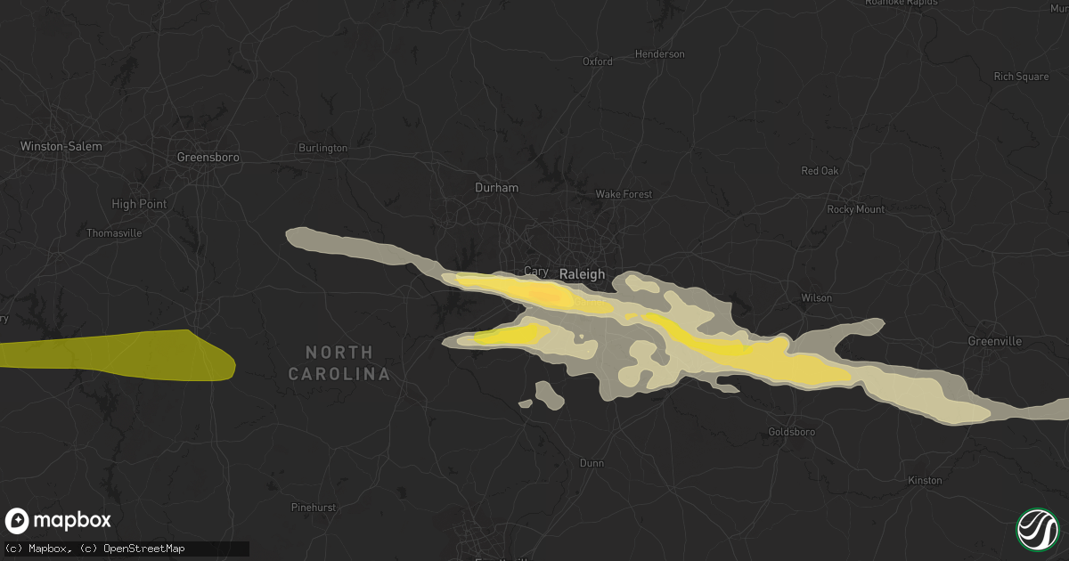
Hail Map in Cary, NC on May 3, 2016
Get this storm
May 3 map
$229
one time, instant access
Download today. No call, no setup
Keep the $229
Bought the map and want the full workflow? Apply the entire $229 to a subscription within 7 days. None of it is wasted.
Every map, not just this one
This buys you this map. Subscription and you get every map we run, in the markets you choose from a few cities to whole states to nationwide. Plus real-time alerts the moment a storm fires.
Contact data
Name, contact info, occupancy, even credit band for addresses in the footprint. You go from where it hit to who to call.
Become the source they trust
Unlimited branding weather history reports on demand. You already have the documented answer ready for the property owner, and you are the one who showed up with it.
Property data and RoofTrace estimates
Pull up any address you have got, its value and the exact code rules for that jurisdiction, straight from One Click Code. Then RoofTrace estimates the squares, pitch, and roof value, priced the way you price.
Storm reports in Cary, NC
Cary, NC
| Date | Description |
|---|---|
| 05/03/20165:15 PM CDT | Golf ball size hail in cary near tryon woods |
| 05/03/20165:13 PM CDT | Quarter sized hail reported near crossroads plaza |
| 05/03/20165:12 PM CDT | Quarter to dime size hail covering the ground |
| 05/03/20165:07 PM CDT | Quarter size hail at sw maynard and wicklow |
| 05/03/20165:04 PM CDT | Quarter size hail at tyron and highway 64 |
All States Impacted by Hail Map on May 3, 2016
All Cities Impacted by Hail Map on May 3, 2016
- Goose Creek, SC
- Four Oaks, NC
- Miami, FL
- Dunedin, FL
- Ridgeway, VA
- Martinsville, VA
- Axton, VA
- Cascade, VA
- Danville, VA
- Edison, GA
- Damascus, GA
- Arlington, GA
- Bluffton, GA
- Blakely, GA
- Garysburg, NC
- Chocowinity, NC
- Blounts Creek, NC
- Roanoke Rapids, NC
- Littleton, NC
- Cordele, GA
- Leesburg, GA
- Arabi, GA
- Smithville, GA
- De Soto, GA
- Pitts, GA
- Warwick, GA
- Wadesboro, NC
- Lilesville, NC
- Bonifay, FL
- Ayden, NC
- Grifton, NC
- Hookerton, NC
- Girard, GA
- Waynesboro, GA
- Hephzibah, GA
- Keysville, GA
- Martin, SC
- Tifton, GA
- Lakeland, GA
- Naylor, GA
- Graham, NC
- Liberty, NC
- Pittsboro, NC
- Snow Camp, NC
- Chapel Hill, NC
- Siler City, NC
- Brooklet, GA
- Pembroke, GA
- Lillington, NC
- Fuquay Varina, NC
- Angier, NC
- Raeford, NC
- Statesboro, GA
- Wilson, NC
- Morehead City, NC
- Urbanna, VA
- Lancaster, VA
- Farnham, VA
- Bruington, VA
- Saint Stephens Church, VA
- Water View, VA
- Weems, VA
- Little Plymouth, VA
- Warsaw, VA
- Heathsville, VA
- Laneview, VA
- Dunnsville, VA
- Tappahannock, VA
- Jamaica, VA
- Center Cross, VA
- King And Queen Court House, VA
- Church View, VA
- Kilmarnock, VA
- Whiteville, NC
- Smithfield, NC
- Jakin, GA
- Leary, GA
- Crystal River, FL
- Mount Olive, NC
- Faison, NC
- Denver, NC
- Sherrills Ford, NC
- Maiden, NC
- Terrell, NC
- Selma, NC
- Asheboro, NC
- Camilla, GA
- Sale City, GA
- Albany, GA
- Marston, NC
- Rockingham, NC
- Fremont, NC
- Lucama, NC
- Garner, NC
- Clayton, NC
- Kenly, NC
- Walstonburg, NC
- Farmville, NC
- Apex, NC
- Snow Hill, NC
- Pikeville, NC
- Raleigh, NC
- Princeton, NC
- Middlesex, NC
- Cary, NC
- Stantonsburg, NC
- Zebulon, NC
- Wendell, NC
- Willow Spring, NC
- Holly Springs, NC
- New Hill, NC
- Chipley, FL
- Bolton, NC
- Ambrose, GA
- Denton, GA
- Hazlehurst, GA
- Broxton, GA
- Wray, GA
- Fitzgerald, GA
- Chula, GA
- McRae Helena, GA
- Jacksonville, GA
- Pansey, AL
- Ashford, AL
- Gordon, AL
- Colquitt, GA
- Aylett, VA
- Newtown, VA
- Millen, GA
- Newton, NC
- La Grange, NC
- Newport, NC
- Polkton, NC
- Oriental, NC
- Merritt, NC
- Midville, GA
- Fairmont, NC
- Chadbourn, NC
- Hallsboro, NC
- Evergreen, NC
- Lake Waccamaw, NC
- Orrum, NC
- Deep Run, NC
- Albertson, NC
- Trenton, NC
- Kinston, NC
- Seven Springs, NC
- Dover, NC
- Quitman, GA
- Greenville, FL
- Charlotte, NC
- Sylvester, GA
- Doerun, GA
- Hartsfield, GA
- Sumner, GA
- Ty Ty, GA
- Moultrie, GA
- Pelham, GA
- Ellerbe, NC
- Sheldon, SC
- Seabrook, SC
- Wilmington, NC
- Winnabow, NC
- Leland, NC
- Monroe, NC
- Matthews, NC
- Denton, NC
- Yemassee, SC
- Ridgeland, SC
- Coosawhatchie, SC
- New London, NC
- Troy, NC
- Richfield, NC
- Gold Hill, NC
- Lexington, NC
- Salisbury, NC
- Coats, NC
- Port Saint Lucie, FL
- Tar Heel, NC
- Saint Pauls, NC
- Willard, NC
- Ivanhoe, NC
- Cove City, NC
- Ocilla, GA
- Swanquarter, NC
- Fayetteville, NC
- White Oak, NC
- Valdosta, GA
- Marshville, NC
- Indian Trail, NC
- Morgan, GA
- Dawson, GA
- Oakfield, GA
- Shellman, GA
- Knightdale, NC
- Moody Afb, GA
- Hahira, GA
- Council, NC
- Andrews, SC
- Cottageville, SC
- Round O, SC
- Okatie, SC
- Bluffton, SC
- Hardeeville, SC
- China Grove, NC
- Seagrove, NC
- Star, NC
- Rockwell, NC
- Exmore, VA
- Belle Haven, VA
- Teachey, NC
- Wallace, NC
- Hilton Head Island, SC
- Gaston, NC
- Tampa, FL
- Lumber City, GA
- Rhine, GA
- Dixie, GA
- Clermont, FL
- Windermere, FL
- Winter Garden, FL
- Groveland, FL
- Burgaw, NC
- Brooksville, FL
- Tallahassee, FL
- Lake Park, GA
- Caryville, FL
- Rocky Point, NC
- Stockton, GA
- Harrells, NC
- Crescent City, FL
- Georgetown, FL
- Claxton, GA
- Omega, GA
- Sims, NC
- Bailey, NC
- Elm City, NC
- Rocky Mount, NC
- Red Springs, NC
- Shannon, NC
- Mooresville, NC
- Catawba, NC
- Abbeville, GA
- Hope Mills, NC
- Lumber Bridge, NC
- Parkton, NC
- Palm Harbor, FL
- Poulan, GA
- Webster, FL
- Saint Helena Island, SC
- Baxley, GA
- Collins, GA
- Uvalda, GA
- Clarkton, NC
- Bladenboro, NC
- Campbellton, FL
- Cottonwood, AL
- Slocomb, AL
- Benson, NC
- Jackson, NC
- Monetta, SC
- Aiken, SC
- Green Pond, SC
- Randleman, NC
- Greensboro, NC
- Pleasant Garden, NC
- Donalsonville, GA
- Newton, GA
- Windsor, VA
- Suffolk, VA
- Lyons, GA
- Monticello, FL
- New Bern, NC
- Vanceboro, NC
- Ernul, NC
- Goldsboro, NC
- Enigma, GA
- Vernon, FL
- North, VA
- Dutton, VA
- Seaboard, NC
- Pleasant Hill, NC
- Boston, GA
- Vale, NC
- Hickory, NC
- Jamestown, SC
- Batesburg, SC
- Early Branch, SC
- Diggs, VA
- Moon, VA
- Moncure, NC
- West Union, IA
- Elgin, IA
- Rebecca, GA
- Scranton, NC
- Belhaven, NC
- Zuni, VA
- Garland, NC
- Elizabethtown, NC
- Lumberton, NC
- Delco, NC
- Onemo, VA
- Mathews, VA
- Walterboro, SC
- Louisville, GA
- Lane, SC
- Hartford, AL
- Fargo, GA
- Graceville, FL
- Salvo, NC
- Lloyd, FL
- Reidsville, GA
- Edisto Island, SC
- Lincolnton, NC
- Adel, GA
- Wagram, NC
- Ivor, VA
- Carrsville, VA
- Hoffman, NC
- Atkinson, NC
- Peachland, NC
- Laurinburg, NC
- Halifax, NC
- Westville, FL
- Grimesland, NC
- Greenville, NC
- Black Creek, NC
- Pine Level, NC
- Winterville, NC
- Fountain, NC
- Roseboro, NC
- Cobbs Creek, VA
- Hudgins, VA
- Leesville, SC
- Thomasville, NC
- Trinity, NC
- Ellabell, GA
- Boydton, VA
- Baskerville, VA
- Mount Gilead, NC
- Connelly Springs, NC
- Milan, GA
- Quincy, FL
- Midway, FL
- Cashton, WI
- La Crosse, WI
- Coon Valley, WI
- Genoa, WI
- Chaseburg, WI
- Viroqua, WI
- Bangor, WI
- Westby, WI
- Mount Ulla, NC
- Morganton, NC


