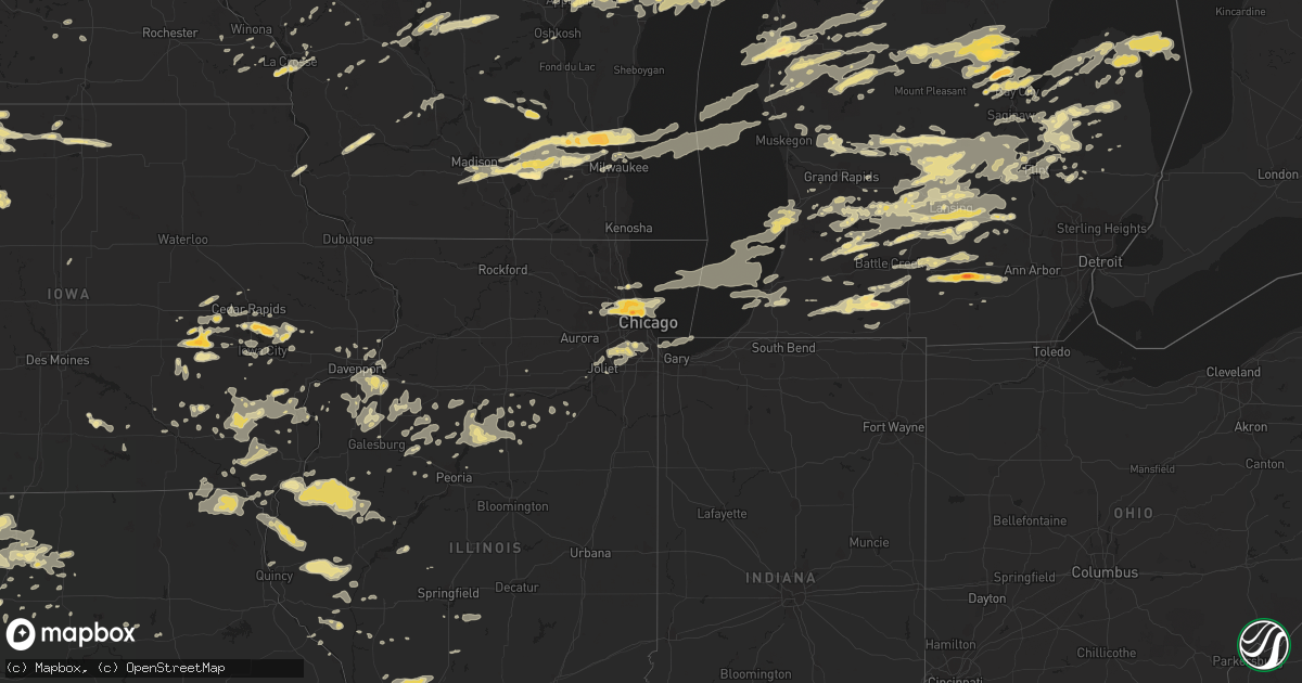
Hail Map in Iowa on May 3, 2012
Get this storm
May 3 map
$229
one time, instant access
Download today. No call, no setup
Keep the $229
Bought the map and want the full workflow? Apply the entire $229 to a subscription within 7 days. None of it is wasted.
Every map, not just this one
This buys you this map. Subscription and you get every map we run, in the markets you choose from a few cities to whole states to nationwide. Plus real-time alerts the moment a storm fires.
Contact data
Name, contact info, occupancy, even credit band for addresses in the footprint. You go from where it hit to who to call.
Become the source they trust
Unlimited branding weather history reports on demand. You already have the documented answer ready for the property owner, and you are the one who showed up with it.
Property data and RoofTrace estimates
Pull up any address you have got, its value and the exact code rules for that jurisdiction, straight from One Click Code. Then RoofTrace estimates the squares, pitch, and roof value, priced the way you price.
Storm reports in Iowa
Iowa
| Date | Description |
|---|---|
| 05/03/20126:35 PM CDT | Hail covering the ground. Hailed for about 12 minutes. |
| 05/03/20126:32 PM CDT | A local report indicates 1.00 inch wind near 8 N HUMBOLDT |
| 05/03/20126:23 PM CDT | Dime to quarter size hail |
| 05/03/20125:15 PM CDT | A local report indicates 1.00 inch wind near 4 NNE MASON CITY |
| 05/03/20125:12 PM CDT | Quarter size hail reported near the intersection of 330th and olive street. |
| 05/03/20125:01 PM CDT | A local report indicates 1.00 inch wind near 3 NNE MASON CITY AIRPOR |
| 05/03/20124:24 PM CDT | A local report indicates 1.00 inch wind near 1 N FOREST CITY |
| 05/03/20124:23 PM CDT | A local report indicates 1.00 inch wind near 1 ENE FOREST CITY |
| 05/03/20124:14 PM CDT | A local report indicates 1.75 inch wind near 4 WNW SWEA CITY |
| 05/03/20124:13 PM CDT | Also reported torrential rainfall. |
| 05/03/20123:02 PM CDT | A local report indicates 1.00 inch wind near 4 ESE BANCROFT |
| 05/03/20122:50 PM CDT | A local report indicates 1.00 inch wind near BANCROFT |
| 05/03/20122:30 PM CDT | A local report indicates 1.00 inch wind near W BANCROFT |
| 05/03/20125:38 AM CDT | Time estimated from radar. |
| 05/03/20123:38 AM CDT | Time estimated from radar. |
| 05/03/20123:03 AM CDT | Time estimated from radar. |
| 05/03/20122:34 AM CDT | Time estimated from radar. |
| 05/03/201212:10 AM CDT | Two large trees down |
| 05/03/201212:10 AM CDT | A local report indicates 1.00 inch wind near CONESVILLE |
| 05/02/201210:30 PM CDT | 4 large trees down at rock creek marina. One tree 30 inches in diameter fell on a motorhome. Another fell on a cabin deck. Time estimated by radar. |
| 05/02/201210:14 PM CDT | 60 to 70 mph wind gusts. Retired nws employee. |
| 05/02/201210:00 PM CDT | Two large trees down. Time estimated from radar. |
| 05/02/20129:27 PM CDT | A local report indicates 70 MPH wind near 2 E CENTERDALE |
| 05/02/20129:01 PM CDT | A local report indicates 60 MPH wind near E SOLON |
| 05/02/20128:55 PM CDT | Heavy damage at 3229 spruce ave about 4 miles northeast of wayland. Relayed by spotter. Time estimated. |
| 05/02/20128:55 PM CDT | Nickel to golf ball size hail fell for 17 minutes...ending at 855 pm |
| 05/02/20128:50 PM CDT | Tornado went over the residence at 2711 330th st about 2 miles northeast of wayland. Time estimated. Relayed 911 call from washington county sheriff office. |
| 05/02/20128:50 PM CDT | A local report indicates 1.75 inch wind near SOLON |
| 05/02/20128:45 PM CDT | A local report indicates 1.00 inch wind near AURELIA |
| 05/02/20128:44 PM CDT | Near 120th street near wayland. |
| 05/02/20128:43 PM CDT | A local report indicates 1.00 inch wind near AURELIA |
| 05/02/20128:39 PM CDT | A local report indicates 1.00 inch wind near AURELIA |
| 05/02/20128:31 PM CDT | A local report indicates 1.00 inch wind near NORWAY |
| 05/02/20128:23 PM CDT | 2-3 inch limbs down. Also had a lot of small hail...pea size or smaller |
| 05/02/20128:08 PM CDT | Golfball sized hail. |
| 05/02/20127:57 PM CDT | A local report indicates 1.25 inch wind near 5 E DAKOTA CITY |
| 05/02/20127:32 PM CDT | Quarter size hail lasted about 5 mintues. |
All States Impacted by Hail Map on May 3, 2012
Cities Impacted by Hail Map on May 3, 2012
- Hillview, IL
- Arbela, MO
- Luray, MO
- Kahoka, MO
- Mouth Of Wilson, VA
- Chesaning, MI
- Brant, MI
- Allegany, NY
- Dunlow, WV
- Genoa, WV
- Kiahsville, WV
- Louisa, KY
- Paintsville, KY
- Tomahawk, KY
- Fort Gay, WV
- Ulysses, KY
- Ranger, WV
- Boons Camp, KY
- River, KY
- Elsie, MI
- Owosso, MI
- Ovid, MI
- Seneca Falls, NY
- Savannah, NY
- Waterloo, NY
- Clyde, NY
- Le Sueur, MN
- Montgomery, MN
- Le Center, MN
- New Prague, MN
- Martinsville, MO
- Ridgeway, MO
- Albany, MO
- New Hampton, MO
- Denver, MO
- Gentry, MO
- Bethany, MO
- Rochester, TX
- Paducah, TX
- Aspermont, TX
- Rule, TX
- Weinert, TX
- Old Glory, TX
- Haskell, TX
- Brighton, IA
- Germantown, WI
- Mequon, WI
- Oconomowoc, WI
- Colgate, WI
- Hubertus, WI
- Rubicon, WI
- Hartland, WI
- Cedarburg, WI
- Richfield, WI
- Watertown, WI
- Neosho, WI
- Ashippun, WI
- Ixonia, WI
- Jackson, WI
- Hartford, WI
- Norris, SD
- Belington, WV
- Cedar Springs, MI
- Albion, MI
- Avoca, NY
- Hornell, NY
- Bath, NY
- Staunton, IL
- Worden, IL
- Livingston, IL
- New Douglas, IL
- Custer, MI
- Scottville, MI
- Ludington, MI
- Pentwater, MI
- Palos Park, IL
- Orland Park, IL
- Homer Glen, IL
- Lemont, IL
- Ithaca, NY
- Newfield, NY
- Oshkosh, WI
- Fall Creek, WI
- Hammondsport, NY
- Canisteo, NY
- Free Soil, MI
- Manistee, MI
- Cripple Creek, VA
- Ivanhoe, VA
- Fries, VA
- Otisville, MI
- Millington, MI
- Essexville, MI
- Bay City, MI
- Kawkawlin, MI
- Bancroft, NE
- Alma, NE
- Beaverton, MI
- Clare, MI
- Gladwin, MI
- Auburn, MI
- Midland, MI
- Sykesville, MD
- Woodbine, MD
- Howell, MI
- Casnovia, MI
- Sparta, MI
- Rockford, MI
- Kent City, MI
- Conklin, MI
- White River, SD
- Long Valley, SD
- Leonidas, MI
- Fulton, MI
- Mendon, MI
- Crawfordsville, IA
- Brownsville, MN
- Caledonia, MN
- La Crescent, MN
- Hokah, MN
- Rochester, NY
- Lennon, MI
- Durand, MI
- Mount Morris, MI
- Vernon, MI
- Swartz Creek, MI
- Flint, MI
- Corunna, MI
- Flushing, MI
- Wheeler, WI
- Wautoma, WI
- Friendship, WI
- Coloma, WI
- Hancock, WI
- Rhodes, MI
- Bentley, MI
- Woodland, PA
- Hamilton, MI
- Dorr, MI
- White Cloud, MI
- Big Rapids, MI
- Rodney, MI
- Chippewa Lake, MI
- Naponee, NE
- Republican City, NE
- Radford, VA
- Good Hope, IL
- Roseville, IL
- Lomax, IL
- Blandinsville, IL
- Macomb, IL
- Bushnell, IL
- Sciota, IL
- Raritan, IL
- Dallas City, IL
- Colchester, IL
- La Harpe, IL
- Barren Springs, VA
- Byron Center, MI
- Wayland, MI
- Forest City, IA
- Oregon, WI
- Decker, MI
- Snover, MI
- Sandusky, MI
- Bitely, MI
- Fort Atkinson, WI
- Jefferson, WI
- Ipava, IL
- Mount Pleasant, IA
- Wayland, IA
- Cambria, WI
- Williamston, MI
- Potterville, MI
- Lansing, MI
- Charlotte, MI
- Mason, MI
- Okemos, MI
- Dimondale, MI
- Holt, MI
- Boscobel, WI
- Muscoda, WI
- Richland Center, WI
- Blue River, WI
- Karthaus, PA
- Frenchville, PA
- Otter Lake, MI
- Fostoria, MI
- Columbiaville, MI
- North Branch, MI
- Gilman City, MO
- Manchester, KY
- Elmira, NY
- Horseheads, NY
- Cherokee, IA
- El Dorado, KS
- Minden City, MI
- Ubly, MI
- Waverly, NY
- Ollie, IA
- Linwood, MI
- Sterling City, TX
- Webberville, MI
- Fowlerville, MI
- Plainwell, MI
- Russell, IA
- Chariton, IA
- Hiawatha, KS
- Morrill, KS
- Wapello, IA
- Morning Sun, IA
- Farmington, IA
- De Pere, WI
- Denmark, WI
- Appleton, WI
- Combined Locks, WI
- Maribel, WI
- Kewaunee, WI
- Two Rivers, WI
- Kaukauna, WI
- Greenleaf, WI
- Menasha, WI
- Mishicot, WI
- Sutton, WV
- Birch River, WV
- Little Birch, WV
- Earlysville, VA
- Charlottesville, VA
- Spring Arbor, MI
- Jackson, MI
- Parma, MI
- Horton, MI
- Michigan Center, MI
- Manchester, MI
- Concord, MI
- Homer, MI
- Grass Lake, MI
- Olean, NY
- Rockport, IL
- Pittsfield, IL
- Kane, PA
- Pinconning, MI
- Lockridge, IA
- Lowell, MI
- Ada, MI
- Canandaigua, NY
- Vassar, MI
- Crystal, MI
- Carson City, MI
- Ithaca, MI
- Middleton, MI
- Sumner, MI
- Perrinton, MI
- Ashley, MI
- Wood, SD
- Dansville, MI
- Spring Mills, PA
- Colon, MI
- Sherwood, MI
- Barboursville, VA
- Keswick, VA
- King City, MO
- Sweet Springs, MO
- Oak Lawn, IL
- Alsip, IL
- Chicago Ridge, IL
- Black River Falls, WI
- Breesport, NY
- Erin, NY
- Lowman, NY
- Jasper, NY
- Cameron, NY
- Cameron Mills, NY
- Addison, NY
- Woodhull, NY
- Chula, MO
- Limestone, NY
- Gillett, PA
- Girard, PA
- Elkins, WV
- Keota, IA
- Eagle Rock, VA
- Boyceville, WI
- Eagle Pass, TX
- Bay City, WI
- Ellsworth, WI
- Osage City, KS
- Amana, IA
- Fairfax, IA
- Union City, MI
- Garden City, TX
- Agency, MO
- Armstrong, IA
- Swea City, IA
- Wayland, MO
- Wyaconda, MO
- Memphis, MO
- East Leroy, MI
- Athens, MI
- Rushford, MN
- Houston, MN
- Pretty Prairie, KS
- Andale, KS
- Wichita, KS
- Sedgwick, KS
- Maize, KS
- Colwich, KS
- Haven, KS
- Valley Center, KS
- Kechi, KS
- Mount Hope, KS
- Loganville, WI
- Hillpoint, WI
- Arkdale, WI
- Wild Rose, WI
- Redgranite, WI
- Nekoosa, WI
- Necedah, WI
- Stevensville, MI
- Saint Joseph, MI
- Oak Forest, IL
- Palos Heights, IL
- Wilton, WI
- Shipman, IL
- Gillespie, IL
- Brighton, IL
- Mount Olive, IL
- Bunker Hill, IL
- Piasa, IL
- Fennville, MI
- Holland, MI
- Saugatuck, MI
- Douglas, MI
- Chicago, IL
- Burlington, MI
- Howard, PA
- Aaronsburg, PA
- Millheim, PA
- Rebersburg, PA
- Madisonburg, PA
- Bellefonte, PA
- Woodward, PA
- Coburn, PA
- Homestead, IA
- Williamsburg, IA
- Burt, IA
- Andover, NY
- Madison, VA
- Rochelle, VA
- Aroda, VA
- Bedford, IA
- Clearfield, IA
- Blockton, IA
- Benton, IA
- Diagonal, IA
- Mondovi, WI
- Sheridan, MI
- Greenville, MI
- Sidney, MI
- Maiden Rock, WI
- Montrose, WV
- Rutland, IA
- Hardy, IA
- Livermore, IA
- Humboldt, IA
- Bode, IA
- Taylorville, IL
- Alkol, WV
- Griffithsville, WV
- Melrose, WI
- Martinsburg, WV
- Inwood, WV
- Gerrardstown, WV
- Swisher, IA
- Lake Mills, IA
- Leland, IA
- Lake Odessa, MI
- Woodland, MI
- Lakota, IA
- Bancroft, IA
- Titonka, IA
- Millmont, PA
- Milroy, PA
- Aurelia, IA
- Hastings, MI
- Middleville, MI
- Freeport, MI
- Twin Lake, MI
- Glade Hill, VA
- Rocky Mount, VA
- Jenison, MI
- Fenton, IA
- Ledyard, IA
- Ringsted, IA
- Beaver Dam, WI
- Iowa City, IA
- Tipton, IA
- Mechanicsville, IA
- Solon, IA
- West Branch, IA
- Donnellson, IA
- Fort Madison, IA
- Montrose, IA
- Victoria, IL
- Timewell, IL
- Camp Point, IL
- Clayton, IL
- Ruth, MI
- Stanton, NE
- Ainsworth, IA
- Washington, IA
- Clearfield, PA
- Owendale, MI
- Wyoming, MN
- Cedar, MN
- Bolivar, NY
- Little Genesee, NY
- East Moline, IL
- Geneseo, IL
- Silvis, IL
- Osco, IL
- Milan, IL
- Moline, IL
- Lynn Center, IL
- Colona, IL
- Sherrard, IL
- Coal Valley, IL
- Orion, IL
- Cambridge, IL
- Rock Island, IL
- Randolph, WI
- Pardeeville, WI
- Lake, MI
- Farwell, MI
- Harrison, MI
- Moravia, NY
- Auburn, NY
- Scipio Center, NY
- Union Springs, NY
- Grand Ridge, IL
- Ottawa, IL
- Potwin, KS
- Reedsburg, WI
- Baraboo, WI
- Eaton Rapids, MI
- Nashville, MI
- Olivet, MI
- Bellevue, MI
- Fayette, MO
- Coats, KS
- Van Etten, NY
- Bradford, PA
- Caro, MI
- Deford, MI
- Kingston, MI
- Hinsdale, NY
- Campbell, NY
- Alexander, NY
- East Bethany, NY
- Attica, NY
- Bannister, MI
- Fowler, MI
- Westphalia, MI
- Maple Rapids, MI
- Saint Johns, MI
- Pewamo, MI
- New Lothrop, MI
- Henderson, MI
- Alpine, NY
- Montour Falls, NY
- Odessa, NY
- Millport, NY
- Danville, IA
- Salem, IA
- Hillsboro, IA
- Bonaparte, IA
- Stockport, IA
- New London, IA
- Keosauqua, IA
- Charleston, WV
- Nitro, WV
- Frederick, MD
- Walkersville, MD
- Marengo, IA
- Bliss, NY
- Lake Mills, WI
- Helenville, WI
- Johnson Creek, WI
- Sullivan, WI
- Prairie Du Chien, WI
- McGregor, IA
- North Henderson, IL
- Rio, IL
- Alpha, IL
- New Windsor, IL
- Petersburg, IL
- Cadillac, MI
- Tustin, MI
- McBain, MI
- Niles, IL
- Park Ridge, IL
- Du Bois, PA
- Penfield, PA
- Elmwood, IL
- Yates City, IL
- Farmington, IL
- Batesland, SD
- Porcupine, SD
- Allen, SD
- Independence, VA
- Beattyville, KY
- Prairie Farm, WI
- Marienville, PA
- Centreville, MI
- Three Rivers, MI
- Marcellus, MI
- Coldwater, MI
- Bronson, MI
- Vicksburg, MI
- Jones, MI
- Chippewa Falls, WI
- Shelbyville, MI
- Martin, MI
- Caledonia, MI
- Hopkins, MI
- Mount Vernon, IA
- Coldwater, KS
- Utica, MN
- Lewiston, MN
- Deer Lodge, TN
- Darlington, MO
- Maysville, MO
- Pattonsburg, MO
- Guilford, MO
- Rea, MO
- Bolckow, MO
- McFall, MO
- Saegertown, PA
- Venango, PA
- Trenton, MO
- Saint Paul, MN
- Inver Grove Heights, MN
- Brockway, PA
- Lapeer, MI
- Saginaw, MI
- Montrose, MI
- Grand Ledge, MI
- East Lansing, MI
- Pigeon, MI
- Elkton, MI
- Portland, MI
- Sunfield, MI
- Hatfield, MO
- Eagleville, MO
- Bad Axe, MI
- Harbor Beach, MI
- Hickory Corners, MI
- Delton, MI
- Kalamazoo, MI
- Richland, MI
- Minneapolis, MN
- South Saint Paul, MN
- Mendota, MN
- Mount Sterling, IL
- Mio, MI
- Luzerne, MI
- Alta, IA
- Standish, MI
- Hope, MI
- Coleman, MI
- Sterling, MI
- Victor, NY
- Honeoye Falls, NY
- Gallatin, MO
- Toulon, IL
- Branchport, NY
- Keuka Park, NY
- Penn Yan, NY
- Pleasant Hill, IL
- Kerens, WV
- Wellsville, NY
- Alma, NY
- Port Hope, MI
- Garner, KY
- Driftwood, PA
- Yawkey, WV
- Spurlockville, WV
- Camden Point, MO
- Edgerton, MO
- Dearborn, MO
- Trimble, MO
- Ladora, IA
- Victor, IA
- Unionville, MI
- Sebewaing, MI
- Bartlett, IL
- Wayne, IL
- West Chicago, IL
- Granville, IL
- Orleans, NE
- Centre Hall, PA
- Williamson, WV
- Lenore, WV
- Kermit, WV
- Dingess, WV
- Breeden, WV
- Belfry, KY
- Zeeland, MI
- Pottersdale, PA
- Hedrick, IA
- Batavia, IA
- Spencer, NY
- Candor, NY
- Streator, IL
- Cornell, IL
- Blackstone, IL
- Ely, IA
- Keswick, IA
- Deep River, IA
- Manitowoc, WI
- Francis Creek, WI
- Mason City, IA
- Clear Lake, IA
- Garner, IA
- Ventura, IA
- Glenwood City, WI
- Ravenna, MI
- Filion, MI
- Kinde, MI
- Bay Port, MI
- Atkinson, IL
- Osceola, WI
- Staunton, VA
- Worth, IL
- Metamora, MI
- Mayville, MI
- North English, IA
- Adamstown, MD
- Dickerson, MD
- Corning, IA
- Lenox, IA
- Prescott, IA
- Brookville, PA
- Adair, IL
- Little Falls, MN
- Dixon, IA
- Walcott, IA
- Bloomfield, NY
- Bluffs, IL
- Stanley, WI
- Willard, WI
- Boyd, WI
- Augusta, WI
- Lyons, NY
- Phelps, NY
- Alhambra, IL
- Columbus Junction, IA
- Letts, IA
- Conesville, IA
- Leroy, MI
- Freeland, MI
- Stanton, MI
- Golden, IL
- West Point, IL
- Warsaw, IL
- Sutter, IL
- Loraine, IL
- Viper, KY
- Milwaukee, WI
- Philippi, WV
- Volga, WV
- Winfield, IA
- Prattsburgh, NY
- Pulteney, NY
- Royalton, MN
- Benezett, PA
- Emporia, KS
- Lacona, IA
- Eleva, WI
- Cohocton, NY
- Otsego, MI
- Cayuga, NY
- Port Byron, NY
- Newark, NY
- Montezuma, NY
- Webster, IA
- South English, IA
- La Crosse, WI
- Rexville, NY
- Whitesville, NY
- Orange, VA
- Essex, IA
- Glen Lyn, VA
- Princeton, WV
- Lewistown, IL
- Fenwick, MI
- Oskaloosa, IA
- Webster, NY
- Ontario, NY
- Long Point, IL
- Flanagan, IL
- Westport, PA
- Pender, NE
- Toddville, IA
- Hogansville, GA
- Greenville, GA
- Grantville, GA
- Chapin, IL
- Jacksonville, IL
- Chelsea, IA
- Slaterville Springs, NY
- Beaver Dams, NY
- Richford, NY
- Berkshire, NY
- Brooktondale, NY
- Cayuta, NY
- Galva, IL
- La Fayette, IL
- Gordonsville, VA
- Louisa, VA
- Painted Post, NY
- Bradford, NY
- Marine On Saint Croix, MN
- New Richmond, WI
- Star Prairie, WI
- Somerset, WI
- Scandia, MN
- Cedar Rapids, IA
- Atkins, IA
- Warfordsburg, PA
- Needmore, PA
- Traverse City, MI
- Mulliken, MI
- Vermontville, MI
- Kill Buck, NY
- Salamanca, NY
- Little Valley, NY
- Seymour, TX
- Throckmorton, TX
- Jamesport, MO
- Jameson, MO
- Dewitt, MI
- Des Plaines, IL
- Harwood Heights, IL
- Schiller Park, IL
- Franklin Park, IL
- Marshall, MI
- Springport, MI
- Deer Park, WI
- West Chester, IA
- Pratt, KS
- Weedsport, NY
- Nodaway, IA
- Gravity, IA
- Lock Haven, PA
- South Haven, MI
- Mcfarland, WI
- Stoughton, WI
- McDowell, VA
- Cowen, WV
- Marion, MI
- Evart, MI
- Luther, MI
- Reed City, MI
- Davison, MI
- Genoa, NE
- Silver Creek, NE
- Elmwood Park, IL
- Rock Port, MO
- Greene, NY
- Boelus, NE
- Dannebrog, NE
- Oak Grove, MO
- Harts, WV
- Varna, IL
- Lacon, IL
- Galesburg, IL
- Wataga, IL
- Palmer, NE
- Deckerville, MI
- Morley, MI
- Stanwood, MI
- Elk Mound, WI
- Brooklyn, IA
- Hartwick, IA
- Belle Plaine, IA
- Stanardsville, VA
- Rives Junction, MI
- Battle Creek, MI
- Pleasant Lake, MI
- Munith, MI
- Ceresco, MI
- Menomonie, WI
- Eau Claire, WI
- Toluca, IL
- La Rose, IL
- Henry, IL
- Washburn, IL
- Saint Charles, MN
- Woodhull, IL
- Oneida, IL
- Ophiem, IL
- Viola, IL
- Alexis, IL
- Kennard, NE
- Fremont, NE
- Arlington, NE
- Bennington, NE
- Valley, NE
- Whitelaw, WI
- Menomonee Falls, WI
- Saint Paul, NE
- Columbus City, IA
- Fairfield, IA
- Grandview, IA
- Union Hall, VA
- Wirtz, VA
- Frametown, WV
- Duck, WV
- Juneau, WI
- Concordia, MO
- Branch, MI
- Melrose Park, IL
- Skokie, IL
- Itasca, IL
- Bensenville, IL
- Evanston, IL
- River Grove, IL
- Addison, IL
- Lincolnwood, IL
- Wood Dale, IL
- Morton Grove, IL
- Clarksville, MI
- Alto, MI
- Fountain, MI
- Baldwin, MI
- Pewaukee, WI
- Delafield, WI
- Nashotah, WI
- Mount Vernon, KY
- Holliday, TX
- Forest Lake, MN
- Riverside, IA
- Mill Hall, PA
- Lamar, PA
- Swanville, MN
- Bowlus, MN
- Burtrum, MN
- Griggsville, IL
- Chambersburg, IL
- Baylis, IL
- Perry, IL
- Sheridan, MO
- Grant City, MO
- Hopkins, MO
- Redding, IA
- Cuba, NY
- Portville, NY
- Industry, IL
- Saint Albans, WV
- Troutdale, VA
- Elk Creek, VA
- West Salem, WI
- Winona, MN
- Lockport, IL
- Willow Springs, IL
- Midlothian, IL
- Palos Hills, IL
- Crestwood, IL
- Bridgeview, IL
- Hickory Hills, IL
- Blue Island, IL
- Oxford, IA
- New Market, IA
- Clarinda, IA
- Braddyville, IA
- Reedsville, WI
- Brillion, WI
- Walkerville, MI
- Dublin, VA
- Pulaski, VA
- Kalona, IA
- Huddleston, VA
- Idlewild, MI
- Northbrook, IL
- Sparland, IL
- Crawford, WV
- Wever, IA
- Niota, IL
- Joy, IL
- Ivor, VA
- Smithfield, VA
- French Creek, WV
- Wayland, NY
- Reynolds, IL
- Aledo, IL
- Matherville, IL
- Onondaga, MI
- Leslie, MI
- Falling Waters, WV
- Clear Spring, MD
- Bemus Point, NY
- Jamestown, NY
- Little Chute, WI
- Wrightstown, WI
- Kimberly, WI
- Forest Junction, WI
- Cantril, IA
- Milton, IA
- Hacker Valley, WV
- Selbyville, WV
- Rock Cave, WV
- Kanawha Head, WV
- Ireland, WV
- Cunningham, KS
- Carbon, IA
- Rome, PA
- Arcadia, MI
- Bear Lake, MI
- Huntington, WV
- Prichard, WV
- Kenova, WV
- Graettinger, IA
- Carrollton, GA
- Bates City, MO
- Glenarm, IL
- Auburn, IL
- Avon, IL
- Saint Augustine, IL
- Westby, WI
- Cashton, WI
- Dundee, NY
- Chillicothe, MO
- Big Cove Tannery, PA
- Sanford, MI
- Sears, MI
- Gobles, MI
- Altamont, MO
- Wisner, NE
- Eldridge, IA
- Long Grove, IA
- Van Horne, IA
- Vinton, IA
- Keystone, IA
- Pierz, MN
- Gerry, NY
- Speer, IL
- Linn Grove, IA
- Rembrandt, IA
- Chase, MI
- Red Creek, NY
- Lyons, MI
- Grey Eagle, MN
- Hart, MI
- Gowen, MI
- Tinley Park, IL
- Evergreen Park, IL
- Riverdale, IL
- Mokena, IL
- Belding, MI
- Dowling, MI
- Edinboro, PA
- Thompsonville, MI
- Okauchee, WI
- Waukesha, WI
- Cambridge, WI
- Sussex, WI
- Cottage Grove, WI
- Deerfield, WI
- Coin, IA
- Clearville, PA
- Reese, MI
- Marlette, MI
- Frankenmuth, MI
- Table Grove, IL
- Pawnee, IL
- Edinburg, IL
- Kincaid, IL
- Bulpitt, IL
- Tovey, IL
- Cameron, MO
- Stanberry, MO
- Conception Junction, MO
- Conception, MO
- O'Brien, TX
- Muir, MI
- Hubbardston, MI
- Wheeling, IL
- Stockbridge, MI
- Fox Lake, WI
- Fairgrove, MI
- Munger, MI
- Lindstrom, MN
- Shafer, MN
- Bardolph, IL
- Carthage, IL
- Marietta, IL
- Nauvoo, IL
- Orlando, KY
- Waverly, VA
- Elberon, VA
- Dendron, VA
- Marshall, WI
- Waterloo, WI
- Grafton, WI
- Lathrop, MO
- Plattsburg, MO
- Riner, VA
- Hiwassee, VA
- Joliet, IL
- Watkins, IA
- Waseca, MN
- Luzerne, IA
- Blairstown, IA
- Norway, IA
- Colfax, WI
- Knoxville, MD
- Wilmore, KS
- Haviland, KS
- Sawyer, KS
- Isabel, KS
- Hesperia, MI
- Shelby, MI
- Bowen, IL
- Basco, IL
- Hemlock, MI
- Merrill, MI
- West Point, IA
- Maryville, MO
- Skidmore, MO
- Burlington Junction, MO
- Parnell, MO
- Ravenwood, MO
- Pickering, MO
- Bettendorf, IA
- Le Claire, IA
- Davenport, IA
- Crystal City, TX
- Batesville, TX
- Mount Airy, MD
- Cooksville, MD
- Oneida, KY
- White Cloud, KS
- Buckhannon, WV
- Big Pool, MD
- Bath, MI
- Laingsburg, MI
- Cherry Tree, PA
- Westover, PA
- Eagle, MI
- Putnam, IL
- Tonica, IL
- Wenona, IL
- Magnolia, IL
- Chillicothe, IL
- Dana, IL
- McNabb, IL
- Lostant, IL
- Rutland, IL
- Carman, IL
- Stronghurst, IL
- Brooklyn, MI
- Onsted, MI
- Coffey, MO
- Boonsboro, MD
- Melrose, IA
- Lovilia, IA
- Pavilion, NY
- Highland Park, IL
- Glencoe, IL
- Deerfield, IL
- Interlochen, MI
- Roodhouse, IL
- White Hall, IL
- Strum, WI
- Osseo, WI
- Napier, WV
- Walkersville, WV
- Allegan, MI
- Parnell, IA
- New Boston, IL
- Williamsfield, IL
- Laura, IL
- Metamora, IL
- Freeville, NY
- Watkins Glen, NY
- Marathon, NY
- Dryden, NY
- Dryden, TX
- Madison, WI
- Cranesville, PA
- Albion, PA
- Willis, VA
- Dugspur, VA
- Ellendale, MN
- Owatonna, MN
- Whitehall, MI
- Montague, MI
- Tomah, WI
- Gassaway, WV
- Corning, NY
- Holton, MI
- Fremont, MI
- Tornado, WV
- Lone Rock, IA
- Algona, IA
- Woden, IA
- Kilbourne, IL
- Bath, IL
- Waterford, PA
- McKean, PA
- Saint Charles, MI
- Booneville, KY
- Dakota, MN
- Jerseyville, IL
- Gagetown, MI
- Akron, MI
- Paris, MI
- Hersey, MI
- Weidman, MI
- Barryton, MI
- Rothbury, MI
- Remus, MI
- New Era, MI
- Athens, PA
- Chelsea, MI
- Versailles, IL
- Fillmore, NY
- New Market, VA
- Timberville, VA
- Mount Jackson, VA
- Quicksburg, VA
- Eau Claire, MI
- Cass City, MI
- Ottumwa, IA
- Sodus Point, NY
- Marathon, TX
- Whitetop, VA
- Dowagiac, MI
- Benton, KS
- Sun City, KS
- Cheney, KS
- Kingman, KS
- Medicine Lodge, KS
- Newton, KS
- Turon, KS
- Arlington, KS
- London Mills, IL
- Maquon, IL
- Grand Blanc, MI
- Burton, MI
- Hedgesville, WV
- Mayville, NY
- Ashville, NY
- Sherman, NY
- Big Flats, NY
- Warrens, WI
- Addison, MI
- Quincy, IL
- Dresser, WI
- Creston, WV
- Coon Valley, WI
- Bangor, WI
- Shawnee, KS
- Lenexa, KS
- Hunt, NY
- Swain, NY
- Dalton, NY
- Draper, VA
- Creston, NC
- Lindley, NY
- Dawn, MO
- Barnard, MO
- Platte City, MO
- Marseilles, IL
- Robinson, KS
- Troutville, VA
- Roanoke, VA
- Blue Ridge, VA
- Thurston, NE
- Exchange, WV
- Burnsville, WV
- Clyde, MO
- Peterson, MN
- Stewartsville, MO
- Gower, MO
- Clear Lake, WI
- Troy, VA
- Benjamin, TX
- Altona, IL
- Gainesville, NY
- Castile, NY
- Clay, WV
- Diana, WV
- Webster Springs, WV
- Erbacon, WV
- Flatwoods, WV
- Elk Grove Village, IL
- Glendale Heights, IL
- Schaumburg, IL
- Mount Prospect, IL
- Arlington Heights, IL
- Medinah, IL
- Roselle, IL
- Bloomingdale, IL
- Beaver Springs, PA
- Stanley, NY
- Clifton Springs, NY
- Williamsport, MD
- Mercersburg, PA
- Portage, MI
- Schoolcraft, MI
- Sartell, MN
- Rice, MN
- Saint Stephen, MN
- Camp Douglas, WI
- Elroy, WI
- New Lisbon, WI
- Kendall, WI
- Perry, MI
- Haslett, MI
- Greenwood, NY
- Wolcott, NY
- Bradford, IL
- Neponset, IL
- Middleburg, PA
- Mount Pleasant Mills, PA
- Grawn, MI
- Buckley, MI
- Kingsley, MI
- Buffalo, MN
- Cushing, MN
- Princeville, IL
- Mount Solon, VA
- Weatherby, MO
- Galt, MO
- Union Star, MO
- Imlay City, MI
- Chautauqua, NY
- Vandalia, MI
- Chandlerville, IL
- Warrensville, NC
- Sidney, KY
- Varney, KY
- Pikeville, KY
- Ellamore, WV
- Dousman, WI
- Camanche, IA
- Albia, IA
- Long Prairie, MN
- Flensburg, MN
- Norton, WV
- Coalton, WV
- Byron, MI
- Hillsville, VA
- Parsons, WV
- Chesterfield, VA
- Churchville, NY
- Lewisburg, PA
- Mifflinburg, PA
- Saint Peter, MN
- Spring Run, PA
- Kilkenny, MN
- Greenfield, IL
- La Farge, WI
- Sodus, MI
- Mount Union, IA
- Barton, NY
- Washington, NE
- Arkport, NY
- Dansville, NY
- Canaseraga, NY
- Grayling, MI
- De Kalb, MO
- Braymer, MO
- Macedon, NY
- Shortsville, NY
- Ionia, NY
- Honeoye, NY
- Fairport, NY
- Lima, NY
- Rush, NY
- Farmington, NY
- Henrietta, NY
- Pittsford, NY
- Mendon, NY
- Minooka, IL
- Irons, MI
- Lake City, MI
- Verona, IL
- Mazon, IL
- Morris, IL
- Gardner, IL
- Dryden, MI
- Douglasville, GA
- Bloomingdale, MI
- Pine Valley, NY
- Bentley, KS
- Whitewater, KS
- Towanda, KS
- Swoope, VA
- Hennepin, IL
- Clio, MI
- Galesville, WI
- Illinois City, IL
- Newark Valley, NY
- Knox City, TX
- Oglesby, IL
- Sturgis, MI
- Burr Oak, MI
- Sayre, PA
- Columbia Cross Roads, PA
- Milan, PA
- Rose City, MI
- Port Byron, IL
- Hillsdale, IL
- Chemung, NY
- Slinger, WI
- Brookfield, WI
- Belleville, WI
- Mesick, MI
- Hamilton, MO
- Laceyville, PA
- Norfolk, NE
- Whitesburg, KY
- Isom, KY
- Premium, KY
- Jeremiah, KY
- Beemer, NE
- Homer, NY
- Lovely, KY
- Savona, NY
- Keedysville, MD
- Sharpsburg, MD
- Wakefield, VA
- Windsor, VA
- Mark, IL
- Myersville, MD
- Fairview, MI
- Grant, MI
- Bailey, MI
- Bishop Hill, IL
- Kewanee, IL
- Sunbright, TN
- Lyndon, KS
- Scranton, KS
- Silverwood, MI
- Aurora, NY
- Midkiff, WV
- Branchland, WV
- Sod, WV
- Montello, WI
- Mikado, MI
- Radcliffe, IA
- Ellsworth, IA
- Lisbon, IA
- North Liberty, IA
- North Freedom, WI
- Rock Springs, WI
- La Pryor, TX
- Clarksville, MO
- Horton, KS
- Welch, MN
- Red Wing, MN
- Bergen, NY
- Youngsville, PA
- Sugar Grove, PA
- Spring Valley, WI
- Luxemburg, WI
- Mendon, IL
- Alexandria, MO
- Keokuk, IA
- Ludlow, MO
- Utica, MO
- Eudora, KS
- Ricetown, KY
- Mistletoe, KY
- Turney, MO
- Holmen, WI
- Huntsville, MO
- Scio, NY
- Belmont, NY
- Ceres, NY
- Friendship, NY
- Eldred, PA
- Tiskilwa, IL
- Regina, KY
- Moneta, VA
- Mount Morris, NY
- Conesus, NY
- Geneseo, NY
- Broadway, VA
- Columbus, NE
- Williamson, NY
- West Liberty, IA
- Atalissa, IA
- Whitney Point, NY
- Lisle, NY
- Chenango Forks, NY
- Mayview, MO
- Cowgill, MO
- Polo, MO
- Quemado, TX
- Lakeville, NY
- Avon, NY
- Livonia, NY
- Palmyra, NY
- Marion, NY
- Walworth, NY
- Cortland, NY
- Groton, NY
- Lansing, NY
- Franklin, MO
- New Franklin, MO
- Palmyra, IL
- Peterson, IA
- Hamilton, KS
- Yarmouth, IA
- Sperry, IA
- Creston, IA
- Argyle, IA
- Kinsman, IL
- Seneca, IL
- Ransom, IL
- Bridgeport, MI
- Tekonsha, MI
- Keithsburg, IL
- Oakville, IA
- Dunlap, IL
- Hubbard Lake, MI
- Muskegon, MI
- Brown City, MI
- Brimfield, IL
- Earlville, IL
- Minonk, IL
- Benson, IL
- Sand Fork, WV
- Saint Joseph, MO
- Max Meadows, VA
- Loganton, PA
- Gibson, IA
- Kennedy, NY
- Caledonia, NY
- Lawton, MI
- Mattawan, MI
- Paw Paw, MI
- Ridgway, PA
- Beaver, KY
- Bypro, KY
- Bevinsville, KY
- Moravia, IA
- McKee, KY
- Montrose, MN
- Hudsonville, MI
- Trumansburg, NY
- Union Bridge, MD
- Melvin, MI
- Packwood, IA
- Sigourney, IA
- Richland, IA
- Benton Harbor, MI
- Coloma, MI
- Buda, IL
- Geneva, NY
- Pearisburg, VA
- Cottonwood Falls, KS
- Ionia, MI
- Bancroft, MI
- Pompeii, MI
- Birch Run, MI
- Sand Lake, MI
- Morrice, MI
- Burt, MI
- East Chicago, IN
- Dunbar, WV
- Merritt, MI
- Temple, GA
- Villa Rica, GA
- East Rochester, NY
- North Chili, NY
- Bloomington, NE
- Decatur, MI
- Hanover, MI
- Jonesville, MI
- Wanblee, SD
- Martin, SD
- Wyoming, NY
- Piffard, NY
- Dale, NY
- Leicester, NY
- Waterville, PA
- Jersey Shore, PA
- Wisconsin Dells, WI
- Port Austin, MI
- Fertile, IA
- Rock Falls, IA
- Britt, IA
- Nora Springs, IA
- Wesley, IA
- Manly, IA
- Fruitland, IA
- Muscatine, IA
- Durand, WI
- Hadley, MI
- Cassopolis, MI
- Rockford, MN
- Bennett, IA
- Clarence, IA
- Wyalusing, PA
- Le Raysville, PA
- Lowmansville, KY
- Woodlawn, VA
- Winston, MO
- Kidder, MO
- Eastern, KY
- Langley, KY
- Spencerport, NY
- Trivoli, IL
- Louisiana, MO
- Whiting, IN
- Hammond, IN
- Salisbury, MO
- Burnett, WI
- Princeton, WI
- Marion, IA
- Gregory, MI
- Eureka, KS
- Hemlock, NY
- Downing, WI
- Yeaddiss, KY
- Naples, NY
- Wyoming, IL
- De Soto, KS
- Nichols, NY
- Owego, NY
- Raymond, IL
- Harvel, IL
- West Springfield, PA
- Rocheport, MO
- Coralville, IA
- Tiffin, IA
- Kingston, MO
- Hortonville, WI
- Neenah, WI
- Belle Plaine, MN
- Staffordsville, VA
- Silver Springs, NY
- Warsaw, NY
- Crest Hill, IL
- Romeoville, IL
- New Berlin, WI
- Keytesville, MO
- Leonore, IL
- Fort Benning, GA
- Benzonia, MI
- Attica, MI
- Watervliet, MI
- Berrien Springs, MI
- Ontario, WI
- Norwalk, WI
- Alma, MI
- Fidelity, IL
- Randolph, NY
- Millersburg, IA


