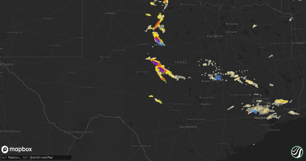
Hail Map in Texas on May 2, 2024
Get this storm
May 2 map
$229
one time, instant access
Download today. No call, no setup
Keep the $229
Bought the map and want the full workflow? Apply the entire $229 to a subscription within 7 days. None of it is wasted.
Every map, not just this one
This buys you this map. Subscription and you get every map we run, in the markets you choose from a few cities to whole states to nationwide. Plus real-time alerts the moment a storm fires.
Contact data
Name, contact info, occupancy, even credit band for addresses in the footprint. You go from where it hit to who to call.
Become the source they trust
Unlimited branding weather history reports on demand. You already have the documented answer ready for the property owner, and you are the one who showed up with it.
Property data and RoofTrace estimates
Pull up any address you have got, its value and the exact code rules for that jurisdiction, straight from One Click Code. Then RoofTrace estimates the squares, pitch, and roof value, priced the way you price.
Storm reports in Texas
Texas
| Date | Description |
|---|---|
| 05/02/20246:55 PM CDT | Storm chaser confirms tornado on the ground northeast of noodle. |
| 05/02/20246:45 PM CDT | Law enforcement relayed report from storm chaser on tornado on the ground northwest of doole. |
| 05/02/20246:42 PM CDT | Confirmed tornado on ground. |
| 05/02/20246:30 PM CDT | Concho park marina. Softball size hail. |
| 05/02/20246:30 PM CDT | Spotter confirmed tornado on ground. |
| 05/02/20246:29 PM CDT | Report from mping: baseball |
| 05/02/20246:26 PM CDT | Damage to vehicles and holes in metal awnings. |
| 05/02/20246:26 PM CDT | Spotter reported 3.5 inch size hail. |
| 05/02/20246:15 PM CDT | A local report indicates 3.00 inch wind near 1 E Ballinger |
| 05/02/20246:15 PM CDT | A local report indicates 1.00 inch wind near Anson |
| 05/02/20246:15 PM CDT | A local report indicates 2.75 inch wind near 2 WSW Leaday |
| 05/02/20246:02 PM CDT | Spotter reported a tornado on the ground 2 miles southeast of ballinger. |
| 05/02/20245:59 PM CDT | The public reported a tornado on the ground 2.3 miles east of ballinger... Moving east. |
| 05/02/20245:55 PM CDT | Spotter reported a tornado briefly touched down 5 miles northwest of anson. |
| 05/02/20245:43 PM CDT | Report from mping: quarter |
| 05/02/20245:43 PM CDT | On highway 83 tennis ball size. |
| 05/02/20245:32 PM CDT | Report from mping: tennis ball |
| 05/02/20245:31 PM CDT | Report from mping: hen egg+ |
| 05/02/20245:29 PM CDT | Report from mping: hen egg |
| 05/02/20245:28 PM CDT | Report from mping: half dollar |
| 05/02/20245:24 PM CDT | A local report indicates 1.00 inch wind near 7 S Guthrie |
| 05/02/20244:02 PM CDT | A local report indicates 1.00 inch wind near 3 NNE Bronte |
| 05/02/202411:05 AM CDT | Weatherflow station reported a 64 mph wind gust. |
| 05/02/202410:23 AM CDT | Strong thunderstorm wind gusts downed a large tree in a residential neighborhood of kingwood. |
| 05/02/20249:30 AM CDT | Social media pictures show downed trees and wooden fences damaged near imperial promenade drive and hwy 99. |
| 05/02/20249:03 AM CDT | Report of a fallen tree over a school bus as well as fences knocked down at birnham woods drive near elan blvd. |
| 05/02/20248:55 AM CDT | Trees blown down in the area and a commercial building has damage to a garage door. |
| 05/02/20248:53 AM CDT | Numerous trees down in nederland. |
| 05/02/20248:53 AM CDT | Photo of a tree and powerlines down on a flooded road. |
| 05/02/20248:23 AM CDT | Corrects previous tstm wnd dmg report from 1 ese kingwood. Strong thunderstorm wind gusts downed a large tree in a residential neighborhood of kingwood. |
| 05/02/20248:00 AM CDT | Half dollar size hail in kountze. Observed by hardin county emergency management coordinator. |
| 05/02/20245:12 AM CDT | Hardin county em submitted photos of quarter size hail in kountze. |
| 05/02/20243:55 AM CDT | Between 0.75 to 1 inch hail. |
| 05/02/20241:02 AM CDT | Report from mping: quarter |
| 05/02/202412:35 AM CDT | Ktpl awos measured 60 mph. 32041g52kt. |
| 05/01/20249:00 PM CDT | Relayed report. Radar estimated time. |
| 05/01/20248:37 PM CDT | Asos station kabi abilene. |
| 05/01/20248:08 PM CDT | Report from mping: grapefruit- |
| 05/01/20247:45 PM CDT | Report from mping: baseball |
| 05/01/20247:35 PM CDT | Property damage reported southwest of hawley on fm 605. |
| 05/01/20247:25 PM CDT | *** 2 inj *** report of home damaged with at least 2 injuries. |
| 05/01/20247:21 PM CDT | Tornado reported on the ground west of hawley. |
| 05/01/20247:13 PM CDT | Public reported baseball to softball size hail. |
| 05/01/20247:06 PM CDT | 277 just northwest of hawley. |
| 05/01/20247:05 PM CDT | Spotter reports confirmed tornado on the ground 4 to 5 miles west northwest of hawley. |
| 05/01/20247:00 PM CDT | Report from mping: baseball |
All States Impacted by Hail Map on May 2, 2024
Cities Impacted by Hail Map on May 2, 2024
- Akron, CO
- Yuma, CO
- Joes, CO
- Eckley, CO
- Vernon, CO
- Wray, CO
- Cleveland, TX
- Saratoga, TX
- Corydon, IA
- Kountze, TX
- Allerton, IA
- Lenexa, KS
- Shawnee, KS
- Spring, TX
- Tomball, TX
- Magnolia, TX
- Conroe, TX
- Liberty, TX
- Hull, TX
- Silsbee, TX
- Batson, TX
- Porter, TX
- Sour Lake, TX
- Waller, TX
- Hockley, TX
- New Caney, TX
- Pinehurst, TX
- Kingwood, TX
- Huffman, TX
- Humble, TX
- Cypress, TX
- Dayton, TX
- Orange, TX
- Beaumont, TX
- Nederland, TX
- Houston, TX
- Crosby, TX
- Port Neches, TX
- Groves, TX
- Port Arthur, TX
- Westmoreland, KS
- Baytown, TX
- Wallisville, TX
- Anahuac, TX
- Winnie, TX
- Severy, KS
- California, MO
- Jamestown, MO
- Cross Timbers, MO
- Rocheport, MO
- Franklin, MO
- Harrisburg, MO
- Clark, MO
- Warsaw, MO
- Edwards, MO
- Minooka, IL
- Shorewood, IL
- Plainfield, IL
- Joliet, IL
- Carl Junction, MO
- Columbia, MO
- Paris, MO
- Auxvasse, MO
- Oronogo, MO
- Mexico, MO
- Thompson, MO
- Fulton, MO
- Romeoville, IL
- Centertown, MO
- Lowpoint, IL
- Monroe City, MO
- Hunnewell, MO
- Metamora, IL
- Stoutsville, MO
- Peoria Heights, IL
- Peoria, IL
- Washington, IL
- East Peoria, IL
- Chicago, IL
- Washburn, IL
- Varna, IL
- Toluca, IL
- La Rose, IL
- Shelbina, MO
- Philadelphia, MO
- Lockport, IL
- Santa Fe, MO
- Burbank, IL
- Palmyra, MO
- Plymouth, IN
- Culver, IN
- Perry, MO
- Argos, IN
- Taylor, MO
- Center, MO
- Lohman, MO
- Jefferson City, MO
- Maywood, MO
- Quincy, IL
- Gary, IN
- Macomb, IL
- Elmwood, IL
- Bourbon, IN
- Hammond, IN
- Hannibal, MO
- Payson, IL
- Wooldridge, MO
- Hobart, IN
- Lake Station, IN
- Bardolph, IL
- Bushnell, IL
- Brimfield, IL
- Bremen, IN
- Hull, IL
- Portage, IN
- New Lenox, IL
- Nappanee, IN
- Bronte, TX
- Prairie City, IL
- Avon, IL
- Princeville, IL
- Edelstein, IL
- Speer, IL
- Liberty, IL
- Plainville, IL
- Barry, IL
- Etna Green, IN
- Milford, IN
- Ursa, IL
- Fowler, IL
- London Mills, IL
- Sparland, IL
- Clayton, IL
- Ellisville, IL
- New Paris, IN
- Littleton, IL
- Rushville, IL
- Coatsburg, IL
- Camp Point, IL
- Maquon, IL
- Industry, IL
- Vermont, IL
- Adair, IL
- Table Grove, IL
- Timewell, IL
- Syracuse, IN
- Fairview, IL
- Winters, TX
- Millersburg, IN
- Goshen, IN
- Yates City, IL
- Wingate, TX
- Norton, TX
- Ipava, IL
- Ligonier, IN
- Camden, IL
- Huntsville, IL
- Mount Sterling, IL
- Smithfield, IL
- Merkel, TX
- Plymouth, IL
- Topeka, IN
- Cuba, IL
- Lewistown, IL
- Colchester, IL
- Hamlin, TX
- Stamford, TX
- Anson, TX
- Rule, TX
- Canton, IL
- Paducah, TX
- Ballinger, TX
- Astoria, IL
- Dunlap, IL
- Marietta, IL
- Voss, TX
- Haskell, TX
- Farmington, IL
- Paint Rock, TX
- Chillicothe, IL
- Huntington, IN
- Columbia City, IN
- Talpa, TX
- Blackwell, TX
- Henry, IL
- Hinton, OK
- Weinert, TX
- Rochester, TX
- Lacon, IL
- Lookeba, OK
- Gouldbusk, TX
- Millersview, TX
- Magnolia, IL
- O'Brien, TX
- Knox City, TX
- Coleman, TX
- Hennepin, IL
- Munday, TX
- Doole, TX
- Roosevelt, TX
- Sonora, TX
- Seymour, TX
- Hawley, TX
- Lohn, TX
- Goree, TX
- Aspermont, TX
- Junction, TX
- Old Glory, TX
- Rockwood, TX
- Rowena, TX
- Abilene, TX
- Belleview, MO
- Rotan, TX
- Bismarck, MO
- Irondale, MO
- Caledonia, MO
- Rochelle, TX
- Santa Anna, TX
- Eden, TX
- Lueders, TX
- Albany, TX
- Melvin, TX
- Luther, OK
- Wellston, OK
- Crowell, TX
- Vernon, TX
- Clyde, TX
- Richland Springs, TX
- Chandler, OK
- Carney, OK
- Brady, TX
- San Saba, TX
- Chillicothe, TX
- Channahon, IL
- Elwood, IL
- Meeker, OK
- Mokena, IL
- Homer Glen, IL
- Willowbrook, IL
- Willow Springs, IL
- Bolingbrook, IL
- Hico, TX
- Hickory Hills, IL
- Justice, IL
- Bridgeview, IL
- Summit Argo, IL
- La Grange, IL
- Berwyn, IL
- Cicero, IL
- Palos Park, IL
- Orland Park, IL
- Palos Hills, IL
- Lemont, IL
- Iredell, TX
- Quanah, TX
- Oak Lawn, IL
- Jonesboro, TX
- Clifton, TX
- Meridian, TX
- Lyons, IL
- Inola, OK
- Broken Arrow, OK
- Hamilton, TX
- Lometa, TX
- Wagoner, OK
- Cranfills Gap, TX
- Chouteau, OK
- Coweta, OK
- Valera, TX
- Porter, OK
- Holdenville, OK
- Prague, OK
- Wetumka, OK
- Gatesville, TX
- Hulbert, OK
- Lamar, OK
- Dustin, OK
- Valley Mills, TX
- Locust Grove, OK
- Tahlequah, OK
- Fort Gibson, OK
- Mcalester, OK
- China Spring, TX
- Wewoka, OK
- Park Hill, OK
- Hanna, OK
- Fort Hood, TX
- Aquilla, TX
- Waco, TX
- Oglesby, TX
- Cookson, OK
- McGregor, TX
- Woodway, TX
- Moody, TX
- Muskogee, OK
- Temple, TX
- Welling, OK
- Indianola, OK
- Gore, OK
- Belton, TX
- Troy, TX
- Eddy, TX
- Bruceville, TX
- Lorena, TX
- Vian, OK
- Bunch, OK
- Chilton, TX
- Sallisaw, OK
- Hewitt, TX
- Lott, TX
- Marlin, TX
- Riesel, TX
- Rosebud, TX
- Muldrow, OK
- Quinton, OK
- Eufaula, OK
- Roland, OK
- Mart, TX
- Kosse, TX
- Thornton, TX
- Groesbeck, TX
- Macomb, OK
- Reagan, TX
- Wanette, OK
- Bremond, TX
- Konawa, OK
- Catoosa, OK
- Tulsa, OK
- Owasso, OK
- Van Buren, AR
- Fort Smith, AR
- Franklin, TX
- Claremore, OK
- Marquez, TX
- Wilburton, OK
- Jewett, TX
- Donie, TX
- Alma, AR
- Bay City, TX
- Buffalo, TX
- Talihina, OK
- Normangee, TX
- Madisonville, TX
- Charleston, AR
- Oakwood, TX
- Leona, TX
- Ada, OK
- Centerville, TX
- Cecil, AR
- Midway, TX
- Montgomery, TX
- Round Top, TX
- Brashear, TX
- Sulphur Springs, TX
- Wister, OK
- Katy, TX
- Allen, OK
- Roff, OK
- Whiting, IN
- Ledbetter, TX
- Watson, OK
- Smithville, OK
- Brookshire, TX
- Burton, TX
- Carmine, TX
- Crockett, TX
- Lovelady, TX
- Jacksonville, TX
- Richards, TX
- Willis, TX
- Trinity, TX
- Huntsville, TX
- Bellville, TX
- Stratford, OK
- Brenham, TX
- Henderson, TX
- Hempstead, TX
- Mena, AR
- Laneville, TX
- Washington, TX
- Navasota, TX
- Plantersville, TX
- Moscow, TX
- Corrigan, TX
- Mount Ida, AR
- Norman, AR
- Nashville, AR
- La Grange, MO
- Buna, TX
- Splendora, TX
- Elsberry, MO
- Foley, MO
- Troy, MO
- Winfield, MO
- Mendon, IL
- Laddonia, MO
- Murfreesboro, AR
- New Waverly, TX
- Bonnerdale, AR
- Royal, AR
- Pearcy, AR
- Hot Springs National Park, AR
- Texarkana, TX
- La Porte, TX
- Deer Park, TX
- Gurdon, AR
- Highlands, TX
- Malvern, AR
- Leola, AR
- Texarkana, AR
- Okolona, AR
- Fouke, AR
- Robert Lee, TX
- Robeline, LA


