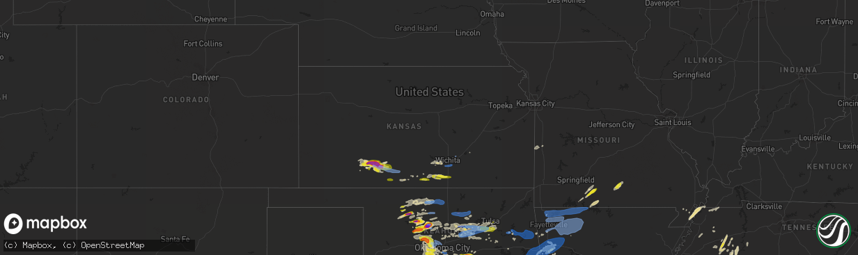
Hail Map in Kansas on May 2, 2022
The weather event in Kansas on May 2, 2022 includes Hail, Wind, and Tornado maps. 11 states and 499 cities were impacted and suffered possible damage. The total estimated number of properties impacted is 6,562.
Want more than just the map?
Turn this storm into a full workflow.
- Owner + property data so you know who to knock
- OnDemand branded weather history reports to win the "did we even have hail?" argument
- RoofTrace estimate so reps stop guessing numbers at the door
Bought this map? Upgrade within 7 days and we'll credit the $230. (10-15 min setup call)
Hail
Wind
Tornado
6,562
Estimated number of impacted properties by a 1.00" hail or larger1,074
Estimated number of impacted properties by a 1.75" hail or larger699
Estimated number of impacted properties by a 2.50" hail or largerStorm reports in Kansas
Kansas
| Date | Description |
|---|---|
| 05/02/20226:55 PM CDT | 6-12 inch diameter tree limbs down. |
| 05/02/20226:34 PM CDT | A local report indicates 60 MPH wind near 5 NE CLEARWATER |
| 05/02/20226:14 PM CDT | Report of 1.25 inch hail from kwch. |
| 05/02/20226:02 PM CDT | Report from mping: quarter |
| 05/02/20225:48 PM CDT | A local report indicates 1.00 inch wind near ARGONIA |
| 05/02/20223:46 PM CDT | Brief ground circulation from a landspout. It was observed by law enforcement and storm spotters. |
| 05/02/20223:34 PM CDT | Landspout tornado was reported. |
| 05/02/20223:25 PM CDT | Corrected with start location. Landspout observed by law enforcement and storm spotters. |
| 05/02/20223:25 PM CDT | Correction to the start location. This landspout was observed by law enforcement and storm spotters. It ended at 3:35 pm. |
| 05/02/20223:25 PM CDT | Corrects the previous report for protection. This landspout was observed by law enforcement and storm spotters. It ended at 3:35 pm. |
| 05/02/20223:06 PM CDT | A few golfball size hail stones but most were smaller. Time estimated by radar. |
| 05/02/20223:00 PM CDT | A local report indicates 1.75 inch wind near BUCKLIN |
| 05/02/20222:50 PM CDT | A local report indicates 1.00 inch wind near KINGSDOWN |
| 05/02/20222:50 PM CDT | A local report indicates 1.75 inch wind near 5 N BUCKLIN |
| 05/02/20222:30 PM CDT | Corrects previous hail report from 5 n bloom. A few golfball size hail stones but most were smaller. Time estimated by radar. |
| 05/02/20222:04 AM CDT | At 703 PM CDT, a severe thunderstorm was located near El Dorado, moving east at 30 mph. HAZARD...60 mph wind gusts and penny size hail. SOURCE...Radar indicated. IMPACT...Expect damage to roofs, siding, and trees. Locations impacted include... El Dorado, Eureka, Leon, Rosalia, Eureka City Lake, El Dorado Airport, Beaumont, El Dorado Lake, El Dorado State Park and Eureka Airport.This includes Interstate 35 between Mile Markers 69 and 76. |
| 05/02/20221:48 AM CDT | At 647 PM CDT, a severe thunderstorm was located near Towanda, moving east at 30 mph. HAZARD...60 mph wind gusts and penny size hail. SOURCE...Radar indicated. IMPACT...Expect damage to roofs, siding, and trees. Locations impacted include... El Dorado, Augusta, Towanda, Benton, Leon, El Dorado Airport, El Dorado Lake, El Dorado State Park and Santa Fe Lake.This includes Interstate 35 between Mile Markers 58 and 75. |
| 05/02/20221:26 AM CDT | At 626 PM CDT, a severe thunderstorm was located 6 miles southwest of Burbank, moving east at 40 mph. HAZARD...60 mph wind gusts and nickel size hail. SOURCE...Radar indicated. IMPACT...Expect damage to roofs, siding, and trees. Locations in or near the path include... Pawhuska... Fairfax... Shidler... Burbank... Grainola... Foraker... Pearsonia... Sunset Lake... Webb City... Apperson... |
| 05/02/20221:08 AM CDT | At 608 PM CDT, a severe thunderstorm was located near Goddard, moving east at 35 mph. HAZARD...60 mph wind gusts and quarter size hail. SOURCE...Radar indicated. IMPACT...Hail damage to vehicles is expected. Expect wind damage to roofs, siding, and trees. Locations impacted include... Wichita, Derby, Haysville, Park City, Bel Aire, Mulvane, Goddard, Maize, Clearwater, Garden Plain, Downtown Wichita, Kechi, Eastborough, West Wichita, East Wichita, Eisenhower National Airport, Northeast Wichita, Mcconnell Air Force Base, South Wichita and Oaklawn.This includes the following highways... Interstate 135 between Mile Markers 0 and 13. Interstate 35 between Mile Markers 35 and 52. |
| 05/02/202212:55 AM CDT | At 554 PM CDT, a severe thunderstorm was located near Argonia, or 7 miles south of Conway Springs, moving east at 35 mph. HAZARD...60 mph wind gusts and quarter size hail. SOURCE...Public reported quarter size hail near Argonia. IMPACT...Hail damage to vehicles is expected. Expect wind damage to roofs, siding, and trees. Locations impacted include... Wellington, Mulvane, Belle Plaine, Conway Springs, Oxford, Argonia, Mayfield, Milan, Perth, Riverdale and Wellington Airport.This includes Interstate 35 between Mile Markers 10 and 33. |
| 05/02/202212:35 AM CDT | At 535 PM CDT, severe thunderstorms were located along a line extending from 7 miles west of Hardy to Lake Carl Blackwell, moving east at 40 mph. HAZARD...60 mph wind gusts and quarter size hail. SOURCE...Radar indicated. IMPACT...Hail damage to vehicles is expected. Expect wind damage to roofs, siding, and trees. Locations in or near the path include... Pawnee... Fairfax... Shidler... Jennings... Ralston... Burbank... Hallett... Blackburn... Maramec... Skedee... Grainola... Foraker... Pearsonia... Webb City... Apperson... |
| 05/02/202212:31 AM CDT | At 531 PM CDT, a severe thunderstorm was located near Harper, moving east at 25 mph. HAZARD...60 mph wind gusts and quarter size hail. SOURCE...Radar indicated. IMPACT...Hail damage to vehicles is expected. Expect wind damage to roofs, siding, and trees. Locations impacted include... Anthony, Harper, Conway Springs, Argonia, Milan, Danville, Freeport and Runnymede. |
| 05/01/202210:45 PM CDT | At 344 PM CDT, severe thunderstorms were located along a line extending from near Ingersoll to 3 miles west of Aline, moving northeast at 30 mph. HAZARD...60 mph wind gusts and quarter size hail. SOURCE...Radar indicated. IMPACT...Hail damage to vehicles is expected. Expect wind damage to roofs, siding, and trees. Locations impacted include... Cherokee, Helena, Carmen, Wakita, Jet, Aline, Nash, Manchester, Amorita, Byron, Lambert, Ingersoll, Great Salt Plains Lake and Driftwood. |
| 05/01/202210:42 PM CDT | At 342 PM CDT, severe thunderstorms were located along a line extending from near Wellsford to near Buttermilk, moving east at 35 mph. HAZARD...70 mph wind gusts and quarter size hail. SOURCE...Radar indicated. IMPACT...Hail damage to vehicles is expected. Expect considerable tree damage. Wind damage is also likely to mobile homes, roofs, and outbuildings. Severe thunderstorms will be near... Haviland around 345 PM CDT. Wellsford around 350 PM CDT. Cullison around 400 PM CDT.Other locations in the path of these severe thunderstorms includePratt, Iuka and Aetna. |
| 05/01/202210:24 PM CDT | At 323 PM CDT, severe thunderstorms were located along a line extending from 4 miles east of Byron to 6 miles northwest of Ringwood, moving northeast at 35 mph. The largest hail is located with the storm west of Fairview. HAZARD...Ping pong ball size hail and 60 mph wind gusts. SOURCE...Radar indicated. IMPACT...People and animals outdoors will be injured. Expect hail damage to roofs, siding, windows, and vehicles. Expect wind damage to roofs, siding, and trees. Locations impacted include... Alva, Fairview, Cherokee, Helena, Carmen, Cleo Springs, Aline, Burlington, Dacoma, Amorita, Byron, Lambert, Orion, Orienta, Ingersoll, Isabella, Driftwood and Hopeton. |
| 05/01/202210:18 PM CDT | At 317 PM CDT, a severe thunderstorm was located 8 miles south of Bucklin, moving east at 35 mph. HAZARD...Golf ball size hail and 70 mph wind gusts. SOURCE...Radar indicated. IMPACT...People and animals outdoors will be injured. Expect hail damage to roofs, siding, windows, and vehicles. Expect considerable tree damage. Wind damage is also likely to mobile homes, roofs, and outbuildings. Locations impacted include... Wilmore. |
| 05/01/202210:02 PM CDT | At 301 PM CDT, severe thunderstorms were located along a line extending from 3 miles southwest of Avard to near Chester, moving northeast at 35 mph. HAZARD...60 mph wind gusts and quarter size hail. SOURCE...Radar indicated. IMPACT...Hail damage to vehicles is expected. Expect wind damage to roofs, siding, and trees. Locations impacted include... Alva, Fairview, Cherokee, Helena, Waynoka, Seiling, Carmen, Cleo Springs, Aline, Burlington, Dacoma, Amorita, Byron, Lambert, Orion, Chester, Avard, Orienta, Ingersoll and Isabella. |
| 05/01/20229:57 PM CDT | At 257 PM CDT, a severe thunderstorm was located near Bucklin, moving east at 35 mph. HAZARD...60 mph wind gusts and half dollar size hail. SOURCE...Radar indicated. IMPACT...Hail damage to vehicles is expected. Expect wind damage to roofs, siding, and trees. This severe thunderstorm will be near... Mullinville around 310 PM CDT.Other locations in the path of this severe thunderstorm includeGreensburg and Haviland. |
| 05/01/20229:26 PM CDT | At 226 PM CDT, a severe thunderstorm was located 7 miles north of Bloom, moving east at 25 mph. HAZARD...60 mph wind gusts and quarter size hail. SOURCE...Radar indicated. IMPACT...Hail damage to vehicles is expected. Expect wind damage to roofs, siding, and trees. This severe thunderstorm will be near... Bloom around 235 PM CDT.Other locations in the path of this severe thunderstorm include Ford,Kingsdown and Bucklin. |
All States Impacted by Hail Map on May 2, 2022
Cities Impacted by Hail Map on May 2, 2022
- Hume, MO
- Richards, MO
- Rich Hill, MO
- Watonga, OK
- Protem, MO
- Peel, AR
- Theodosia, MO
- Thornfield, MO
- Isabella, MO
- Milan, KS
- Caldwell, KS
- Argonia, KS
- Harper, KS
- Danville, KS
- Wellington, KS
- Mayfield, KS
- Halls, TN
- Gates, TN
- Brownsville, TN
- Ripley, TN
- Lexington, TN
- Lahoma, OK
- Enid, OK
- Hillsboro, AL
- Trinity, AL
- Blue Springs, MS
- Noble, OK
- Seminole, OK
- Drumright, OK
- Depew, OK
- Macomb, OK
- Tecumseh, OK
- Norman, OK
- Cushing, OK
- Agra, OK
- Stroud, OK
- Minor Hill, TN
- Goodspring, TN
- Prospect, TN
- Pulaski, TN
- Stillwater, OK
- Kinta, OK
- Lexington, OK
- Henrietta, TX
- Honobia, OK
- Willow Springs, MO
- Wichita Falls, TX
- El Reno, OK
- Belden, MS
- Tupelo, MS
- Poteau, OK
- Hartford, AR
- Howe, OK
- Mansfield, AR
- Hackett, AR
- Huntington, AR
- Okarche, OK
- Calumet, OK
- Fairview, OK
- Jacksboro, TX
- Perrin, TX
- Davis, OK
- Sulphur, OK
- Rienzi, MS
- Booneville, MS
- Chickasha, OK
- Ninnekah, OK
- Sharon, KS
- Wagoner, OK
- Porter, OK
- Medicine Lodge, KS
- West Fork, AR
- Prairie Grove, AR
- Canehill, AR
- Luray, TN
- Huron, TN
- Bonnerdale, AR
- Glenwood, AR
- Tuscumbia, AL
- Arcadia, OK
- Corinth, MS
- Walnut, MS
- Bowie, TX
- Bridgeport, TX
- Crump, TN
- Adamsville, TN
- Lavaca, AR
- Charleston, AR
- Holdenville, OK
- Atwood, OK
- Gainesville, TX
- Pearcy, AR
- Pauls Valley, OK
- Cyril, OK
- Cement, OK
- Anadarko, OK
- Jennings, OK
- Yale, OK
- Pond Creek, OK
- Stratford, OK
- Roff, OK
- Ada, OK
- Fitzhugh, OK
- Stonewall, OK
- Centrahoma, OK
- Allen, OK
- Tupelo, OK
- Coalgate, OK
- Kingfisher, OK
- Dover, OK
- Hennessey, OK
- Garden Plain, KS
- Goddard, KS
- Bayboro, NC
- Mill Creek, OK
- Ava, MO
- Guntown, MS
- Dumas, MS
- Baldwyn, MS
- Town Creek, AL
- Courtland, AL
- Minneola, KS
- Wynnewood, OK
- Bucklin, KS
- Ford, KS
- New Albany, MS
- Amber, OK
- Maud, OK
- Wewoka, OK
- Earlsboro, OK
- Union City, TN
- South Fulton, TN
- Sand Springs, OK
- Tulsa, OK
- Hollister, MO
- Shawnee, OK
- Princeton, AL
- Estillfork, AL
- Scottsboro, AL
- Guthrie, OK
- Edmond, OK
- Flintville, TN
- Ardmore, OK
- Springer, OK
- Dougherty, OK
- Apache, OK
- Yukon, OK
- Kiowa, OK
- Clayton, OK
- Pittsburg, OK
- Loyal, OK
- Taneyville, MO
- Kellyville, OK
- Bowlegs, OK
- Poolville, TX
- Hayti, MO
- Caruthersville, MO
- Tiptonville, TN
- Ridgely, TN
- Lawton, OK
- Saltillo, MS
- Morris Chapel, TN
- Guys, TN
- Michie, TN
- Selmer, TN
- Stantonville, TN
- Purcell, OK
- Lindsay, OK
- Quinton, OK
- Chester, OK
- Caddo Gap, AR
- Asher, OK
- Geronimo, OK
- Walters, OK
- Blue Mountain, MS
- Stumpy Point, NC
- Oklahoma City, OK
- Huntsville, AL
- Booneville, AR
- Iowa Park, TX
- Bellevue, TX
- Sheppard Afb, TX
- Ringling, OK
- Ryan, OK
- Bixby, OK
- Mounds, OK
- Glenpool, OK
- Sapulpa, OK
- Bristow, OK
- Mannford, OK
- Vanceboro, NC
- New Bern, NC
- Cove City, NC
- Linden, TN
- Okeene, OK
- El Dorado, KS
- Clearwater, KS
- Wichita, KS
- Cheney, KS
- Viola, KS
- Murdock, KS
- Mulberry, AR
- Dyer, AR
- Cecil, AR
- Alma, AR
- Fort Smith, AR
- Pocola, OK
- Ozark, AR
- Arkoma, OK
- Van Buren, AR
- Mountainburg, AR
- Spiro, OK
- Blanchard, OK
- Pawnee, OK
- Maramec, OK
- Cedar Grove, TN
- Pinson, TN
- Finger, TN
- Beech Bluff, TN
- Henderson, TN
- Jackson, TN
- Burneyville, OK
- Overbrook, OK
- Marietta, OK
- Steens, MS
- Columbus, MS
- Millport, AL
- Greensburg, KS
- Bradleyville, MO
- Humboldt, TN
- Scotts Hill, TN
- Saltillo, TN
- Bath Springs, TN
- Decaturville, TN
- Savannah, TN
- Sardis, TN
- Washington, OK
- Pontotoc, MS
- Carmen, OK
- Tishomingo, OK
- Sasakwa, OK
- Mullinville, KS
- Luther, OK
- Meridian, OK
- Muskogee, OK
- Braggs, OK
- Royal, AR
- Protection, KS
- Haviland, KS
- Dodge City, KS
- Natural Dam, AR
- Wayne, OK
- Maysville, OK
- Hitchcock, OK
- Omega, OK
- Tuttle, OK
- Minco, OK
- Wister, OK
- Elgin, OK
- Nash, OK
- Elmore City, OK
- Fittstown, OK
- Pilot Point, TX
- Valley View, TX
- Fletcher, OK
- Marlow, OK
- Wanette, OK
- Pocasset, OK
- Meno, OK
- Boynton, OK
- Morris, OK
- Ecru, MS
- Ripley, MS
- Chandler, OK
- Tryon, OK
- Wellston, OK
- Carney, OK
- Atoka, OK
- Macon, MS
- Aliceville, AL
- Calera, OK
- Thackerville, OK
- Whitesboro, TX
- Portageville, MO
- Crescent, OK
- Trenton, TN
- Bennington, OK
- Bokchito, OK
- Caddo, OK
- Leighton, AL
- Muscle Shoals, AL
- Union City, OK
- Perkins, OK
- Weatherford, TX
- Lipan, TX
- Granbury, TX
- Fort Worth, TX
- Azle, TX
- Helena, OK
- Houlka, MS
- Houston, MS
- Verden, OK
- Rush Springs, OK
- Mustang, OK
- Hodgen, OK
- Mulhall, OK
- Enville, TN
- Shiloh, TN
- Celina, TX
- Paoli, OK
- Cameron, OK
- Heavener, OK
- Nashoba, OK
- Stuart, OK
- Foster, OK
- Stringtown, OK
- Wardville, OK
- Daisy, OK
- Blanco, OK
- Branch, AR
- Norman, AR
- Wapanucka, OK
- Collinsville, TX
- Bentonville, AR
- Rogers, AR
- Cave Springs, AR
- Mccurtain, OK
- Attica, KS
- Anthony, KS
- Bison, OK
- Douglas, OK
- Alex, OK
- Checotah, OK
- Reagan, TN
- Mcloud, OK
- Newalla, OK
- Temple, OK
- Randlett, OK
- Colbert, OK
- Kingston, OK
- Durant, OK
- Madill, OK
- Cartwright, OK
- Mead, OK
- Sadler, TX
- Nocona, TX
- Konawa, OK
- Marshall, OK
- Coyle, OK
- Broken Arrow, OK
- Kiefer, OK
- Ripley, OK
- Piedmont, OK
- Duncan, OK
- Wheatland, OK
- Greenfield, OK
- Newcastle, OK
- Bradley, OK
- Geary, OK
- Ames, OK
- Drummond, OK
- Ringwood, OK
- Isabella, OK
- Gideon, MO
- Seymour, MO
- Pocahontas, TN
- Hennepin, OK
- Kennedy, AL
- Reform, AL
- Jet, OK
- Goltry, OK
- Forsyth, MO
- Branson, MO
- Red Oak, OK
- Deer, AR
- Calvin, OK
- Beggs, OK
- Okmulgee, OK
- Chadwick, MO
- Garrison, MO
- Oldfield, MO
- Vanzant, MO
- Summersville, MO
- Jenks, OK
- Medon, TN
- Greenwood, AR
- Shady Point, OK
- Somerville, AL
- Hartselle, AL
- Longdale, OK
- Fort Gibson, OK
- Talihina, OK
- Eva, AL
- Petrolia, TX
- Cherokee, OK
- Grantsboro, NC
- Coleman, OK
- Milburn, OK
- Holliday, TX
- Chico, TX
- Cleveland, OK
- Stilwell, OK
- Powder Springs, GA
- Marietta, GA
- Kennesaw, GA
- Fayette, AL
- Snow, OK
- Hickman, KY
- Winslow, AR
- Waynoka, OK
- Aline, OK
- Kremlin, OK
- Dacoma, OK
- Carrier, OK
- Okemah, OK
- Ernul, NC
- Milledgeville, TN
- Millsap, TX
- Springtown, TX
- Wilmore, KS
- Coldwater, KS
- Oxford, KS
- Vendor, AR
- Parthenon, AR
- Alpena, AR
- Western Grove, AR
- Wesley, AR
- Marble Falls, AR
- Fayetteville, AR
- Harrison, AR
- Combs, AR
- Pettigrew, AR
- Everton, AR
- Huntsville, AR
- Green Forest, AR
- Hasty, AR
- Ponca, AR
- Witter, AR
- Jasper, AR
- Elkins, AR
- Compton, AR
- Berryville, AR
- Kingston, AR
- Saint Paul, AR
- Omaha, AR
- Centerton, AR
- Oak Grove, AR
- Lead Hill, AR
- Lowell, AR
- Garfield, AR
- Eureka Springs, AR
- Hindsville, AR
- Springdale, AR
- Sun City, KS
- Peck, KS
- Haysville, KS
- Derby, KS
- Towanda, KS
- Benton, KS
- Lamont, OK
- Medford, OK
- Tonkawa, OK
- Hunter, OK
- Waukomis, OK
- Bethany, OK
- Perry, OK
- Morrison, OK
- Glencoe, OK
- Altus, AR
- Mcalester, OK
- Krebs, OK
- Lamar, OK
- Muldrow, OK
- Rudy, AR
- Midland, AR
- Mena, AR
- Barling, AR
- Waldron, AR
- Clarksville, AR
- Cedarville, AR
- Chester, AR
- Roland, OK
- Gans, OK
- Wilburton, OK
- Keota, OK
- Hartshorne, OK
- Bokoshe, OK
- Savanna, OK
- Sallisaw, OK
- Antlers, OK
- Tuskahoma, OK
- Bunch, OK
- Park Hill, OK
- Tahlequah, OK
- Cookson, OK
- Hulbert, OK
- Welling, OK
- Mountain Pine, AR
- Hot Springs National Park, AR


