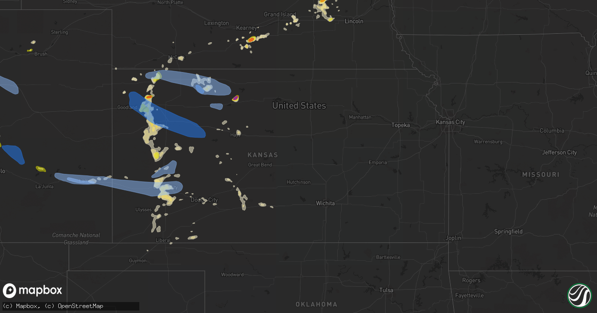
Hail Map in Kansas on May 2, 2021
Get this storm
May 2 map
$229
one time, instant access
Download today. No call, no setup
Keep the $229
Bought the map and want the full workflow? Apply the entire $229 to a subscription within 7 days. None of it is wasted.
Every map, not just this one
This buys you this map. Subscription and you get every map we run, in the markets you choose from a few cities to whole states to nationwide. Plus real-time alerts the moment a storm fires.
Contact data
Name, contact info, occupancy, even credit band for addresses in the footprint. You go from where it hit to who to call.
Become the source they trust
Unlimited branding weather history reports on demand. You already have the documented answer ready for the property owner, and you are the one who showed up with it.
Property data and RoofTrace estimates
Pull up any address you have got, its value and the exact code rules for that jurisdiction, straight from One Click Code. Then RoofTrace estimates the squares, pitch, and roof value, priced the way you price.
Storm reports in Kansas
Kansas
| Date | Description |
|---|---|
| 05/02/20216:55 PM CDT | Awos station k3k3 syracuse. |
| 05/02/20216:48 PM CDT | 3/8 inch hail and .75 inches of rain. |
| 05/02/20216:43 PM CDT | Spotter reported pea to quarter sized hail with heavy rain and wind gusts of 40-50 mph. |
| 05/02/20216:37 PM CDT | Hail visible on highway camera at bow creek bridge. Estimated to be around quarter size. |
| 05/02/20216:35 PM CDT | Delayed report from social media of quarter sized hail in bird city. |
| 05/02/20216:34 PM CDT | Near zero visibility due to blowing dust. |
| 05/02/20216:21 PM CDT | Also reported near zero visibility due to blowing dust. |
| 05/02/20216:20 PM CDT | Off duty nws employee reports dime to quarter size hail. |
| 05/02/20216:15 AM CDT | At 1114 PM CDT, severe thunderstorms were located along a line extending from near Dillwyn to near Sun City, moving east at 30 mph. HAZARD...60 mph wind gusts and nickel size hail. SOURCE...Radar indicated. IMPACT...Expect damage to roofs, siding, and trees. Locations impacted include... Pratt, Medicine Lodge, St. John, Stafford, Iuka, Preston, Sawyer, Cullison, Isabel, Coats, Lake City, Sun City, Byers, Zenith, Cairo and Neola. |
| 05/02/20215:59 AM CDT | At 1057 PM CDT, severe thunderstorms were located along a line extending from Luray to near Wilson to near Claflin to near Great Bend, moving east to southeast at 40 mph. HAZARD...60 to 70 mph wind gusts. SOURCE...Radar indicated. IMPACT...Expect considerable tree damage. Damage is likely to mobile homes, roofs, and outbuildings. Locations impacted include... Great Bend, Russell, Lyons, Ellsworth, Hoisington, Sterling, Ellinwood, Wilson, Claflin, Kanopolis, Lincoln, Little River, Chase, Holyrood, Lucas, Gorham, Bushton, Sylvan Grove, Geneseo and Pawnee Rock.This includes Interstate 70 between Mile Markers 176 and 235.This storm has a history of producing 85 mph winds in Russell! |
| 05/02/20215:41 AM CDT | At 1040 PM CDT, a severe thunderstorm was located 7 miles north of Greensburg, moving east at 45 mph. HAZARD...60 mph wind gusts and nickel size hail. SOURCE...Radar indicated. IMPACT...Expect damage to roofs, siding, and trees. Locations impacted include... Pratt, Greensburg, Haviland, Macksville, Mullinville, Iuka, Cullison, Coats, Byers, Fellsburg, Hopewell, Wellsford, Croft, Centerview and Trousdale. |
| 05/02/20215:19 AM CDT | At 1019 PM CDT, severe thunderstorms were located along a line extending from near Walker to near Gray, moving southeast at 35 mph. HAZARD...60 mph wind gusts and penny size hail. SOURCE...Radar indicated. IMPACT...Expect damage to roofs, siding, and trees. Locations impacted include... La Crosse, Victoria, Walker, Otis, Bison, Burdett, Rush Center, Rozel, Liebenthal, Timken, Ash Valley, Sanford, Loretta, Nekoma, Frizell, Hargrave, Pfeifer and Shaffer. |
| 05/02/20215:01 AM CDT | At 1000 PM CDT, severe thunderstorms were located along a line extending from near Emmeram to Hargrave to 8 miles southeast of Ness City, moving southeast at 45 mph. HAZARD...60 mph wind gusts. SOURCE...Radar indicated. IMPACT...Expect damage to roofs, siding, and trees. Locations impacted include... Great Bend, Russell, Hoisington, Ellinwood, Wilson, Claflin, Lucas, Gorham, Pawnee Rock, Luray, Dorrance, Albert, Olmitz, Milberger, Bunker Hill, Paradise, Galatia, Susank, Waldo and Great Bend Airport.This includes Interstate 70 between Mile Markers 176 and 205. |
| 05/02/20214:45 AM CDT | At 945 PM CDT, severe thunderstorms were located along a line extending from near Hildreth to Kensington to 9 miles north of Yocemento, moving east at 35 mph. HAZARD...60 mph wind gusts and penny size hail. SOURCE...Radar indicated. IMPACT...Expect damage to roofs, siding, and trees. Locations impacted include... Phillipsburg, Plainville, Smith Center, Osborne, Stockton, Red Cloud, Franklin, Blue Hill, Downs, Kensington, Hildreth, Campbell, Natoma, Agra, Bladen, Lebanon, Kirwin, Republican City, Upland and Woodston. |
| 05/02/20214:42 AM CDT | At 942 PM CDT, severe thunderstorms were located along a line extending from near Ellis to near Arnold, moving southeast at 45 mph. HAZARD...60 mph wind gusts and nickel size hail. SOURCE...Radar indicated. IMPACT...Expect damage to roofs, siding, and trees. Locations impacted include... Hays, Ellis, Ness City, La Crosse, Victoria, Walker, Bazine, Catherine, Ransom, Schoenchen, McCracken, Ogallah, Utica, Liebenthal, Alexander, Brownell, Emmeram, Yocemento, Nekoma and Hargrave. |
| 05/02/20214:23 AM CDT | At 922 PM CDT, severe thunderstorms were located along a line extending from 4 miles north of Voda to Nicodemus, moving east at 15 mph. HAZARD...60 mph wind gusts. SOURCE...Weather Instrument at Hill City. IMPACT...Expect damage to roofs, siding, and trees. Severe thunderstorms will be near... Bogue and Nicodemus around 930 PM CDT. |
| 05/02/20214:14 AM CDT | At 914 PM CDT, severe thunderstorms were located along a line extending from 7 miles south of Collyer to near Healy, moving southeast at 30 mph. HAZARD...60 mph wind gusts. SOURCE...Radar indicated. IMPACT...Expect damage to roofs, siding, and trees. These severe thunderstorms will remain over mainly rural areas of Gove County, including the following locations... The Monument Rocks.This includes Interstate 70 in Kansas between mile markers 105 and112. |
| 05/02/20213:43 AM CDT | At 842 PM CDT, severe thunderstorms were located along a line extending from 9 miles northwest of Almena to 5 miles southwest of Edmond, moving east at 15 mph. These are very dangerous storms. HAZARD...80 mph wind gusts. SOURCE...Weather Instruments. IMPACT...Flying debris will be dangerous to those caught without shelter. Mobile homes will be heavily damaged. Expect considerable damage to roofs, windows, and vehicles. Extensive tree damage and power outages are likely. Severe thunderstorms will be near... Edmond around 855 PM CDT.Other locations in the path of these severe thunderstorms includeAlmena. |
| 05/02/20213:39 AM CDT | At 839 PM CDT, severe thunderstorms were located along a line extending from near Amy to 15 miles east of Friend, moving east at 25 mph. HAZARD...60 mph wind gusts and nickel size hail. SOURCE...Radar indicated. IMPACT...Expect damage to roofs, siding, and trees. Locations impacted include... Dighton, Alamota, Healy, Kalvesta, Pendennis, Amy and Shields. |
| 05/02/20213:26 AM CDT | At 826 PM CDT, severe thunderstorms were located along a line extending from 7 miles east of Friend to near Garden City, moving east at 25 mph. HAZARD...60 mph wind gusts and quarter size hail. SOURCE...Radar indicated. IMPACT...Hail damage to vehicles is expected. Expect wind damage to roofs, siding, and trees. These severe thunderstorms will remain over mainly rural areas of north central Finney County. |
| 05/02/20213:16 AM CDT | At 815 PM CDT, severe thunderstorms were located along a line extending from near Garden City to 6 miles east of Woods, moving east at 25 mph. HAZARD...60 mph wind gusts and quarter size hail. SOURCE...Radar indicated. IMPACT...Hail damage to vehicles is expected. Expect wind damage to roofs, siding, and trees. Locations impacted include... Garden City, Liberal, Cimarron, Sublette, Satanta, Montezuma, Pierceville, Kismet, Copeland, Ingalls, Charleston, Missler, Plymell, Tice, Hayne, Woods and Plains. |
| 05/02/20213:13 AM CDT | At 813 PM CDT, severe thunderstorms were located along a line extending from 6 miles south of Beaver City to 6 miles north of Edmond to 6 miles southwest of Morland, moving east at 60 mph. HAZARD...60 mph wind gusts and quarter size hail. SOURCE...Radar indicated. IMPACT...Hail damage to vehicles is expected. Expect wind damage to roofs, siding, and trees. Locations impacted include... Phillipsburg, Plainville, Stockton, Logan, Palco, Agra, Kirwin, Woodston, Long Island, Prairie View, Damar, Zurich, Glade, Nicodemus, Speed, Woodruff, Webster State Park and Codell. |
| 05/02/20213:08 AM CDT | At 806 PM CDT, severe thunderstorms were located along a line extending from 11 miles south of Russell Springs to 10 miles west of Shallow Water, moving east at 15 mph. HAZARD...70 mph wind gusts and quarter size hail. SOURCE...Radar indicated. IMPACT...Hail damage to vehicles is expected. Expect considerable tree damage. Wind damage is also likely to mobile homes, roofs, and outbuildings. Locations impacted include... Scott City, Shallow Water, Grigston, Manning, Scott State Lake and Modoc. |
| 05/02/20212:54 AM CDT | At 754 PM CDT, severe thunderstorms were located along a line extending from 7 miles southeast of Dresden to 7 miles southeast of Oakley, moving east at 40 mph. HAZARD...70 mph wind gusts. SOURCE...Radar indicated. IMPACT...Expect considerable tree damage. Damage is likely to mobile homes, roofs, and outbuildings. These severe thunderstorms will remain over mainly rural areas of Graham County, including the following locations... Saint Peter, Penokee and Studley. |
| 05/02/20212:47 AM CDT | At 747 PM CDT, a severe thunderstorm was located over Hooker, or 17 miles northeast of Guymon, moving east at 30 mph. HAZARD...60 mph wind gusts and quarter size hail. SOURCE...Radar indicated. IMPACT...Minor damage to roofs, siding, and trees is possible. Hail damage to vehicles is expected. Locations impacted include... Hooker, Tyrone, Forgan, Optima, Baker, Adams, Mocane, Turpin and Floris. |
| 05/02/20212:45 AM CDT | At 744 PM CDT, severe thunderstorms were located along a line extending from 5 miles north of Rexford to 13 miles southwest of Russell Springs, moving east at 25 mph. HAZARD...70 mph wind gusts and quarter size hail. SOURCE...Radar indicated. IMPACT...Hail damage to vehicles is expected. Expect considerable tree damage. Wind damage is also likely to mobile homes, roofs, and outbuildings. Locations impacted include... Selden.This includes Interstate 70 in Kansas between mile markers 76 and112. |
| 05/02/20212:43 AM CDT | At 742 PM CDT, a severe thunderstorm was located 14 miles northwest of Deerfield, moving east at 40 mph. HAZARD...70 mph wind gusts and quarter size hail. SOURCE...Radar indicated. IMPACT...Hail damage to vehicles is expected. Expect considerable tree damage. Wind damage is also likely to mobile homes, roofs, and outbuildings. Locations impacted include... Garden City, Lakin, Holcomb, Deerfield, Shallow Water and Friend. This warning replaces and expands eastward the previous severe thunderstorm warning for Kearny county |
| 05/02/20212:41 AM CDT | At 740 PM CDT, severe thunderstorms were located along a line extending from near Cambridge to 3 miles southwest of Danbury, moving east at 15 mph. HAZARD...70 mph wind gusts. SOURCE...Trained weather spotters. IMPACT...Expect considerable tree damage. Damage is likely to mobile homes, roofs, and outbuildings. Locations impacted include... Lebanon. |
| 05/02/20212:35 AM CDT | At 735 PM CDT, severe thunderstorms were located along a line extending from 10 miles northeast of Medicine Creek Reservoir State Recreation Area to near Lebanon to Dresden, moving east at 40 mph. HAZARD...60 mph wind gusts and penny size hail. SOURCE...Trained weather spotters. IMPACT...Expect damage to roofs, siding, and trees. Locations impacted include... Cambridge, Arapahoe, Oxford, Bertrand, Beaver City, Loomis, Holbrook, Stamford, Edison, Atlanta, Wilsonville, Hendley and Hollinger. |
| 05/02/20212:33 AM CDT | At 732 PM CDT, severe thunderstorms were located along a line extending from 7 miles west of Danbury to 8 miles north of Rexford, moving east at 50 mph. HAZARD...70 mph wind gusts. SOURCE...Mesonet at Oberlin. IMPACT...Expect considerable tree damage. Damage is likely to mobile homes, roofs, and outbuildings. Locations impacted include... Dresden, Jennings, Lenora and Edmond. |
| 05/02/20212:22 AM CDT | At 721 PM CDT, severe thunderstorms were located along a line extending from 3 miles northwest of Colby to 8 miles southwest of Winona, moving southeast at 20 mph. HAZARD...70 mph wind gusts and quarter size hail. SOURCE...Emergency management. IMPACT...Hail damage to vehicles is expected. Expect considerable tree damage. Wind damage is also likely to mobile homes, roofs, and outbuildings. Severe thunderstorms will be near... Colby around 725 PM CDT.Other locations in the path of these severe thunderstorms includeGem, Russell Springs and Menlo.This includes Interstate 70 in Kansas between mile markers 41 and 75. |
| 05/02/20212:03 AM CDT | At 702 PM CDT/602 PM MDT/, a severe thunderstorm was located near Syracuse, moving east at 15 mph. HAZARD...70 mph wind gusts and quarter size hail. SOURCE...Radar indicated. IMPACT...Hail damage to vehicles is expected. Expect considerable tree damage. Wind damage is also likely to mobile homes, roofs, and outbuildings. Locations impacted include... Syracuse, Coolidge and Kendall. |
| 05/02/20211:29 AM CDT | At 629 PM CDT, a severe thunderstorm was located near Stockton, or 17 miles south of Phillipsburg, and is nearly stationary. HAZARD...60 mph wind gusts and quarter size hail. SOURCE...Radar indicated. IMPACT...Hail damage to vehicles is expected. Expect wind damage to roofs, siding, and trees. Locations impacted include... Stockton. |
| 05/02/202112:41 AM CDT | At 541 PM CDT, a severe thunderstorm was located near Stockton, or 18 miles south of Phillipsburg, moving northeast at 15 mph. HAZARD...60 mph wind gusts and quarter size hail. SOURCE...Radar indicated. IMPACT...Hail damage to vehicles is expected. Expect wind damage to roofs, siding, and trees. Locations impacted include... Stockton and Kirwin. |
| 05/02/202112:14 AM CDT | At 514 PM MDT/614 PM CDT/, severe thunderstorms were located along a line extending from 12 miles south of Bird City to 15 miles south of Ruleton, moving east at 35 mph. HAZARD...60 mph wind gusts and quarter size hail. SOURCE...Radar indicated. IMPACT...Hail damage to vehicles is expected. Expect wind damage to roofs, siding, and trees. Locations impacted include... Rexford and Oakley.This includes Interstate 70 in Kansas between mile markers 3 and 75. |
| 05/01/202111:37 PM CDT | A local report indicates 58 MPH wind near LYONS |
| 05/01/202111:22 PM CDT | At 422 PM MDT/522 PM CDT/, a severe thunderstorm was located over Haigler, or 14 miles east of Wray, moving northeast at 25 mph. HAZARD...60 mph wind gusts and half dollar size hail. SOURCE...Radar indicated. IMPACT...Hail damage to vehicles is expected. Expect wind damage to roofs, siding, and trees. This severe thunderstorm will remain over mainly rural areas of northwestern Cheyenne County in northwestern Kansas and western Dundy Counties in southwestern Nebraska, including the following locations... Parks. |
| 05/01/202110:50 PM CDT | Several trees and tree limbs downed as well as power outages. |
| 05/01/202110:37 PM CDT | A local report indicates 85 MPH wind near RUSSELL AIRPORT |
| 05/01/202110:35 PM CDT | A local report indicates 83 MPH wind near RUSSELL AIRPORT |
| 05/01/202110:32 PM CDT | A local report indicates 60 MPH wind near 1 W RUSSELL |
| 05/01/202110:30 PM CDT | Widespread large tree limbs 4 to 5 inches in diameter were knocked down in east russell. |
| 05/01/202110:15 PM CDT | A local report indicates 59 MPH wind near SMITH CENTER AIRPORT |
| 05/01/202110:11 PM CDT | Report from mping: 1-inch tree limbs broken; shingles blown off. |
| 05/01/20219:15 PM CDT | Asos station khlc hill city measured a thunderstorm wind gust of 60 mph. |
| 05/01/20219:01 PM CDT | Mesonet station ew3001. |
| 05/01/20218:49 PM CDT | Delayed report via weather underground. Mesonet station kksalmen2 reported 58 mph wind gust. |
| 05/01/20218:45 PM CDT | Asos station khlc hill city measured a gust of 64 mph. |
| 05/01/20218:39 PM CDT | Delayed report via weather underground. Mesonet station kksbogue1 measured a thunderstorm wind gust of 80 mph. |
| 05/01/20218:35 PM CDT | Awos station knrn norton measured a wind gust of 59 mph. |
| 05/01/20218:34 PM CDT | Delayed report via weather underground. Mesonet 5 s seldan measured a thunderstorm wind gust of 66 mph. |
| 05/01/20218:30 PM CDT | A local report indicates 70 MPH wind near 15 ESE FRIEND |
| 05/01/20218:22 PM CDT | Caller reported a measured wind gust of 72 mph. |
| 05/01/20218:20 PM CDT | Mesonet station ks010 us-50 @ k-156 bridge garden city. |
| 05/01/20218:16 PM CDT | A local report indicates 1.00 inch wind near MODOC |
| 05/01/20217:59 PM CDT | Reported via weather underground. Mesonet station kksclayt3 measured a thunderstorm wind gust of 77 mph. |
| 05/01/20217:55 PM CDT | Awos station koin oberlin measured a gust of 60 mph. |
| 05/01/20217:51 PM CDT | Report via twitter 30-40 miles per hour sustained winds. |
| 05/01/20217:41 PM CDT | Awos station koel 2 ese oakley measured a thunderstorm wind gust of 60 mph. |
| 05/01/20217:30 PM CDT | Mesonet reports 71mph gust. |
| 05/01/20217:17 PM CDT | Report received from social media. |
| 05/01/20217:03 PM CDT | Em reports from deputy estimates near zero visibility and strong winds estimated near 70. |
All States Impacted by Hail Map on May 2, 2021
Cities Impacted by Hail Map on May 2, 2021
- Minden, NE
- Hildreth, NE
- Ettrick, WI
- Fountain City, WI
- Holmen, WI
- Galesville, WI
- Winona, MN
- Melrose, WI
- Mindoro, WI
- Trempealeau, WI
- Harmony, MN
- Ingalls, KS
- Bazine, KS
- Stockton, KS
- Herman, NE
- Arlington, NE
- Hooper, NE
- Westby, WI
- Cashton, WI
- Shelby, NE
- Blair, NE
- Winona, KS
- Saint Charles, MN
- Eyota, MN
- Dover, MN
- Preston, MN
- Fountain, MN
- Wilton, WI
- Norwalk, WI
- Ontario, WI
- Kendall, WI
- Holcomb, KS
- Deerfield, KS
- Menasha, WI
- Neenah, WI
- Norton, KS
- Lenora, KS
- Hooker, OK
- Giltner, NE
- Lewis, KS
- Tekamah, NE
- Reedsburg, WI
- Lyndon Station, WI
- La Valle, WI
- Wisconsin Dells, WI
- Grand Marsh, WI
- Craig, NE
- Bird City, KS
- Brewster, KS
- Colby, KS
- Edson, KS
- Oakley, KS
- Scott City, KS
- Leoti, KS
- Monument, KS
- Levant, KS
- Marienthal, KS
- Ulysses, NE
- Gresham, NE
- Aurora, NE
- Trumbull, NE
- Waco, NE
- Surprise, NE
- Stromsburg, NE
- Utica, NE
- Osceola, NE
- Rising City, NE
- Clare, IA
- Granada, CO
- Lamar, CO
- Holly, CO
- Wild Rose, WI
- Weyauwega, WI
- Pine River, WI
- Waupaca, WI
- Fremont, WI
- Colorado Springs, CO
- Norcatur, KS
- Arcadia, WI
- Kenesaw, NE
- Heartwell, NE
- Oakland, NE
- Funk, NE
- Camp Douglas, WI
- Elroy, WI
- Castana, IA
- Atwood, KS
- McCook, NE
- Indianola, NE
- Meade, KS
- Culbertson, NE
- Seward, NE
- Bee, NE
- Fowler, KS
- McDonald, KS
- Dodge City, KS
- Fremont, NE
- Cedar Bluffs, NE
- Colon, NE
- Syracuse, KS
- Pierceville, KS
- Garden City, KS
- Sublette, KS
- Larned, KS
- Pratt, KS
- Battle Creek, IA
- Charter Oak, IA
- Schleswig, IA
- Cunningham, KS
- Mapleton, IA
- Odebolt, IA
- David City, NE
- Kinsley, KS
- Healy, KS
- Liberal, KS
- Satanta, KS
- Beaver Crossing, NE
- Goehner, NE
- Cimarron, KS
- Hillsboro, WI
- Axtell, NE
- Wilcox, NE
- Appleton, WI
- Ulysses, KS
- Fort Morgan, CO
- Haviland, KS
- Belpre, KS
- Juniata, NE
- Bartley, NE
- Dighton, KS
- La Farge, WI
- Haigler, NE
- Creston, NE
- Leigh, NE
- Herndon, KS
- Saint Francis, KS
- Columbus, NE
- Hornick, IA
- Danbury, IA
- Rodney, IA
- Holstein, IA
- Plains, KS
- Utica, MN
- Peterson, MN
- Chatfield, MN
- Lanesboro, MN
- Lewiston, MN
- Wykoff, MN
- York, NE
- Jennings, KS
- Ellis, KS
- Hays, KS
- Kennard, NE
- Lake View, IA
- Loomis, NE
- Hastings, NE
- Viroqua, WI
- Ogallah, KS
- Clarkson, NE
- Benedict, NE
- Weldona, CO
- Sac City, IA
- Castleberry, AL
- Holdrege, NE
- Canton, MN
- Wonewoc, WI
- Lyle, MN
- Ford, KS
- Wright, KS
- Ida Grove, IA
- Cresco, IA
- Victoria, KS
- Elwood, NE
- Arapahoe, NE
- Dodge, WI
- Tomah, WI
- Nekoma, KS
- Gibbon, NE
- Mauston, WI
- Lafitte, LA
- Barataria, LA
- Viola, WI
- Bradshaw, NE
- Saint Bernard, LA
- Modale, IA
- Hampton, NE
- Manson, IA
- Dodge, NE
- Howells, NE
- Alexander, KS
- Ness City, KS
- Chester, IA
- Kearney, NE
- Madison, NE
- Dakota, MN
- Mondamin, IA
- Turpin, OK
- Hugoton, KS
- Moscow, KS
- Grinnell, KS
- Gorham, KS
- Repton, AL
- Peyton, CO
- North Bend, NE
- Ames, NE
- Sugar City, CO
- Gordo, AL
- Gainesville, AL
- Livingston, AL
- Knoxville, AL
- Eutaw, AL
- Epes, AL
- York, AL
- Boligee, AL
- Satartia, MS
- Yazoo City, MS
- Benton, MS
- Port Gibson, MS
- Pattison, MS
- Lorman, MS
- Lexington, MS
- Durant, MS
- Coila, MS
- Pickens, MS
- West, MS
- Vaiden, MS
- Stewart, MS
- Calhoun City, MS
- Tupelo, MS
- Saltillo, MS
- Guntown, MS
- Byram, MS
- Terry, MS
- Combined Locks, WI
- Kaukauna, WI
- Commerce City, CO
- Dacono, CO
- Strasburg, CO
- Denver, CO
- Brighton, CO
- Broomfield, CO
- Watkins, CO
- Bennett, CO
- Deer Trail, CO
- Fort Lupton, CO
- Hudson, CO
- Byers, CO
- Henderson, CO
- Erie, CO
- Aurora, CO
- Lafayette, CO
- Boone, CO
- Olney Springs, CO
- Yoder, CO
- McClave, CO
- Lakin, KS
- Las Animas, CO
- Kendall, KS
- Coolidge, KS
- Wiley, CO
- Hasty, CO
- Hoxie, KS
- Gove, KS
- Collyer, KS
- Quinter, KS
- Grainfield, KS
- Park, KS
- Rexford, KS
- Goodland, KS
- Hill City, KS
- Damar, KS
- Bogue, KS
- Prairie View, KS
- Clayton, KS
- Ludell, KS
- Logan, KS
- Oberlin, KS
- Almena, KS
- Phillipsburg, KS


