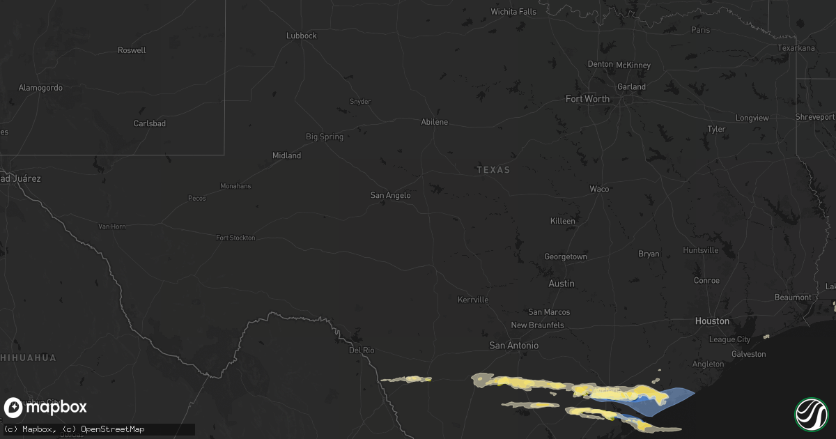
Hail Map in Texas on May 1, 2026
Get this storm
May 1 map
$229
one time, instant access
Download today. No call, no setup
Keep the $229
Bought the map and want the full workflow? Apply the entire $229 to a subscription within 7 days. None of it is wasted.
Every map, not just this one
This buys you this map. Subscription and you get every map we run, in the markets you choose from a few cities to whole states to nationwide. Plus real-time alerts the moment a storm fires.
Contact data
Name, contact info, occupancy, even credit band for addresses in the footprint. You go from where it hit to who to call.
Become the source they trust
Unlimited branding weather history reports on demand. You already have the documented answer ready for the property owner, and you are the one who showed up with it.
Property data and RoofTrace estimates
Pull up any address you have got, its value and the exact code rules for that jurisdiction, straight from One Click Code. Then RoofTrace estimates the squares, pitch, and roof value, priced the way you price.
Storm reports in Texas
Texas
| Date | Description |
|---|---|
| 05/01/20263:04 PM CDT | Tdem reported damage and images of overturned rvs. Time estimated by radar. |
| 05/01/20263:03 PM CDT | Asos station kpsx palacios measured a 77 mph wind gust. |
| 05/01/20263:03 PM CDT | Asos station kpsx palacios measured a 67 knot wind gust. |
| 05/01/20262:56 PM CDT | Asos station kpsx palacios measured a 60 mph wind gust. |
| 05/01/20262:31 PM CDT | Measured 1 inch hail at the high school. |
| 05/01/20262:19 PM CDT | Report of 3 train cars tipped partially over. Time and location approximated using radar. Corrected for time. |
| 05/01/20262:10 PM CDT | Kavu shared photos of a medium-sized tree snapped in half as well as large branches scattered on grand street right behind placedo elementary. |
| 05/01/20262:06 PM CDT | Report of 3 train cars tipped partially over. Time and location approximated using radar. |
| 05/01/20262:03 PM CDT | Photos of an outbuilding destroyed and other building damage nearby. |
| 05/01/20262:02 PM CDT | Nickel to quarter sized hail. Winds have knocked out power. |
| 05/01/20261:53 PM CDT | A local report indicates 1.00 inch wind near 7 ENE Fannin |
| 05/01/202612:52 PM CDT | Mixture of pea up to quarter size hail from western karnes city to kenedy. |
Cities Impacted by Hail Map on May 1, 2026
- Quemado, TX
- La Pryor, TX
- Batesville, TX
- Pearsall, TX
- Moore, TX
- Eagle Pass, TX
- Crystal City, TX
- Charlotte, TX
- Jourdanton, TX
- Bigfoot, TX
- Pleasanton, TX
- Poteet, TX
- Falls City, TX
- Campbellton, TX
- Tilden, TX
- Floresville, TX
- Hobson, TX
- Karnes City, TX
- Calliham, TX
- Port Bolivar, TX
- Kenedy, TX
- Runge, TX
- Whitsett, TX
- Three Rivers, TX
- Hackberry, LA
- Nordheim, TX
- Yorktown, TX
- Goliad, TX
- Lake Charles, LA
- Cameron, LA
- Beeville, TX
- Meyersville, TX
- Victoria, TX
- Refugio, TX
- Inez, TX
- Tivoli, TX
- Bloomington, TX
- Port Lavaca, TX
- Placedo, TX
- Edna, TX
- La Salle, TX
- Lolita, TX
- Vanderbilt, TX
- Seadrift, TX
- Palacios, TX
- Port O'Connor, TX
- Louise, TX
- Markham, TX
- Bay City, TX
- Midfield, TX
- El Campo, TX
- Blessing, TX
- Elmaton, TX
- Matagorda, TX


