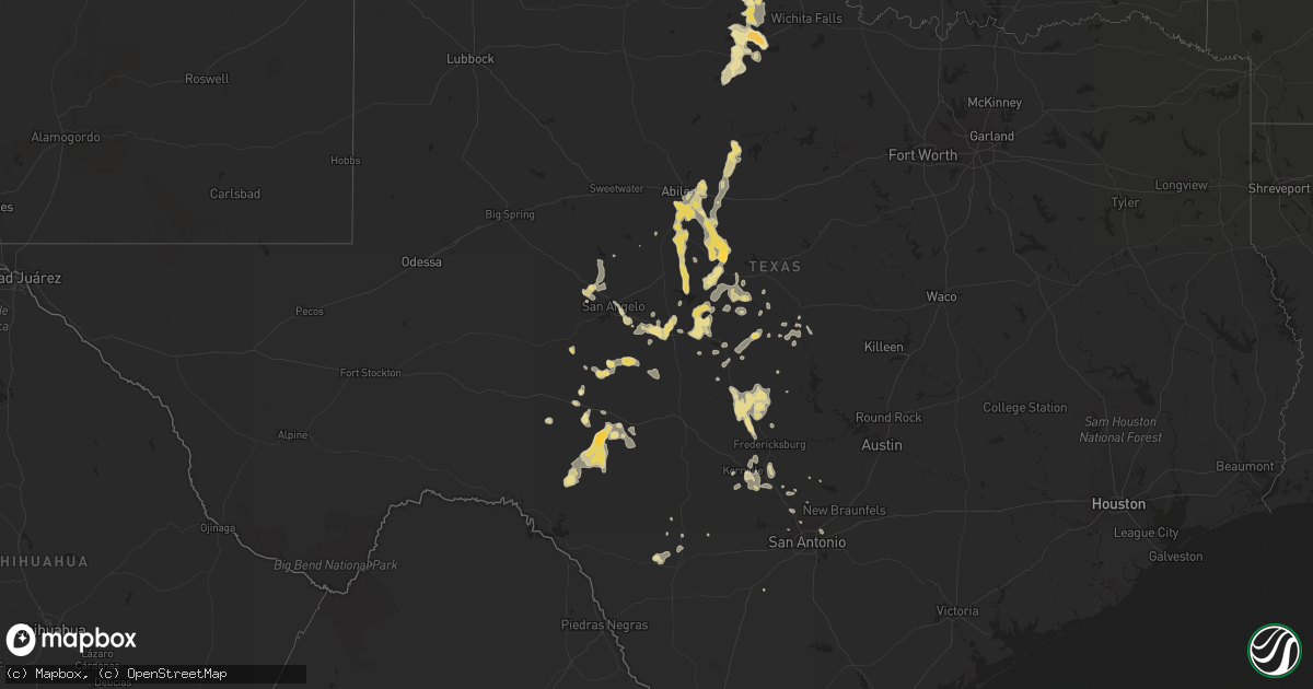
Hail Map in Texas on May 1, 2013
Get this storm
May 1 map
$229
one time, instant access
Download today. No call, no setup
Keep the $229
Bought the map and want the full workflow? Apply the entire $229 to a subscription within 7 days. None of it is wasted.
Every map, not just this one
This buys you this map. Subscription and you get every map we run, in the markets you choose from a few cities to whole states to nationwide. Plus real-time alerts the moment a storm fires.
Contact data
Name, contact info, occupancy, even credit band for addresses in the footprint. You go from where it hit to who to call.
Become the source they trust
Unlimited branding weather history reports on demand. You already have the documented answer ready for the property owner, and you are the one who showed up with it.
Property data and RoofTrace estimates
Pull up any address you have got, its value and the exact code rules for that jurisdiction, straight from One Click Code. Then RoofTrace estimates the squares, pitch, and roof value, priced the way you price.
Storm reports in Texas
Texas
| Date | Description |
|---|---|
| 05/01/20136:20 PM CDT | A local report indicates 1.00 inch wind near LAKE KEMP |
| 05/01/20136:00 PM CDT | Delayed report via nssl shave project. |
| 05/01/20131:05 AM CDT | Large tree branches down |
| 04/30/201311:55 PM CDT | Marble to quarter size hail |
| 04/30/20139:45 PM CDT | Golf ball size hail reported at the intersection of highway 206 and fm 1176 |
| 04/30/20139:26 PM CDT | A local report indicates 1.00 inch wind near 2 ENE DUDLEY |
| 04/30/20139:00 PM CDT | A local report indicates 1.00 inch wind near TUSCOLA |
| 04/30/20138:52 PM CDT | A local report indicates 1.00 inch wind near 1 W CLYDE |
| 04/30/20138:45 PM CDT | A local report indicates 1.25 inch wind near BUFFALO GAP |
| 04/30/20138:40 PM CDT | Large factory lost roof. Multiple very large trees and power lines down. |
| 04/30/20138:37 PM CDT | A local report indicates 60 MPH wind near 3 N ALBANY |
| 04/30/20138:32 PM CDT | A local report indicates 1.00 inch wind near 2 E ABILENE |
| 04/30/20138:30 PM CDT | Golf ball hail |
| 04/30/20138:25 PM CDT | A local report indicates 1.00 inch wind near 4 SE GRAPE CREEK |
| 04/30/20138:23 PM CDT | Roof missing off of house. Power lines also reported down. |
| 04/30/20138:15 PM CDT | A local report indicates 1.00 inch wind near GRAPE CREEK |
| 04/30/20137:44 PM CDT | A local report indicates 1.00 inch wind near THROCKMORTON |
| 04/30/20137:00 PM CDT | A local report indicates 1.75 inch wind near 6 WSW DUNDEE |
Cities Impacted by Hail Map on May 1, 2013
- Theodore, AL
- Mobile, AL
- Electra, TX
- Uvalde, TX
- Rio Frio, TX
- Gouldbusk, TX
- Santa Anna, TX
- Coleman, TX
- Clyde, TX
- Indiahoma, OK
- Mountain Park, OK
- Roosevelt, OK
- Saucier, MS
- San Antonio, TX
- Converse, TX
- San Angelo, TX
- Del Rio, TX
- Abilene, TX
- Christoval, TX
- Lohn, TX
- Doole, TX
- Melvin, TX
- Sonora, TX
- Burkett, TX
- Menard, TX
- San Saba, TX
- Bangs, TX
- Brownwood, TX
- Spivey, KS
- Brady, TX
- Chester, OK
- Comfort, TX
- Robert Lee, TX
- Carlsbad, TX
- Rockwood, TX
- Rochelle, TX
- Llano, TX
- Fredericksburg, TX
- Mason, TX
- Art, TX
- Doss, TX
- Castell, TX
- Newellton, LA
- Eldorado, TX
- Richland Springs, TX
- Lorman, MS
- Kerrville, TX
- Tuscola, TX
- Winters, TX
- Moran, KS
- Elsmore, KS
- Mooreland, OK
- Albany, TX
- Moran, TX
- Baird, TX
- Frederick, OK
- Seymour, TX
- Rocksprings, TX
- Goldthwaite, TX
- Harrold, TX
- Oklaunion, TX
- Ozona, TX
- Brookesmith, TX
- Center Point, TX
- Biloxi, MS
- Vancleave, MS
- Bronson, KS
- Eden, TX
- Ballinger, TX
- Novice, TX
- Voss, TX
- Ovalo, TX
- Goldsboro, TX
- Lawn, TX
- Talpa, TX
- Davidson, OK
- Medina, TX
- Hollister, OK
- Cross Plains, TX
- Gautier, MS
- Valley Spring, TX
- Fairhope, AL
- Daphne, AL
- Paint Rock, TX
- Millersview, TX
- Vancourt, TX
- Holliday, TX
- Burbank, OK
- Pawhuska, OK
- Shidler, OK
- Lometa, TX
- Spring Branch, TX
- Fairfax, OK
- Sabinal, TX
- Boerne, TX
- Miami, FL
- Hobart, OK
- Moss Point, MS
- Voca, TX
- Tescott, KS
- Grand Bay, AL
- Irvington, AL
- Pascagoula, MS
- Coden, AL
- Ocean Springs, MS
- Harper, KS
- Clifton, KS
- Eunice, LA
- Mertzon, TX
- Mullin, TX
- Bulverde, TX
- Moore, TX
- Kendalia, TX
- Eola, TX
- Altoona, KS
- Neodesha, KS


