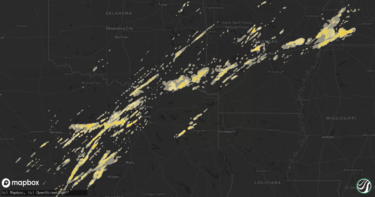
Hail Map in Arkansas on May 1, 2011
Get this storm
May 1 map
$229
one time, instant access
Download today. No call, no setup
Keep the $229
Bought the map and want the full workflow? Apply the entire $229 to a subscription within 7 days. None of it is wasted.
Every map, not just this one
This buys you this map. Subscription and you get every map we run, in the markets you choose from a few cities to whole states to nationwide. Plus real-time alerts the moment a storm fires.
Contact data
Name, contact info, occupancy, even credit band for addresses in the footprint. You go from where it hit to who to call.
Become the source they trust
Unlimited branding weather history reports on demand. You already have the documented answer ready for the property owner, and you are the one who showed up with it.
Property data and RoofTrace estimates
Pull up any address you have got, its value and the exact code rules for that jurisdiction, straight from One Click Code. Then RoofTrace estimates the squares, pitch, and roof value, priced the way you price.
Storm reports in Arkansas
Arkansas
| Date | Description |
|---|---|
| 05/01/20116:41 PM CDT | A local report indicates 1.00 inch wind near NEW HOPE |
| 05/01/20116:41 PM CDT | A local report indicates 1.00 inch wind near NORFORK |
| 05/01/20116:41 PM CDT | Hail fell for about 5 minutes. |
| 05/01/20116:40 PM CDT | Multiple trees and powerlines are down on the 6000 block of hwy 9. Some structural damage has been reported with one barn partially destoryed. |
| 05/01/20116:32 PM CDT | Hail was falling along hwy 95. |
| 05/01/20116:25 PM CDT | A local report indicates 1.00 inch wind near DIERKS |
| 05/01/20116:10 PM CDT | A local report indicates 1.00 inch wind near DIERKS |
| 05/01/20113:34 PM CDT | Pea sized hail to quarter sized hail was falling. |
| 05/01/20113:30 PM CDT | Dime to quarter sized hail fell in levy. |
| 05/01/20113:23 PM CDT | Quarter size hail fell at intersection of i-430 and col. Glenn road. |
| 05/01/20112:24 PM CDT | A local report indicates 1.75 inch wind near 2 SW WYE |
| 05/01/20112:22 PM CDT | Multiple trees down...homes damaged and power lines down at hwy 75 and 306 |
| 05/01/20111:35 PM CDT | A local report indicates 1.00 inch wind near HOWELL |
| 05/01/20111:17 PM CDT | Multiple trees are down on sand hill road and hwy 323. |
| 05/01/20111:17 PM CDT | A local report indicates 1.00 inch wind near BENTON |
| 05/01/20111:10 PM CDT | A local report indicates 1.00 inch wind near BRYANT |
| 05/01/201111:30 AM CDT | Quarter sized hail fell at the sheriffs office and in murfreesboro. |
| 04/30/20117:20 PM CDT | A local report indicates 1.00 inch wind near 2 E DIERKS |
| 04/30/20117:17 PM CDT | Couple of trees down along hwy 95. The trees were not blocking any roads. |
| 04/30/20117:13 PM CDT | A local report indicates 1.00 inch wind near OPAL |
| 04/30/20117:12 PM CDT | Quarter size hail falling a couple of miles south of dierks. |
Cities Impacted by Hail Map on May 1, 2011
- Brownwood, TX
- May, TX
- Wagoner, OK
- San Saba, TX
- Tow, TX
- Lampasas, TX
- Denton, TX
- Pilot Point, TX
- Aubrey, TX
- Memphis, TN
- Casa, AR
- Ola, AR
- Dardanelle, AR
- Mccurtain, OK
- Eastland, TX
- Brighton, TN
- Millington, TN
- Somerville, TN
- Stanton, TN
- Arlington, TN
- Atoka, TN
- Mason, TN
- Carrollton, TX
- The Colony, TX
- Cisco, TX
- Geronimo, OK
- Lawton, OK
- Hattieville, AR
- Cleveland, AR
- Atkins, AR
- Jerusalem, AR
- Atoka, OK
- Lane, OK
- Hot Springs National Park, AR
- Scotland, AR
- Russellville, AR
- Whitt, TX
- Perrin, TX
- Kingston, OK
- Madill, OK
- Lebanon, OK
- Burkett, TX
- Azle, TX
- Whitewright, TX
- Van Alstyne, TX
- Houston, AR
- Perryville, AR
- Graford, TX
- Canadian, OK
- Eufaula, OK
- Ozark, AR
- Ratcliff, AR
- Branch, AR
- Pontotoc, TX
- Cross Plains, TX
- San Angelo, TX
- Ranger, TX
- Breckenridge, TX
- Stephenville, TX
- Early, TX
- Zephyr, TX
- Comanche, TX
- Blanket, TX
- Brady, TX
- Richland Springs, TX
- Rochelle, TX
- Grand Prairie, TX
- Dallas, TX
- Irving, TX
- Dublin, TX
- Powderly, TX
- Fort Towson, OK
- Blossom, TX
- Detroit, TX
- Bagwell, TX
- Arthur City, TX
- Paris, TX
- Valliant, OK
- Gainesville, TX
- Thackerville, OK
- Dierks, AR
- Nashville, AR
- Gordon, TX
- Mingus, TX
- Evant, TX
- Hamilton, TX
- Joshua, TX
- Burleson, TX
- Benton, AR
- Lonsdale, AR
- Sawyer, OK
- Hugo, OK
- Coleman, OK
- Moran, TX
- Marietta, OK
- Poteau, OK
- Eagletown, OK
- Idabel, OK
- Watson, OK
- Garvin, OK
- Broken Bow, OK
- Gilmer, TX
- Allen, OK
- Ada, OK
- Aledo, TX
- Fort Worth, TX
- Cotton Plant, AR
- Griffithville, AR
- Augusta, AR
- Colt, AR
- McCrory, AR
- Palestine, AR
- Des Arc, AR
- Hunter, AR
- Mena, AR
- Kenefic, OK
- Milburn, OK
- Durant, OK
- Boswell, OK
- Princeton, TX
- Wylie, TX
- Cherokee, TX
- Itasca, TX
- Tyler, TX
- Delight, AR
- Belleville, AR
- Gatesville, TX
- Mineral Wells, TX
- Weatherford, TX
- Springtown, TX
- Tuscola, TX
- Blackwell, TX
- Wingate, TX
- Bronte, TX
- Mullin, TX
- Plumerville, AR
- Center Ridge, AR
- Springfield, AR
- Morrilton, AR
- Mason, TX
- Grandview, TX
- Daisy, OK
- Pittsburg, OK
- Red Oak, OK
- Talihina, OK
- Wilburton, OK
- Tuskahoma, OK
- Clayton, OK
- Lancaster, TX
- Winona, TX
- Celina, TX
- Crowley, TX
- Godley, TX
- Rising Star, TX
- Naval Air Station Jrb, TX
- Junction, TX
- Sidney, AR
- Hico, TX
- Halls, TN
- Midlothian, TX
- Venus, TX
- Drummonds, TN
- Munford, TN
- Coleman, TX
- Santa Anna, TX
- Lockesburg, AR
- Randlett, OK
- Temple, OK
- Walters, OK
- Plano, TX
- Richardson, TX
- Locust Grove, OK
- Grant, OK
- Santo, TX
- Palo Pinto, TX
- Strawn, TX
- Roland, OK
- Spiro, OK
- Bokoshe, OK
- Muldrow, OK
- England, AR
- Savoy, TX
- Dyersburg, TN
- Gladewater, TX
- Solgohachia, AR
- Mount Vernon, AR
- Duncanville, TX
- Desoto, TX
- Turrell, AR
- Gilmore, AR
- Coppell, TX
- Lewisville, TX
- Colleyville, TX
- Grapevine, TX
- Bonham, TX
- Trenton, TX
- Antlers, OK
- Rockwood, TX
- Little Rock, AR
- Justin, TX
- Haltom City, TX
- Newark, TX
- Little Elm, TX
- Bluff Dale, TX
- Haslet, TX
- Ponder, TX
- Boyd, TX
- Rhome, TX
- De Leon, TX
- Millsap, TX
- Prosper, TX
- Lipan, TX
- Argyle, TX
- Cleburne, TX
- Granbury, TX
- Earle, AR
- Tyronza, AR
- Lometa, TX
- Mertzon, TX
- Okolona, AR
- Sidney, TX
- Rufe, OK
- Rattan, OK
- Decatur, TX
- Sumner, TX
- Chandler, TX
- Arlington, TX
- Clinton, AR
- Dover, AR
- Hector, AR
- Whitesboro, TX
- Sterling City, TX
- Carlisle, AR
- Ozan, AR
- Bokchito, OK
- Linden, TX
- Hughes Springs, TX
- Abilene, TX
- Caddo, OK
- Calera, OK
- London, TX
- Bismarck, AR
- Arkadelphia, AR
- Mckinney, TX
- Allen, TX
- Osceola, AR
- Lonoke, AR
- Scott, AR
- Murfreesboro, AR
- Collinsville, TX
- Colbert, OK
- Tioga, TX
- Cartwright, OK
- Howe, TX
- Mead, OK
- Sadler, TX
- Denison, TX
- Valley View, TX
- Sherman, TX
- Pottsboro, TX
- Gordonville, TX
- Henning, TN
- Van Buren, AR
- Rudy, AR
- Alma, AR
- Voca, TX
- Gustine, TX
- Rio Vista, TX
- Caney, OK
- Anna, TX
- Tishomingo, OK
- Forney, TX
- Ector, TX
- Purmela, TX
- Jonesboro, TX
- Cranfills Gap, TX
- Clifton, TX
- Llano, TX
- Valley Mills, TX
- Meridian, TX
- Fredonia, TX
- Star, TX
- Bluffton, TX
- Iredell, TX
- Copperas Cove, TX
- Goldthwaite, TX
- Roland, AR
- Bigelow, AR
- Rose, OK
- Salina, OK
- Caraway, AR
- Roff, OK
- Brinkley, AR
- Moro, AR
- Brookston, TX
- Big Sandy, TX
- Ivanhoe, TX
- Widener, AR
- North Little Rock, AR
- Paron, AR
- Maumelle, AR
- Conway, AR
- Mayflower, AR
- Mansfield, TX
- Kennedale, TX
- Rush Springs, OK
- Glenwood, AR
- Bonnerdale, AR
- Caddo Gap, AR
- Avinger, TX
- Daingerfield, TX
- Pittsburg, TX
- Ore City, TX
- Lone Star, TX
- Newcastle, TX
- Graham, TX
- Alvarado, TX
- Seagoville, TX
- Mesquite, TX
- Wabbaseka, AR
- Humnoke, AR
- Ridgely, TN
- Merkel, TX
- Sunnyvale, TX
- Balch Springs, TX
- Blytheville, AR
- Finley, TN
- Lake City, AR
- Alvord, TX
- Anson, TX
- Langley, AR
- Newhope, AR
- Kirby, AR
- Hughes, AR
- West Memphis, AR
- Eads, TN
- Luxora, AR
- Marion, AR
- Wilson, AR
- Ripley, TN
- Parkin, AR
- Covington, TN
- Crawfordsville, AR
- Proctor, AR
- Bassett, AR
- Joiner, AR
- Heth, AR
- Dyess, AR
- Edmondson, AR
- Frenchmans Bayou, AR
- Oakland, TN
- Addison, TX
- Gouldbusk, TX
- Stuttgart, AR
- Wright City, OK
- Gillham, AR
- Wickes, AR
- Cove, AR
- Grannis, AR
- Wewoka, OK
- Smithville, OK
- Morgan, TX
- Kopperl, TX
- Clyde, TX
- Ovalo, TX
- Stringtown, OK
- Danville, AR
- Pottsville, AR
- Hurst, TX
- Baird, TX
- Hartshorne, OK
- Blanco, OK
- Keo, AR
- Heavener, OK
- Menard, TX
- Lepanto, AR
- Cordova, TN
- Whiteville, TN
- Marianna, AR
- Forrest City, AR
- Keiser, AR
- Royal, AR
- Amity, AR
- Horatio, AR
- Mount Ida, AR
- Norman, AR
- Umpire, AR
- Mill Creek, OK
- Desdemona, TX
- Norfork, AR
- Mountain Home, AR
- Flippin, AR
- Glen Rose, TX
- Marietta, TX
- Woodson, TX
- Hartford, AR
- Stonewall, OK
- Blum, TX
- Holliday, TX
- De Valls Bluff, AR
- Mabelvale, AR
- Traskwood, AR
- Alexander, AR
- Bauxite, AR
- Bryant, AR
- Dodd City, TX
- Windom, TX
- Hazen, AR
- Vilonia, AR
- Evening Shade, AR
- Horseshoe Bend, AR
- Maryneal, TX
- Sunset, TX
- Ardmore, OK
- Mannsville, OK
- Caddo, TX
- Jessieville, AR
- Clarksville, TX
- Millersview, TX
- Gorman, TX
- Carbon, TX
- Euless, TX
- Romance, AR
- Paint Rock, TX
- Nemo, TX
- Hodgen, OK
- Stilwell, OK
- Waxahachie, TX
- Red Oak, TX
- Cedar Hill, TX
- Peggs, OK
- Hawley, TX
- Frisco, TX
- Honey Grove, TX
- Searcy, AR
- Pangburn, AR
- Letona, AR
- Tolar, TX
- Stigler, OK
- Wynne, AR
- Muenster, TX
- Robert Lee, TX
- Carlton, TX
- Kiowa, OK
- Porter, OK
- Covington, TX
- De Queen, AR
- Rosston, TX
- Yellville, AR
- Sachse, TX
- Hatfield, AR
- Keota, OK
- Newbern, TN
- Friendship, TN
- Sanger, TX
- Winthrop, AR
- Collierville, TN
- Hot Springs Village, AR
- Priddy, TX
- North Richland Hills, TX
- Prim, AR
- Edgemont, AR
- Mountainburg, AR
- Southlake, TX
- Albany, TX
- Poolville, TX
- Roanoke, TX
- Paradise, TX
- Lake Dallas, TX
- Cresson, TX
- Gunter, TX
- Keller, TX
- Krum, TX
- Ben Wheeler, TX
- Burlison, TN
- Gates, TN
- Eden, TX
- Muse, OK
- Comanche, OK
- Calico Rock, AR
- Melvin, TX
- Hickory Plains, AR
- Ward, AR
- Brownsboro, TX
- Malvern, AR
- Donaldson, AR
- Eldorado, TX
- Shirley, AR
- Hext, TX
- Stamford, TX
- Mountain Pine, AR
- Era, TX
- Duncan, OK
- Haworth, OK
- Hillsboro, TX
- Chouteau, OK
- Old Glory, TX
- Rule, TX
- Aspermont, TX
- Telephone, TX
- Bennington, OK
- Mineral Springs, AR
- Sallisaw, OK
- Gans, OK
- Mount Pleasant, AR
- Plainview, AR
- Tahlequah, OK
- Proctor, OK
- Goldsboro, TX
- Winters, TX
- Novice, TX
- Trenton, TN
- Avery, TX
- Mountain View, AR
- Aquilla, TX
- Ferris, TX
- Wilmer, TX
- Ringold, OK
- Doole, TX
- Lohn, TX
- Lindsay, TX
- Sherwood, AR
- Paris, AR
- Coal Hill, AR
- Altus, AR
- Flower Mound, TX
- Fairfield Bay, AR


