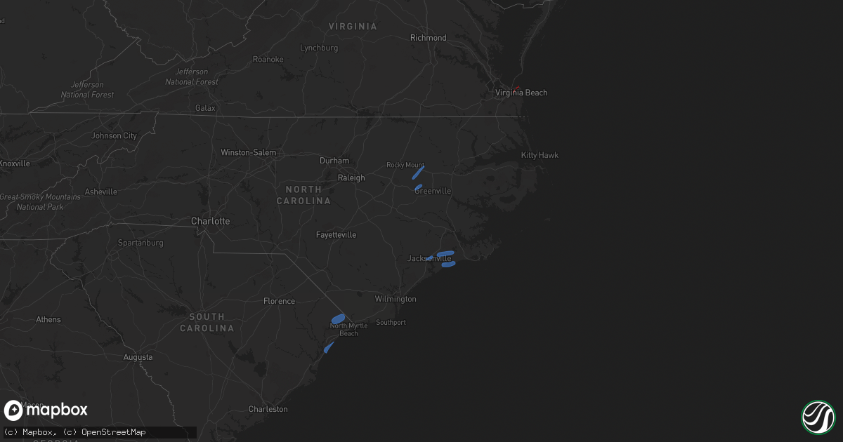
Hail Map in North Carolina on April 30, 2023
Get this storm
April 30 map
$229
one time, instant access
Download today. No call, no setup
Keep the $229
Bought the map and want the full workflow? Apply the entire $229 to a subscription within 7 days. None of it is wasted.
Every map, not just this one
This buys you this map. Subscription and you get every map we run, in the markets you choose from a few cities to whole states to nationwide. Plus real-time alerts the moment a storm fires.
Contact data
Name, contact info, occupancy, even credit band for addresses in the footprint. You go from where it hit to who to call.
Become the source they trust
Unlimited branding weather history reports on demand. You already have the documented answer ready for the property owner, and you are the one who showed up with it.
Property data and RoofTrace estimates
Pull up any address you have got, its value and the exact code rules for that jurisdiction, straight from One Click Code. Then RoofTrace estimates the squares, pitch, and roof value, priced the way you price.
Storm reports in North Carolina
North Carolina
| Date | Description |
|---|---|
| 04/30/20233:44 PM CDT | Report from mping: 1-inch tree limbs broken; shingles blown off. |
| 04/30/20233:30 PM CDT | Trained spotter reports multiple large tree limbs down. |
| 04/30/20233:19 PM CDT | Nws employee sent in picture to report large tree down in front of a home. Also reported evidence of tree down across hwy70 but the tree has already been cleared... Deb |
| 04/30/20233:15 PM CDT | Tree down on murphy road in brices creek. |
| 04/30/20233:15 PM CDT | Tree downed along wise store rd. Power is out in the area. |
| 04/30/20233:14 PM CDT | Report from mping: 3-inch tree limbs broken; power poles broken. Time adjusted based on radar. |
| 04/30/20232:46 PM CDT | Caller reported a measured wind gust of 60 mph in greenville. |
| 04/30/20232:45 PM CDT | Tree down on rhodestown road. |
| 04/30/20232:43 PM CDT | Large tree down in holly shelter gameland. |
| 04/30/20232:42 PM CDT | Report from mping: 1-inch tree limbs broken; shingles blown off. |
| 04/30/20232:35 PM CDT | Multiple trees reported down at caryle rd... Pilot community... Franklin county. |
| 04/30/20232:33 PM CDT | Widespread trees down across edgecombe county especially across tarboro... Nc. |
| 04/30/20232:22 PM CDT | Tree on car in macclesfield... Nc no injuries. |
| 04/30/20232:07 PM CDT | Numerous trees down along woodbridge rd. Time estimated based on radar. |
| 04/30/20232:07 PM CDT | Add information to tstm wnd dmg report from 2 wnw stantonsburg. Numerous trees down along woodbridge rd... One tree punctured roof of residence. No injuries reported. T |
| 04/30/20232:02 PM CDT | One tree downed and outbuilding destroyed. Time estimated by radar. |
| 04/30/20232:00 PM CDT | Tree down on power line caused a transformer fire. |
| 04/30/20231:59 PM CDT | Several trees and powerlines down along upper black creek church road south of harrell store road. |
| 04/30/20231:56 PM CDT | Tree down at dobbersville rd and raynor mill rd. |
| 04/30/20231:56 PM CDT | Numerous trees and power lines down near frank rd and kirby rd. Time estimated based on radar. |
| 04/30/20231:54 PM CDT | An outbuilding destroyed and damage to a residence... In addition to multiple trees down along frank road near nc-581. There were no injuries. |
| 04/30/20231:52 PM CDT | 1 tree along 500 block of dobbersville rd. |
| 04/30/20231:51 PM CDT | Tree down at john st and vine st. |
| 04/30/20231:51 PM CDT | Multiple trees down near nc-581 and pinkney church rd. |
| 04/30/20231:50 PM CDT | Several tress down on trails across blue jay point county park. Time estimated by radar. |
| 04/30/20231:43 PM CDT | 1 tree down at princeton rd and oakland church rd. |
| 04/30/20231:42 PM CDT | Multiple reports of trees down from selma to kenly. |
| 04/30/20231:27 PM CDT | Numerous reports of trees down... 14 in total... Spanning from autryville to near dunn to turkey and faison... Nc. |
| 04/30/202312:55 PM CDT | Roof partially peeled off house. |
| 04/30/202312:44 PM CDT | Numerous trees down along tabor church rd and cedar creek rd. Time estimated based on radar. |


