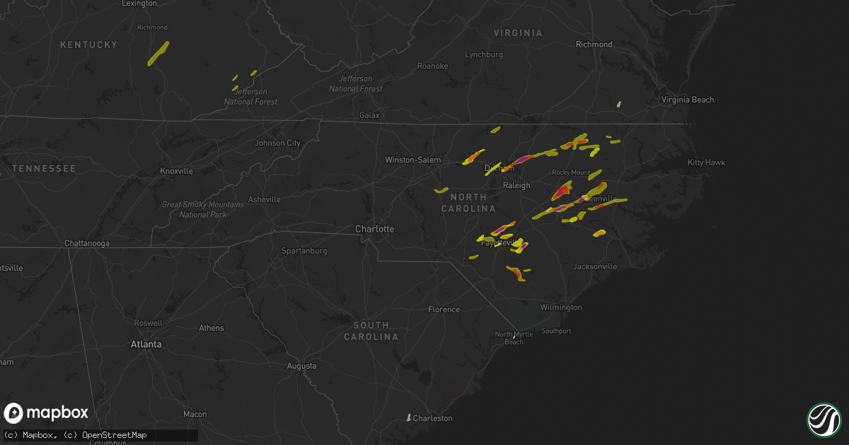
Hail Map in North Carolina on April 30, 2014
Get this storm
April 30 map
$229
one time, instant access
Download today. No call, no setup
Keep the $229
Bought the map and want the full workflow? Apply the entire $229 to a subscription within 7 days. None of it is wasted.
Every map, not just this one
This buys you this map. Subscription and you get every map we run, in the markets you choose from a few cities to whole states to nationwide. Plus real-time alerts the moment a storm fires.
Contact data
Name, contact info, occupancy, even credit band for addresses in the footprint. You go from where it hit to who to call.
Become the source they trust
Unlimited branding weather history reports on demand. You already have the documented answer ready for the property owner, and you are the one who showed up with it.
Property data and RoofTrace estimates
Pull up any address you have got, its value and the exact code rules for that jurisdiction, straight from One Click Code. Then RoofTrace estimates the squares, pitch, and roof value, priced the way you price.
Storm reports in North Carolina
North Carolina
| Date | Description |
|---|---|
| 04/30/20143:00 PM CDT | Estimated wind gust to 60 mph in greenville. Shook the house and knoecked down a tree limb. |
| 04/30/20142:40 PM CDT | Estimated wind gust to 60mph on gum branch road |
| 04/30/20142:40 PM CDT | Damage to skate park in jacksonville commons recreational center. Fence and several skate ramps were damaged. Time estimated by radar. |
| 04/30/20141:50 PM CDT | Numerous trees down between the faison and calypso area |
| 04/30/20141:30 PM CDT | Tree down on a car on the mainland side of ocean isle beach. Fire department has been dispatched |
All States Impacted by Hail Map on April 30, 2014
Cities Impacted by Hail Map on April 30, 2014
- Panama City, FL
- Weirsdale, FL
- Leesburg, FL
- Umatilla, FL
- Saint Johns, FL
- Green Cove Springs, FL
- Saint Augustine, FL
- Baker, FL
- Holt, FL
- Mims, FL
- Osteen, FL
- Moore Haven, FL
- Brooksville, FL
- Spring Hill, FL
- Sedley, VA
- Courtland, VA
- Orlando, FL
- Sebring, FL
- Port Saint Joe, FL
- Wewahitchka, FL
- Opp, AL
- Andalusia, AL
- Florala, AL
- Hawthorne, FL
- Interlachen, FL
- Immokalee, FL
- Samson, AL
- Kinston, AL
- Ocala, FL
- Haines City, FL
- Laurel Hill, FL
- Coffee Springs, AL
- Adams Run, SC
- Ravenel, SC
- Naples, FL
- New Brockton, AL
- Enterprise, AL
- Ponte Vedra Beach, FL
- Ponte Vedra, FL
- Savannah, GA
- Chancellor, AL
- Palm Coast, FL
- Bunnell, FL
- Flagler Beach, FL
- Ormond Beach, FL
- Clermont, FL
- Groveland, FL
- Saint Cloud, FL
- Deland, FL
- Orange City, FL
- Frostproof, FL
- Kenansville, FL
- Citra, FL
- Reddick, FL
- Lake Placid, FL
- Christmas, FL
- Fort McCoy, FL
- Anthony, FL
- Campbellton, FL
- Elba, AL
- Winter Garden, FL
- Little River, SC
- North Myrtle Beach, SC
- Remus, MI
- Lakeview, MI
- Blanchard, MI
- Cedar Springs, MI
- Sand Lake, MI
- Kent City, MI
- Sparta, MI
- Conklin, MI
- Clare, MI
- Weidman, MI
- Rosebush, MI
- Mount Pleasant, MI
- Coleman, MI
- Howard City, MI
- Pierson, MI
- Coral, MI
- Trufant, MI
- Newaygo, MI
- Morley, MI
- Fremont, MI
- Montague, MI
- Whitehall, MI
- Grant, MI
- Muskegon, MI
- Holton, MI
- Twin Lake, MI
- Six Lakes, MI
- Rockford, MI
- Orleans, MI
- Greenville, MI
- Gowen, MI
- Casnovia, MI
- Belding, MI
- Fenwick, MI
- West Olive, MI
- Cove City, NC
- Trenton, NC
- Dover, NC
- Stedman, NC
- Roseboro, NC
- Autryville, NC
- Salemburg, NC
- Wade, NC
- Fayetteville, NC
- Greenville, NC
- Farmville, NC
- Kenly, NC
- Lucama, NC
- Elm City, NC
- Wilson, NC
- La Grange, NC
- Princeton, NC
- Pikeville, NC
- Durham, NC
- Carrboro, NC
- Chapel Hill, NC
- Fort Bragg, NC
- Linden, NC
- Pope Army Airfield, NC
- Erwin, NC
- Spring Lake, NC
- Dunn, NC
- Haw River, NC
- Mebane, NC
- Cedar Grove, NC
- Efland, NC
- Burlington, NC
- Graham, NC
- Kinston, NC
- Snow Hill, NC
- Hookerton, NC
- Walstonburg, NC
- Stantonsburg, NC
- Bethel, NC
- Stokes, NC
- Fountain, NC
- Robersonville, NC
- Goldsboro, NC
- Roanoke Rapids, NC
- Littleton, NC
- Weldon, NC
- Halifax, NC
- Enfield, NC
- Hollister, NC
- Jackson, NC
- Aulander, NC
- Woodland, NC
- Ahoskie, NC
- Tarboro, NC
- Hobgood, NC
- Oak City, NC
- Ayden, NC
- Winterville, NC
- Washington, NC
- Grimesland, NC
- Roxboro, NC
- Warrenton, NC
- Kittrell, NC
- Castalia, NC
- Creedmoor, NC
- Whitakers, NC
- Wake Forest, NC
- Franklinton, NC
- Youngsville, NC
- Nashville, NC
- Louisburg, NC
- Asheboro, NC
- Franklinville, NC
- Rich Square, NC
- Four Oaks, NC
- Smithfield, NC
- Fremont, NC
- Conway, NC
- Wagram, NC
- Laurinburg, NC
- Maxton, NC
- Red Springs, NC
- Raeford, NC
- Scotland Neck, NC
- Clarkton, NC
- Elizabethtown, NC
- Tar Heel, NC
- White Oak, NC
- Garland, NC
- Harrells, NC
- Mount Vernon, KY
- Sandgap, KY
- Livingston, KY
- McKee, KY
- Orlando, KY
- Cornettsville, KY
- Hallie, KY
- Blackey, KY
- Gordon, KY
- Linefork, KY
- Cumberland, KY
- Mayking, KY
- Thornton, KY
- Neon, KY
- Seco, KY
- Jenkins, KY
- Millstone, KY
- McRoberts, KY
- Whitesburg, KY


