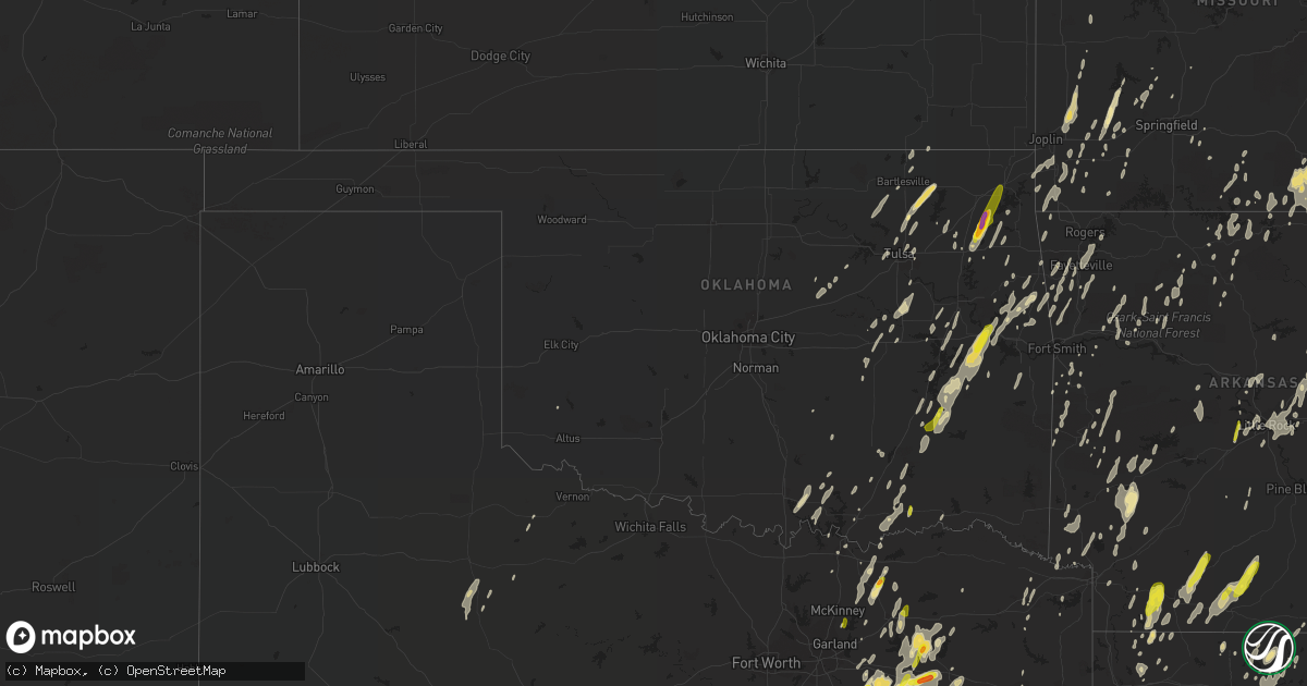
Hail Map in Oklahoma on April 29, 2017
Get this storm
April 29 map
$229
one time, instant access
Download today. No call, no setup
Keep the $229
Bought the map and want the full workflow? Apply the entire $229 to a subscription within 7 days. None of it is wasted.
Every map, not just this one
This buys you this map. Subscription and you get every map we run, in the markets you choose from a few cities to whole states to nationwide. Plus real-time alerts the moment a storm fires.
Contact data
Name, contact info, occupancy, even credit band for addresses in the footprint. You go from where it hit to who to call.
Become the source they trust
Unlimited branding weather history reports on demand. You already have the documented answer ready for the property owner, and you are the one who showed up with it.
Property data and RoofTrace estimates
Pull up any address you have got, its value and the exact code rules for that jurisdiction, straight from One Click Code. Then RoofTrace estimates the squares, pitch, and roof value, priced the way you price.
Storm reports in Oklahoma
Oklahoma
| Date | Description |
|---|---|
| 04/29/20176:25 PM CDT | Relayed via social media and associated picture. |
| 04/29/20176:15 PM CDT | Near the intersection of 440 west and 435 north |
| 04/29/20176:15 PM CDT | Several trees down |
| 04/29/20175:59 PM CDT | A local report indicates 60 MPH wind near QUINTON |
| 04/29/20175:30 PM CDT | Time estimated via radar. |
| 04/29/20174:18 PM CDT | A tornado began causing damage at the southeast edge of sallisaw and it continued northeast. The survey team was unable to complete the assessment. The team will return |
| 04/29/20174:15 PM CDT | Several trees down in and around sallisaw. Time estimated by radar. |
| 04/29/20174:10 PM CDT | A local report indicates 1.00 inch wind near HARTSHORNE |
| 04/29/20174:00 PM CDT | Pea to quarter size hail in boswell |
| 04/28/20179:03 PM CDT | Numerous large tree limbs down. A private weather station measured a 66 mph wind gust just northwest of eagletown. |
| 04/28/20177:45 PM CDT | A local report indicates 1.25 inch wind near 10 E OVERBROOK |
| 04/28/20177:14 PM CDT | Large tree down |
| 04/28/20177:03 PM CDT | Numerous trees down. |
All States Impacted by Hail Map on April 29, 2017
Cities Impacted by Hail Map on April 29, 2017
- Lamar, MO
- San Antonio, TX
- Elmendorf, TX
- Stanton, KY
- Brighton, IL
- Dorsey, IL
- Bunker Hill, IL
- Alton, IL
- Scurry, TX
- Kaufman, TX
- Morrow, AR
- Canehill, AR
- Mabank, TX
- Trinidad, TX
- Greenville, TX
- Lone Oak, TX
- Campbell, TX
- Pleasanton, TX
- Floresville, TX
- Pryor, OK
- Greenfield, OH
- Texarkana, AR
- Point, TX
- Emory, TX
- Sugar Grove, OH
- Rockbridge, OH
- Logan, OH
- Minden, LA
- Emerson, AR
- El Dorado, AR
- Mount Holly, AR
- Magnolia, AR
- Toccoa, GA
- Westminster, SC
- Walhalla, SC
- Stephens, AR
- Camden, AR
- Glade Spring, VA
- Meadowview, VA
- Chilhowie, VA
- Damascus, VA
- Quitman, LA
- Ruston, LA
- Choudrant, LA
- Jonesville, LA
- Marksville, LA
- Smackover, AR
- McKee, KY
- Bedford, KY
- Kemp, TX
- Norman, AR
- Glenwood, AR
- Caddo Gap, AR
- Langley, AR
- Kinder, LA
- Oberlin, LA
- Golden City, MO
- Carthage, MO
- Jasper, MO
- Bethany, IL
- Dalton City, IL
- Mena, AR
- Hampton, AR
- Louann, AR
- Searcy, AR
- Irvine, KY
- Ravenna, KY
- Refugio, TX
- Woodsboro, TX
- Cotton Valley, LA
- Palmer, IL
- Taylorville, IL
- Morrisonville, IL
- Bradford, AR
- Tahlequah, OK
- Welling, OK
- Fred, TX
- Kountze, TX
- Spurger, TX
- Woodville, TX
- Hillister, TX
- Warren, TX
- Oktaha, OK
- Boynton, OK
- Hartshorne, OK
- Wilburton, OK
- Poplar Bluff, MO
- Grandin, MO
- Ellsinore, MO
- Williamsville, MO
- Hemphill, TX
- Starks, LA
- Bon Wier, TX
- Anacoco, LA
- Vidor, TX
- Deweyville, TX
- Newton, TX
- Wiergate, TX
- Kirbyville, TX
- Burkeville, TX
- Orange, TX
- Call, TX
- Merryville, LA
- Florien, LA
- Many, LA
- Buna, TX
- Ardmore, OK
- Marietta, OK
- Madill, OK
- Madison, IN
- Canaan, IN
- Charleston, AR
- Thompsonville, IL
- Dahlgren, IL
- Benton, IL
- Ewing, IL
- Wayne City, IL
- McLeansboro, IL
- Macedonia, IL
- Robeline, LA
- Sledge, MS
- Leachville, AR
- Dalton, GA
- Silsbee, TX
- Lumberton, TX
- Graysville, TN
- Dunlap, TN
- Soddy Daisy, TN
- Parsons, KS
- Ashdown, AR
- Taylor, AR
- Waldo, AR
- Stamps, AR
- Buckner, AR
- Talala, OK
- Nowata, OK
- South Greenfield, MO
- Miller, MO
- North Little Rock, AR
- Springdale, AR
- Red Oak, OK
- Kinta, OK
- Jasper, TX
- Lake Charles, LA
- Dennis, KS
- Cherryvale, KS
- Mound Valley, KS
- McRae, AR
- Vevay, IN
- Carrollton, KY
- Collinsville, OK
- Ramona, OK
- Whitwell, TN
- Palmer, TN
- Beaumont, TX
- Uniontown, AR
- Natural Dam, AR
- Natchitoches, LA
- Saltville, VA
- Bolivar, MO
- Dexter, KS
- Forrest City, AR
- Hindman, KY
- Mallie, KY
- Pine Top, KY
- Vian, OK
- Marshall, AR
- Checotah, OK
- Eufaula, OK
- Mount Vernon, MO
- Freistatt, MO
- Monett, MO
- Plain Dealing, LA
- Combs, AR
- Bell City, LA
- Three Rivers, TX
- Campbellton, TX
- Whitsett, TX
- Sugar Grove, VA
- Marion, VA
- West Monroe, LA
- Eros, LA
- Columbia, LA
- Grayson, LA
- Bloomfield, KY
- Springfield, KY
- Willisburg, KY
- Jennings, LA
- Iota, LA
- Lake Arthur, LA
- Basile, LA
- De Soto, IL
- Murphysboro, IL
- Goreville, IL
- Buncombe, IL
- Marion, IL
- Oceana, WV
- Wharton, WV
- Pineland, TX
- Waldron, AR
- Parks, AR
- Greenfield, MO
- Longview, TX
- Udall, MO
- Gainesville, MO
- Tecumseh, MO
- Bakersfield, MO
- Dora, MO
- Caulfield, MO
- Coahoma, MS
- Dundee, MS
- Provencal, LA
- Cedar Vale, KS
- Cambridge, KS
- Des Arc, MO
- Annapolis, MO
- Patterson, MO
- Wilmot, AR
- Sarepta, LA
- Springhill, LA
- Bonham, TX
- Leonard, TX
- Wolfe City, TX
- Bailey, TX
- Celeste, TX
- Quinton, OK
- Piedmont, MO
- Leesville, LA
- Van Buren, AR
- West Fork, AR
- Cedarville, AR
- Chester, AR
- Rudy, AR
- Crowell, TX
- Naoma, WV
- Cyclone, WV
- Abingdon, VA
- Fulton, AR
- Washington, AR
- Eustace, TX
- Kerens, TX
- Malakoff, TX
- Athens, TX
- Ward, AR
- Beebe, AR
- Harrison, AR
- Stoutsville, OH
- Circleville, OH
- Coal Hill, AR
- Altus, AR
- Midway, AR
- Gassville, AR
- Mountain Home, AR
- Gillespie, IL
- Carlinville, IL
- Ellington, MO
- Bennington, OK
- Metcalf, IL
- Catlin, IL
- Ridge Farm, IL
- Georgetown, IL
- Indianola, IL
- Chrisman, IL
- Hugo, OK
- Grant, OK
- Victoria, TX
- Lockesburg, AR
- Horatio, AR
- Adair, OK
- Vinita, OK
- Strang, OK
- Livingston, TN
- Cookeville, TN
- Gainesboro, TN
- Hilham, TN
- Mosheim, TN
- Greeneville, TN
- Wood River, IL
- Morse, LA
- O'Fallon, IL
- Lebanon, IL
- Lindale, TX
- Welsh, LA
- Elton, LA
- Fayetteville, AR
- Lincoln, AR
- Harvel, IL
- Chidester, AR
- Pawnee, IL
- Kincaid, IL
- Berwind, WV
- Bald Knob, AR
- Saint Louis, MO
- Carbondale, IL
- Tyler, TX
- Limestone, TN
- Chuckey, TN
- Salina, OK
- Rose, OK
- Bokchito, OK
- Mineola, TX
- Murfreesboro, AR
- Delight, AR
- Nashville, AR
- Baytown, TX
- Martinsville, OH
- Midland, OH
- Sparta, TN
- Ozark, AR
- Mulberry, AR
- Sedgewickville, MO
- Perryville, MO
- Downsville, LA
- Yantis, TX
- Guerra, TX
- Zapata, TX
- Hebbronville, TX
- Sparta, IL
- Chester, IL
- Steeleville, IL
- Edwardsville, IL
- Canton, TX
- Grand Saline, TX
- Cushing, OK
- Sarcoxie, MO
- Butler, IL
- Raymond, IL
- Tannersville, VA
- Broadford, VA
- Hagarville, AR
- Canadian, OK
- Mcalester, OK
- Crowder, OK
- Utopia, TX
- Grand Tower, IL
- Wolf Lake, IL
- Jackson, MO
- Gueydan, LA
- Lyon, MS
- Clarksdale, MS
- Dayton, TX
- Edgewood, TX
- Wills Point, TX
- Tulsa, OK
- Arcadia, MO
- Ragley, LA
- Peace Valley, MO
- Pomona, MO
- West Plains, MO
- Pottersville, MO
- Pendleton, KY
- Turners Station, KY
- Ghent, KY
- Campbellsburg, KY
- Milton, KY
- Sanders, KY
- Westport, KY
- Worthville, KY
- Delaplaine, AR
- Beech Grove, AR
- Walnut Ridge, AR
- Broaddus, TX
- Colmesneil, TX
- Zavalla, TX
- Reeves, LA
- Mittie, LA
- Milam, TX
- Bronson, TX
- Spavinaw, OK
- Bradley, AR
- Opelousas, LA
- Roland, AR
- Sunman, IN
- West Alton, MO
- Liberty, KS
- Goldonna, LA
- Saline, LA
- Jonesboro, LA
- Commerce, TX
- Blanchester, OH
- Fayetteville, OH
- Pleasant Plain, OH
- Goshen, OH
- Farmerville, LA
- Marion, LA
- Seymour, TX
- Knox City, TX
- Locust Grove, OK
- Big Cabin, OK
- Chouteau, OK
- Greenville, IL
- Donnellson, IL
- Stewardson, IL
- Shumway, IL
- Cameron, LA
- Ava, MO
- Neosho, MO
- Goodman, MO
- Natchez, MS
- Wilmington, OH
- New Vienna, OH
- Colfax, LA
- Eunice, LA
- Anna, TX
- Blue Ridge, TX
- Trenton, TX
- Whitewright, TX
- Ulm, AR
- Carlisle, AR
- Hazen, AR
- Humnoke, AR
- Stuttgart, AR
- Banner, KY
- Printer, KY
- Martin, KY
- Dana, KY
- Wytheville, VA
- Judsonia, AR
- Loretto, KY
- Harrison, OH
- Miamitown, OH
- Cincinnati, OH
- Cleves, OH
- Shongaloo, LA
- Amagon, AR
- Weiner, AR
- Rural Retreat, VA
- Crockett, VA
- Atkins, VA
- Hume, IL
- Westville, IL
- Perrysville, IN
- Cayuga, IN
- Sidell, IL
- Danville, IL
- Brocton, IL
- Beeville, TX
- Tishomingo, OK
- Brookeland, TX
- Casey, IL
- Marianna, AR
- Pikeville, TN
- Alton, MO
- Birch Tree, MO
- Fremont, MO
- Winona, MO
- Mountain Rest, SC
- Eastanollee, GA
- Falls City, TX
- Afton, TN
- Deer, AR
- Jasper, AR
- Brandsville, MO
- Gepp, AR
- Thayer, MO
- Mammoth Spring, AR
- Willow Springs, MO
- Salem, AR
- Moody, MO
- Sturkie, AR
- Koshkonong, MO
- Viola, AR
- Medina, TX
- Saint Joseph, LA
- Clayton, LA
- Leesburg, OH
- Fisher, LA
- Gentry, AR
- Decatur, AR
- Walnut Grove, MO
- Vera, OK
- Grand Chenier, LA
- Creole, LA
- Shady Point, OK
- Bokoshe, OK
- Milburn, OK
- Coleman, OK
- Clarkesville, GA
- Long Creek, SC
- Alexander, AR
- Little Rock, AR
- Benton, AR
- Seneca, MO
- Wyandotte, OK
- Cash, AR
- Saint Francis, KY
- New Hope, KY
- Raywick, KY
- Greenwood, AR
- Gravette, AR
- Sulphur Springs, AR
- Keenes, IL
- Johnsonville, IL
- Macon, IL
- Farmersville, TX
- Nevada, TX
- Smithboro, IL
- Keyesport, IL
- Shobonier, IL
- Vandalia, IL
- Mulberry Grove, IL
- Brownstown, IL
- Pesotum, IL
- Villa Grove, IL
- Tolono, IL
- Tuscola, IL
- Lacassine, LA
- De Kalb, TX
- Florence, TX
- Jarrell, TX
- Granby, MO
- Stella, MO
- Stark City, MO
- Winslow, AR
- Coushatta, LA
- Florissant, MO
- Hazelwood, MO
- Bridgeton, MO
- Ft Mitchell, KY
- Independence, KY
- Latonia, KY
- Roanoke, LA
- Stockdale, TX
- Bastrop, LA
- Williamsburg, OH
- Chatham, LA
- Eucha, OK
- Hebron, KY
- Petersburg, KY
- Burlington, KY
- Egan, LA
- New Douglas, IL
- Sorento, IL
- Nokomis, IL
- Leslie, AR
- Oakland, AR
- Flippin, AR
- Yellville, AR
- Bull Shoals, AR
- Lakeview, AR
- Arcola, IL
- Pencil Bluff, AR
- Oden, AR
- Oakdale, LA
- Gravel Switch, KY
- Stanford, KY
- Lancaster, KY
- Danville, KY
- Nicholasville, KY
- Junction City, KY
- Hustonville, KY
- Pierce City, MO
- Ravenna, TX
- Ivanhoe, TX
- Calera, OK
- Owaneco, IL
- Evangeline, LA
- Moores Hill, IN
- Sallisaw, OK
- Crossett, AR
- Hamburg, AR
- Washington, LA
- Virgie, KY
- Beaver, KY
- Weeksbury, KY
- Melvin, KY
- Covington, VA
- Eminence, MO
- Fitzhugh, OK
- Drumright, OK
- Sherman, TX
- Dewey, OK
- Pinckneyville, IL
- Southaven, MS
- Olive Branch, MS
- Nesbit, MS
- Coldwater, MS
- Hernando, MS
- Malta, OH
- Mcconnelsville, OH
- Drift, KY
- Hillsboro, IL
- Aurora, MO
- Marionville, MO
- Fisher, AR
- Newport, AR
- Murdock, IL
- Camargo, IL
- Newman, IL
- Bienville, LA
- Castor, LA
- Fordland, MO
- Squire, WV
- Harrell, AR
- Calion, AR
- Anderson, MO
- Tiff City, MO
- Saint Ann, MO
- Rosamond, IL
- Ohlman, IL
- Witt, IL
- East Alton, IL
- Irving, IL
- Tower Hill, IL
- Litchfield, IL
- Maryland Heights, MO
- Farmersville, IL
- Godfrey, IL
- Stonington, IL
- Assumption, IL
- Benld, IL
- Waggoner, IL
- Shipman, IL
- Mount Olive, IL
- Edinburg, IL
- Bethalto, IL
- Taylor Springs, IL
- Blue Mound, IL
- Walshville, IL
- Fillmore, IL
- Moweaqua, IL
- Moro, IL
- Pana, IL
- Cottage Hills, IL
- Chattanooga, TN
- Church Point, LA
- Belmont, LA
- Marthaville, LA
- Everton, MO
- La Russell, MO
- Peggs, OK
- Fithian, IL
- Oakwood, IL
- Wilton, AR
- Sullivan, IL
- Findlay, IL
- Warm Springs, AR
- Gatewood, MO
- Sulphur Bluff, TX
- Christine, TX
- Jourdanton, TX
- Prairie Grove, AR
- Campbell Hill, IL
- Rockwood, IL
- Dryden, VA
- Pineville, LA
- Dry Prong, LA
- Alba, TX
- Cumby, TX
- Pleasant Hill, LA
- Zwolle, LA
- Acme, LA
- Bonnerdale, AR
- Dahlonega, GA
- Devers, TX
- Saratoga, TX
- Hamshire, TX
- Nome, TX
- Winnie, TX
- Sour Lake, TX
- Ash Grove, MO
- Ville Platte, LA
- Lane, OK
- Owasso, OK
- Dillsboro, IN
- Mount Vernon, IL
- Mount Sterling, OH
- Williamsport, OH
- Mangum, OK
- Montezuma, IN
- Bloomingdale, IN
- Hillsdale, IN
- Dana, IN
- Kingman, IN
- Leola, AR
- Goliad, TX
- Henryetta, OK
- Okmulgee, OK
- Hackett, AR
- Lewisville, AR
- Lowell, AR
- Sulphur Rock, AR
- Batesville, AR
- Couch, MO
- Myrtle, MO
- Pocahontas, AR
- Doniphan, MO
- Western Grove, AR
- Wetumka, OK
- Okemah, OK
- Patriot, IN
- Warsaw, KY
- New Washington, IN
- Cross Plains, IN
- Sparta, KY
- Bennington, IN
- Bethlehem, IN
- Pottsboro, TX
- Batson, TX
- Hull, TX
- Liberty, TX
- Caddo Mills, TX
- Quinlan, TX
- Columbus, AR
- Ozan, AR
- Corsicana, TX
- Sieper, LA
- Taft, TX
- Rocky Comfort, MO
- Mountain View, MO
- Rockville, MO
- Maumelle, AR
- Coffeyville, KS
- Wann, OK
- Bunch, OK
- Van Buren, MO
- Deridder, LA
- Okeana, OH
- Hooven, OH
- Hamilton, OH
- North Bend, OH
- Haynesville, LA
- Terrell, TX
- De Queen, AR
- Vendor, AR
- Longville, LA
- Kenedy, TX
- Farmington, AR
- Potomac, IL
- Rossville, IL
- Henning, IL
- Sutherland Springs, TX
- Murchison, TX
- Paris, IL
- Kansas, IL
- Trilla, IL
- Marshall, IL
- Charleston, IL
- Neoga, IL
- Westfield, IL
- Clinton, IN
- Lerna, IL
- Toledo, IL
- Martinsville, IL
- Greenup, IL
- Jay, OK
- Lonoke, AR
- Sunset, LA
- Cowden, IL
- Hindsville, AR
- Rogers, AR
- Norwood, MO
- Fredericktown, MO
- Ironton, MO
- Daingerfield, TX
- Wasola, MO
- Vermilion, IL
- Taylor, TX
- Georgetown, TX
- Hutto, TX
- Fair Grove, MO
- Pleasant Hope, MO
- Dry Creek, LA
- Elizabeth, LA
- Glenmora, LA
- Pitkin, LA
- Stotts City, MO
- Hessmer, LA
- Fruitvale, TX
- Hillsboro, OH
- Port Barre, LA
- Omaha, TX
- Bevinsville, KY
- Chaplin, KY
- Lawrenceburg, KY
- Ennis, TX
- Van, TX
- Ben Wheeler, TX
- Brashear, TX
- Sulphur Springs, TX
- Liberty Hill, TX
- Altamont, KS
- Edna, KS
- Rising Sun, IN
- Blanco, OK
- Hendrix, OK
- Westlake, LA
- Crowley, LA
- Branch, LA
- Iowa, LA
- Mamou, LA
- Sugartown, LA
- Sulphur, LA
- Dequincy, LA
- Mermentau, LA
- Princeton, LA
- Ozone, AR
- Sandgap, KY
- Hensley, AR
- Diamond, MO
- Prestonsburg, KY
- Stanville, KY
- Aspermont, TX
- Old Glory, TX
- Cherry Valley, AR
- Hickory Ridge, AR
- Wynne, AR
- Douglassville, TX
- Bernice, LA
- Raven, KY
- Dema, KY
- Barnsdall, OK
- Saint Charles, MO
- Stilwell, OK
- Porum, OK
- Webbers Falls, OK
- Granite City, IL
- Beggs, OK
- Gamaliel, AR
- Claremore, OK
- Wolcott, IN
- Lynchburg, OH
- Bruner, MO
- Higginson, AR
- Garner, AR
- Kensett, AR
- Atoka, OK
- Aurora, IN
- Hineston, LA
- Freeburg, IL
- Belleville, IL
- Scott Air Force Base, IL
- Coalgate, OK
- Whitefield, OK
- Gore, OK
- Stigler, OK
- Tuskahoma, OK
- Haileyville, OK
- Pittsburg, OK
- Lesterville, MO
- Arthur, IL
- Marshall, IN
- Sigel, IL
- Universal, IN
- Ashmore, IL
- Crawfordsville, IN
- Hillsboro, IN
- West Terre Haute, IN
- Waynetown, IN
- Montrose, IL
- Jewett, IL
- Little Rock Air Force Base, AR
- Jacksonville, AR
- Batchelor, LA
- Melville, LA
- Isabella, MO
- Creal Springs, IL
- Lebanon, OH
- Hardy, AR
- Pangburn, AR
- Hartman, AR
- Foreman, AR
- New Boston, TX
- Port Arthur, TX
- Evans, LA
- Groves, TX
- Hornbeck, LA
- Westville, OK
- Buffalo, MO
- McNeil, AR
- Bartlesville, OK
- Ochelata, OK
- Karnes City, TX
- Calliham, TX
- Paragould, AR
- Rogersville, MO
- Ashville, OH
- Melbourne, KY
- Guilford, IN
- Lawrenceburg, IN
- Atwood, IL
- Boyce, LA
- Conway, AR
- Greenbrier, AR
- Bixby, OK
- Thornfield, MO
- Squires, MO
- Noble, MO
- Theodosia, MO
- Brinkley, AR
- Holly Grove, AR
- Altamont, IL
- Saint Elmo, IL
- Mason, IL
- Carencro, LA
- Alexandria, LA
- Bluford, IL
- Morrisville, MO
- Watts, OK
- Summers, AR
- Frenchburg, KY
- Pomona, IL
- Sperry, OK
- Denison, TX
- Florence, KY
- West Chester, OH
- Mason, OH
- Erlanger, KY
- Loveland, OH
- Maineville, OH
- Covington, KY
- Adkins, TX
- Evansville, AR
- Fairview, MO
- Paris, KY
- Lexington, KY
- Durant, OK
- Allerton, IL
- Farmington, MO
- Sainte Genevieve, MO
- Muldrow, OK
- Huntington, AR
- Mansfield, AR
- Newhope, AR
- Perryville, AR
- Saint Peters, MO
- Chesterfield, MO
- Ava, IL
- Cassville, MO
- Dwale, KY
- Allen, KY
- Kilgore, TX
- Henderson, TX
- Lovington, IL
- San Augustine, TX
- Holdenville, OK
- Lanagan, MO
- Noel, MO
- Pineville, MO
- Lettsworth, LA
- Crosby, MS
- Woodville, MS
- Haughton, LA
- Mill Creek, OK
- Mannsville, OK
- Dadeville, MO
- Arnaudville, LA
- Palmetto, LA
- Redford, MO
- Madison, IL
- Crosby, TX
- Canon, GA
- Royston, GA
- Monterey, LA
- Moreauville, LA
- Vidalia, LA
- Saint Joe, AR
- Everton, AR
- Proctor, OK
- Mccurtain, OK
- Pleasant Plains, AR
- Tazewell, VA
- Worden, IL
- Crane, MO
- Waynesville, OH
- Oregonia, OH
- Peel, AR
- Memphis, TN
- Junction City, AR
- Caddo, OK
- Sand Springs, OK
- Campti, LA
- Saint Paul, AR
- Pettigrew, AR
- Benton, LA
- Parksville, KY
- Round Rock, TX
- Midway, TN
- Sterlington, LA
- Monroe, LA
- Calhoun, LA
- Diana, TX
- Hardenville, MO
- Carthage, AR
- Sheldon, MO
- Des Arc, AR
- Biscoe, AR
- Beecher City, IL
- Howe, TX
- Quitman, AR
- Cookson, OK
- Pickton, TX
- Como, TX
- Arkansas City, KS
- Rice, TX
- Powell, TX
- Chatfield, TX
- Oark, AR
- Forney, TX
- Rusk, TX
- Laneville, TX
- Granger, TX
- Daisy, OK
- Stringtown, OK
- Augusta, AR
- Barry, TX
- Mount Ida, AR
- Parkdale, AR
- Jonesboro, AR
- Bay, AR
- Lake City, AR
- Monette, AR
- Ashland, LA
- Maud, TX
- Greenville, MO
- Brookland, AR
- Portage Des Sioux, MO
- Jacksonville, TX
- Weleetka, OK
- Skiatook, OK
- Martinsville, IN
- Copan, OK
- Lakemont, GA
- Tiger, GA
- Clayton, GA
- Jessieville, AR
- Inola, OK
- Charlotte, TX
- Shelbyville, IL
- McDonald, TN
- Cleveland, TN
- Cohutta, GA
- Milford, OH
- Camp Dennison, OH
- Ector, TX
- Austin, AR
- Sherwood, AR
- Cabot, AR
- Scott, AR
- Park Hill, OK
- Hartford, AR
- Poteau, OK
- Muskogee, OK
- Lakewood, IL
- Versailles, IN
- Keokee, VA
- Moro, AR
- Bono, AR
- Sheridan, AR
- Kingston, OK
- New Lexington, OH
- Shawnee, OH
- New Straitsville, OH
- Junction City, OH
- Amanda, OH
- Lancaster, OH
- Mounds, OK
- Singer, LA
- Summersville, MO
- Owenton, KY
- Ponca, AR
- Tivoli, TX
- Kirby, AR
- Amity, AR
- Rayne, LA
- Gillett, TX
- Mcminnville, TN
- Boswell, OK
- Comfort, TX
- Center Point, TX
- New Holland, OH
- Clarksburg, OH
- Washington Court House, OH
- Boles, AR
- Broken Arrow, OK
- De Valls Bluff, AR
- Wabbaseka, AR
- Humphrey, AR
- Holton, IN
- Osgood, IN
- Milan, IN
- Saint Jacob, IL
- Highland, IL
- Cave City, KY
- Elkins, AR
- Stroud, OK
- McCaskill, AR
- Clarksville, OH
- Morrow, OH
- South Lebanon, OH
- Mason, TX
- Hi Hat, KY
- Jackhorn, KY
- McDowell, KY
- Bypro, KY
- Neon, KY
- Teaberry, KY
- Mayflower, AR
- Shelby, MS
- Duncan, MS
- Savoy, TX
- Naples, TX
- Royse City, TX
- Ada, OK
- Stratford, OK
- Verona, MO
- Sarah, MS
- Mineral Springs, AR
- Jacob, IL
- Clarksville, AR
- Hope, AR
- Batavia, OH
- Bigelow, AR
- Newellton, LA
- Vergennes, IL
- Slade, KY
- Carnesville, GA
- Morrow, LA
- Plaucheville, LA
- Cottonport, LA
- Evergreen, LA
- Fort Polk, LA
- El Dorado Springs, MO
- Palestine, AR
- Estherwood, LA
- Saint Landry, LA
- Forest Hill, LA
- Elmer, LA
- Advance, MO
- Oran, MO
- Effingham, IL
- Salem, MO
- Sabina, OH
- Casa, AR
- Alligator, MS
- Corning, OH
- Crooksville, OH
- Jennings, OK
- Dorothy, WV
- Whitesville, WV
- Rogersville, TN
- Pocahontas, IL
- Allen, TX
- Wylie, TX
- Lavaca, AR
- Prescott, AR
- Blevins, AR
- Chandler, OK
- Signal Mountain, TN
- Simms, TX
- Cedar Bluff, VA
- Homer, LA
- Mount Judea, AR
- Simmesport, LA
- Bunkie, LA
- Council Hill, OK
- Rossville, GA
- Flintstone, GA
- Hixson, TN
- Fort Oglethorpe, GA
- Princeton, TX
- Afton, OK
- Ketchum, OK
- Hanover, IN
- Nabb, IN
- Lexington, IN
- Richmond, KY
- Bardstown, KY
- Clay City, KY
- Jenkins, KY
- Telford, TN
- Celina, TN
- Paron, AR
- Trenton, IL
- Mascoutah, IL
- Decatur, IL
- Covington, IN


