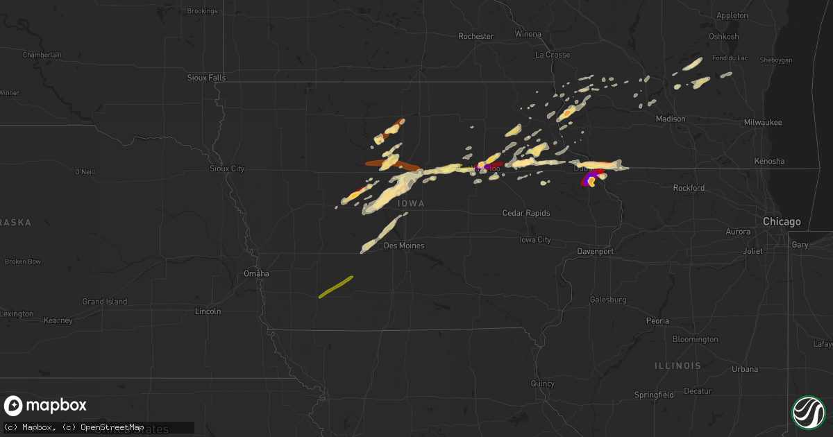
Hail Map in Iowa on April 29, 2013
Get this storm
April 29 map
$229
one time, instant access
Download today. No call, no setup
Keep the $229
Bought the map and want the full workflow? Apply the entire $229 to a subscription within 7 days. None of it is wasted.
Every map, not just this one
This buys you this map. Subscription and you get every map we run, in the markets you choose from a few cities to whole states to nationwide. Plus real-time alerts the moment a storm fires.
Contact data
Name, contact info, occupancy, even credit band for addresses in the footprint. You go from where it hit to who to call.
Become the source they trust
Unlimited branding weather history reports on demand. You already have the documented answer ready for the property owner, and you are the one who showed up with it.
Property data and RoofTrace estimates
Pull up any address you have got, its value and the exact code rules for that jurisdiction, straight from One Click Code. Then RoofTrace estimates the squares, pitch, and roof value, priced the way you price.
Storm reports in Iowa
Iowa
| Date | Description |
|---|---|
| 04/29/201312:11 PM CDT | Pea to quarter size hail. |
| 04/29/201312:10 PM CDT | A local report indicates 1.00 inch wind near 2 WNW DUBUQUE |
| 04/29/201312:02 PM CDT | Pea to quarter size hail. South of holy cross. |
| 04/29/201310:50 AM CDT | Mostly pea size hail with a few stones as large as ping pong balls. |
| 04/29/201310:48 AM CDT | From quarter to nickle size hail. From aurora to one mile south. |
| 04/29/201310:45 AM CDT | Mostly pea size hail with a few stones as large as ping pong balls. Correction to time and location based on radar. |
| 04/29/201310:37 AM CDT | Covered the ground. At 155th and olympic ave. |
| 04/29/20139:35 AM CDT | Black hawk county emergency manager reported quarter size hail |
| 04/29/20139:30 AM CDT | Measured at the pepsi plant |
| 04/29/20139:30 AM CDT | One inch wide by one half inch thick hail measured at kwwl. |
| 04/29/20139:30 AM CDT | Quarter sized hail covering the ground 2 to 3 inches deep at intersection of conger st and highway 63 |
| 04/29/20139:25 AM CDT | Trained spotter reported quarter to half dollar sized hail |
| 04/29/20139:25 AM CDT | Trained spotter estimated 2 inch diameter hail |
| 04/29/20139:23 AM CDT | Hail increased from quarter to half dollar size |
| 04/29/20139:21 AM CDT | Public reported quarter size hail |
| 04/29/20139:20 AM CDT | Hail covering the ground at the intersection of greenhill road and rainbow dr. Relayed by kcvm |
| 04/29/20139:19 AM CDT | Public reported quarter size hail |
| 04/29/20138:42 AM CDT | Quarter size hail covering the ground |
| 04/29/20137:38 AM CDT | Iowa state trooper reported quarter size hail on highway which was two inches deep |
| 04/29/20131:43 AM CDT | Public report called into the dispatch center. |
| 04/29/20131:33 AM CDT | A local report indicates 1.00 inch wind near WEST UNION |
| 04/28/201311:45 PM CDT | Hail lasted 10 minutes. Received via twitter |
| 04/28/201311:25 PM CDT | A local report indicates 1.50 inch wind near 3 NW PATON |
| 04/28/201311:21 PM CDT | Quarter to ping pong ball size hail |
| 04/28/201311:18 PM CDT | On highway 4 |
| 04/28/201310:45 PM CDT | A local report indicates 1.00 inch wind near 5 N BOONE |
| 04/28/201310:33 PM CDT | A local report indicates 1.00 inch wind near SW OGDEN |
| 04/28/201310:33 PM CDT | A local report indicates 1.00 inch wind near 2 NW OGDEN |
| 04/28/201310:05 PM CDT | A local report indicates 1.25 inch wind near SSE KANAWHA |
| 04/28/201310:02 PM CDT | Nickel to quarter sized hail |
| 04/28/201310:00 PM CDT | Report forwarded by kimt tv. |
| 04/28/20139:25 PM CDT | A local report indicates 1.50 inch wind near RENWICK |
| 04/28/20138:30 PM CDT | Golfball to tennis ball...time estimated from radar. |
| 04/28/20138:26 PM CDT | Time estimated |
| 04/28/20138:26 PM CDT | Quarter to golf ball size hail...time estimated from radar. |
| 04/28/20138:24 PM CDT | Time estimated from radar. |
All States Impacted by Hail Map on April 29, 2013
Cities Impacted by Hail Map on April 29, 2013
- Grand Haven, MI
- Iowa Falls, IA
- Prairie Du Chien, WI
- Ocala, FL
- San Diego, TX
- Alice, TX
- Monona, IA
- Harpers Ferry, IA
- Lamont, IA
- Masonville, IA
- Aurora, IA
- Dundee, IA
- Independence, IA
- Winthrop, IA
- Robstown, TX
- Woodward, IA
- Polk City, IA
- Madrid, IA
- Granger, IA
- Dallas Center, IA
- Beeville, TX
- Williams, IA
- Alden, IA
- Boone, IA
- Ogden, IA
- Stanhope, IA
- Kamrar, IA
- Ellsworth, IA
- Stratford, IA
- Blairsburg, IA
- Jewell, IA
- Radcliffe, IA
- Grand Junction, IA
- Pilot Mound, IA
- Story City, IA
- Randall, IA
- La Porte City, IA
- Waterloo, IA
- Jesup, IA
- Adel, IA
- Wellsburg, IA
- Hardeeville, SC
- West Union, IA
- Hawkeye, IA
- Fayette, IA
- Sumner, IA
- Silver Springs, FL
- Fort McCoy, FL
- Anthony, FL
- Richland Center, WI
- Hillsboro, WI
- Shiner, TX
- Yoakum, TX
- Cuero, TX
- Cedar Falls, IA
- Hudson, IA
- Arlington, IA
- Elkader, IA
- Hazleton, IA
- Strawberry Point, IA
- Galena, IL
- Shullsburg, WI
- Scales Mound, IL
- Cuba City, WI
- Hazel Green, WI
- East Dubuque, IL
- Dubuque, IA
- Goldfield, IA
- Ridgeland, SC
- Okatie, SC
- Paton, IA
- Boxholm, IA
- Dana, IA
- Freer, TX
- Port Wentworth, GA
- Hardy, IA
- Renwick, IA
- Wharton, TX
- Glen Flora, TX
- Mayville, WI
- Lomira, WI
- Brownsville, WI
- Orange Grove, TX
- Woolstock, IA
- Eagle Grove, IA
- Clarion, IA
- La Motte, IA
- Lancaster, WI
- Corpus Christi, TX
- Port Aransas, TX
- Orlando, FL
- Oviedo, FL
- Readlyn, IA
- Dunkerton, IA
- Fairbank, IA
- Evansdale, IA
- Saint Joseph, MI
- Stevensville, MI
- Bangor, MI
- Gobles, MI
- Paw Paw, MI
- Lawrence, MI
- Earlville, IA
- Pipe Creek, TX
- Hopkins, MI
- Allegan, MI
- Elgin, IA
- Wadena, IA
- Eldora, IA
- Bellevue, IA
- Zwingle, IA
- Floresville, TX
- Wauzeka, WI
- Eastman, WI
- Two Harbors, MN
- Bloomingdale, MI
- Randolph, WI
- Sauk City, WI
- George West, TX
- Cambria, WI
- Markesan, WI
- Manchester, IA
- Fort Dodge, IA
- Churdan, IA
- Lehigh, IA
- Gowrie, IA
- Dayton, IA
- Scranton, IA
- Harcourt, IA
- Jefferson, IA
- Montague, MI
- Whitehall, MI
- Garner, IA
- Klemme, IA
- Ravenna, MI
- Hopkinton, IA
- Ryan, IA
- Willow City, TX
- Hallettsville, TX
- Schulenburg, TX
- Guttenberg, IA
- Falls City, TX
- Poth, TX
- Fox Lake, WI
- Fall River, WI
- Burnett, WI
- Beaver Dam, WI
- Columbus, WI
- Kanawha, IA
- Woodman, WI
- Mount Hope, WI
- Big Falls, MN
- Littlefork, MN
- Lorida, FL
- Lake Placid, FL
- Steuben, WI
- Hondo, TX
- Fredericksburg, TX
- Dyersville, IA
- Greeley, IA
- New Vienna, IA
- Matagorda, TX
- Bay City, TX
- Orangeburg, SC
- Cameron, SC
- Elkport, IA
- Edgewood, IA
- Otho, IA
- Viola, WI
- Mazomanie, WI
- Llano, TX
- Lawton, MI
- Decatur, MI
- Baraboo, WI
- Soldiers Grove, WI
- Readstown, WI
- Hartford, MI
- Bitely, MI
- Loganville, WI
- North Freedom, WI
- Plain, WI
- Bishop, TX
- Kingsville, TX
- Apple River, IL
- Bluffton, SC
- Beaufort, SC
- Coopersville, MI
- Nunica, MI
- Fruitport, MI
- Devine, TX
- Redfield, IA
- Earlham, IA
- Dexter, IA
- Steamboat Rock, IA
- Aplington, IA
- Parkersburg, IA
- Ackley, IA
- Minburn, IA
- Kelley, IA
- Green Pond, SC
- Floodwood, MN
- Wright, MN
- Glidden, IA
- Ferryville, WI
- Webster City, IA
- Viroqua, WI
- La Farge, WI
- Blanco, TX
- East Bernard, TX
- Glennville, GA
- De Soto, WI
- Pearsall, TX
- Allendale, MI
- Jenison, MI
- Grand Rapids, MI
- Hudsonville, MI
- San Antonio, TX
- Laredo, TX
- San Marcos, TX
- Shelby, MI
- Edna, TX
- Palm Coast, FL
- Calliham, TX
- Benton, WI
- Saint Olaf, IA
- Farmersburg, IA
- Dike, IA
- Helotes, TX
- Bertram, TX
- Kendalia, TX
- Saint Marys, GA
- Fernandina Beach, FL
- Yulee, FL
- Homerville, GA
- Rio, WI
- Maynard, IA
- Oelwein, IA
- Belmond, IA
- Duncombe, IA
- Stuart, IA
- Coggon, IA
- Volga, IA
- Britt, IA
- Austin, TX
- Clyo, GA
- Eagle Lake, TX
- Nashua, IA
- Reedsburg, WI
- Longwood, FL
- Apopka, FL
- Rippey, IA
- Beaver, IA
- Blue River, WI
- McGregor, IA
- Marquette, IA
- Boscobel, WI
- Gays Mills, WI
- Cassville, WI
- Bloomington, WI
- Midfield, TX
- West Olive, MI
- Holland, MI
- Okeechobee, FL
- Randalia, IA
- Durango, IA
- Lodi, WI
- Marble Falls, TX
- Garnett, SC
- Tillman, SC
- Pineland, SC
- Stanley, IA
- Pooler, GA
- Bloomingdale, GA
- Guyton, GA
- Holy Cross, IA
- Sherrill, IA
- Bagley, WI
- Spring Lake, MI
- Flagler Beach, FL
- Lake Mary, FL
- Cotulla, TX
- Labelle, FL
- Newaygo, MI
- Berrien Springs, MI
- Berrien Center, MI
- Taft, TX
- Ames, IA
- Encinal, TX
- Holland, IA
- Harrison, AR
- Huxley, IA
- Ripon, WI
- Dalton, WI
- Warren, IL
- Waterville, IA
- Waukon, IA
- Grant, MI
- Rothbury, MI
- Holton, MI
- Muskegon, MI
- Zeeland, MI
- Buda, TX
- Fargo, GA
- Mims, FL
- Postville, IA
- Quasqueton, IA
- Rowley, IA
- Comstock Park, MI
- Marne, MI
- Moore Haven, FL
- Clewiston, FL
- Stockdale, TX
- Sanford, FL
- Portage, WI
- Pardeeville, WI
- Cedar Springs, MI
- Deland, FL
- Janesville, IA
- Shell Rock, IA
- New Hartford, IA
- Hesperia, MI
- Twin Lake, MI
- Fremont, MI
- Odum, GA
- Ossian, IA
- Decorah, IA
- Cazenovia, WI
- Hubbard, IA
- Rincon, GA
- Laurel Hill, FL
- Garnavillo, IA
- Hobson, TX
- Brandon, WI
- Dorchester, IA
- Waverly, IA
- Springfield, GA
- Lansing, IA
- Castalia, IA
- Dowagiac, MI
- Winter Park, FL
- Walkerville, MI
- Blessing, TX
- Markham, TX
- Colesburg, IA
- Humboldt, IA
- Bernard, IA
- Whitsett, TX
- Metairie, LA
- New Orleans, LA
- Dewar, IA
- Dows, IA
- Badger, IA
- Vincent, IA
- Goodell, IA
- Stout, IA
- Prescott, IA
- Carbon, IA
- Orient, IA
- Creston, IA
- Villisca, IA
- Corning, IA
- Bridgewater, IA
- Nodaway, IA


