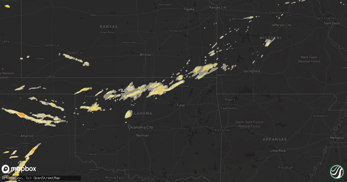
Hail Map in Texas on April 29, 2012
Get this storm
April 29 map
$229
one time, instant access
Download today. No call, no setup
Keep the $229
Bought the map and want the full workflow? Apply the entire $229 to a subscription within 7 days. None of it is wasted.
Every map, not just this one
This buys you this map. Subscription and you get every map we run, in the markets you choose from a few cities to whole states to nationwide. Plus real-time alerts the moment a storm fires.
Contact data
Name, contact info, occupancy, even credit band for addresses in the footprint. You go from where it hit to who to call.
Become the source they trust
Unlimited branding weather history reports on demand. You already have the documented answer ready for the property owner, and you are the one who showed up with it.
Property data and RoofTrace estimates
Pull up any address you have got, its value and the exact code rules for that jurisdiction, straight from One Click Code. Then RoofTrace estimates the squares, pitch, and roof value, priced the way you price.
Storm reports in Texas
Texas
| Date | Description |
|---|---|
| 04/29/20121:30 AM CDT | A local report indicates 1.00 inch wind near 6 N PAMPA |
| 04/29/20121:20 AM CDT | Wind damage to roof...power line...and fence reported in pampa |
| 04/29/201212:33 AM CDT | Dime to nickel size hail accumulated two inches deep. |
| 04/29/201212:30 AM CDT | Quarter size hail reported in borger |
| 04/29/201212:30 AM CDT | A local report indicates 1.25 inch wind near BORGER |
| 04/29/201212:30 AM CDT | Golf ball size hail reported in borger |
| 04/29/201212:28 AM CDT | A local report indicates 1.00 inch wind near BORGER |
| 04/29/201212:00 AM CDT | A local report indicates 1.00 inch wind near 4 N MIAMI |
| 04/28/201211:49 PM CDT | Golfball hail reported in tahoka. |
| 04/28/201211:33 PM CDT | A local report indicates 2.75 inch wind near DUMAS |
| 04/28/201211:31 PM CDT | Fences blown down at 1585 and 3261... 50-60 head of cattle lose on road |
| 04/28/201211:28 PM CDT | A local report indicates 1.75 inch wind near DUMAS |
| 04/28/201211:27 PM CDT | A local report indicates 60 MPH wind near HIGGINS |
| 04/28/201211:17 PM CDT | A local report indicates 1.75 inch wind near 8 W DUMAS |
| 04/28/201211:15 PM CDT | A local report indicates 2.00 inch wind near TAHOKA |
| 04/28/201211:12 PM CDT | A local report indicates 1.75 inch wind near TAHOKA |
| 04/28/201210:55 PM CDT | Delayed report from april 29 |
| 04/28/201210:38 PM CDT | A local report indicates 1.00 inch wind near 1 SE ROPESVILLE |
| 04/28/201210:29 PM CDT | A local report indicates 1.75 inch wind near SOUTHLAND |
| 04/28/201210:17 PM CDT | 179 and 211 |
| 04/28/201210:15 PM CDT | A local report indicates 1.00 inch wind near 2 N BORGER |
| 04/28/201210:12 PM CDT | A local report indicates 1.00 inch wind near 1 S SLATON |
| 04/28/201210:09 PM CDT | Covering ground |
| 04/28/201210:04 PM CDT | On 41 |
| 04/28/20129:50 PM CDT | Heavy flooding along with hail |
| 04/28/20129:38 PM CDT | Windshield destroyed |
| 04/28/20129:35 PM CDT | A local report indicates 1.00 inch wind near 5 E SPEARMAN |
| 04/28/20129:33 PM CDT | Severe hail damage to residences and automobiles along fm 41 west of us 87 |
| 04/28/20129:33 PM CDT | A local report indicates 1.75 inch wind near 3 SE WOODROW |
| 04/28/20129:31 PM CDT | Lost windshield to baseball hail just east of highway 87 on 41. |
| 04/28/20129:31 PM CDT | Lost windshield to baseballhail 3 mi wsw union |
| 04/28/20129:30 PM CDT | Three power poles down northeast of intersection of u.s. 385 and fm41. |
| 04/28/20129:20 PM CDT | Small tree limbs down around spearman |
| 04/28/20129:12 PM CDT | 154th and indiana |
| 04/28/20129:09 PM CDT | A local report indicates 1.00 inch wind near 3 SE GRUVER |
| 04/28/20129:00 PM CDT | Three power poles down west of u.s. 62 and 82 along foster rd. |
| 04/28/20129:00 PM CDT | Observed by west texas mesonet site. |
| 04/28/20128:55 PM CDT | Trees uprooted and roof off of a home. Mobile home also lost roof. Estimated winds 80-90 mph. |
| 04/28/20128:55 PM CDT | Recorded by west texas mesonet station. |
| 04/28/20128:51 PM CDT | Spotter report at 93rd and milwaukee |
| 04/28/20128:51 PM CDT | Reported at 93rd and milwaykee. |
| 04/28/20128:25 PM CDT | A local report indicates 2.50 inch wind near 6 NNW ROPESVILLE |
| 04/28/20128:22 PM CDT | A local report indicates 1.50 inch wind near SMYER |
| 04/28/20128:15 PM CDT | A local report indicates 1.75 inch wind near 6 NNW ROPESVILLE |
| 04/28/20127:58 PM CDT | Power poles down 2 miles east of levelland on highway 114. |
| 04/28/20127:56 PM CDT | A local report indicates 2.75 inch wind near 4 SSW WHITHARRAL |
| 04/28/20127:35 PM CDT | Golfball hail reported in littlefield. Relayed by viewer to kcbd. |
All States Impacted by Hail Map on April 29, 2012
Cities Impacted by Hail Map on April 29, 2012
- Pampa, TX
- Deerfield, MO
- Moundville, MO
- Nevada, MO
- Springer, NM
- Waynoka, OK
- Cleo Springs, OK
- Fieldton, TX
- Littlefield, TX
- Laddonia, MO
- Altoona, KS
- Idalia, CO
- Kirk, CO
- Pawnee, OK
- Red Rock, OK
- Ponca City, OK
- Fairfax, OK
- Marland, OK
- Ralston, OK
- Wynona, OK
- Pawhuska, OK
- Dodge City, KS
- Cimarron, KS
- Ensign, KS
- Montezuma, KS
- Nazareth, TX
- Dimmitt, TX
- Hereford, TX
- Clayton, NM
- Farlington, KS
- Fort Scott, KS
- Garland, KS
- Hunter, OK
- Enid, OK
- Kremlin, OK
- Borger, TX
- La Monte, MO
- Hughesville, MO
- Sedalia, MO
- Vernon, CO
- Hale Center, TX
- Kress, TX
- Olton, TX
- Plainview, TX
- Wolfforth, TX
- Lubbock, TX
- Lorenzo, TX
- Justiceburg, TX
- Levelland, TX
- Shallowater, TX
- Meadow, TX
- Ropesville, TX
- Smyer, TX
- Post, TX
- Wilson, TX
- Snyder, TX
- Ralls, TX
- Slaton, TX
- Tahoka, TX
- Wayside, TX
- Tulia, TX
- Happy, TX
- La Belle, MO
- Lewistown, MO
- Spearman, TX
- Manter, KS
- Lockwood, MO
- Friona, TX
- Summerfield, TX
- Dumas, TX
- Pep, TX
- Crosbyton, TX
- Amherst, TX
- Brownfield, TX
- Sudan, TX
- Hart, TX
- Enochs, TX
- Urich, MO
- Elk City, KS
- Nash, OK
- Carmen, OK
- Aline, OK
- Buffalo, OK
- Copan, OK
- Bartlesville, OK
- Dewey, OK
- Buffalo, MO
- Linn Creek, MO
- Montreal, MO
- Camdenton, MO
- Johnson, KS
- Carlinville, IL
- Lincoln, MO
- Windsor, MO
- Rush Hill, MO
- Stratton, CO
- Brumley, MO
- Tuscumbia, MO
- Ulman, MO
- Iberia, MO
- Douglas, OK
- Canadian, TX
- Gruver, TX
- Niotaze, KS
- Caney, KS
- Peru, KS
- Minneola, KS
- Louisiana, MO
- Pleasant Hill, IL
- Rockport, IL
- Anton, TX
- Earth, TX
- Springlake, TX
- Claude, TX
- Morton, TX
- Rosamond, IL
- Oconee, IL
- Irving, IL
- Pana, IL
- Nokomis, IL
- Witt, IL
- Ramsey, IL
- Perryton, TX
- Hartley, TX
- Dalhart, TX
- Pond Creek, OK
- Medford, OK
- Newark, MO
- Knox City, MO
- Dover, OK
- Kingfisher, OK
- Okarche, OK
- Grimesland, NC
- Greenville, NC
- Novelty, MO
- Monticello, MO
- Leonard, MO
- Independence, KS
- Stinnett, TX
- Fillmore, IL
- Stratford, TX
- Texhoma, OK
- Goodwell, OK
- Carthage, MO
- Jasper, MO
- Golden City, MO
- Fargo, OK
- Briscoe, TX
- Butler, MO
- Ringwood, OK
- Helena, OK
- Hugo, CO
- Mooreland, OK
- Vici, OK
- Camargo, OK
- Havana, KS
- Taloga, OK
- Tonkawa, OK
- Kaw City, OK
- Cedar Vale, KS
- Sedan, KS
- Ford, KS
- Skellytown, TX
- Fritch, TX
- Sunray, TX
- Miami, TX
- Fairmont, OK
- West Mineral, KS
- Oswego, KS
- Edna, KS
- Weir, KS
- Welch, OK
- Asbury, MO
- Bartlett, KS
- Columbus, KS
- Cherokee, KS
- Pittsburg, KS
- Chetopa, KS
- McCune, KS
- Mindenmines, MO
- Scammon, KS
- Coffeyville, KS
- Altamont, KS
- Dennis, KS
- Cherryvale, KS
- Mound Valley, KS
- Parsons, KS
- Quincy, IL
- Payson, IL
- Palmyra, MO
- Half Way, MO
- Louisburg, MO
- Bucklin, KS
- Lamont, OK
- Lakewood, IL
- Bethune, CO
- Pleasant Hope, MO
- Fair Grove, MO
- Knob Noster, MO
- Nardin, OK
- Blackwell, OK
- Louisburg, KS
- Callao, MO
- Huntsville, MO
- Excello, MO
- Mullinville, KS
- Protection, KS
- Sedan, NM
- Arnett, OK
- El Dorado Springs, MO
- Sunrise Beach, MO
- Osage Beach, MO
- Kaiser, MO
- Meno, OK
- Lahoma, OK
- May, OK
- Laverne, OK
- Shattuck, OK
- Walker, MO
- Richards, MO
- Appleton City, MO
- Rockville, MO
- Rantoul, KS
- Osawatomie, KS
- Lane, KS
- Sharon, OK
- Leedey, OK
- Mutual, OK
- Fairview, OK
- Hennessey, OK
- Wakita, OK
- Girard, KS
- S Coffeyville, OK
- Liberty, KS
- Galena, KS
- Lenapah, OK
- Thompson, MO
- Centralia, MO
- Mexico, MO
- Ingalls, KS
- Bowling Green, MO
- Fulton, KS
- Prescott, KS
- Hume, MO
- Belhaven, NC
- Pantego, NC
- Bronaugh, MO
- Vandalia, MO
- Newkirk, OK
- Kismet, KS
- Springfield, CO
- Green Ridge, MO
- Burbank, OK
- Shidler, OK
- Anabel, MO
- Macon, MO
- Garber, OK
- Guymon, OK
- Kingsville, MO
- Tower Hill, IL
- Dacoma, OK
- Chester, OK
- South Greenfield, MO
- Wann, OK
- Harwood, MO
- Dawson, IL
- Mechanicsburg, IL
- Rochester, IL
- Winchester, IL
- Long Lane, MO
- Lebanon, MO
- Phillipsburg, MO
- Walnut, KS
- Durham, OK
- Canton, OK
- Seiling, OK
- Bolivar, MO
- Raton, NM
- El Reno, OK
- Sarcoxie, MO
- Charleston, IL
- Hillsboro, IL
- Bingham, IL
- Columbia, MO
- Ashland, MO
- Carthage, IL
- Litchfield, IL
- Raymond, IL
- Butler, IL
- Carrier, OK
- Shelbyville, IL
- Liberal, MO
- Mulberry, KS
- Muleshoe, TX
- Creighton, MO
- Virden, IL
- Modesto, IL
- Waverly, IL
- Neodesha, KS
- Clinton, MO
- Bison, OK
- Mapleton, KS
- Cheyenne, OK
- Lamar, MO
- Billings, OK
- Union City, OK
- Perry, OK
- Jet, OK
- Goltry, OK
- Schell City, MO
- Foster, MO
- Follett, TX
- Fulton, MO
- Alva, OK
- Pittsfield, IL
- Calumet, OK
- Waukomis, OK
- Sturgeon, MO
- Oronogo, MO
- Panhandle, TX
- Arcadia, KS
- Hepler, KS
- Pilot Grove, MO
- Curryville, MO
- Roach, MO


