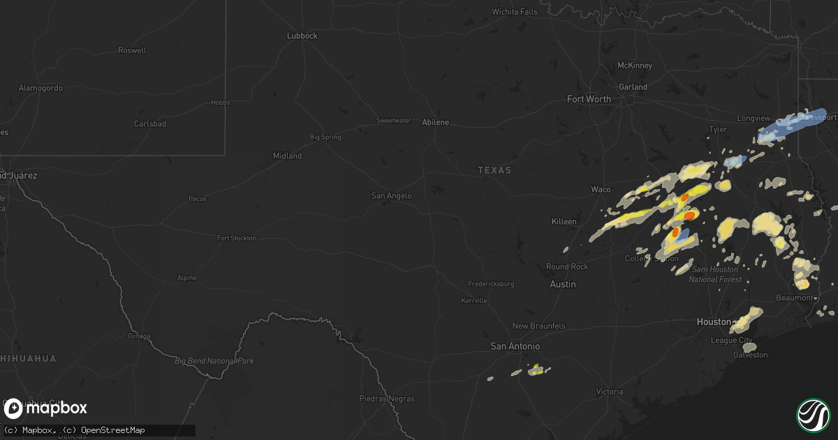
Hail Map in Texas on April 28, 2024
Get this storm
April 28 map
$229
one time, instant access
Download today. No call, no setup
Keep the $229
Bought the map and want the full workflow? Apply the entire $229 to a subscription within 7 days. None of it is wasted.
Every map, not just this one
This buys you this map. Subscription and you get every map we run, in the markets you choose from a few cities to whole states to nationwide. Plus real-time alerts the moment a storm fires.
Contact data
Name, contact info, occupancy, even credit band for addresses in the footprint. You go from where it hit to who to call.
Become the source they trust
Unlimited branding weather history reports on demand. You already have the documented answer ready for the property owner, and you are the one who showed up with it.
Property data and RoofTrace estimates
Pull up any address you have got, its value and the exact code rules for that jurisdiction, straight from One Click Code. Then RoofTrace estimates the squares, pitch, and roof value, priced the way you price.
Storm reports in Texas
Texas
| Date | Description |
|---|---|
| 04/28/20246:56 PM CDT | Trees and power lines down. |
| 04/28/20246:42 PM CDT | Numerous trees were downed throughout northern panola county. |
| 04/28/20246:35 PM CDT | Numerous trees and power lines down. |
| 04/28/20246:35 PM CDT | Trees and power lines down. |
| 04/28/20246:35 PM CDT | Multiple large trees down. |
| 04/28/20246:35 PM CDT | A tree was blown down onto a home in carthage. |
| 04/28/20246:21 PM CDT | Power lines and trees were downed in and around the bedias area... Along fm 1696... Cr 125 and cr 115. |
| 04/28/20246:21 PM CDT | Three power poles downed approximately two miles west of bedias. |
| 04/28/20246:15 PM CDT | Golf ball sized hail was observed along cr 3180. |
| 04/28/20246:14 PM CDT | Multiple trees down on fm 1798 near pine hill community. |
| 04/28/20246:12 PM CDT | Several power poles reported down across town per city marshall and county em. |
| 04/28/20245:59 PM CDT | Emergency manager reports large tree down on fm road 840 near pecan creek and on fm road 13 just inside loop 571. Both in the city of henderson. |
| 04/28/20245:57 PM CDT | Tree down 10500 fm road 839 south... Near county road 458. |
| 04/28/20245:55 PM CDT | Tree across fm road 1798 at w fork angelina river... West of laneville community. |
| 04/28/20245:45 PM CDT | A 59 mph wind gusts recorded at lake striker from texas water development board mesonet station. Also... Rusk coounty em reports tree down on 15000 black of cr 4255 in |
| 04/28/20245:24 PM CDT | Multiple trees were blown down across the northern and central sections of cherokee county. |
| 04/28/20245:00 PM CDT | Trees were damaged... Snapped... And uprooted around lost prairie lake. |
| 04/28/20244:58 PM CDT | Trained spotter reports via amateur radio of quarter sized hail. |
| 04/28/20243:47 PM CDT | A second ef-0 tornado developed on the east side of us-highway 75s near the town of dew. Multiple tree damage was found along the e fm 489 road. The tornado continued t |
| 04/28/20243:35 PM CDT | An ef-0 tornado developed southwest of dew along w fm 489 road. Several trees sustained significant damage with large limbs and uprooted trees. No visible damage was fo |
| 04/28/20243:08 PM CDT | Tornado was verified by storm spotter video but area is inaccessible. In the video... Tree limbs were seen being lofted in the air. |
| 04/28/20243:02 PM CDT | Hail of 1 to 1.25 inches. Relayed by emergency management. |
| 04/28/20242:50 PM CDT | A short-lived ef-0 tornado occurred east of highway 77 in burlington... Damaging a small shed on one property and a few uninhabited mobile homes on a neighboring proper |
| 04/28/20241:50 PM CDT | Quarter sized hail at the poth fire department. |
| 04/28/20241:45 PM CDT | Public reports quarter sized hail near the intersection of highway 181 and westmeyer street. |
| 04/28/20241:10 PM CDT | Trained spotter reports quarter sized hail near the intersection of highways 97 and 181. |
| 04/28/20248:39 AM CDT | Roof damage to a home near shadow glenn elementary. Time estimated via radar. |
| 04/28/20248:35 AM CDT | Emergency manager sent pictures of a billboard blown over and an ac unit blown off the roof of a convenience store in manor. Time estimated from radar. |
| 04/28/20248:31 AM CDT | A tornado caused damage along a 4.8 mile path from 2 miles wsw of manor to 3 miles ne of manor. One house had significant roof damage rated ef-1. Other damage included |
| 04/28/20248:10 AM CDT | Corrects previous tstm wnd dmg report from 1 se sunset valley. Picture of snapped power pole shared by a utility company on social media. Street view is of around the 1 |
| 04/28/20248:09 AM CDT | Several downed trees and tree damage within garrison park. Time estimated via radar. |
| 04/28/20248:05 AM CDT | Wind damage with large tree snapped at manchaca and wm cannon rd. |
| 04/28/20247:10 AM CDT | Picture of snapped power pole shared by a utility company on social media. Street view is of around the 1600 block of w. Stassney ln. |
| 04/28/20244:10 AM CDT | Public reports a little bigger than quarters. This was on the edge of the core. |
| 04/28/20244:08 AM CDT | Video received of penny to quarter size hail near mauriceville. Time estimated by radar. |
| 04/28/20244:00 AM CDT | Photo received of 1 inch size hail near gist. Time estimated by radar. |
| 04/28/20241:11 AM CDT | Report of trees down across fm 2827. Time estimated by radar. |
| 04/28/202412:05 AM CDT | Trees down on hwy 190 near dam b. Time estimated by radar. |
| 04/27/202411:40 PM CDT | Tree down on rr255 between colmesneil and hwy 63. |
| 04/27/202411:30 PM CDT | A tree was blown down across highway 83 just west of pineland near bear creek. A car drove into the tree and crashed... But fortunately... There were no injuries. |
| 04/27/202410:49 PM CDT | Trees were blown down on fm 2213 just south of san augustine. |
| 04/27/202410:47 PM CDT | A tree was blown down across fm 711 just northwest of san augustine. |
| 04/27/202410:42 PM CDT | A tree was blown down across fm 2558 near broaddus. |
| 04/27/202410:06 PM CDT | Multiple trees were downed across angelina county. |
| 04/27/20249:40 PM CDT | Wind gust occurred at the sh 75 s tempest weather station site. |
| 04/27/20249:35 PM CDT | Corrects previous tstm wnd dmg report from timpson. Trees and power lines down. |
| 04/27/20249:33 PM CDT | Multiple trees and power lines were downed across shelby county. |
| 04/27/20249:25 PM CDT | Several large trees were downed on highway 94. |
| 04/27/20249:10 PM CDT | A tree was downed along cr 381 southeast of martinsville. |
| 04/27/20248:56 PM CDT | Trees and power lines down. |
| 04/27/20248:56 PM CDT | Trees and power li |
| 04/27/20248:45 PM CDT | Wind gust occurred at a tempest weather system site. |
| 04/27/20248:40 PM CDT | Straight line winds caused widespread tree damage as well as some roof and awning damage along fm 2262. Time estimated based on radar. |
| 04/27/20248:30 PM CDT | Multiple trees were downed across nacogdoches county. |
| 04/27/20248:30 PM CDT | Trees down. |
| 04/27/20248:25 PM CDT | Large tree on road at intersection of fm road 3135 at county road 336. |
| 04/27/20248:05 PM CDT | *** 2 inj *** corrects previous tstm wnd dmg report from 4 ese trinity. Survey team indicates ef1 tornado damage. Home damaged in the rock creek subdivision off of fm 3 |
| 04/27/20248:05 PM CDT | *** 2 inj *** home damaged in the rock creek subdivision off of fm 356 west of sebastopol. Two injuries reported. Time estimated on radar and subject to change. |
| 04/27/20248:03 PM CDT | Trees down. |
| 04/27/20247:35 PM CDT | *** 2 inj *** corrects previous tornado report from 4 ese trinity. Survey team indicated ef1 tornado damage. Home destroyed in the rock creek subdivision off of fm 356 |
| 04/27/20247:19 PM CDT | Tree downed on highway 90 south of madisonville. |
| 04/27/20247:06 PM CDT | Golf ball sized hail was observed in the cottonwood area. |
| 04/27/20247:00 PM CDT | Trees and power lines down. |
Cities Impacted by Hail Map on April 28, 2024
- Buckley, MI
- Kingsley, MI
- Fife Lake, MI
- South Boardman, MI
- Pleasanton, TX
- Floresville, TX
- Moore, TX
- Bigfoot, TX
- Poteet, TX
- Poth, TX
- Georgetown, TX
- Chilton, TX
- Falls City, TX
- Riesel, TX
- Marlin, TX
- Groesbeck, TX
- Rogers, TX
- Mart, TX
- Kosse, TX
- Thornton, TX
- Stockdale, TX
- Eddy, TX
- Rosebud, TX
- Lott, TX
- Burlington, TX
- Buckholts, TX
- Holland, TX
- Bartlett, TX
- Mexia, TX
- Bremond, TX
- Reagan, TX
- Teague, TX
- Fairfield, TX
- Buffalo, TX
- Oakwood, TX
- Calvert, TX
- Donie, TX
- Palestine, TX
- Tennessee Colony, TX
- Jewett, TX
- Franklin, TX
- Jacksonville, TX
- Montalba, TX
- Marquez, TX
- Troup, TX
- Frankston, TX
- Centerville, TX
- Hearne, TX
- Elkhart, TX
- Somerville, TX
- Mcalester, OK
- Tulsa, OK
- Normangee, TX
- Rusk, TX
- Canadian, OK
- Broken Arrow, OK
- Grapeland, TX
- College Station, TX
- Leona, TX
- Reklaw, TX
- Anderson, TX
- Laneville, TX
- Owasso, OK
- Madisonville, TX
- Henderson, TX
- Iola, TX
- Bryan, TX
- Cushing, TX
- Mount Enterprise, TX
- Tatum, TX
- Crockett, TX
- Beckville, TX
- North Zulch, TX
- Lovelady, TX
- Bedias, TX
- Alto, TX
- Carthage, TX
- Long Branch, TX
- Marshall, TX
- Shreveport, LA
- Waskom, TX
- Greenwood, LA
- De Berry, TX
- Jenks, OK
- Union City, OK
- Wells, TX
- Mooringsport, LA
- Karnack, TX
- Blanchard, LA
- Midway, TX
- Trinity, TX
- Huntsville, TX
- Heavener, OK
- Tenaha, TX
- Groveton, TX
- Flint, TX
- Billings, MO
- Clever, MO
- Edmond, OK
- Joaquin, TX
- Nacogdoches, TX
- Meridian, OK
- Guthrie, OK
- Luther, OK
- Wellston, OK
- San Augustine, TX
- Center, TX
- Chireno, TX
- Corrigan, TX
- Wortham, TX
- Diboll, TX
- Huntington, TX
- Lufkin, TX
- Navasota, TX
- Chester, TX
- Alpena, AR
- Green Forest, AR
- Zavalla, TX
- Mcloud, OK
- Oakhurst, TX
- Shawnee, OK
- Plantersville, TX
- Colmesneil, TX
- Jasper, TX
- Montgomery, TX
- Woodville, TX
- Richards, TX
- Milam, TX
- Hemphill, TX
- Bronson, TX
- Brookeland, TX
- Broaddus, TX
- Coldspring, TX
- Pointblank, TX
- Hillister, TX
- Pennington, TX
- Collinsville, OK
- Livingston, TX
- Shepherd, TX
- Goodrich, TX
- Florien, LA
- Anacoco, LA
- Hornbeck, LA
- Kirbyville, TX
- Spurger, TX
- Fred, TX
- Silsbee, TX
- Buna, TX
- Cleveland, TX
- Georgetown, LA
- Alexandria, LA
- Pineville, LA
- Boyce, LA
- Olla, LA
- Willis, TX
- New Waverly, TX
- Tullos, LA
- Call, TX
- Bon Wier, TX
- New Caney, TX
- La Porte, TX
- Pasadena, TX
- Baytown, TX
- Dayton, TX
- Deridder, LA
- Vidor, TX
- Wallisville, TX
- Deweyville, TX
- Liberty, TX
- Anahuac, TX
- Orange, TX
- Sulphur, LA
- Vinton, LA
- Hankamer, TX
- Seabrook, TX
- Houston, TX
- Devers, TX
- Bethany, LA
- Keithville, LA
- Bossier City, LA
- Barksdale Afb, LA
- Haughton, LA
- Texas City, TX
- Port Bolivar, TX
- Cameron, LA
- Manor, TX
- Plain Dealing, LA
- Bradley, AR


