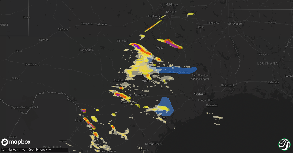
Hail Map on April 28, 2023
Get this storm
April 28 map
$229
one time, instant access
Download today. No call, no setup
Keep the $229
Bought the map and want the full workflow? Apply the entire $229 to a subscription within 7 days. None of it is wasted.
Every map, not just this one
This buys you this map. Subscription and you get every map we run, in the markets you choose from a few cities to whole states to nationwide. Plus real-time alerts the moment a storm fires.
Contact data
Name, contact info, occupancy, even credit band for addresses in the footprint. You go from where it hit to who to call.
Become the source they trust
Unlimited branding weather history reports on demand. You already have the documented answer ready for the property owner, and you are the one who showed up with it.
Property data and RoofTrace estimates
Pull up any address you have got, its value and the exact code rules for that jurisdiction, straight from One Click Code. Then RoofTrace estimates the squares, pitch, and roof value, priced the way you price.
States Impacted by Hail Map on April 28, 2023
Storm reports
Texas
| Date | Description |
|---|---|
| 04/28/20236:59 PM CDT | Report from mping quarter |
| 04/28/20236:45 PM CDT | Up to 1 inch hail in olmos park. |
| 04/28/20236:38 PM CDT | 1.5 in hail reported near mexia. |
| 04/28/20236:36 PM CDT | Em reports golf ball size hail 7 miles south of mexia. |
| 04/28/20236:35 PM CDT | Emergency management reports quarter size hail in giddings. |
| 04/28/20236:34 PM CDT | Social media photo shows hail north of alba along lake fork. |
| 04/28/20236:31 PM CDT | Report from mping quarter |
| 04/28/20236:25 PM CDT | Personal weather station recorded a 75 mph gust at bird pond at rock prairie rd. |
| 04/28/20236:25 PM CDT | Up to quarter size hail near the rim. |
| 04/28/20236:24 PM CDT | A local report indicates 1.25 inch wind near HELOTES |
| 04/28/20236:23 PM CDT | Golf ball sized hail reported in grey forest by a sherriffs deputy. Report relayed via emergency management. |
| 04/28/20236:20 PM CDT | Oak tree blown down at the village of rock prairie on mortier dr in college station. |
| 04/28/20236:20 PM CDT | Nickle to quarter size hail. |
| 04/28/20236:20 PM CDT | Public reports quarter size hail at the dominion shopping center. Time estimated from radar. |
| 04/28/20236:20 PM CDT | Report from mping quarter |
| 04/28/20236:18 PM CDT | A local report indicates 1.10 inch wind near HELOTES |
| 04/28/20236:16 PM CDT | A local report indicates 1.00 inch wind near 1 W LEON SPRINGS |
| 04/28/20236:13 PM CDT | Facebook report of quarter size hail. |
| 04/28/20236:13 PM CDT | Report from mping quarter |
| 04/28/20236:10 PM CDT | Tree blown down. |
| 04/28/20236:07 PM CDT | Intersection of deep hollow and highway 46. |
| 04/28/20236:05 PM CDT | Large oak tree limbs blown into the street and on a car on wayside dr in bryan. |
| 04/28/20236:05 PM CDT | Large trees blocking koppe bridge road near wellborn. |
| 04/28/20236:00 PM CDT | Mesonet station 1757w texas a&m kyle field. |
| 04/28/20236:00 PM CDT | Downed tree at the villas of rock prairie apartment complex. |
| 04/28/20235:59 PM CDT | Medium size limbs blown down and across railroad tracks. |
| 04/28/20235:55 PM CDT | Report from mping: quarter |
| 04/28/20235:55 PM CDT | Large tree downed in bryan. |
| 04/28/20235:54 PM CDT | Ham radio spotter reports ping-pong ball sized hail in hubbard. |
| 04/28/20235:49 PM CDT | Emergency manager reports quarter sized hail 3 miles south of pipe creek. |
| 04/28/20235:47 PM CDT | Report from mping: quarter |
| 04/28/20235:42 PM CDT | Time estimated via radar. |
| 04/28/20235:41 PM CDT | A local report indicates 1.00 inch wind near COMFORT |
| 04/28/20235:40 PM CDT | A local report indicates 1.00 inch wind near BANDERA |
| 04/28/20235:30 PM CDT | Corrects previous hail report from bandera. Trained storm spotter reports golf ball size hail in downtown bandera at 530 pm cdt. |
| 04/28/20235:28 PM CDT | Egg size hail. Time estimated via radar. |
| 04/28/20235:25 PM CDT | Quarter size hail near harris branch at 5:25 pm. |
| 04/28/20235:14 PM CDT | A local report indicates 1.00 inch wind near 1 SE JOLLYVILLE |
| 04/28/20235:11 PM CDT | A local report indicates 1.00 inch wind near 1 WSW JOLLYVILLE |
| 04/28/20235:09 PM CDT | A local report indicates 1.00 inch wind near WELLS BRANCH |
| 04/28/20235:08 PM CDT | A local report indicates 1.50 inch wind near 2 SW JOLLYVILLE |
| 04/28/20235:08 PM CDT | Report from mping quarter |
| 04/28/20235:07 PM CDT | Report from mping ping pong ball |
| 04/28/20235:03 PM CDT | At intersection of i-35 and tollway 45. |
| 04/28/20234:53 PM CDT | Report from mping quarter |
| 04/28/20234:52 PM CDT | Report from mping quarter |
| 04/28/20234:46 PM CDT | Golf ball size hail reported near jarrell via ham radio operator. |
| 04/28/20234:45 PM CDT | Report of quarter size hail on the west side of georgetown. |
| 04/28/20234:43 PM CDT | Report from mping: quarter |
| 04/28/20234:42 PM CDT | Report from mping quarter |
| 04/28/20234:41 PM CDT | Report from mping quarter |
| 04/28/20234:37 PM CDT | Estimate of golf ball size hail via kabb viewer report. |
| 04/28/20234:33 PM CDT | Half dollar size hail estimated via phone call 1.2 miles north of liberty hill. |
| 04/28/20234:31 PM CDT | A local report indicates 1.75 inch wind near 10 SE TROY |
| 04/28/20234:26 PM CDT | Report from mping quarter |
| 04/28/20234:25 PM CDT | Ham radio report of nickel to quarter-sized hail at 447 fm 1772 west of rosebud. |
| 04/28/20234:25 PM CDT | Report from mping quarter |
| 04/28/20234:22 PM CDT | Report from mping: quarter |
| 04/28/20234:09 PM CDT | A local report indicates 1.25 inch wind near KEENE |
| 04/28/20234:09 PM CDT | Trained spotter reported quarter-sized hail at highway 360 and park row drive in arlington. |
| 04/28/20234:05 PM CDT | Time estimated. Via facebook user photo. |
| 04/28/20233:57 PM CDT | Ham radio report of quarter-sized hail 1 mile west of cleburne. |
| 04/28/20233:55 PM CDT | Trained spotter reported wind damage 4 miles wnw of temple. 5-6 inch tree branches broken. |
| 04/28/20233:55 PM CDT | Public reported quarter size hail in sunrise beach. |
| 04/28/20233:50 PM CDT | Report from mping quarter |
| 04/28/20233:49 PM CDT | Report from mping: quarter |
| 04/28/20233:48 PM CDT | Killeen |
| 04/28/20233:48 PM CDT | Trained spotter picture via twitter of numerous quarter sized hail stones in kingsland. |
| 04/28/20233:45 PM CDT | Estimated gust of 65 mph in burnet via phone. |
| 04/28/20233:45 PM CDT | Quarter size hail reported via phone. |
| 04/28/20233:45 PM CDT | Trained spotter measured 76 mph wind gust at owl creek park public boat ramp on calibrated anemometer. |
| 04/28/20233:44 PM CDT | Report from mping half dollar |
| 04/28/20233:38 PM CDT | Report from mping: golf ball |
| 04/28/20233:36 PM CDT | Report from mping: quarter |
| 04/28/20233:33 PM CDT | Ham radio report of quarter-sized hail on the west side of copperas cove. |
| 04/28/20233:24 PM CDT | Trained spotter reports quarter to half dollar sized hail 1 mile sse of gatesville. |
| 04/28/20233:16 PM CDT | Quarter-sized hail reported at the north fort hood fire station on the longhorn and shorthorn airfields. |
| 04/28/20233:16 PM CDT | Nickel to quarter-sized hail reported 1.5 miles north of iredell. |
| 04/28/20233:09 PM CDT | Ham radio report of quarter-sized hail on the east side of lampasas. |
| 04/28/20233:06 PM CDT | Trained spotter reports quarter-sized hail 1 mile sse of fort gates. |
| 04/28/20232:56 PM CDT | Have received several reports of downed trees on fm 116 in between cr 145 and cr 149. Gatesville fire department was working on numerous trees down on the road and a tr |
| 04/28/20232:50 PM CDT | Ham radio spotter reports golf-ball sized hail near arnett. |
| 04/28/20232:27 PM CDT | 3 inch hail measured at cr 2005 near hamilton. |
| 04/28/20232:24 PM CDT | Ham radio spotter reports quarter-sized hail 2 miles north of evant. |
| 04/28/20232:15 PM CDT | Corrects previous hail report from 7 sw hamilton. 3 inch hail measured at cr 2005 and cr 221 intersection southwest of hamilton. |
| 04/28/20231:41 AM CDT | An official with the brownsville-south padre island international airport reported some minor damage to a few hangers... Including a portion of the roof of a hanger cav |
| 04/28/20231:41 AM CDT | Brownsville/spi international airport asos |
| 04/28/20231:38 AM CDT | Cameron county airport asos |
| 04/28/20231:30 AM CDT | Member of the public shared a picture of several trees down at the corner of ruben torres and hudson blvd... Or near the walmart. Time estimated by radar. |
| 04/28/20231:25 AM CDT | Member of the public shared two large trees either uprooted or snapped near the base of the tree near the intersection of del mar and russell avenue. |
| 04/28/20231:14 AM CDT | Valley international airport harlingen asos |
| 04/28/20231:10 AM CDT | Citizen reported several trees... Traffic signs down and stop signs pulled out of the ground along highway 495 and sugar rd. |
| 04/28/202312:55 AM CDT | A local report indicates 58 MPH wind near WESLACO |
| 04/28/202312:43 AM CDT | The fire chief for weslaco called and reported several business signs either damaged or blown down along business 83. The largest sign blown down was the 8 foot long jo |
| 04/28/202312:30 AM CDT | Asos lost power shortly after peak winds were observed |
| 04/28/202312:28 AM CDT | Broadcast media shared video showing several sections of netting ripped at the topgolf in pharr. Timing estimated by radar. |
| 04/28/202312:22 AM CDT | Member of the public called in to report several trees that were uprooted along with several others that lost tree limbs. Timing based on their report and radar. |
| 04/28/202312:22 AM CDT | Weslaco fire marshall reports damage to four to five trees in his neighborhood in mission. |
| 04/28/202312:20 AM CDT | Member of the public shared pictures of damage to 2 to 5 large oak trees... Including a large branch about 8 to 12 inches in diameter that had snapped. Timing estimated |
| 04/28/202312:20 AM CDT | The canopy over the gas pumps at the exxon gas station at the corner of lark and n 23rd street was blown over. Other images show metal pieces in the roadway near there. |
| 04/28/202312:14 AM CDT | Broadcast media shared a picture of a few food trucks and trailers flipped over near the intersection of bryan road and business 83 near mission city hall. Timing estim |
| 04/28/202312:02 AM CDT | Video from the public shows the metal roof of a carport peeled back near the intersection of mile 3 road and tom gill road. Time approximated by radar. |
| 04/27/202311:59 PM CDT | Member of the public shows several mesquite trees down along garza avenue north of military road. Time estimated by radar. |
| 04/27/202311:55 PM CDT | Video shared by a member of the public shows several large trees down along el pinto road near rosendo benavides elementary. Time estimated by radar. |
| 04/27/202311:45 PM CDT | Member of the public shared a picture that showed a large tree limb from a mesquite tree across fm2360 near la victoria in starr county. Time is estimated based on rada |
| 04/27/202311:34 PM CDT | Video on social media shows a tree down near the intersection of suntex road and hwy 83. Timing estimated by radar. |
| 04/27/202311:33 PM CDT | Member of the public shared pictures of half dollar to ping pong-size hail along suntex road west of r |
| 04/27/202311:33 PM CDT | Member of the public shared pictures of half dollar to ping pong-size hail along suntex road west of rio grande city. Hail sizes are estimated based off pictures. Time |
| 04/27/202311:31 PM CDT | Mcdonalds in roma at 104 east grant street reported hail the size of quarters. |
| 04/27/202311:30 PM CDT | Member of the public shared a picture of hail estimated to be about the size of a quarter... Or one inch in diameter. They added the hail fell around 11:30pm cdt... Whi |
| 04/27/202311:27 PM CDT | Roma police department reported hail the size of golf balls in the city of roma. |
| 04/27/202311:10 PM CDT | Report via social media of damage to trees... Billboards... And utility poles in the city of roma that occurred between 1110 pm and 1135 pm. Damage confirmed by phone c |
| 04/27/202310:54 PM CDT | Employee at falcon heights motel and rv park reported hail the size of quarters. |
| 04/27/202310:05 PM CDT | Zapata county sheriffs office reported car swerved off road in morales-sanchez due to hail the size of golf balls. |
| 04/27/20239:46 PM CDT | Hebbronville raws site |
| 04/27/20239:40 PM CDT | Mesonet station ar910 port o'connor. |
| 04/27/20239:18 PM CDT | Mesonet station ew3902 lolita. |
| 04/27/20238:30 PM CDT | Lavaca county office of emergency management reports half dollar size hail in ezzell. Time estimated from radar. |
| 04/27/20238:20 PM CDT | From social media photo. |
| 04/27/20238:00 PM CDT | Building facade damaged. Located near wood farm road and highway 19. |
| 04/27/20237:45 PM CDT | Washington county sheriffs office reported additional calls regarding trees downed by strong wind gusts across the county as a line of thunderstorms moved through the a |
| 04/27/20237:28 PM CDT | Public posted video of nickel to quarter size hail falling in cotulla. |
| 04/27/20237:26 PM CDT | From social media photos. |
| 04/27/20237:10 PM CDT | Corrects previous tstm wnd dmg report from 5 sw riverside. Building facade damaged. Located near wood farm road and highway 19. |
| 04/27/20237:00 PM CDT | Washington county sheriffs office reported many trees downed by strong wind gusts across the county as a line of thunderstorms moved through the area. |
| 04/27/20237:00 PM CDT | Trained spotter reports quarter size hail 2 miles southeast of downtown san antonio. |
Ohio
| Date | Description |
|---|---|
| 04/28/20232:47 PM CDT | Largest hail stone. |
North Carolina
| Date | Description |
|---|---|
| 04/28/20234:25 PM CDT | A local report indicates 1.00 inch wind near EAST BEND |
| 04/28/20234:24 PM CDT | Tree down. |
| 04/28/20234:00 PM CDT | Multiple trees down and hail at least quarter size. |
| 04/28/20233:47 PM CDT | Thunderstorm winds blew down several trees in jonesville. |
| 04/28/20233:45 PM CDT | Multiple trees down and power outage. |
| 04/28/20233:45 PM CDT | Part of tree down as well. |
| 04/28/20233:39 PM CDT | Trees fell on power lines. Time estimated from radar. |
| 04/28/20233:35 PM CDT | A local report indicates 62 MPH wind near 2 WSW PLEASANT HILL |
| 04/28/20233:31 PM CDT | Thunderstorm winds blew down several trees and the roof of a shed along the 400 block of luffman road. Hail up to the size of quarters also fell. |
| 04/27/20239:30 PM CDT | Public reported quarter size hail near hobucken at 10:30 pm. |
| 04/27/20238:35 PM CDT | Delayed report. Hail up to quarter size fell in the brook valley neighborhood in greenville. Report and picture via facebook. |
| 04/27/20238:18 PM CDT | Corrects previous hail report from 2 nw pitt-greenville airport. Public reported quarter size hail in greenville at 9:40 pm. |
| 04/27/20237:14 PM CDT | Em relayed report of at least quarter sized hail near forest hills rd and alt 264. Time estimated by radar. |
| 04/27/20237:05 PM CDT | Public estimated quarter size hail. |
West Virginia
| Date | Description |
|---|---|
| 04/28/20233:45 PM CDT | Tree down blocking both lanes at 6403 pond fork rd. Lines smoking. |
Cities Impacted by Hail Map on April 28, 2023
- Hamilton, TX
- Priddy, TX
- Mullin, TX
- Comanche, TX
- Pottsville, TX
- Gustine, TX
- Evant, TX
- Purmela, TX
- Gatesville, TX
- Jonesboro, TX
- Fort Hood, TX
- Copperas Cove, TX
- Lampasas, TX
- Oglesby, TX
- Hico, TX
- Iredell, TX
- Brackettville, TX
- Kempner, TX
- Briggs, TX
- Glen Rose, TX
- Nemo, TX
- Cleburne, TX
- Rainbow, TX
- Quemado, TX
- Dublin, TX
- Carlton, TX
- Eastland, TX
- Desdemona, TX
- Roaring River, NC
- Ronda, NC
- Elkin, NC
- Burnet, TX
- Bertram, TX
- Godley, TX
- Moody, TX
- Killeen, TX
- Harker Heights, TX
- Nolanville, TX
- Jonesville, NC
- Dobson, NC
- Boonville, NC
- Joshua, TX
- Belton, TX
- Salado, TX
- Llano, TX
- East Bend, NC
- Siloam, NC
- Kingsland, TX
- Marble Falls, TX
- Horseshoe Bay, TX
- Grand Prairie, TX
- Alvarado, TX
- Burleson, TX
- Mansfield, TX
- Lillian, TX
- Arlington, TX
- Dallas, TX
- Eagle Pass, TX
- Liberty Hill, TX
- Leander, TX
- Georgetown, TX
- Rosebud, TX
- Lott, TX
- Temple, TX
- Uvalde, TX
- Troy, TX
- Pfafftown, NC
- Tobaccoville, NC
- Hutto, TX
- Cedar Park, TX
- Austin, TX
- Round Rock, TX
- Aquilla, TX
- Abbott, TX
- Hillsboro, TX
- Crystal City, TX
- Pflugerville, TX
- Jarrell, TX
- Florence, TX
- Granger, TX
- Bartlett, TX
- Thrall, TX
- Thorndale, TX
- Taylor, TX
- Cameron, TX
- Davilla, TX
- Rockdale, TX
- Milano, TX
- Buckholts, TX
- Bandera, TX
- Medina, TX
- Comfort, TX
- Boerne, TX
- Manor, TX
- Pearsall, TX
- Carrizo Springs, TX
- West Palm Beach, FL
- Pipe Creek, TX
- Caldwell, TX
- Hearne, TX
- Bryan, TX
- Gause, TX
- West, TX
- Penelope, TX
- Mount Calm, TX
- Hubbard, TX
- Axtell, TX
- Coolidge, TX
- Helotes, TX
- Goldthwaite, TX
- Fellsmere, FL
- Fredericksburg, TX
- Johnson City, TX
- Lometa, TX
- Kerrville, TX
- Mason, TX
- Round Mountain, TX
- Ingram, TX
- State Road, NC
- San Saba, TX
- Holland, TX
- Malabar, FL
- Grant, FL
- Palm Bay, FL
- Vanderpool, TX
- Burlington, TX
- Tow, TX
- Bluffton, TX
- Rogers, TX
- Stonewall, TX
- Spicewood, TX
- Buchanan Dam, TX
- Willow City, TX
- Star, TX
- College Station, TX
- San Antonio, TX
- Mico, TX
- Dawson, TX
- Prairie Hill, TX
- Mexia, TX
- Laredo, TX
- Emory, TX
- Point, TX
- Bedias, TX
- Iola, TX
- Anderson, TX
- Richards, TX
- Huntsville, TX
- Groesbeck, TX
- Teague, TX
- Hortense, GA
- Patterson, GA
- Donie, TX
- Giddings, TX
- Lincoln, TX
- Brunswick, GA
- Jesup, GA
- Buffalo, TX
- La Vernia, TX
- Adkins, TX
- Floresville, TX
- Cotulla, TX
- Sutherland Springs, TX
- Stockdale, TX
- Kenly, NC
- Middlesex, NC
- Sims, NC
- Bailey, NC
- Zebulon, NC
- Wilson, NC
- Stantonsburg, NC
- Walstonburg, NC
- Fountain, NC
- Nixon, TX
- Gillett, TX
- Smiley, TX
- Schulenburg, TX
- Weimar, TX
- Hallettsville, TX
- Moulton, TX
- Oakland, TX
- Shiner, TX
- Westhoff, TX
- Cuero, TX
- Yoakum, TX
- Victoria, TX
- Inez, TX
- Sublime, TX
- Edna, TX
- Chocowinity, NC
- Blounts Creek, NC
- Ernul, NC
- Garwood, TX
- Louise, TX
- Ganado, TX
- Edward, NC
- Aurora, NC
- Hobucken, NC
- Bayboro, NC
- Zapata, TX
- Greenville, NC
- Grimesland, NC
- Roma, TX
- Alba, TX
- Wimberley, TX
- Blanco, TX
- Fischer, TX
- Gonzales, TX
- Macclesfield, NC
- Elm City, NC
- San Marcos, TX
- La Pryor, TX
- Manor, GA
- Wills Point, TX
- Edgewood, TX
- Goliad, TX
- Ayden, NC
- Big Wells, TX
- Converse, TX
- Universal City, TX
- Columbus, TX
- Kyle, TX
- Lockhart, TX
- Dale, TX
- Buda, TX
- Lexington, TX
- Yorktown, TX
- Rio Medina, TX
- Tilden, TX
- Elgin, TX
- Kendalia, TX
- Spring Branch, TX
- Encinal, TX
- Ledbetter, TX
- Round Top, TX
- La Grange, TX
- Townsend, GA
- Wellington, FL
- Lake Worth, FL
- Dilley, TX
- Moore, TX
- Canyon Lake, TX
- Dime Box, TX
- Bastrop, TX
- Pleasanton, TX
- Vanceboro, NC
- El Indio, TX
- Falls City, TX
- Blackshear, GA
- Waycross, GA
- Paige, TX
- McDade, TX
- Fayetteville, TX
- Robersonville, NC
- Tarboro, NC
- Franklin, TX
- Farmville, NC
- Stuart, FL
- Palm City, FL
- Hobe Sound, FL
- Cedar Creek, TX
- Smithville, TX
- Nordheim, TX
- Center Point, TX
- Somerville, TX
- Nahunta, GA
- Runge, TX
- Hobson, TX
- Karnes City, TX
- Maxwell, TX
- Martindale, TX
- Hoboken, GA
- Farmersville, TX
- Wendell, NC
- New Braunfels, TX
- Jbsa Ft Sam Houston, TX
- Brenham, TX
- Coupland, TX
- Burton, TX
- Yantis, TX
- Jourdanton, TX
- Christine, TX
- Port Saint Lucie, FL
- Jensen Beach, FL
- Baltimore, OH
- Rio Grande City, TX
- Garciasville, TX
- Grulla, TX
- Sullivan City, TX
- Mission, TX
- La Joya, TX
- Penitas, TX
- Mcallen, TX
- Pharr, TX
- Hidalgo, TX
- San Juan, TX
- Alamo, TX
- Edinburg, TX
- Donna, TX
- Mercedes, TX
- Edcouch, TX
- Weslaco, TX
- Elsa, TX
- Raymondville, TX
- Armstrong, TX
- Lyford, TX
- La Villa, TX
- Hargill, TX
- Linn, TX
- Progreso, TX
- San Benito, TX
- La Feria, TX
- Harlingen, TX
- San Perlita, TX
- Port Mansfield, TX
- Santa Rosa, TX
- Sebastian, TX
- Combes, TX
- Brownsville, TX
- Los Fresnos, TX
- Rio Hondo, TX
- Olmito, TX
- Port Isabel, TX
- Encino, TX
- Kingsville, TX
- Atlantic Beach, NC
- Salter Path, NC
- Aulander, NC
- Stokes, NC
- Sarita, TX
- Port Lavaca, TX
- Bloomington, TX
- Port O'Connor, TX
- Riviera, TX
- Cedar Island, NC
- Asherton, TX
- Freer, TX
- Alice, TX
- Yadkinville, NC
- Bethel, NC