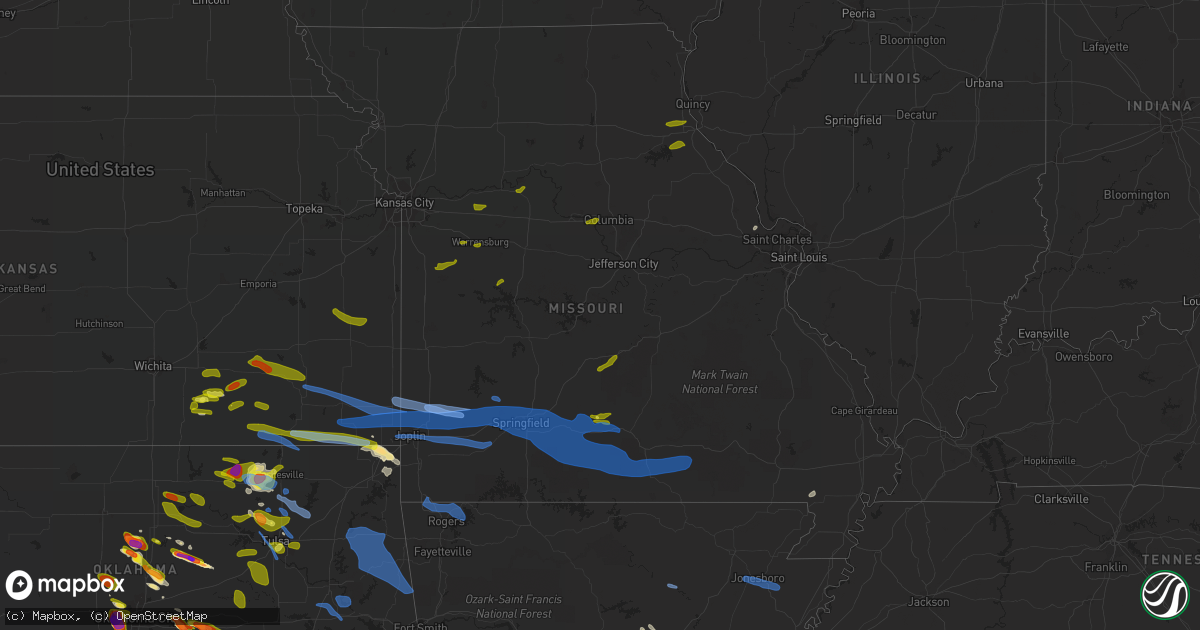
Hail Map in Missouri on April 28, 2020
Get this storm
April 28 map
$229
one time, instant access
Download today. No call, no setup
Keep the $229
Bought the map and want the full workflow? Apply the entire $229 to a subscription within 7 days. None of it is wasted.
Every map, not just this one
This buys you this map. Subscription and you get every map we run, in the markets you choose from a few cities to whole states to nationwide. Plus real-time alerts the moment a storm fires.
Contact data
Name, contact info, occupancy, even credit band for addresses in the footprint. You go from where it hit to who to call.
Become the source they trust
Unlimited branding weather history reports on demand. You already have the documented answer ready for the property owner, and you are the one who showed up with it.
Property data and RoofTrace estimates
Pull up any address you have got, its value and the exact code rules for that jurisdiction, straight from One Click Code. Then RoofTrace estimates the squares, pitch, and roof value, priced the way you price.
Storm reports in Missouri
Missouri
| Date | Description |
|---|---|
| 04/28/20206:59 PM CDT | Corrects previous tstm wnd gst report from 2 wnw ash grove. |
| 04/28/20206:49 PM CDT | Tree into house at high st and mcnatt st. |
| 04/28/20206:47 PM CDT | A local report indicates 1.00 inch wind near WINFIELD |
| 04/28/20206:46 PM CDT | Several trees down in the 3100 block... And a power line down causing a small fire in the miller rural fire area. |
| 04/28/20206:43 PM CDT | 4 inch diameter tree down on power line. |
| 04/28/20206:42 PM CDT | Hwy 39 on dade/lawrence county line. |
| 04/28/20206:26 PM CDT | Delayed report from public of tree damage |
| 04/28/20206:25 PM CDT | Law enforcement reports possible tornado west of sarcoxie on blackberry rd. |
| 04/28/20206:25 PM CDT | A local report indicates 60 MPH wind near 1 NNE JASPER |
| 04/28/20206:21 PM CDT | A local report indicates 75 MPH wind near JASPER |
| 04/28/20206:21 PM CDT | Overturned semi-truck on i-49 at jasper exit. |
| 04/28/20206:19 PM CDT | A local report indicates 70 MPH wind near 2 NNE CARYTOWN |
| 04/28/20206:18 PM CDT | Social media post of golf ball size hail 3 miles northwest of neosho. |
| 04/28/20206:17 PM CDT | Strong thunderstorm wind gusts broke a few power poles near the diamond area. Time estimated from radar. |
| 04/28/20206:10 PM CDT | A local report indicates 62 MPH wind near 1 ENE AIRPORT DRIVE |
| 04/28/20206:08 PM CDT | A section of shingles were blown off of a house near mokane. Via youtube video. |
| 04/28/20206:08 PM CDT | 3.5 in diameter trees down in the area of 13th st and katherine ave. |
| 04/28/20206:07 PM CDT | Multiple trees and power lines down. |
| 04/28/20206:06 PM CDT | Tree down... No injuries. |
| 04/28/20205:14 PM CDT | A local report indicates 1.00 inch wind near 2 SW SANTA FE |
| 04/28/20206:09 AM CDT | At 1109 PM CDT, a severe thunderstorm was located near Marmaduke, moving east at 35 mph. HAZARD...70 mph wind gusts. SOURCE...Radar indicated. IMPACT...Expect considerable tree damage. Damage is likely to mobile homes, roofs, and outbuildings. Locations impacted include... Jonesboro, Paragould, Blytheville, Kennett, Osceola, Piggott, Gosnell, Manila, Lake City, Leachville, Campbell, Rector, Bay, Senath, Brookland, Monette, Caraway, Marmaduke, Chalk Bluff Natural Area and Malden. |
| 04/28/20205:41 AM CDT | At 1041 PM CDT, severe thunderstorms were located along a line extending from near Shook to near Poplar Bluff to near Naylor, moving east at 45 mph. HAZARD...60 mph wind gusts. SOURCE...Radar indicated. IMPACT...Expect damage to roofs, siding, and trees. Locations impacted include... Poplar Bluff, Dexter, Bernie, Bloomfield, Advance, Puxico, Neelyville, Qulin, Fisk, Dudley, Harviell and Rombauer. |
| 04/28/20205:35 AM CDT | At 1035 PM CDT, a severe thunderstorm was located near Evening Star, or 7 miles north of Crowleys Ridge State Park, moving east at 45 mph. HAZARD...60 mph wind gusts. SOURCE...Radar indicated. IMPACT...Expect damage to roofs, siding, and trees. Locations impacted include... Jonesboro, Paragould, Kennett, Piggott, Corning, Bono, Lake City, Leachville, Campbell, Rector, Bay, Senath, Brookland, Monette, Caraway, Marmaduke, Chalk Bluff Natural Area, Crowleys Ridge State Park, Lake Frierson State Park and Malden. |
| 04/28/20205:25 AM CDT | At 1025 PM CDT, severe thunderstorms were located along a line extending from near Marquand to near Cascade to near Greenville, moving east at 55 mph. HAZARD...60 mph wind gusts. SOURCE...Radar indicated. IMPACT...Expect damage to roofs, siding, and trees. Locations impacted include... Marble Hill, Lake Wappapello State Park, Patton, Wappapello, Shook, Alliance, Leopold, Cascade, Grassy, Sedgewickville, Zalma and Glenallen. |
| 04/28/20205:11 AM CDT | At 1011 PM CDT, severe thunderstorms were located along a line extending from near Ellsinore to 7 miles east of Handy to 6 miles northwest of Maynard, moving east at 45 mph. HAZARD...60 mph wind gusts. SOURCE...Radar indicated. IMPACT...Expect damage to roofs, siding, and trees. Locations impacted include... Poplar Bluff, Doniphan, Naylor, Neelyville, Hendrickson, Brush Arbor, Harviell, Budapest, Milltown, Oxly, Fairdealing, Grandin and Briar. |
| 04/28/20204:51 AM CDT | At 951 PM CDT, severe thunderstorms were located along a line extending from near Glover to near Annapolis to Garwood, moving east at 55 mph. HAZARD...60 mph wind gusts. SOURCE...Radar indicated. IMPACT...Expect damage to roofs, siding, and trees. Locations impacted include... Piedmont, Greenville, Sam A. Baker State Park, Williamsville, Lodi, Cascade and Mill Spring. |
| 04/28/20204:42 AM CDT | At 941 PM CDT, severe thunderstorms were located along a line extending from near Bonne Terre to Desloge to near Bismarck to near Iron Mountain to Glover to 6 miles northeast of Garwood, moving east at 50 mph. HAZARD...60 mph wind gusts and penny size hail. SOURCE...Radar indicated. IMPACT...Expect damage to roofs, siding, and trees. Locations impacted include... Farmington, Bonne Terre, Desloge, Fredericktown, Bismarck, Ironton, Leadwood, Park Hills, Ellington, Pilot Knob, Iron Mountain Lake, Arcadia, Irondale, St. Mary, Annapolis, Junction City, Cobalt, Marquand, Knob Lick and Iron Mountain.This includes Interstate 55 in Missouri between exits 141 and 143. This also includes St. Joe State Park, Johnsons Shut-Ins State Park,Hawn State Park, Fort Davidson Historic Site, Elephant Rocks StatePark, Taum Sauk Mountain State Park, Missouri Mines Historic Site,and Clearwater Lake Recreational Area. |
| 04/28/20204:25 AM CDT | At 924 PM CDT, severe thunderstorms were located along a line extending from near Birch Tree to near Alton to near Thayer, moving east at 55 mph. HAZARD...70 mph wind gusts. SOURCE...Radar indicated. IMPACT...Expect considerable tree damage. Damage is likely to mobile homes, roofs, and outbuildings. Locations impacted include... Doniphan, Van Buren, Naylor, Ellsinore, Hunter, Handy, Budapest, Gatewood, Oxly, Fairdealing, Fremont, Grandin and Briar. |
| 04/28/20203:47 AM CDT | At 846 PM CDT, severe thunderstorms were located along a line extending from 8 miles north of Cabool to near Willow Springs to 6 miles northwest of West Plains to near Bakersfield, moving east at 55 mph. HAZARD...70 mph wind gusts. SOURCE...Radar indicated. This line of storms has a history of producing 60 to 70 mph wind gust. IMPACT...Expect considerable tree damage. Damage is likely to mobile homes, roofs, and outbuildings. Locations impacted include... Current River State Park... Echo Bluff State Park... Grand Gulf State Park... Mountain View... Thayer... Winona... Alton... Birch Tree... Eminence... Summersville... Koshkonong... Brandsville... Montier... Thomasville... Lanton... Teresita... Myrtle... Midridge... Rover... Round Spring... |
| 04/28/20203:42 AM CDT | At 841 PM CDT, severe thunderstorms were located along a line extending from near Clark Hill to Crawford to Jasper, moving east at 50 mph. HAZARD...60 mph wind gusts and quarter size hail. SOURCE...Radar indicated. IMPACT...Hail damage to vehicles is expected. Expect wind damage to roofs, siding, and trees. Locations impacted include... Harrison... Mountain Home... Bull Shoals... Yellville... Jasper... Gassville... Flippin... Lakeview in Baxter County... Norfork... Salesville... Bergman... Western Grove... Viola... Lead Hill... Briarcliff... Pyatt... Valley Springs... Arkawana... Dugger... Olvey... |
| 04/28/20203:08 AM CDT | At 808 PM CDT, severe thunderstorms were located along a line extending from 7 miles north of Hartville to near Norwood to 13 miles north of Gainesville to 8 miles north of Price Place, moving east at 50 mph. HAZARD...70 mph wind gusts. SOURCE...Radar indicated. IMPACT...Expect considerable tree damage. Damage is likely to mobile homes, roofs, and outbuildings. Locations impacted include... West Plains... Bull Shoals Lake... Mountain Grove... Licking... Mountain View... Willow Springs... Cabool... Houston... Gainesville... Dawson... Norwood... Pomona... Summersville... Raymondville... Bakersfield... Theodosia... South Fork... Pontiac... Brandsville... Huggins... |
| 04/28/20202:42 AM CDT | At 742 PM CDT, a severe thunderstorm was located over northwestern Fort Leonard Wood, moving east at 25 mph. HAZARD...60 mph wind gusts and half dollar size hail. SOURCE...Radar indicated. IMPACT...Hail damage to vehicles is expected. Expect wind damage to roofs, siding, and trees. Locations impacted include... Rolla... Fort Leonard Wood... Waynesville... St. Robert... Doolittle... Newburg... Edgar Springs... Laquey... Devil's Elbow... Jerome...This includes Interstate 44 between mile markers 144 and 169, andbetween mile markers 171 and 183. |
| 04/28/20202:21 AM CDT | At 720 PM CDT, severe thunderstorms were located along a line extending from near Walnut Grove to Springfield to near Nixa to Reeds Spring, moving east at 60 mph. HAZARD...70 mph wind gusts. SOURCE...Trained weather spotters. 60 to 70 mph wind gusts were reported across Greene CO with this liine of storms. IMPACT...Expect considerable tree damage. Damage is likely to mobile homes, roofs, and outbuildings. Locations impacted include... Marshfield... Mountain Grove... Rogersville... Ava... Seymour... Merriam Woods... Mansfield... Fordland... Dawson... Norwood... Hartville... Niangua... Taneyville... Duncan... Diggins... Wasola... Elkland... Oldfield... Manes... Brixey...This includes Interstate 44 between mile markers 91 and 109. |
| 04/28/20202:01 AM CDT | At 701 PM CDT, severe thunderstorms were located along a line extending from near Hermann to near Gerald to near Owensville, moving east at 45 mph. HAZARD...60 mph wind gusts and penny size hail. SOURCE...Radar indicated. IMPACT...Expect damage to roofs, siding, and trees. Locations impacted include... Washington, Union, Sullivan, St. Clair, Owensville, Hermann, New Haven, Gerald, Marthasville, Innsbrook, Parkway, Rosebud, Miramiguoa Park, Beaufort, Treloar, Dutzow, Berger, Leslie, Noser Mill and Japan.This includes Interstate 44 in Missouri between exits 225 and 242. This also includes Deutschheim Historic Site. |
| 04/28/20201:56 AM CDT | At 655 PM CDT, a severe thunderstorm was located 10 miles east of Lebanon, moving northeast at 25 mph. HAZARD...60 mph wind gusts and half dollar size hail. SOURCE...Radar indicated. IMPACT...Hail damage to vehicles is expected. Expect wind damage to roofs, siding, and trees. Locations impacted include... Northern Fort Leonard Wood... Waynesville... St. Robert... Richland... Stoutland... Laquey... Devil's Elbow... Ozark Springs... Sleeper... Dry Knob...This includes Interstate 44 between mile markers 134 and 166. |
| 04/28/20201:50 AM CDT | At 650 PM CDT, severe thunderstorms were located along a line extending from near Golden City to near Miller to near Mount Vernon to near Purdy, moving east at 50 mph. HAZARD...60 mph wind gusts. SOURCE...Radar indicated. IMPACT...Expect damage to roofs, siding, and trees. Locations impacted include... Springfield... Nixa... Ozark... Republic... Stockton Lake... Table Rock Lake... Monett... Aurora... Battlefield... Willard... Mount Vernon... Rogersville... Strafford... Marionville... Clever... Sparta... Ash Grove... Crane... Fair Grove... Greenfield...This includes Interstate 44 between mile markers 40 and 90. |
| 04/28/20201:46 AM CDT | At 645 PM CDT, severe thunderstorms were located along a line extending from 15 miles northeast of Hermitage to near Macks Creek to near Urbana, moving east at 40 mph. HAZARD...60 mph wind gusts and quarter size hail. SOURCE...Radar indicated. IMPACT...Hail damage to vehicles is expected. Expect wind damage to roofs, siding, and trees. Locations impacted include... Lake of The Ozarks... Lake of The Ozarks State Park... Ha Ha Tonka State Park... Osage Beach... Camdenton... Village of Four Seasons... Lake Ozark... Sunrise Beach... Macks Creek... Linn Creek... Climax Springs... Tunas... Freedom... Hurricane Deck... Old Linn Creek... Branch... Barnumton... Decaturville... Eldridge... Green Bay Terrace... |
| 04/28/20201:24 AM CDT | At 623 PM CDT, severe thunderstorms were located along a line extending from 7 miles north of Chamois to near Linn to Freeburg, moving east at 50 mph. HAZARD...60 mph wind gusts and penny size hail. SOURCE...Radar indicated. IMPACT...Expect damage to roofs, siding, and trees. Locations impacted include... Fulton, Owensville, Hermann, Linn, Belle, Bland, Freeburg, Rosebud, Chamois, Westphalia, Rich Fountain, Swiss, Big Spring, Mount Sterling, Drake, Gasconade, Mokane, Argyle, Rhineland and Morrison.This also includes Deutschheim Historic Site. |
| 04/28/20201:23 AM CDT | At 623 PM CDT, severe thunderstorms were located along a line extending from 7 miles east of Mindenmines to near Jasper to near Carthage to Diamond to near Seneca, moving east at 50 mph. HAZARD...60 mph wind gusts. SOURCE...Radar indicated. IMPACT...Expect damage to roofs, siding, and trees. Locations impacted include... Carthage... Neosho... Stockton Lake... Monett... Aurora... Mount Vernon... Lamar... Marionville... Granby... Greenfield... Sarcoxie... Pierce City... Purdy... Lockwood... Jasper... Diamond... Golden City... Miller... Wheaton... Verona...This includes the following highways... Interstate 44 between mile markers 18 and 58. Interstate 49 between mile markers 36 and 39, and between milemarkers 45 and 65. |
| 04/28/20201:09 AM CDT | At 609 PM CDT, a severe thunderstorm was located near Quapaw, or 7 miles south of Baxter Springs, moving east at 45 mph. HAZARD...60 mph wind gusts. SOURCE...Radar indicated. IMPACT...Expect damage to roofs, siding, and trees. Locations impacted include... Neosho... Seneca... Granby... Fairview... Newtonia... Stella... Stark City... Racine...This includes Interstate 49 between mile markers 15 and 28. |
| 04/28/202012:55 AM CDT | At 554 PM CDT, a severe thunderstorm was located near Warsaw, moving east at 35 mph. HAZARD...60 mph wind gusts and quarter size hail. SOURCE...Radar indicated. IMPACT...Hail damage to vehicles is expected. Expect wind damage to roofs, siding, and trees. Locations impacted include... Lake of The Ozarks... Truman Lake... Warsaw... Laurie... Sunrise Beach... Gravois Mills... Climax Springs... Lakeview Heights... Zora... Fristoe... Knobby... Hurricane Deck... Edwards... Barnumton... Purvis... Hastain... Whitakerville... |
| 04/28/202012:09 AM CDT | At 509 PM CDT, a severe thunderstorm was located near Santa Fe, moving east at 30 mph. HAZARD...60 mph wind gusts and half dollar size hail. SOURCE...Radar indicated. IMPACT...Hail damage to vehicles is expected. Expect wind damage to roofs, siding, and trees. Locations impacted include... Vandalia, Santa Fe, Perry, Laddonia and Farber. |
| 04/27/202011:59 PM CDT | At 458 PM CDT, a severe thunderstorm was located over Midway, moving northeast at 40 mph. HAZARD...60 mph wind gusts and quarter size hail. SOURCE...Radar indicated. IMPACT...Hail damage to vehicles is expected. Expect wind damage to roofs, siding, and trees. Locations impacted include... Columbia, Centralia, Hallsville, Sturgeon, Rocheport, Murry, Midway, Lupus and McBaine.This includes Interstate 70 in Missouri between exits 115 and 133. This also includes Rock Bridge State Park, Finger Lakes State Park,and Jewell Cemetery Historic Site. |
| 04/27/202011:48 PM CDT | At 448 PM CDT, a severe thunderstorm was located near Calhoun, or 10 miles south of Windsor, moving east at 35 mph. HAZARD...60 mph wind gusts and quarter size hail. SOURCE...Radar indicated. IMPACT...Hail damage to vehicles is expected. Expect wind damage to roofs, siding, and trees. Locations impacted include... Truman Lake... Lincoln... Cole Camp... Ionia... Palo Pinto... Mora... Brandon... Crockerville... |
| 04/27/202010:54 PM CDT | At 354 PM CDT, a severe thunderstorm was located near Butler, moving east at 30 mph. HAZARD...60 mph wind gusts and quarter size hail. SOURCE...Radar indicated. IMPACT...Hail damage to vehicles is expected. Expect wind damage to roofs, siding, and trees. Locations impacted include... Butler, Adrian, Urich, Montrose, Passaic and Ballard. |
| 04/27/202010:40 PM CDT | At 339 PM CDT, severe thunderstorms were located along a line extending from near Warrensburg to Archie, moving east at 15 mph. HAZARD...60 mph wind gusts and quarter size hail. SOURCE...Radar indicated. IMPACT...Hail damage to vehicles is expected. Expect wind damage to roofs, siding, and trees. Locations impacted include... Warrensburg, Knob Noster, Holden, Garden City, Whiteman Air Force Base, Creighton, Chilhowee, Whiteman Afb, Centerview, Blairstown and Quick City. |
| 04/27/202010:25 PM CDT | Tree fell on a house. |
| 04/27/202010:13 PM CDT | At 313 PM CDT, a severe thunderstorm was located over Mayview, or near Higginsville, moving east at 40 mph. HAZARD...60 mph wind gusts and quarter size hail. SOURCE...Radar indicated. IMPACT...Hail damage to vehicles is expected. Expect wind damage to roofs, siding, and trees. Locations impacted include... Marshall, Higginsville, Concordia, Waverly, Corder, Alma, Malta Bend, Blackburn, Mayview, Wakenda, Emma, Miami, Dover, Aullville, Mount Leonard and Grand Pass.This includes Interstate 70 in Missouri between mile markers 40 and63. |
| 04/27/202010:12 PM CDT | Delayed report. Tractor trailers moved by wind. Several small trees damaged. Time estimated by radar. |
| 04/27/20209:50 PM CDT | Several trees down and a barn damaged. |
| 04/27/20209:42 PM CDT | Large tree blown over onto rock road just east of bismarck. |
| 04/27/20209:41 PM CDT | Numerous tree limbs blown down as well as several trees on grider road. |
| 04/27/20209:40 PM CDT | Power pole snapped in half on west main street just south of town. |
| 04/27/20209:35 PM CDT | Several barns heavily damaged and a couple of trees down. |
| 04/27/20209:12 PM CDT | Electric co-op reports at least 3 snapped power poles in eminence... Mo. Time estimated from radar. |
| 04/27/20209:07 PM CDT | Several large trees uprooted along highway 19 between round spring and eminence... Mo. Time estimated from radar. |
| 04/27/20209:07 PM CDT | Electric co-op reported a broken power pole in mountain view... Mo. Time estimated from radar. |
| 04/27/20208:50 PM CDT | Recorded at howell county eoc. |
| 04/27/20208:24 PM CDT | A local report indicates 65 MPH wind near MOUNTAIN GROVE |
| 04/27/20208:21 PM CDT | Quarter size hail reported by mountain grove fd... West of town. |
| 04/27/20208:12 PM CDT | Trees down on hwy e. |
| 04/27/20208:07 PM CDT | Trees down on hwy 5. |
| 04/27/20208:06 PM CDT | Minor roof damage to a building near benton park. |
| 04/27/20208:05 PM CDT | 5 trees down facing the same direction across county road 345. |
| 04/27/20208:05 PM CDT | Around a dozen buildings suffered various degrees of roof damage... Along with several trees and tree limbs down. The damage was along a swath from near nebraska ave an |
| 04/27/20208:04 PM CDT | Metal sheeting blown from a roof and tree blown down per local media. Damage occurred near the intersection of cherokee and illinois. Time estimated by radar. |
| 04/27/20208:01 PM CDT | Several trees downed near the douglas and wright county line on hwy b. |
| 04/27/20207:58 PM CDT | Trees down just south of ava off hwy 5. |
| 04/27/20207:55 PM CDT | Trees down across farm road 509 off of hwy k. |
| 04/27/20207:54 PM CDT | Several trees down near the mt. Zion area of douglas co. |
| 04/27/20207:53 PM CDT | Trees down on w hwy 14 and hwy k. |
| 04/27/20207:51 PM CDT | Tree down across hwy a near rome. |
| 04/27/20207:48 PM CDT | Tree and power lines across hwy 76 north of brown branch at dalton rd. |
| 04/27/20207:47 PM CDT | Tree fell into a house. |
| 04/27/20207:45 PM CDT | Several trees downed just south of dogwood. |
| 04/27/20207:45 PM CDT | A couple of small tree limbs down. |
| 04/27/20207:38 PM CDT | Walls blown down on a house that was under construction. Building materials blown all over the place. |
| 04/27/20207:30 PM CDT | Trees down... Metal shed and other outbuildings damaged. |
| 04/27/20207:29 PM CDT | 3 out buildings destroyed... Oak trees about a foot in diameter down. |
| 04/27/20207:17 PM CDT | Large machine shed blown down. Via facebook. |
| 04/27/20207:17 PM CDT | Scattered trees down. |
| 04/27/20207:16 PM CDT | Picture relayed via media partner of a large tree branch snapped off of a tree in springfield... Mo. Time estimated from radar. |
| 04/27/20207:15 PM CDT | Dock and boat damage via central crossing fire. |
| 04/27/20207:13 PM CDT | A local report indicates 60 MPH wind near BATTLEFIELD |
| 04/27/20207:13 PM CDT | Pictures of a few large trees blown over towards the east at a golf course. |
| 04/27/20207:13 PM CDT | Tree down on power line. |
| 04/27/20207:12 PM CDT | Large live tree uprooted. |
| 04/27/20207:11 PM CDT | Numerous trees down; possible tds. |
| 04/27/20207:11 PM CDT | Corrects previous tstm wnd gst report from 4 sse willard from 64 mph to 65 mph. At springfield-branson national airport. |
| 04/27/20207:11 PM CDT | Two large oak trees down. |
| 04/27/20207:10 PM CDT | 50-60 shingles blown off the garage. |
| 04/27/20207:10 PM CDT | Multiple 18 inch tree limbs down. |
| 04/27/20207:08 PM CDT | Large tree limbs down... 5-6 inch in diameter. |
| 04/27/20207:08 PM CDT | A local report indicates 60 MPH wind near BOIS D'ARC |
| 04/27/20207:08 PM CDT | A local report indicates 60 MPH wind near 2 NW WILLARD |
| 04/27/20207:07 PM CDT | A local report indicates 60 MPH wind near 2 WNW ASH GROVE |
| 04/27/20207:07 PM CDT | 5 inch tree down across farm road 87 and farm road 160. |
| 04/27/20207:05 PM CDT | A local report indicates 65 MPH wind near 1 SSW REPUBLIC |
| 04/27/20207:04 PM CDT | Picture relayed via media partner of a large tree broken and toppled over in bois d arc. Time estimated from radar. |
| 04/27/20207:04 PM CDT | 24 inch diameter tree down near farm road 120 and hwy f. |
| 04/27/20207:04 PM CDT | 5 inch diameter limb snapped off of a tree. Time estimated from radar. |
| 04/27/20207:01 PM CDT | 18 inch diameter tree down near farm rd 33 and farm rd 76. |
| 04/27/20207:01 PM CDT | Damage to barn. |
| 04/27/20207:00 PM CDT | Siding and shingle damage... And 10 inch diameter branches down in lawrenceburg. |
All States Impacted by Hail Map on April 28, 2020
Cities Impacted by Hail Map on April 28, 2020
- Windthorst, TX
- Henrietta, TX
- Rison, AR
- Chandler, TX
- Ben Wheeler, TX
- Belcher, LA
- Oil City, LA
- Oklahoma City, OK
- Yukon, OK
- Temple, TX
- Wewoka, OK
- Holdenville, OK
- Sasakwa, OK
- Valley Mills, TX
- China Spring, TX
- Haughton, LA
- Rhome, TX
- Rush Springs, OK
- Marlow, OK
- Lucien, OK
- Covington, OK
- Colleyville, TX
- Southlake, TX
- Bowie, TX
- Jacksboro, TX
- Mcalester, OK
- Hartshorne, OK
- Haileyville, OK
- Wilburton, OK
- Fort Worth, TX
- Amber, OK
- Pocasset, OK
- Minco, OK
- Marshall, TX
- Hallsville, TX
- Elm Mott, TX
- West, TX
- Waco, TX
- Sealy, TX
- Wallis, TX
- Hico, TX
- Gustine, TX
- Carlton, TX
- Dublin, TX
- Stephenville, TX
- Lott, TX
- Nashville, AR
- Dayton, TX
- Eastland, TX
- Cisco, TX
- Albany, TX
- Woodson, TX
- Breckenridge, TX
- Gorman, TX
- Carbon, TX
- Groesbeck, TX
- Killeen, TX
- Harker Heights, TX
- Jefferson, TX
- Troup, TX
- Burleson, TX
- Covington, TX
- Cleburne, TX
- Keene, TX
- Joshua, TX
- Blum, TX
- Godley, TX
- Weatherford, TX
- Grandview, TX
- Aledo, TX
- Rio Vista, TX
- Crowley, TX
- Cresson, TX
- Bethalto, IL
- Moro, IL
- Gatesville, TX
- Wyandotte, OK
- Fairland, OK
- Mamou, LA
- Blanco, OK
- Pittsburg, OK
- Stringtown, OK
- Daisy, OK
- Lewisville, AR
- Stamps, AR
- Hull, TX
- Liberty, TX
- Sperry, OK
- Chillicothe, IL
- Edelstein, IL
- Speer, IL
- Hamilton, TX
- Pottsville, TX
- Comanche, TX
- Evant, TX
- Mullin, TX
- Goldthwaite, TX
- Shawnee, OK
- Mustang, OK
- Wheatland, OK
- Bethany, OK
- Meridian, OK
- Roff, OK
- Tupelo, OK
- Stonewall, OK
- Fitzhugh, OK
- Ada, OK
- Thorndale, TX
- Ashdown, AR
- Mineral Springs, AR
- Dierks, AR
- Lockesburg, AR
- Wilton, AR
- Plain Dealing, LA
- Waxahachie, TX
- Guthrie, OK
- Corsicana, TX
- Wetumka, OK
- Florien, LA
- Thornton, TX
- Franklin, TX
- Kosse, TX
- Omaha, TX
- Proctor, AR
- Heth, AR
- Hughes, AR
- Timpson, TX
- Cameron, TX
- Mexico, MO
- Konawa, OK
- Maud, OK
- Nacogdoches, TX
- Chickasha, OK
- Kiowa, OK
- Greenville, TX
- Quapaw, OK
- North Miami, OK
- Picher, OK
- Commerce, OK
- Miami, OK
- Bryson, TX
- McRae, AR
- Searcy, AR
- Caldwell, TX
- Bellevue, TX
- Fairfield, TX
- Tyler, TX
- Winona, TX
- Overton, TX
- Kilgore, TX
- Taylor, AR
- Diana, TX
- Pineville, LA
- Grand Chenier, LA
- Gueydan, LA
- Rogers, TX
- Burlington, TX
- Buckholts, TX
- Leesville, LA
- Linden, TX
- Tuttle, OK
- Wichita Falls, TX
- Ninnekah, OK
- Zavalla, TX
- Holland, TX
- Little River Academy, TX
- Belton, TX
- Longview, TX
- Karnack, TX
- Harleton, TX
- Ledbetter, TX
- Lincoln, TX
- Giddings, TX
- La Grange, TX
- Cushing, OK
- Ripley, OK
- Mulhall, OK
- Marshall, OK
- Crescent, OK
- Mount Pleasant, TX
- Bogata, TX
- Talco, TX
- Wellston, OK
- Luther, OK
- Coyle, OK
- Pleasant Hill, LA
- Pelican, LA
- Marthaville, LA
- Linn, TX
- Duncan, OK
- Arkadelphia, AR
- Washington, LA
- Palmetto, LA
- Alba, TX
- Mineola, TX
- Mcloud, OK
- Wortham, TX
- Mexia, TX
- Merryville, LA
- Gladewater, TX
- Blanchard, OK
- Newcastle, OK
- Prague, OK
- Meeker, OK
- Earlsboro, OK
- Seminole, OK
- Hooks, TX
- Bluff Dale, TX
- Lecompte, LA
- Cheneyville, LA
- Forest Hill, LA
- Jermyn, TX
- Alvarado, TX
- Orlando, OK
- Fort Hood, TX
- Oglesby, TX
- Benton, LA
- Bruceville, TX
- Moody, TX
- Rockdale, TX
- Decatur, TX
- Cement, OK
- Hillsboro, TX
- Whitney, TX
- Comanche, OK
- Bismarck, AR
- Hemphill, TX
- Midlothian, TX
- Cotton Plant, AR
- Springfield, LA
- Lexington, TX
- Navasota, TX
- Anderson, TX
- Garrison, TX
- Center, TX
- Crockett, TX
- Grapeland, TX
- Marianna, AR
- Moro, AR
- Jacksonville, AR
- Palestine, AR
- Henderson, TX
- Laneville, TX
- Mineral Wells, TX
- Millsap, TX
- Graford, TX
- Pittsburg, TX
- Joaquin, TX
- Tenaha, TX
- Rising Star, TX
- Chireno, TX
- Clarksville, TX
- Van, TX
- Lindale, TX
- Pangburn, AR
- Perkins, OK
- Stillwater, OK
- Star, TX
- Iredell, TX
- Troy, TX
- Crawford, TX
- Meridian, TX
- Rosebud, TX
- Gause, TX
- Cranfills Gap, TX
- Taylor, TX
- Hewitt, TX
- Lorena, TX
- Woodway, TX
- Clifton, TX
- Granger, TX
- Chilton, TX
- Priddy, TX
- Eddy, TX
- Bartlett, TX
- McGregor, TX
- Jonesboro, TX
- Davilla, TX
- Milano, TX
- Devers, TX
- McHenry, MS
- Antlers, OK
- Clayton, OK
- Natchez, LA
- Melrose, LA
- Natchitoches, LA
- Oakwood, TX
- Kerens, TX
- Atlanta, KS
- Rock, KS
- Burden, KS
- Mount Enterprise, TX
- Jacksonville, TX
- Milam, TX
- Trout, LA
- Houston, TX
- Bradley, AR
- Springhill, LA
- Arp, TX
- Grenola, KS
- Letona, AR
- Humnoke, AR
- Stuttgart, AR
- Carlisle, AR
- Woodworth, LA
- Piedmont, OK
- Campbell, MO
- Malden, MO
- Maud, TX
- Richland, TX
- Purdon, TX
- Robeline, LA
- Provencal, LA
- Red Oak, OK
- Pawhuska, OK
- Barnsdall, OK
- Bartlesville, OK
- Clarksdale, MS
- Hartville, MO
- Tatum, TX
- Beckville, TX
- Tolar, TX
- Moline, KS
- Trinidad, TX
- Mabank, TX
- Winnie, TX
- Aquilla, TX
- Church Point, LA
- Itasca, TX
- Granbury, TX
- Zwolle, LA
- Many, LA
- Shreveport, LA
- Sparland, IL
- Haworth, OK
- Dallas, TX
- Wynona, OK
- Arcadia, OK
- Sieper, LA
- Winfield, KS
- Leola, AR
- Saint Francisville, LA
- Angola, LA
- Waurika, OK
- Lumberton, MS
- Dawson, TX
- Frost, TX
- Hubbard, TX
- Azle, TX
- Bynum, TX
- Poolville, TX
- Milford, TX
- Mertens, TX
- Axtell, TX
- Abbott, TX
- Springtown, TX
- Coolidge, TX
- Malone, TX
- Lufkin, TX
- Coushatta, LA
- Batchelor, LA
- Emory, TX
- Tulsa, OK
- Brookshire, TX
- Hempstead, TX
- Arlington, TX
- Round Top, TX
- Caddo Mills, TX
- Bossier City, LA
- Foreman, AR
- Lone Oak, TX
- Point, TX
- Yantis, TX
- Cumby, TX
- Brashear, TX
- Sulphur Springs, TX
- Center, MO
- Monroe City, MO
- Grand Saline, TX
- Hillsboro, IL
- Long Branch, TX
- Bryan, TX
- Barry, TX
- Blooming Grove, TX
- Batson, TX
- Campbell, TX
- Tillatoba, MS
- Scobey, MS
- Carthage, TX
- Iola, TX
- Justin, TX
- Terrell, TX
- Powell, TX
- Graham, TX
- Humble, TX
- East Bernard, TX
- Rose Bud, AR
- Jewett, TX
- Teague, TX
- Donie, TX
- Haslet, TX
- Alvord, TX
- Latham, KS
- Cambridge, KS
- Harrah, OK
- Selman City, TX
- Cooper, TX
- Malakoff, TX
- Eustace, TX
- Detroit, TX
- Rice, TX
- Ennis, TX
- Saratoga, TX
- Heber Springs, AR
- Bunkie, LA
- Winnsboro, TX
- Saltillo, TX
- Mount Vernon, TX
- Cushing, TX
- Chatfield, TX
- Eagle Lake, TX
- Wharton, TX
- Camden, AR
- Flint, TX
- Mansfield, LA
- Hearne, TX
- San Augustine, TX
- Huntington, TX
- Etoile, TX
- Whitehouse, TX
- Thrall, TX
- Converse, LA
- Belmont, LA
- Sunset, LA
- Salado, TX
- Saint Landry, LA
- Ville Platte, LA
- Daingerfield, TX
- Baytown, TX
- Hominy, OK
- Skiatook, OK
- Royse City, TX
- Mooringsport, LA
- Vivian, LA
- Benton, AR
- Sheridan, AR
- Kennedale, TX
- Grand Prairie, TX
- Mansfield, TX
- Cedar Hill, TX
- Haltom City, TX
- Beaumont, TX
- Winthrop, AR
- Scurry, TX
- Rosser, TX
- Tecumseh, OK
- Kemp, TX
- Jarrell, TX
- Fall River, KS
- Eureka, KS
- Fredonia, KS
- Severy, KS
- Forrest City, AR
- Annona, TX
- Hughes Springs, TX
- Marietta, TX
- Boyce, LA
- Lena, LA
- Alligator, MS
- Palestine, TX
- Beebe, AR
- San Saba, TX
- Bagwell, TX
- Perkinston, MS
- Newhope, AR
- Langley, AR
- Kirby, AR
- De Leon, TX
- Rusk, TX
- Carrollton, TX
- Plano, TX
- Lake Arthur, LA
- Wiergate, TX
- Agra, OK
- Allen, OK
- Elkhart, TX
- Neosho, MO
- Gary, TX
- Montgomery, LA
- Harlingen, TX
- Lacon, IL
- Princeville, IL
- Washburn, IL
- Tishomingo, OK
- Magnolia, AR
- Stephens, AR
- Opelousas, LA
- Roanoke, IL
- Lowpoint, IL
- Goodwin, AR
- Cookville, TX
- Bullard, TX
- Livingston, LA
- Walker, LA
- Deville, LA
- Wynne, AR
- Jena, LA
- England, AR
- Pineland, TX
- Glenmora, LA
- Pecan Gap, TX
- Oakdale, LA
- Hosston, LA
- Gilliam, LA
- Cleveland, TX
- O'Fallon, MO
- Naples, TX
- Saint Charles, AR
- De Witt, AR
- Elmer, LA
- Otis, LA
- Chidester, AR
- Sulphur, LA
- Brickeys, AR
- Quitman, TX
- Seneca, MO
- Brookston, TX
- Petty, TX
- Glen Flora, TX
- Natchez, MS
- Donaldson, AR
- Scroggins, TX
- Livingston, TX
- Sumner, TX
- Scott, AR
- Lonoke, AR
- North Little Rock, AR
- Romance, AR
- El Paso, AR
- Brinkley, AR
- Idabel, OK
- Honey Grove, TX
- Edmond, OK
- Hutchins, TX
- Spring, TX
- Gilmer, TX
- Marlin, TX
- Treece, KS
- Baxter Springs, KS
- Verden, OK
- Windom, TX
- Hazen, AR
- Penelope, TX
- Marksville, LA
- Monterey, LA
- Jonesville, LA
- Centrahoma, OK
- Coppell, TX
- Irving, TX
- Quinlan, TX
- Streetman, TX
- Cameron, LA
- Saucier, MS
- Welch, OK
- Avery, TX
- Normangee, TX
- Meredosia, IL
- Bluffs, IL
- Columbus, KS
- Marvell, AR
- Ochelata, OK
- Cascilla, MS
- Fayetteville, TX
- Paige, TX
- Lake Charles, LA
- Hackberry, LA
- Hensley, AR
- Redfield, AR
- Little Rock, AR
- Balch Springs, TX
- Nemo, TX
- Humphrey, AR
- Norwood, MO
- Mountain Grove, MO
- Waskom, TX
- Blossom, TX
- Paris, TX
- Wann, OK
- Tyro, KS
- Niotaze, KS
- Caney, KS
- Copan, OK
- Havana, KS
- Peru, KS
- Sedan, KS
- Chetopa, KS
- Coffeyville, KS
- Independence, KS
- Bartlett, KS
- Liberty, KS
- Edna, KS
- Oronogo, MO
- Sarcoxie, MO
- Drury, MO
- Sparta, MO
- Birch Tree, MO
- Bois D Arc, MO
- Ava, MO
- Purcell, MO
- Miller, MO
- Marshfield, MO
- Pottersville, MO
- Oswego, KS
- Brixey, MO
- West Plains, MO
- Nixa, MO
- Stotts City, MO
- Scammon, KS
- Halltown, MO
- Ash Grove, MO
- Bruner, MO
- Neck City, MO
- Vanzant, MO
- Willow Springs, MO
- Jasper, MO
- McCune, KS
- Pomona, MO
- Altamont, KS
- La Russell, MO
- Webb City, MO
- Zanoni, MO
- Seymour, MO
- Ozark, MO
- Parsons, KS
- Fair Grove, MO
- Wasola, MO
- Willard, MO
- Dora, MO
- Carthage, MO
- Squires, MO
- Carl Junction, MO
- Strafford, MO
- Lockwood, MO
- Pittsburg, KS
- Mansfield, MO
- Brookline, MO
- Alton, MO
- Avilla, MO
- Weir, KS
- Republic, MO
- Asbury, MO
- Everton, MO
- Alba, MO
- Chadwick, MO
- Golden City, MO
- Reeds, MO
- Carterville, MO
- Walnut Grove, MO
- South Greenfield, MO
- Fordland, MO
- Springfield, MO
- Macomb, MO
- Joplin, MO
- Oldfield, MO
- Mount Vernon, MO
- Galena, KS
- Rogersville, MO
- Peace Valley, MO
- West Mineral, KS
- Thayer, KS
- Saint Paul, KS
- Galesburg, KS
- Altoona, KS
- Cherokee, KS
- Mindenmines, MO
- Opolis, KS
- Freistatt, MO
- Verona, MO
- Marionville, MO
- Duenweg, MO
- Monett, MO
- Diamond, MO
- Billings, MO
- Aurora, MO
- Wentworth, MO
- Pierce City, MO
- Mendota, IL
- La Moille, IL
- Sublette, IL
- Minonk, IL
- Benson, IL
- Varna, IL
- Newark, IL
- Needville, TX
- Damon, TX
- Guy, TX
- West Columbia, TX
- Angleton, TX
- Ranger, TX
- Desdemona, TX
- Moran, TX
- Throckmorton, TX
- Scotland, TX
- Perrin, TX
- Loving, TX
- Bridgeport, TX
- Paradise, TX
- Baird, TX
- Palo Pinto, TX
- Ivanhoe, TX
- Hendrix, OK
- Telephone, TX
- Cross Plains, TX
- Lometa, TX
- Somerville, TX
- Nolanville, TX
- Little Elm, TX
- Buffalo, KS
- Toronto, KS
- Benedict, KS
- Leon, KS
- Howard, KS
- Piedmont, KS
- Elk Falls, KS
- Longton, KS
- Welda, KS
- Kincaid, KS
- Blue Mound, KS
- Dearing, KS
- Cedar Vale, KS
- Pineville, MO
- Rogers, AR
- Pea Ridge, AR
- Bentonville, AR
- Garfield, AR
- Noel, MO
- Hiwasse, AR
- Bella Vista, AR
- Huntington, AR
- Greenwood, AR
- Booneville, AR
- Mansfield, AR
- Paris, AR
- Havana, AR
- Magazine, AR
- Danville, AR
- Perryville, AR
- Ola, AR
- Plainview, AR
- Belleville, AR
- Bigelow, AR
- Pottsville, AR
- Houston, AR
- Dardanelle, AR
- Mayflower, AR
- Morrilton, AR
- Atkins, AR
- Conway, AR
- Russellville, AR
- Ulm, AR
- Almyra, AR
- Roe, AR
- Sherwood, AR
- Casscoe, AR
- Crocketts Bluff, AR
- Tucker, AR
- Ozan, AR
- Rosston, AR
- Smackover, AR
- Hope, AR
- Saratoga, AR
- Prescott, AR
- Ogden, AR
- Louann, AR
- Texarkana, AR
- Columbus, AR
- Horatio, AR
- Fulton, AR
- De Queen, AR
- Eagletown, OK
- Washington, AR
- Emmet, AR
- Jonesboro, AR
- Bay, AR
- Lake City, AR
- Batesville, AR
- Van Orin, IL
- Ohio, IL
- Lindsay, TX
- Burneyville, OK
- Pilot Point, TX
- Krum, TX
- Richardson, TX
- Addison, TX
- Era, TX
- Denton, TX
- Muenster, TX
- Sanger, TX
- Gainesville, TX
- Frisco, TX
- Aubrey, TX
- Garland, TX
- The Colony, TX
- Leon, OK
- Valley View, TX
- Keller, TX
- North Richland Hills, TX
- Grapevine, TX
- Rockwall, TX
- Allen, TX
- Lavon, TX
- Rowlett, TX
- Sachse, TX
- Wylie, TX
- Wills Point, TX
- Montalba, TX
- Edgewood, TX
- Forney, TX
- Frankston, TX
- Canton, TX
- Sunnyvale, TX
- Ferris, TX
- Kaufman, TX
- Brownsboro, TX
- Tennessee Colony, TX
- Larue, TX
- Lancaster, TX
- Seagoville, TX
- Murchison, TX
- Athens, TX
- Mesquite, TX
- Wilmer, TX
- Crandall, TX
- Marquez, TX
- Buffalo, TX
- Bivins, TX
- Avinger, TX
- Lone Star, TX
- Atlanta, TX
- Hawkins, TX
- Fruitvale, TX
- Kennard, TX
- Italy, TX
- Newton, TX
- Kirbyville, TX
- Burkeville, TX
- Brookeland, TX
- Jasper, TX
- Bronson, TX
- Shelbyville, TX
- Purmela, TX
- Lampasas, TX
- Copperas Cove, TX
- Kempner, TX
- Danbury, TX
- Santa Fe, TX
- La Porte, TX
- Texas City, TX
- Freeport, TX
- Galveston, TX
- Pasadena, TX
- Kemah, TX
- Seabrook, TX
- Dickinson, TX
- Alvin, TX
- Deer Park, TX
- Liverpool, TX
- Galena Park, TX
- South Houston, TX
- Channelview, TX
- League City, TX
- Hitchcock, TX
- Webster, TX
- Friendswood, TX
- La Marque, TX
- Prosper, TX
- Celina, TX
- Waller, TX
- Magnolia, TX
- New Caney, TX
- Cypress, TX
- Huffman, TX
- Tomball, TX
- Splendora, TX
- Conroe, TX
- Kingwood, TX
- Plantersville, TX
- Montgomery, TX
- Porter, TX
- Bedias, TX
- Shepherd, TX
- Hockley, TX
- Washington, TX
- Richards, TX
- Pinehurst, TX
- Crosby, TX
- Collinsville, OK
- Talala, OK
- Claremore, OK
- Ramona, OK
- Oologah, OK
- Colcord, OK
- Bunch, OK
- Rose, OK
- Welling, OK
- Salina, OK
- Hulbert, OK
- Peggs, OK
- Tahlequah, OK
- Stilwell, OK
- Pryor, OK
- Kansas, OK
- Westville, OK
- Oaks, OK
- Locust Grove, OK
- Natural Dam, AR
- Proctor, OK
- Twin Oaks, OK
- Park Hill, OK
- Sand Springs, OK
- Jenks, OK
- Owasso, OK
- Catoosa, OK
- Checotah, OK
- Oktaha, OK
- Warner, OK
- Braggs, OK
- Muskogee, OK
- Gore, OK
- Gillham, AR
- Sarepta, LA
- Shongaloo, LA
- Dry Creek, LA
- Oberlin, LA
- Mora, LA
- Reeves, LA
- Simpson, LA
- Pitkin, LA
- Elizabeth, LA
- Mittie, LA
- Sugartown, LA
- Longville, LA
- Flatwoods, LA
- Hineston, LA
- Singer, LA
- Ragley, LA
- Cloutierville, LA
- Deridder, LA
- Kinder, LA
- Grant, LA
- Anacoco, LA
- Bell City, LA
- Creole, LA
- Alleene, AR
- Alexander, AR
- Red Rock, OK
- Marland, OK
- Ralston, OK
- Burbank, OK
- Shidler, OK
- Douglas, OK
- Morrison, OK
- Pawnee, OK
- Cashion, OK
- Okarche, OK
- Kingfisher, OK
- Dewey, OK
- Fairfax, OK
- Perry, OK
- Norman, OK
- Mannford, OK
- Sapulpa, OK
- Ringling, OK
- Fletcher, OK
- Loco, OK
- Broken Arrow, OK
- Kellyville, OK
- Mounds, OK
- Beggs, OK
- Castle, OK
- Bristow, OK
- Depew, OK
- Okemah, OK
- Newalla, OK
- Temple, OK
- Hastings, OK
- Nocona, TX
- Ringgold, TX
- Ryan, OK
- Elmore City, OK
- Maysville, OK
- Lindsay, OK
- Pauls Valley, OK
- Sulphur, OK
- Wynnewood, OK
- Davis, OK
- Mayview, MO
- Higginsville, MO
- Holden, MO
- Centerview, MO
- Miami, MO
- Marshall, MO
- Malta Bend, MO
- Creighton, MO
- Garden City, MO
- Warrensburg, MO
- Hannibal, MO
- Palmyra, MO
- Windsor, MO
- Calhoun, MO
- New London, MO
- Wooldridge, MO
- Columbia, MO
- Rocheport, MO
- Lebanon, MO
- Laquey, MO
- Falcon, MO
- Richland, MO
- Waynesville, MO


