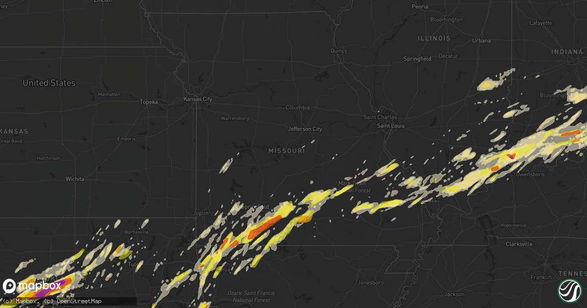
Hail Map in Missouri on April 28, 2017
Get this storm
April 28 map
$229
one time, instant access
Download today. No call, no setup
Keep the $229
Bought the map and want the full workflow? Apply the entire $229 to a subscription within 7 days. None of it is wasted.
Every map, not just this one
This buys you this map. Subscription and you get every map we run, in the markets you choose from a few cities to whole states to nationwide. Plus real-time alerts the moment a storm fires.
Contact data
Name, contact info, occupancy, even credit band for addresses in the footprint. You go from where it hit to who to call.
Become the source they trust
Unlimited branding weather history reports on demand. You already have the documented answer ready for the property owner, and you are the one who showed up with it.
Property data and RoofTrace estimates
Pull up any address you have got, its value and the exact code rules for that jurisdiction, straight from One Click Code. Then RoofTrace estimates the squares, pitch, and roof value, priced the way you price.
Storm reports in Missouri
Missouri
| Date | Description |
|---|---|
| 04/28/20171:30 PM CDT | Between gordonville and jackson |
| 04/28/20173:43 AM CDT | A local report indicates 1.00 inch wind near HARTVILLE |
| 04/28/20173:40 AM CDT | A local report indicates 1.00 inch wind near MANSFIELD |
| 04/28/20173:35 AM CDT | A local report indicates 1.00 inch wind near 5 SSW MANSFIELD |
| 04/28/20173:30 AM CDT | A local report indicates 1.50 inch wind near MANSFIELD |
| 04/28/20173:10 AM CDT | A local report indicates 1.00 inch wind near GOODHOPE |
| 04/28/20172:50 AM CDT | A local report indicates 1.00 inch wind near 1 S HIGHLANDVILLE |
| 04/28/20172:40 AM CDT | A local report indicates 1.00 inch wind near 2 SW WALNUT SHADE |
| 04/28/20172:32 AM CDT | Quarter size hail with some golf ball size hail 1/2 mile west of branson west. |
| 04/28/20172:24 AM CDT | Some hail larger than golf balls. |
| 04/28/20171:37 AM CDT | Quarter hail reported in seligman. |
| 04/28/201712:27 AM CDT | Quarter sized hail reported in vanzant. |
| 04/27/201711:33 PM CDT | Reported via mping. |
| 04/27/201711:23 PM CDT | Quarter sized hail in cassville. |
| 04/27/201711:10 PM CDT | Quarter to golf ball sized hail. |
| 04/27/201710:50 PM CDT | Late report...hail the size of hen eggs report via media. |
All States Impacted by Hail Map on April 28, 2017
Cities Impacted by Hail Map on April 28, 2017
- Stark City, MO
- Fairview, MO
- Grove, OK
- Goodman, MO
- Monett, MO
- Stella, MO
- South West City, MO
- Pierce City, MO
- Jay, OK
- Anderson, MO
- Neosho, MO
- Wentworth, MO
- Sarcoxie, MO
- Stotts City, MO
- Granby, MO
- Bessie, OK
- Weatherford, OK
- Hydro, OK
- Okarche, OK
- Hinton, OK
- Geary, OK
- Corn, OK
- Calumet, OK
- Cordell, OK
- Wheelersburg, OH
- Pedro, OH
- Franklin Furnace, OH
- Waterloo, OH
- Willow Wood, OH
- Ellington, MO
- Olney, IL
- Charleston, IL
- Martinsville, IL
- Westfield, IL
- Lerna, IL
- Toledo, IL
- Greenup, IL
- Marshall, IL
- Casey, IL
- Pawnee, OK
- Fairfax, OK
- Union City, OH
- New Weston, OH
- Rossburg, OH
- Ozark, MO
- Forsyth, MO
- Brownstown, IN
- Vallonia, IN
- Lowell, AR
- Springdale, AR
- Lincoln, AR
- Cave Springs, AR
- Fayetteville, AR
- Bentonville, AR
- Prairie Grove, AR
- Rogers, AR
- Farmington, AR
- Stout, OH
- Chandler, OK
- Georgetown, IN
- Lanesville, IN
- Vanzant, MO
- Mason, WV
- Middleport, OH
- Pomeroy, OH
- Hartford, WV
- Racine, OH
- West Columbia, WV
- Chandler, IN
- Elberfeld, IN
- Evansville, IN
- Haubstadt, IN
- Louisville, KY
- Hale Center, TX
- Littlefield, TX
- Spotswood, NJ
- Monroe Township, NJ
- Helmetta, NJ
- Greenup, KY
- Perryville, MO
- Ava, MO
- Squires, MO
- Bismarck, MO
- Park Hills, MO
- Belleview, MO
- Farmington, MO
- Bloomsdale, MO
- Sainte Genevieve, MO
- Doe Run, MO
- Bonne Terre, MO
- Ironton, MO
- Seligman, MO
- Eureka Springs, AR
- Shell Knob, MO
- Cassville, MO
- Eagle Rock, MO
- La Porte, TX
- Houston, TX
- Pasadena, TX
- Chestnutridge, MO
- Galena, MO
- Kimberling City, MO
- Walnut Shade, MO
- Reeds Spring, MO
- Lampe, MO
- Golden, MO
- Spokane, MO
- Cape Fair, MO
- Branson, MO
- Aurora, MO
- Batavia, OH
- Sparta, IL
- Mcadoo, TX
- Roaring Springs, TX
- Afton, TX
- Dickens, TX
- Spur, TX
- Paducah, TX
- Crosbyton, TX
- Hollis, OK
- Vinson, OK
- Willow, OK
- Mangum, OK
- Marion, IL
- Carbondale, IL
- Hominy, OK
- Cleveland, OK
- Prue, OK
- Barnsdall, OK
- Osage, OK
- Skiatook, OK
- Wynona, OK
- Greensburg, IN
- Westport, IN
- Clarendon, TX
- Cushing, OK
- Yale, OK
- Scottsburg, IN
- Salem, IN
- New Salisbury, IN
- Marysville, IN
- Goshen, KY
- Nabb, IN
- Pekin, IN
- Memphis, IN
- Underwood, IN
- Sellersburg, IN
- Borden, IN
- Otisco, IN
- Lexington, IN
- Madison, IN
- Greenville, IN
- Hanover, IN
- Floyds Knobs, IN
- Charlestown, IN
- Henryville, IN
- Palmyra, IN
- New Albany, IN
- New Washington, IN
- Prospect, KY
- Jeffersonville, IN
- Kingfisher, OK
- Guthrie, OK
- Cashion, OK
- Theodosia, MO
- Plainview, TX
- Kress, TX
- Washburn, MO
- Garfield, AR
- Piedmont, MO
- Winona, MO
- Patterson, MO
- Jasper, IN
- Perry, OK
- Floydada, TX
- Yukon, MO
- Warsaw, KY
- Glencoe, KY
- Sparta, KY
- Dry Ridge, KY
- Ghent, KY
- Verona, KY
- Sanders, KY
- Ozark, IL
- Simpson, IL
- Stonefort, IL
- Dover, KY
- Eldorado, IL
- Harrisburg, IL
- Chadwick, MO
- Rutland, OH
- Cheshire, OH
- Langsville, OH
- Letart, WV
- Bidwell, OH
- Syracuse, OH
- Vinton, OH
- Alpena, AR
- Berryville, AR
- Green Forest, AR
- Panhandle, TX
- Uniontown, KY
- Morganfield, KY
- Waverly, KY
- Macedonia, IL
- Ewing, IL
- Patriot, OH
- Point Pleasant, WV
- Leon, WV
- Gallipolis, OH
- Thurman, OH
- Ramona, OK
- Winslow, IN
- Huntsville, AR
- Wesley, AR
- Ravenswood, WV
- Long Bottom, OH
- Portland, OH
- El Dorado Springs, MO
- Sandborn, IN
- Carlisle, IN
- Linton, IN
- Matador, TX
- Turkey, TX
- Velpen, IN
- Otwell, IN
- Salem, MO
- Licking, MO
- Raymondville, MO
- Jadwin, MO
- Bunker, MO
- Muldrow, OK
- Wilson, TX
- Slaton, TX
- Ralls, TX
- Lorenzo, TX
- Murphysboro, IL
- Coyle, OK
- Perkins, OK
- Duke, MO
- Bruner, MO
- Oldfield, MO
- Sparta, MO
- Morning View, KY
- Independence, KY
- Fort Smith, AR
- Roland, OK
- Arkoma, OK
- Pocola, OK
- Shady Point, OK
- Poteau, OK
- Cameron, OK
- Spiro, OK
- Gould, OK
- Siloam Springs, AR
- Gentry, AR
- Elizabeth, WV
- Tipton, OK
- Van Buren, AR
- Kell, IL
- Salem, IL
- Newton, IL
- Wheeler, IL
- Watonga, OK
- Tahlequah, OK
- Hulbert, OK
- Westville, OK
- Muskogee, OK
- Fort Gibson, OK
- Proctor, OK
- New Harmony, IN
- Carmi, IL
- Morrison, OK
- Glencoe, OK
- Stillwater, OK
- Powersite, MO
- Kirbyville, MO
- Marshfield, MO
- Erick, OK
- Brooksville, KY
- Falmouth, KY
- Broughton, IL
- Petersburg, TX
- Silverton, TX
- Claude, TX
- New Milton, WV
- Salem, WV
- Lockney, TX
- Augusta, KY
- Holton, IN
- Milan, IN
- Nashville, IN
- Guilford, IN
- Lawrenceburg, IN
- Batesville, IN
- Hartsville, IN
- Napoleon, IN
- Osgood, IN
- Elizabethtown, IN
- Freetown, IN
- North Vernon, IN
- Scipio, IN
- Seymour, IN
- Sunman, IN
- West Harrison, IN
- Butlerville, IN
- Columbus, IN
- Grammer, IN
- Waverly, OH
- Jackson, OH
- New Haven, WV
- French Lick, IN
- Taswell, IN
- Wagoner, OK
- Glenallen, MO
- Hennessey, OK
- Campbellsburg, IN
- Tahoka, TX
- Creal Springs, IL
- Maysville, KY
- Ridgedale, MO
- Hollister, MO
- Galatia, IL
- Mount Vernon, IL
- Opdyke, IL
- White Deer, TX
- Lead Hill, AR
- Lubbock, TX
- Newburgh, IN
- Boonville, IN
- Henderson, KY
- Spottsville, KY
- Stilwell, OK
- Bunch, OK
- Oak Ridge, MO
- Frohna, MO
- Altenburg, MO
- Uniontown, MO
- Friedheim, MO
- Old Appleton, MO
- Chester, IL
- Saint Charles, MO
- Tulia, TX
- Paris, IL
- Carter, OK
- Elk City, OK
- Sayre, OK
- Lenapah, OK
- S Coffeyville, OK
- Wann, OK
- Yukon, OK
- Piedmont, OK
- El Reno, OK
- Edmond, OK
- Marshall, OK
- Hutsonville, IL
- Grantsburg, IN
- English, IN
- Groom, TX
- Elizabethtown, IL
- Childress, TX
- Quanah, TX
- Connersville, IN
- Leavenworth, IN
- Hitchcock, OK
- Greenfield, OK
- Herod, IL
- Eddyville, IL
- Carrier Mills, IL
- Tennyson, IN
- Oakland City, IN
- Wadesville, IN
- Huntingburg, IN
- Dale, IN
- Gentryville, IN
- Spurgeon, IN
- Poseyville, IN
- Cynthiana, IN
- Stendal, IN
- Mount Vernon, IN
- Holland, IN
- Lynnville, IN
- Elk Creek, MO
- Norris City, IL
- Lawrenceville, IL
- Oaktown, IN
- Flat Rock, IL
- Seymour, TX
- Steelville, MO
- Potosi, MO
- Mountain View, OK
- Oklahoma City, OK
- Bethany, OK
- Granite, OK
- Sentinel, OK
- Lone Wolf, OK
- Dill City, OK
- Foss, OK
- Blair, OK
- Cannelton, IN
- Leopold, IN
- Mannford, OK
- La Grange, KY
- Jonesboro, IL
- Cape Girardeau, MO
- McClure, IL
- Tamms, IL
- Thebes, IL
- Plato, MO
- Carnegie, OK
- Fort Cobb, OK
- Paoli, IN
- Wister, OK
- Jackson, MO
- Wolf Lake, IL
- Norwood, MO
- Mountain Grove, MO
- Smithfield, KY
- Crestwood, KY
- Middletown, NJ
- Holmdel, NJ
- Red Bank, NJ
- Atlantic Highlands, NJ
- Fair Haven, NJ
- Lincroft, NJ
- Skellytown, TX
- Crescent, OK
- Hartville, MO
- Eminence, KY
- New Castle, KY
- Caledonia, MO
- Belgrade, MO
- Park Hill, OK
- Oologah, OK
- Talala, OK
- Collinsville, OK
- Niangua, MO
- Claremore, OK
- Mansfield, MO
- Browns, IL
- Bellmont, IL
- Allendale, IL
- Decker, IN
- Mount Carmel, IL
- Welling, OK
- Seiling, OK
- Fairview, OK
- Longdale, OK
- Canton, OK
- McLeansboro, IL
- Dahlgren, IL
- Evansville, AR
- Canehill, AR
- Somerset, NJ
- Southside, WV
- Henderson, WV
- Gallipolis Ferry, WV
- Cabool, MO
- Bristow, OK
- Marble Hill, MO
- Greenville, MO
- Seymour, MO
- Berry, KY
- Bois D Arc, MO
- Ash Grove, MO
- Enfield, IL
- Springerton, IL
- Benton, IL
- Harrison, AR
- Hope, IN
- Lumberville, PA
- New Hope, PA
- Manchester, OH
- Ripley, OH
- Otway, OH
- Vanceburg, KY
- West Union, OH
- Blue Creek, OH
- Germantown, KY
- West Portsmouth, OH
- Aberdeen, OH
- Lynx, OH
- Peebles, OH
- Seaman, OH
- Hillsboro, OH
- Brazil, IN
- Mitchell, IN
- Williams, IN
- Shoals, IN
- Ponca City, OK
- Burlington, KY
- Union, KY
- Miller, MO
- Fort Branch, IN
- Robinson, IL
- Bucyrus, MO
- Graff, MO
- Huggins, MO
- Houston, MO
- Solo, MO
- Success, MO
- Amelia, OH
- New Richmond, OH
- Sardinia, OH
- Pryor, OK
- Crown City, OH
- Scottown, OH
- Campbellsburg, KY
- Drury, MO
- Flomot, TX
- Quitaque, TX
- Rocky, OK
- Silva, MO
- Clubb, MO
- Bradleyville, MO
- Burfordville, MO
- Canute, OK
- New Castle, IN
- Belington, WV
- Philippi, WV
- Everton, MO
- Walnut Grove, MO
- Corinth, KY
- Williamstown, KY
- Owenton, KY
- Dover, OK
- Pomona, IL
- Herrin, IL
- Energy, IL
- De Soto, IL
- Makanda, IL
- Cambria, IL
- Alto Pass, IL
- Carterville, IL
- Lucasville, OH
- Piketon, OH
- Saint Francisville, IL
- Vincennes, IN
- Patton, MO
- Fredericktown, MO
- Marquand, MO
- Binger, OK
- Bedford, IN
- Loogootee, IN
- Verona, MO
- Duke, OK
- Meridian, OK
- Arcadia, OK
- Eufaula, OK
- Checotah, OK
- Oktaha, OK
- Warner, OK
- Braggs, OK
- Bristow, IN
- Birdseye, IN
- Mount Alto, WV
- Millwood, WV
- Cottageville, WV
- Ripley, WV
- Republic, MO
- Mount Vernon, MO
- Marionville, MO
- Palestine, WV
- Ferdinand, IN
- Eckerty, IN
- Depauw, IN
- Marengo, IN
- Saint Croix, IN
- Milltown, IN
- Saint Meinrad, IN
- Junction, IL
- New Haven, IL
- Ridgway, IL
- Shawneetown, IL
- Abernathy, TX
- Idalou, TX
- Mount Orab, OH
- Omaha, AR
- Oak Grove, AR
- Kissee Mills, MO
- Blue Eye, MO
- Taneyville, MO
- Campbell Hill, IL
- Ava, IL
- Pinckneyville, IL
- Vienna, IL
- Goreville, IL
- Buncombe, IL
- Hatboro, PA
- Old Bridge, NJ
- Morganville, NJ
- Matawan, NJ
- Golconda, IL
- Orlando, OK
- Covington, OK
- Lucien, OK
- Tulsa, OK
- Noble, IL
- Colony, OK
- Bone Gap, IL
- West Salem, IL
- Pennsboro, WV
- Saint Anthony, IN
- Celestine, IN
- Dubois, IN
- West Plains, MO
- Santa Claus, IN
- Hardinsburg, IN
- Fredericksburg, IN
- Argillite, KY
- Alexandria, KY
- Newport, KY
- Melbourne, KY
- Amarillo, TX
- Heavener, OK
- Hackett, AR
- Bokoshe, OK
- Natural Dam, AR
- Chester, AR
- West Fork, AR
- Ringoes, NJ
- Flemington, NJ
- Hopewell, NJ
- Hillsborough, NJ
- Owasso, OK
- Catoosa, OK
- Jenks, OK
- Dupont, IN
- Versailles, IN
- Shelburn, IN
- Lewis, IN
- Hymera, IN
- Equality, IL
- Sturgis, KY
- New Burnside, IL
- Moores Hill, IN
- Aurora, IN
- Dillsboro, IN
- Georgetown, OH
- Winchester, OH
- Hamersville, OH
- Burbank, OK
- Reedsville, OH
- Coolville, OH
- Hobart, OK
- Altus, OK
- Mulhall, OK
- Olustee, OK
- Gracemont, OK
- Gotebo, OK
- Eldorado, OK
- Crittenden, KY
- De Mossville, KY
- Tamaroa, IL
- Du Quoin, IL
- Wasola, MO
- Rueter, MO
- Noble, MO
- Cedarcreek, MO
- Protem, MO
- Thornfield, MO
- Sperry, OK
- Osceola, MO
- Lowry City, MO
- Waverly, WV
- Walker, WV
- Rushville, IN
- Saint Paul, IN
- Glenwood, IN
- Flat Rock, IN
- Milroy, IN
- Rogersville, MO
- Fordland, MO
- Elizabeth, IN
- Corydon, IN
- New Middletown, IN
- Crane, MO
- Nashville, IL
- Ashley, IL
- Milan, TN
- Drumright, OK
- Robards, KY
- Dewey, OK
- Willow Springs, MO
- Nineveh, IN
- Omaha, IL
- Orleans, IN
- South Greenfield, MO
- Bella Vista, AR
- South Shore, KY
- Dennison, IL
- Vermilion, IL
- Pomona, MO
- Rudy, AR
- Crowell, TX
- Shidler, OK
- Pipersville, PA
- Stockton, NJ
- Point Pleasant, PA
- Carversville, PA
- Doylestown, PA
- Grovespring, MO
- Lamar, IN
- Branchville, IN
- West Baden Springs, IN
- Tell City, IN
- Chrisney, IN
- Olton, TX
- Union City, OK
- Mustang, OK
- Fisherville, KY
- Kansas, IL
- Summers, AR
- Parsons, WV
- Florence, IN
- Patriot, IN
- Willow Hill, IL
- Oblong, IL
- Cisne, IL
- Johnsonville, IL
- West Frankfort, IL
- Sallisaw, OK
- Gans, OK
- Pleasureville, KY
- Princeton, IN
- Isabella, OK
- Okeene, OK
- Ralston, OK
- Latham, OH
- Reeds, MO
- Pawhuska, OK
- Wapakoneta, OH
- McKenzie, TN
- Ramsey, IN
- La Russell, MO
- Crossville, IL
- Griffin, IN
- Grayville, IL
- Marland, OK
- Red Rock, OK
- Tryon, OK
- Agra, OK
- Dundas, IL
- Claremont, IL
- Union City, IN
- Fairdale, KY
- Quincy, KY
- South Portsmouth, KY
- Macomb, MO
- Cuba, MO
- Halltown, MO
- Freeburg, MO
- Argyle, MO
- Koeltztown, MO
- Sedgewickville, MO
- Lamar, MO
- Lookeba, OK
- Morrisville, PA
- Witter, AR
- Odell, TX
- Chillicothe, TX
- Vernon, TX
- Corydon, KY
- Roosevelt, OK
- Coweta, OK
- Jones, OK
- Buckhannon, WV
- Walnut Hill, IL
- Saint Mary, MO
- Medora, IN
- Tunnelton, IN
- Sand Springs, OK
- Norman, IN
- Bloomington, IN
- Unionville, IN
- Trafalgar, IN
- Morgantown, IN
- Clinton, OK
- Milton, KY
- Carrollton, KY
- Vevay, IN
- Rising Sun, IN
- Scheller, IL
- Lakeview, TX
- Morrow, AR
- Anna, IL
- Evanston, IN
- Francisco, IN
- Dongola, IL
- Lincoln City, IN
- Richland, IN
- Schnellville, IN
- Rosiclare, IL
- Exeter, MO
- Thomas, OK
- Custer City, OK
- Arapaho, OK
- Seabrook, TX
- Deer Park, TX
- Turners Station, KY
- Bethlehem, KY
- Perry Park, KY
- Lockport, KY
- Mill Spring, MO
- Mcalester, OK
- Bluford, IL
- Sims, IL
- Keenes, IL
- Battletown, KY
- Payneville, KY
- Wyandotte, OK
- Wellston, OK
- Highlandville, MO
- Beaver, OH
- Cadet, MO
- Princeton, NJ
- Sedan, KS
- Peru, KS
- Ames, OK
- Westport, KY
- Strafford, MO
- Hiwasse, AR
- Powell, MO
- Brookline, MO
- Watts, OK
- Nixa, MO
- Gravette, AR
- Rocky Comfort, MO
- Noel, MO
- Pea Ridge, AR
- Pineville, MO
- Hindsville, AR
- Decatur, AR
- Billings, MO
- Clever, MO
- Sulphur Springs, AR
- Centerton, AR
- Ponce De Leon, MO
- Colcord, OK
- Springfield, MO
- Rockaway Beach, MO
- Garrison, MO
- Meadow, TX
- Owensville, IN
- Clinton, IN
- New Goshen, IN
- West Terre Haute, IN
- Universal, IN
- Minco, OK
- Purdy, MO
- Gipsy, MO
- Whitewater, MO
- Van Buren, MO
- Lodi, MO
- Lowndes, MO
- Leopold, MO
- Vulcan, MO
- Puxico, MO
- Friendship, OH
- Williamsburg, OH
- Bethel, OH
- Sweetwater, OK
- Cheyenne, OK
- Stroud, OK
- Edwardsport, IN
- Lyons, IN
- Bicknell, IN
- Bruceville, IN
- Freelandville, IN
- Omega, OK
- Maramec, OK
- Loyal, OK
- Ripley, OK
- Anadarko, OK
- Luther, OK
- Merom, IN
- Sullivan, IN
- Palestine, IL
- Sulphur, KY
- Athens, OH
- Albany, OH
- Billings, OK
- Johnston City, IL
- Saint James, MO
- Birch Tree, MO
- Glenview, KY
- Harrison, OH
- Davisville, MO
- Boss, MO
- Viburnum, MO
- Bixby, MO
- Farmersville, OH
- Germantown, OH
- Liberty, IN
- Brownsville, IN
- Mount Olivet, KY
- Worthville, KY
- Pendleton, KY
- Cynthiana, KY
- New Liberty, KY
- Compton, AR
- Winslow, AR
- Ottsville, PA
- Lambertville, NJ
- Perkasie, PA
- Black, MO
- Eunice, MO
- Yellville, AR
- Summersville, MO
- Hartshorn, MO
- Peel, AR
- Isabella, MO
- Chouteau, OK
- Inola, OK
- Rockport, WV
- Eminence, MO
- Ellis Grove, IL
- Modoc, IL
- Annapolis, MO
- Cleves, OH
- Clifford, IN
- Heltonville, IN
- Delaware, OK
- Depew, OK
- Petersburg, KY
- Williamstown, WV
- Eucha, OK
- Salina, OK
- Reed, KY
- Rarden, OH
- Dora, MO
- Belle Rive, IL
- Thompsonville, IL
- Vienna, WV
- Parkersburg, WV
- Chaffee, MO
- Ropesville, TX
- Mayslick, KY
- Tollesboro, KY
- Portsmouth, OH
- Broken Arrow, OK
- Kingston, AR
- Centerpoint, IN
- Poland, IN
- Reelsville, IN
- Cypress, IL
- Troy, IN
- Daisy, MO
- Crandall, IN
- Derby, IN
- Clarksville, IN
- Bedford, KY
- Garrison, KY
- Russellville, OH
- Buckner, KY
- Austin, IN
- Cobden, IL
- Advance, MO
- Sadieville, KY
- Owensboro, KY
- Grand Tower, IL
- Farrar, MO
- Butler, KY
- Cave In Rock, IL
- Millersville, MO
- Jacob, IL
- Foster, KY
- Sulphur, IN
- Meta, MO
- Saint Elizabeth, MO
- Le Roy, WV
- Cincinnati, OH
- Brookville, IN
- Miamitown, OH


