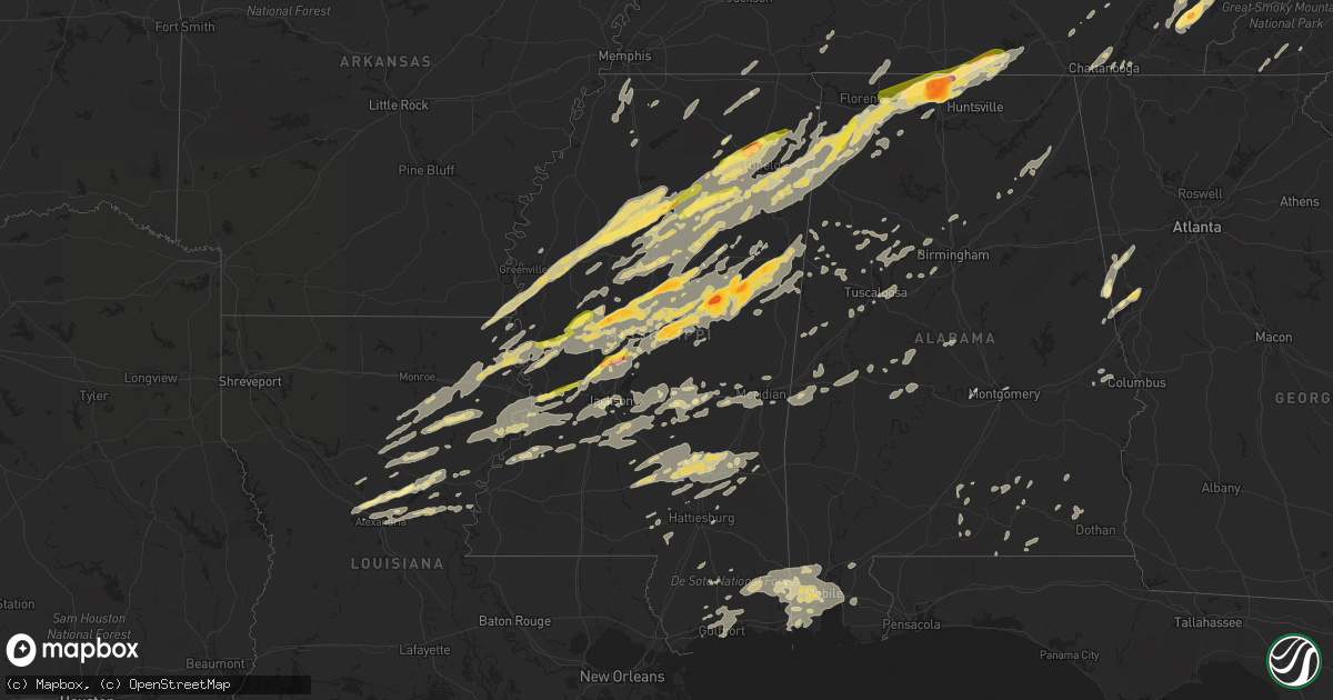
Hail Map in Mississippi on April 28, 2014
Get this storm
April 28 map
$229
one time, instant access
Download today. No call, no setup
Keep the $229
Bought the map and want the full workflow? Apply the entire $229 to a subscription within 7 days. None of it is wasted.
Every map, not just this one
This buys you this map. Subscription and you get every map we run, in the markets you choose from a few cities to whole states to nationwide. Plus real-time alerts the moment a storm fires.
Contact data
Name, contact info, occupancy, even credit band for addresses in the footprint. You go from where it hit to who to call.
Become the source they trust
Unlimited branding weather history reports on demand. You already have the documented answer ready for the property owner, and you are the one who showed up with it.
Property data and RoofTrace estimates
Pull up any address you have got, its value and the exact code rules for that jurisdiction, straight from One Click Code. Then RoofTrace estimates the squares, pitch, and roof value, priced the way you price.
Storm reports in Mississippi
Mississippi
| Date | Description |
|---|---|
| 04/28/20146:55 PM CDT | Tornado on the ground at new hope and highway 182 |
| 04/28/20146:49 PM CDT | Major damage in richland. Reported by spotter. |
| 04/28/20146:48 PM CDT | Powerlines down on howsan circle |
| 04/28/20146:47 PM CDT | Multiple 12 inch trees down at shiloh park in brandon |
| 04/28/20146:45 PM CDT | Developing tornado near ms highway 69 and ms highway 182 |
| 04/28/20146:45 PM CDT | Trees downed on old fannin road |
| 04/28/20146:43 PM CDT | Structural damage on metro parkway |
| 04/28/20146:43 PM CDT | Roof damage to bob boyte honda. Trees down at college street and prescott |
| 04/28/20146:43 PM CDT | Several trailers destroyed or damaged in highlands mobile home park. Reported by highway patrol. |
| 04/28/20146:41 PM CDT | Powerlines down near 1-20 and airport road near tokins drive. Truck across the road. |
| 04/28/20146:40 PM CDT | Shed damaged at mid-south auction |
| 04/28/20146:40 PM CDT | This tornado destroyed two mobile homes near the alabama state line. It also knocked down numerous trees...some of which fell onto homes and outbuildings. Est max winds |
| 04/28/20146:40 PM CDT | A couple trees down |
| 04/28/20146:40 PM CDT | Trees down on old whitfield and airport road |
| 04/28/20146:38 PM CDT | This tornado destroyed two mobile homes near the alabama state line. It also knocked down numerous trees...some of which fell onto homes and outbuildings. Est max winds |
| 04/28/20146:35 PM CDT | Tornado on the ground near intersection of highway 45 and highway 82. Reported by spotter. |
| 04/28/20146:33 PM CDT | Major damage in richland. Reported by spotter. |
| 04/28/20146:32 PM CDT | Tanker in ditch and major structural damage near highway 49 and old 49 intersection. |
| 04/28/20146:31 PM CDT | *** 1 fatal *** approximate start of tornado track in rankin county. Preliminary evaluation of damage in richland/pearl area indicates ef3 damage. Damage survey will be |
| 04/28/20146:27 PM CDT | *** 1 fatal *** approximate start of tornado track in rankin county. Preliminary evaluation of damage in richland/pearl area indicates ef3 damage. Damage survey will be |
| 04/28/20146:25 PM CDT | Reported on tv road |
| 04/28/20146:25 PM CDT | *** 1 inj *** 3 mobile homes damaged by downed trees along hickory drive. |
| 04/28/20146:25 PM CDT | Multiple highway signs knocked down along i-55 near mile-marker 118. |
| 04/28/20146:25 PM CDT | Tree fell on a house on flowers drive. Reported by amateur radio operator. |
| 04/28/20146:22 PM CDT | Trees down on tilman rd and around pattison...possible tornado. |
| 04/28/20146:22 PM CDT | A couple trees were uprooted along ms highway 18 |
| 04/28/20146:20 PM CDT | Multiple trees and power poles snapped. |
| 04/28/20146:20 PM CDT | Many trees and power lines down |
| 04/28/20146:18 PM CDT | This ef1 tornado caused damage to a speedway and the roofs of several houses. Numerous trees were downed. Maximum winds were 105 mph...maximum width was 100 yards and t |
| 04/28/20146:15 PM CDT | Trees down along highway 82 just east of highway 12. Winds estimated about 75-80 mph. Reported by spotter. |
| 04/28/20146:15 PM CDT | This tornado snapped and uprooted numerous trees along its path. Some trees caused damage to some homes roofs and some outbuildings were also damaged. Est max winds 105 |
| 04/28/20146:14 PM CDT | Highway 27 closed due to several large trees down between big black and warrior trail |
| 04/28/20146:14 PM CDT | Gluckstadt fire department responding to damage around lake caroline |
| 04/28/20146:14 PM CDT | Springfield mb church on highway 45 destroyed. Powerlines were also down. |
| 04/28/20146:13 PM CDT | This tornado knocked down two trees and other large branches in a residential area on the west side of canton. Glass in windows and doors was broken and shingle damage |
| 04/28/20146:10 PM CDT | Tornado on the ground near intersection of highway 45 and highway 82. Reported by spotter. |
| 04/28/20146:10 PM CDT | Multiple highway signs knocked down along i-55 near mile-marker 118. |
| 04/28/20146:08 PM CDT | This tornado snapped and uprooted numerous trees along its path. Some trees caused damage to some homes roofs and some outbuildings were also damaged. Est max winds 105 |
| 04/28/20146:05 PM CDT | Trees and power lines downed and roof damage to some homes in the lake caroline area |
| 04/28/20146:04 PM CDT | Highway 27 closed due to several large trees down between big black and warrior trail |
| 04/28/20146:03 PM CDT | Many trees and power lines down |
| 04/28/20146:02 PM CDT | Multiple trees and power poles snapped. |
| 04/28/20146:00 PM CDT | Started just southwest of chapel lane...crossed over mansdale road and then stribling road before ending just after crossing caroline boulevard. Path length 3.75 miles. |
| 04/28/20145:58 PM CDT | Springfield mb church on highway 45 destroyed. Powerlines were also down. |
| 04/28/20145:57 PM CDT | Trees down in and around thomastown and along the trace. |
| 04/28/20145:53 PM CDT | This tornado destroyed a church along highway 45 and caused significant damage to a well constructed barn and to several homes. Several power poles and hundreds of tree |
| 04/28/20145:50 PM CDT | Tornado confirmed in pocohantas by emergency management |
| 04/28/20145:50 PM CDT | Radar debris signature just outside utica. |
| 04/28/20145:50 PM CDT | 18 wheeler over-turned on highway 45 alternate |
| 04/28/20145:48 PM CDT | Tornado touched down along thornton road and tracked north of utica across ms highway 27 and tom collins rd. It continued ene near the adams and lebanon communities cro |
| 04/28/20145:41 PM CDT | This tornado had a very short track. It damaged the roof of a mobile home and knocked down trees in crawford. |
| 04/28/20145:40 PM CDT | 18 wheeler over-turned on highway 45 alternate |
| 04/28/20145:40 PM CDT | Trees down on whitaker rd |
| 04/28/20145:39 PM CDT | This tornado had a very short track. It damaged the roof of a mobile home and knocked down trees in crawford. Est max winds 90 mph. Path length 0.67 miles. Est max widt |
| 04/28/20145:38 PM CDT | This tornado had a very short track. It damaged the roof of a mobile home and knocked down trees in crawford. |
| 04/28/20145:38 PM CDT | A local report indicates 1.75 inch wind near ARTESIA |
| 04/28/20145:37 PM CDT | Several trees across rds... Old port gibson... Midway and curtis luster. |
| 04/28/20145:30 PM CDT | A local report indicates 1.75 inch wind near 6 WNW CRAWFORD |
| 04/28/20145:30 PM CDT | Em reports trees and power lines downed along with dime size hail. Additional report of tops torn off trees in this area that also extends back sw toward bluff lake...l |
| 04/28/20145:27 PM CDT | Trees down across shilo and ashland rds |
| 04/28/20145:23 PM CDT | Trees down near bluff lake |
| 04/28/20145:20 PM CDT | This tornado touched down in the noxubee wildlife refuge and traveled ne into se oktibbeha county...uprooting trees along skinner rd before it lifted. Est max wind 85 m |
| 04/28/20145:20 PM CDT | Started along goat hill road...paralleled highway 22 for a short period...crossed queen hill road and ended just after crossing mcguffee rd. Most intense tree damage wa |
| 04/28/20145:17 PM CDT | Tornado confirmed by emergency manager a few miles southeast of vicksburg. |
| 04/28/20145:15 PM CDT | Several vehicles damaged along the bluff lake rd area. |
| 04/28/20145:14 PM CDT | This tornado touched down in the noxubee wildlife refuge and traveled ne into se oktibbeha county...uprooting trees along skinner rd before it lifted. Est max wind 105 |
| 04/28/20145:04 PM CDT | Reported at ms highway 12 and cr 4101 |
| 04/28/20145:04 PM CDT | Highway 27 closed due to several large trees down between big black and warrior trail |
| 04/28/20145:04 PM CDT | Tornado confirmed by emergency manager a few miles southeast of vicksburg. Several homes damaged by trees. Several roads closed in the area. |
| 04/28/20144:55 PM CDT | *** 1 inj *** started just west of fisher ferry road...paralleled gibson road and ended just east of hwy 27. Path length 4.75 miles. Max path width 200 yards. Estimated |
| 04/28/20144:55 PM CDT | Second tornado reported by storm chasers on the sw side of louisville |
| 04/28/20144:44 PM CDT | Damaged window screens on the house. |
| 04/28/20144:44 PM CDT | A swath of large damaging hail fell across most of winston co...mainly along the hwy 14 corridor in the west half and then through the bluff lake rd corridor. Many vehi |
| 04/28/20144:38 PM CDT | Several sources are reporting considerable damage around louisville |
| 04/28/20144:36 PM CDT | *** 7 fatal *** several sources are reporting considerable damage around louisville...officials report 7 fatalities have been confirmed. People are still missing at thi |
| 04/28/20144:35 PM CDT | Winston county medical center has 2 walls down and a third wall damaged. Also has a gas leak. |
| 04/28/20144:34 PM CDT | Mhp starkville reports heavy damage on the south side of louisville around the country club |
| 04/28/20144:30 PM CDT | Storm chaser reports the tornado is over a mile wide |
| 04/28/20144:20 PM CDT | Msu chasers report 1/2 mile wide tornado. Home damage and large tree damage. |
| 04/28/20144:15 PM CDT | Power out on highway 463 near madison high school. Roads closed and multiple homes damaged. A few injuries. |
| 04/28/20144:13 PM CDT | Tornado approximately 1/4 mile wide |
| 04/28/20144:10 PM CDT | Tornado on ground. |
| 04/28/20144:09 PM CDT | Considerable damage along the ms highway 25 corridor in sw winston county |
| 04/28/20144:04 PM CDT | Storm chasers report large multi vortex tornado has crossed ms highway 19 in sw winston county |
| 04/28/20144:02 PM CDT | Trees downed and a mobile home was damaged. |
| 04/28/20144:02 PM CDT | Trees downed and a shed blown away in far se attala county. |
| 04/28/20143:53 PM CDT | Tornado reported just north of renfroe. Tree lofted into the air |
| 04/28/20143:53 PM CDT | Tornado reported just north of renfroe. Tree lofted into the air |
| 04/28/20143:51 PM CDT | *** 9 fatal *** this tornado began across northern leake county moved through extreme southeast attala county and then was mainly in winston county. The tornado was rat |
| 04/28/20143:51 PM CDT | *** 10 fatal *** this tornado began across northern leake county moved through extreme southeast attala county and then was mainly in winston county. The tornado was ra |
| 04/28/20143:35 PM CDT | A local report indicates 1.75 inch wind near THOMASTOWN |
| 04/28/20143:35 PM CDT | Barn roof damaged |
| 04/28/20143:25 PM CDT | Reported 4 miles east of the carmack community |
| 04/28/20143:21 PM CDT | Spotter reports of a tornado near lodi. |
| 04/28/20143:21 PM CDT | Spotter reports of a tornado near lodi. |
| 04/28/20143:20 PM CDT | In the carmack community |
| 04/28/20143:00 PM CDT | A local report indicates 1.00 inch wind near TUPELO |
| 04/28/20142:55 PM CDT | Some homes damaged along herring school road between highway 407 and kilmichael. Report relayed via social media. Possible tornado. |
| 04/28/20142:51 PM CDT | This ef1 tornado damaged roofs of several homes and knocked down numerous trees. One mobile home was destroyed and another was damaged. Maximum path width was 100 yards |
| 04/28/20142:50 PM CDT | Tornado at intersection of hwy 45 and hwy 78. |
| 04/28/20142:47 PM CDT | 1 mile south of hwy 78 close to natchez trace state park |
| 04/28/20142:45 PM CDT | Trees down on hwy 17s. |
| 04/28/20142:40 PM CDT | Reported just west of town |
| 04/28/20142:32 PM CDT | Report of ping pong ball size hail northwest of canton on patrick road. |
| 04/28/20142:30 PM CDT | Windows broken out of a house on johnson rd |
| 04/28/20142:27 PM CDT | A local report indicates 1.25 inch wind near 1 S CALHOUN CITY |
| 04/28/20142:20 PM CDT | A local report indicates 1.00 inch wind near 2 W BLACK HAWK |
| 04/28/20142:20 PM CDT | A local report indicates 1.00 inch wind near PITTSBORO |
| 04/28/20142:15 PM CDT | Nickel to quarter sized hail falling in flora. |
| 04/28/20142:08 PM CDT | Report of tornado on the ground. |
| 04/28/20142:05 PM CDT | Trees down hwy 12 south of tchula. |
| 04/28/20141:57 PM CDT | Several storm chasers witnessed a brief tornado touchdown in an open field northwest of the intersection of state highways 3 and 433. No damage appears to have occurred |
| 04/28/20141:56 PM CDT | Large tree was down on a camper along girl scout rd. |
| 04/28/20141:56 PM CDT | A local report indicates 1.00 inch wind near 6 E GRENADA |
| 04/28/20141:24 PM CDT | Few trees down in city |
| 04/28/20141:20 PM CDT | Reported at the airport... Roof damage occurred from the hail. |
| 04/28/20141:06 PM CDT | Few trees down around holcomb and west side of the county. |
| 04/28/20141:04 PM CDT | A local report indicates 1.00 inch wind near HOLCOMB |
| 04/28/201412:56 PM CDT | Dime size with a few quarter size |
| 04/28/201412:51 PM CDT | Dime to quarter size hail on highway 532 |
| 04/28/20147:15 AM CDT | Reports of possible tree damage...siding off of structure |
| 04/28/20147:00 AM CDT | Large tree limbs down on power lines. Several power outages. |
| 04/28/20147:00 AM CDT | Tree down on austin road. |
| 04/28/201412:23 AM CDT | Tree down on a house |
| 04/27/201411:14 PM CDT | A few trees down |
| 04/27/201411:00 PM CDT | *** 6 inj *** reports of at least 10 homes damaged across wayne county...mainly from the northwest portion of the county to the southeast. |
| 04/27/201410:30 PM CDT | *** 4 inj *** vehicle with four passengers struck a downed tree lying across highway 45 south. |
| 04/27/201410:26 PM CDT | Cr 173 hose on fire. Cr 19 trees were down and there were several power outages around stringer. Reported by emergency manager. |
| 04/27/201410:26 PM CDT | Trees down on cr 35 north of cr 333 near heildelberg.tree on a house off of highway11. Reported by emergency management. |
| 04/27/201410:15 PM CDT | 18 wheeler over-turned at intersection of highways 45 and 84. |
| 04/27/201410:15 PM CDT | Power outages across sandersville. Numerous trees down on roads including lindsey... Highway 11n... 29th at audubon and dallas brownlee. Mobile home damaged on sherman road ( |
| 04/27/201410:00 PM CDT | A few trees down |
| 04/27/20149:58 PM CDT | Tree fell on a car trapping one person. Injuries unkknown. Reported by emergency management. |
| 04/27/20149:57 PM CDT | Few trees down |
| 04/27/20149:50 PM CDT | Trees were downed on dallas brownlee road |
| 04/27/20149:45 PM CDT | Trees down on cr 35 north of cr 333 near heidelberg. Tree on a house off of us 11. |
| 04/27/20149:45 PM CDT | Power outages across sandersville. Numerous trees down on roads including lindsey and highway 11n. |
| 04/27/20149:43 PM CDT | Mobile home damaged on sherman road |
| 04/27/20149:40 PM CDT | *** 15 inj *** tornado began just east of i-59 between laurel and sandersville...moving e across us 11 then just south of sandersville. Several homes were damaged along |
| 04/27/20149:35 PM CDT | Trees and power lines down |
| 04/27/20149:25 PM CDT | A local report indicates 1.00 inch wind near SOSO |
| 04/27/20149:25 PM CDT | Multiple trees and power lines down |
| 04/27/20149:20 PM CDT | Numerous trees down in meridian |
| 04/27/20149:20 PM CDT | Cr 173 house on fire. Cr 19 trees were down and there were several power outages around stringer. |
| 04/27/20149:20 PM CDT | A few trees down |
| 04/27/20149:15 PM CDT | A few trees down on the e side of the county |
| 04/27/20149:08 PM CDT | Trees and power lines down around hot coffee. |
| 04/27/20149:05 PM CDT | Trees down |
| 04/27/20149:00 PM CDT | Power out on new zion road off highway 27 near crystal springs. |
| 04/27/20148:55 PM CDT | Trees blown down just north of meridian |
| 04/27/20148:55 PM CDT | Numerous trees down in meridian |
| 04/27/20148:50 PM CDT | Trees and power lines down around mize |
| 04/27/20148:50 PM CDT | Trees blown down in the bailey area |
| 04/27/20148:48 PM CDT | Numerous trees and powerlines snapped on allen swamp road just west of okatibbee creek. Possible tornado. |
| 04/27/20148:45 PM CDT | Numerous trees blown down |
| 04/27/20148:45 PM CDT | Several trees blown down |
| 04/27/20148:45 PM CDT | Numerous trees blown down |
| 04/27/20148:35 PM CDT | Large tree branches down with one through the roof of a house. |
| 04/27/20148:35 PM CDT | Tornado touched down near the intersection of chunky-duffee rd and wells rd in eastern newton co...continuing eastward into lauderdale co. Tornado continued through the |
| 04/27/20148:30 PM CDT | Numerous trees and sct power lines were down... Part of a roof pealed off a mobile home... A house on blocks was shifted off the foundation. Minor roof damage was noted to (j |
| 04/27/20148:30 PM CDT | Power pole down |
| 04/27/20148:27 PM CDT | Trees and power lines down across the n and ne part of the county |
| 04/27/20148:15 PM CDT | Trees and power lines downed along country club rd. Likely tornado |
| 04/27/20148:12 PM CDT | Tornado developed south of decatur just south of first newton county tornado track. Several homes sustained significant roof damage near the decatur country club and th |
| 04/27/20148:10 PM CDT | Trees down |
| 04/27/20148:05 PM CDT | About 20 homes damaged across central newton county from near conehatta to near decatur along braddick rd to newton-conehatta rd to highway 503 to chapel hill road. |
| 04/27/20148:05 PM CDT | About 20 homes damaged across central newton county from near conehatta to near decatur along braddick rd to newton-conehatta rd to highway 503 to chapel hill road. |
| 04/27/20147:58 PM CDT | Tornado touched down ne of lake and moved to just south of decatur. Damage was primarily limited to tree damage. Some houses sustained roof damage and one chicken house |
| 04/27/20147:57 PM CDT | Trees down and power outages on dee williams and line prairie road near highway 481. |
| 04/27/20147:52 PM CDT | Tornado touched down ne of lake and moved to just south of decatur. Damage was primarily limited to tree damage. Some houses sustained roof damage and one chicken house |
| 04/27/20147:44 PM CDT | Sct trees down |
| 04/27/20147:43 PM CDT | Multiple 12 inch trees down at shiloh park in brandon |
| 04/27/20147:38 PM CDT | *** 3 inj *** tornado developed just east of forest and quickly intensified along old hwy 80. A wood frame home was nearly destroyed. A chicken house was completely des |
| 04/27/20147:36 PM CDT | *** 3 inj *** tornado developed just east of forest and quickly intensified along old hwy 80. A wood frame home was nearly destroyed. A chicken house was completely des |
| 04/27/20147:35 PM CDT | Several trees were down and a roof was torn off a cabin...this occurred at the neshoba co fairgrounds. |
| 04/27/20147:33 PM CDT | A local report indicates 1.00 inch wind near 4 W BRAXTON |
| 04/27/20147:33 PM CDT | Structural damage on metro parkway |
| 04/27/20147:33 PM CDT | Sct trees down |
| 04/27/20147:30 PM CDT | Possible tornado...one home and a chicken house destroyed at 1887 old highway 80. |
| 04/27/20147:29 PM CDT | Trees on railroad tracks at highway 18 near greenfield road. |
| 04/27/20147:29 PM CDT | Possible tornado...roof damage to hospital in forest |
| 04/27/20147:15 PM CDT | Trees down and power outages on dee williams and line prairie road near highway 481. |
| 04/27/20147:15 PM CDT | Power out on new zion road off highway 27 near crystal springs. |
| 04/27/20147:14 PM CDT | Radar debris signature noted 2 ene of standing pine. |
| 04/27/20147:10 PM CDT | Shed damaged at mid-south auction |
| 04/27/20147:09 PM CDT | Trees down on old whitfield and airport road |
| 04/27/20147:09 PM CDT | Many homes damaged. Numerous trees down on shiloh... Pleasant... St louis... Wilson and gayden roads. |
| 04/27/20147:08 PM CDT | Tree fell on a house on flowers drive. Reported by amateur radio operator. |
| 04/27/20147:08 PM CDT | This ef1 tornado destroyed a chicken house and damaged 3 others. Two sheds were also destroyed and the roof of a mobile home was damaged. Numerous trees were downed. Th |
| 04/27/20147:07 PM CDT | Powerlines down near 1-20 and airport road near tokins drive. Truck across the road. |
| 04/27/20147:07 PM CDT | Tanker in ditch and major structural damage near highway 49 and old 49 intersection. |
| 04/27/20147:03 PM CDT | Large tree on a house along main st |
| 04/27/20147:00 PM CDT | Several trailers destroyed or damaged in highlands mobile home park. Reported by highway patrol. |
| 04/27/20147:00 PM CDT | Trees down along highway 82 just east of highway 12. Winds estimated about 75-80 mph. Reported by spotter. |
All States Impacted by Hail Map on April 28, 2014
Cities Impacted by Hail Map on April 28, 2014
- Fulton, MO
- Harrisburg, AR
- Montgomery City, MO
- Pineville, LA
- Ethel, MS
- Kosciusko, MS
- Clintwood, VA
- Haysi, VA
- Bellefontaine, MS
- Eupora, MS
- Mantee, MS
- Woodland, MS
- Clarkton, NC
- Elizabethtown, NC
- Tar Heel, NC
- White Oak, NC
- Bladenboro, NC
- Harrells, NC
- Garland, NC
- Stewart, MS
- Troy, MO
- Jackson, MS
- Byram, MS
- Newbern, TN
- Raleigh, MS
- Sturgis, MS
- McCool, MS
- Louisville, MS
- Weir, MS
- Ackerman, MS
- Eudora, AR
- Warrior, AL
- Trafford, AL
- Kimberly, AL
- Grenada, MS
- Williamsburg, MO
- Raysal, WV
- Jewell Ridge, VA
- Jolo, WV
- Berwind, WV
- Sumrall, MS
- Gallion, AL
- Greensboro, AL
- Glenwood, AL
- Mayersville, MS
- Lake Providence, LA
- Delhi, LA
- Sondheimer, LA
- Transylvania, LA
- Leighton, AL
- Tuscumbia, AL
- Russellville, AL
- Town Creek, AL
- Muscle Shoals, AL
- Lexington, MS
- Nunnelly, TN
- Centerville, TN
- Only, TN
- McEwen, TN
- Vaughan, MS
- Athens, AL
- Elkmont, AL
- Lester, AL
- Toney, AL
- Prospect, TN
- Ardmore, AL
- Ardmore, TN
- Shelbyville, IL
- Assumption, IL
- Pinson, AL
- Jonesburg, MO
- Warrenton, MO
- Lake, MS
- Forest, MS
- Conehatta, MS
- Raymond, MS
- Terry, MS
- Utica, MS
- Pickens, MS
- Crawford, MS
- Brooksville, MS
- Sallis, MS
- Artesia, MS
- Starkville, MS
- Camden, MS
- Carthage, MS
- Columbus, MS
- Noxapater, MS
- Maxton, NC
- Red Springs, NC
- Granite City, IL
- East Saint Louis, IL
- Collinsville, IL
- Ward, AL
- York, AL
- Cuba, AL
- Lisman, AL
- Witt, IL
- Saint Clair, MO
- Walshville, IL
- Litchfield, IL
- Staunton, IL
- Hillsboro, IL
- Butler, IL
- Mount Olive, IL
- Middletown, MO
- Heidelberg, MS
- Laurel, MS
- Taylorsville, MS
- Stringer, MS
- Soso, MS
- Mount Olive, MS
- Collins, MS
- Council, NC
- Bay Minette, AL
- Harvest, AL
- Calhoun City, MS
- Newbern, AL
- Uniontown, AL
- Blue Springs, MS
- Tupelo, MS
- Saltillo, MS
- Belden, MS
- Pontotoc, MS
- Mobile, AL
- Semmes, AL
- Northport, AL
- Coker, AL
- Ooltewah, TN
- Chattanooga, TN
- Williamsburg, KY
- Senatobia, MS
- Southaven, MS
- Nesbit, MS
- Coldwater, MS
- Hernando, MS
- Sarah, MS
- Horn Lake, MS
- Huntsville, IL
- La Prairie, IL
- Carrollton, GA
- Roopville, GA
- New Florence, MO
- Rockingham, NC
- Ellisville, MS
- Moselle, MS
- Vaiden, MS
- West, MS
- Vina, AL
- Hamilton, AL
- Walnut, MS
- Middleton, TN
- Pocahontas, TN
- Blandinsville, IL
- Bandy, VA
- Newton, MS
- Canton, MS
- Fayette, AL
- Vernon, AL
- Palestine, AR
- Colt, AR
- Wheatley, AR
- Inverness, MS
- Indianola, MS
- Jay, FL
- Milton, FL
- Roanoke, AL
- Winfield, MO
- Wright City, MO
- Hermann, MO
- Foley, MO
- Hawk Point, MO
- Elsberry, MO
- Winona, MS
- Wentzville, MO
- Lake Saint Louis, MO
- O'Fallon, MO
- Defiance, MO
- Franklin, GA
- Oak Grove, LA
- Rayville, LA
- Columbia, LA
- Edwardsville, IL
- Caseyville, IL
- East Alton, IL
- Hartford, IL
- Saint Louis, MO
- Wood River, IL
- South Roxana, IL
- Roxana, IL
- Madison, IL
- Bethalto, IL
- Moro, IL
- Glen Carbon, IL
- Maryville, IL
- Nokomis, IL
- Walling, TN
- Smithville, TN
- Sparta, TN
- Saucier, MS
- Macon, MS
- Pass Christian, MS
- Conway, NC
- Yazoo City, MS
- Benton, MS
- Sicily Island, LA
- Saint Pauls, NC
- Duffield, VA
- Rose Hill, VA
- Pennington Gap, VA
- Jonesville, VA
- Altoona, AL
- Laurinburg, NC
- Wagram, NC
- Millport, AL
- Brinkley, AR
- Olla, LA
- Smithville, MS
- Tremont, MS
- Standard, IL
- Granville, IL
- Bowling Green, MO
- New Albany, MS
- Clarksville, MO
- Eolia, MO
- Frankford, MO
- Louisiana, MO
- Stuttgart, AR
- Carlisle, AR
- England, AR
- Humnoke, AR
- Huntland, TN
- Kelso, TN
- Fayetteville, TN
- Hodges, AL
- Red Bay, AL
- Taft, TN
- Rogersville, AL
- Houlka, MS
- Okolona, MS
- Spruce Pine, AL
- Elora, TN
- Plantersville, MS
- Amory, MS
- Hazel Green, AL
- Belvidere, TN
- Golden, MS
- Fulton, MS
- Hillsboro, AL
- Greenwood Springs, MS
- Shannon, MS
- Nettleton, MS
- Courtland, AL
- Flintville, TN
- New Market, AL
- Theodore, AL
- Grand Bay, AL
- Holt, FL
- Niota, TN
- Sweetwater, TN
- Hohenwald, TN
- Pittsboro, MS
- Big Creek, MS
- Winnsboro, LA
- Newellton, LA
- Onawa, IA
- Decatur, NE
- Columbia, MO
- Lagrange, GA
- Trenton, IL
- Bessemer, AL
- Englewood, TN
- Lenoir City, TN
- Knoxville, TN
- Louisville, TN
- Madisonville, TN
- Athens, TN
- Loudon, TN
- Maryville, TN
- Vonore, TN
- Friendsville, TN
- Philadelphia, TN
- Greenback, TN
- Etowah, TN
- Hickory, MS
- Marston, NC
- Labadie, MO
- Villa Ridge, MO
- Pacific, MO
- Gray Summit, MO
- Brownsville, TN
- Jonesboro, AR
- Weiner, AR
- Greenwood, FL
- Sneads, FL
- Montgomery, AL
- Wellsville, MO
- Holcomb, MS
- Coffeeville, MS
- Moorhead, MS
- Cascilla, MS
- Scobey, MS
- Philipp, MS
- Sunflower, MS
- Schlater, MS
- Greenwood, MS
- Martinsburg, MO
- Steedman, MO
- Jena, LA
- Trout, LA
- Pollock, LA
- Pocahontas, IL
- Highland, IL
- Lebanon, IL
- Saint Jacob, IL
- Lumberton, MS
- Columbia, MS
- Morton, MS
- Pulaski, MS
- Ivanhoe, NC
- Canton, IL
- Roseboro, NC
- Fayetteville, NC
- Autryville, NC
- Ellerbe, NC
- Hogansville, GA
- Loraine, IL
- McCalla, AL
- Brookwood, AL
- Adger, AL
- Seminary, MS
- Belcher, KY
- Elkhorn City, KY
- Scottsville, KY
- Alvaton, KY
- Bowling Green, KY
- Brantley, AL
- Luverne, AL
- Saint Charles, MO
- Georgiana, AL
- Lucedale, MS
- Moss Point, MS
- Eight Mile, AL
- Irvington, AL
- Wilmer, AL
- Savannah, TN
- Raeford, NC
- Houston, MS
- Prairie, MS
- West Point, MS
- Galesburg, IL
- East Galesburg, IL
- Gilson, IL
- Knoxville, IL
- Bluffs, IL
- Silver City, MS
- Tchula, MS
- Louise, MS
- Trinity, AL
- Tanner, AL
- Decatur, AL
- Bowdon, GA
- Golden Eagle, IL
- Saint Peters, MO
- Ripley, MS
- Tiplersville, MS
- Hartford, IA
- Ackworth, IA
- Laurel Hill, NC
- Bowen, IL
- Augusta, IL
- Atwood, TN
- Cedar Grove, TN
- Lavinia, TN
- Milan, TN
- Huntingdon, TN
- Pilgrims Knob, VA
- Gore Springs, MS
- Clio, AL
- Ariton, AL
- Bruce, MS
- Hayesville, NC
- Ahoskie, NC
- Jackson, NC
- Woodland, NC
- Seaboard, NC
- Cottondale, AL
- Tuscaloosa, AL
- Phil Campbell, AL
- Hackleburg, AL
- Tallulah, LA
- Cary, MS
- Rolling Fork, MS
- Valley Park, MS
- Vardaman, MS
- Dry Prong, LA
- Colfax, LA
- Mathiston, MS
- Olivehill, TN
- Clifton, TN
- Waynesboro, TN
- Como, MS
- Pikeville, TN
- Hardin, IL
- Batchtown, IL
- McCarley, MS
- Duck Hill, MS
- Lanett, AL
- Five Points, AL
- Aberdeen, MS
- Samson, AL
- Coffee Springs, AL
- Hazelwood, MO
- Florissant, MO
- Bridgeton, MO
- Saint Ann, MO
- Maryland Heights, MO
- Annada, MO
- Maben, MS
- Flora, MS
- Oneonta, AL
- Red Level, AL
- McKenzie, AL
- Coila, MS
- Earling, IA
- Harlan, IA
- Pittsfield, IL
- Rockport, IL
- Tillatoba, MS
- Water Valley, MS
- Laurel, NE
- Wakefield, NE
- Concord, NE
- Wayne, NE
- New Madrid, MO
- Lilbourn, MO
- Matthews, MO
- Gardendale, AL
- Gates, TN
- Fort Bragg, NC
- Prentiss, MS
- Signal Mountain, TN
- Lomax, IL
- Southern Pines, NC
- Aberdeen, NC
- Salem, AL
- Opelika, AL
- Crossville, TN
- Randolph, MS
- Petal, MS
- Tiskilwa, IL
- Franklin, NC
- High Hill, MO
- Bellflower, MO
- Chatham, MS
- Greenville, MS
- Hollandale, MS
- Itta Bena, MS
- Minter City, MS
- Leland, MS
- Charleston, MS
- Grayson, LA
- Kelly, LA
- Tullos, LA
- Dyersburg, TN
- Hermanville, MS
- Belzoni, MS
- Pleasantville, IA
- Swan, IA
- Carlisle, IA
- Union, MO
- Sullivan, MO
- Meredosia, IL
- Regina, KY
- Pikeville, KY
- Epps, LA
- Audubon, IA
- Magee, MS
- Wiggins, MS
- Perkinston, MS
- Sulligent, AL
- Goodman, MS
- Kilmichael, MS
- Durant, MS
- French Camp, MS
- Trimble, TN
- Friendship, TN
- Pine Knot, KY
- Newcomb, TN
- Winfield, TN
- Adamsville, AL
- Graysville, AL
- Quinton, AL
- Charleston, MO
- Carthage, IL
- Basco, IL
- Portage Des Sioux, MO
- Dow, IL
- Elsah, IL
- Brighton, IL
- Brussels, IL
- Grafton, IL
- Godfrey, IL
- Jerseyville, IL
- Silex, MO
- Washington, MO
- Abingdon, VA
- Medina, TN
- Humboldt, TN
- Greenfield, IA
- Mize, MS
- Vicksburg, MS
- Marion, AL
- Riceville, TN
- Marietta, MS
- Guntown, MS
- Saint Joseph, LA
- Port Gibson, MS
- Steens, MS
- Mooreville, MS
- Bolton, MS
- Mantachie, MS
- Clinton, MS
- Winchester, TN
- Banner, MS
- Tinsley, MS
- Derma, MS
- Holly Bluff, MS
- Bentonia, MS
- Baskin, LA
- Tishomingo, MS
- Philadelphia, MS
- Cruger, MS
- Caledonia, MS
- Pioneer, LA
- Baldwyn, MS
- Dennis, MS
- Mangham, LA
- Belmont, MS
- Decherd, TN
- Edwards, MS
- Gilbert, LA
- Madison, AL
- New Site, MS
- Detroit, AL
- Sidon, MS
- Ecru, MS
- Mulberry, TN
- Monroe, LA
- Carrollton, MS
- Iuka, MS
- Walthall, MS
- Madison, MS
- Decatur, MS
- Maplesville, AL
- Florence, MS
- Braxton, MS
- Hellier, KY
- Mouthcard, KY
- Lick Creek, KY
- Apopka, FL
- Oakman, AL
- McCrory, AR
- Wynne, AR
- Wataga, IL
- Palmer, TN
- Knoxville, IA
- Stuart, IA
- Vancleave, MS
- Cotton Plant, AR
- Summerfield, IL
- Waynesboro, MS
- Moscow Mills, MO
- Foristell, MO
- Irving, IL
- Deville, LA
- Jonesville, LA
- Meridian, MS
- Fountain, FL
- Gruetli Laager, TN
- New Bloomfield, MO
- Montrose, IA
- Argyle, IA
- Andalusia, AL
- Mendenhall, MS
- Pinola, MS
- Newhebron, MS
- Silver Creek, MS
- Shubuta, MS
- Trumann, AR
- Cherry Valley, AR
- Fisher, AR
- Jachin, AL
- Whiteside, TN
- Whitwell, TN
- Hixson, TN
- Sikes, LA
- Monroe, IA
- Ethelsville, AL
- Hazlehurst, MS
- Crystal Springs, MS
- Plymouth, IL
- Golden, IL
- De Valls Bluff, AR
- Clarendon, AR
- Biscoe, AR
- Ovett, MS
- Owaneco, IL
- Parrish, AL
- Belleville, IL
- Fairview Heights, IL
- O'Fallon, IL
- Venice, IL
- Shannon, NC
- Lumber Bridge, NC
- Alton, IL
- Bentley, LA
- Boyce, LA
- Harrisonburg, LA
- Pattison, MS
- Manning, IA
- Emelle, AL
- Lawrence, MS
- Dorsey, IL
- Worden, IL
- Gulfport, MS
- Long Beach, MS
- Biloxi, MS
- Diberville, MS
- Carrollton, AL
- Fort Necessity, LA
- Saint Cloud, FL
- New Douglas, IL
- Bunker Hill, IL
- Livingston, IL
- Hamel, IL
- Sorento, IL
- Cottage Hills, IL
- Rosamond, IL
- Alhambra, IL
- Pana, IL
- Troy, IL
- Millstadt, IL
- Donnellson, IL
- Greenville, IL
- Woodville, MS
- Vidalia, LA
- Boaz, AL
- Shipman, IL
- Carlinville, IL
- Gillespie, IL
- Florala, AL
- Opp, AL
- Labelle, FL
- Loxley, AL
- Farragut, TN
- Louin, MS
- Tower Hill, IL
- Pearl, MS
- Berry, AL
- Bankston, AL
- Corinth, MS
- Evergreen, AL
- Zirconia, NC
- Monterey, LA
- Lowndesboro, AL
- Marietta, SC
- Flat Rock, NC
- Elba, AL
- Crossville, AL
- Dawson, AL
- Collinsville, AL
- Albertville, AL
- Fort Payne, AL
- Daphne, AL
- Pheba, MS
- Princeton, IL
- Aliceville, AL
- Boligee, AL
- Potts Camp, MS
- Waterford, MS
- Holly Springs, MS
- Franklin, KY
- Ferriday, LA
- Etowah, AR
- Caraway, AR
- Manila, AR
- Lorman, MS
- Moulton, AL
- Troy, AL
- Molino, FL
- Winter Garden, FL
- Flowood, MS
- Sardis, MS
- Livingston, AL
- Ball, LA
- Effie, LA
- Center Point, LA
- Alexandria, LA
- Chunchula, AL
- Bay, AR
- Saluda, NC
- Eglin Afb, FL
- Laurel Hill, FL
- Defuniak Springs, FL
- Coden, AL
- Saraland, AL
- Bayou La Batre, AL
- Haleyville, AL
- Paloma, IL
- Mendon, IL
- Fowler, IL
- Earth City, MO
- Marion Junction, AL
- Columbia, NC
- Stedman, NC
- Richland, MS
- Blue Mountain, MS
- Fillmore, IL
- Thaxton, MS
- Halls, TN
- Rock Island, TN
- Mcminnville, TN
- Dunlap, TN
- Ralph, AL
- Fosters, AL
- Kingdom City, MO
- Eutaw, AL
- Chunky, MS
- Little Rock, MS
- New Canton, IL
- Barry, IL
- Macy, NE
- Sloan, IA
- Whiting, IA
- Pisgah Forest, NC
- Penrose, NC
- Hendersonville, NC
- Reform, AL
- Fort Rucker, AL
- Pound, VA
- Jenkins, KY
- Georgetown, MS
- Pelahatchie, MS
- Harrisville, MS
- Brandon, MS
- Anderson, AL
- Cedarbluff, MS
- Beaufort, MO
- Prattville, AL
- Hazen, AR
- Chesterfield, MO
- Demopolis, AL
- Carbon Hill, AL
- Townley, AL
- Shaw, MS
- Byhalia, MS
- Calhoun, TN
- Safford, AL
- Gordo, AL
- Attalla, AL
- Enterprise, MS
- Sparland, IL
- Wyoming, IL
- Bradford, IL
- Mount Hope, AL
- West Alton, MO
- Georgetown, LA
- Enterprise, LA
- Dozier, AL
- Obion, TN
- Woodland, AL
- Vernon, FL
- Chipley, FL
- Knoxville, AL
- Woodbury, TN
- Clinchco, VA
- Lena, LA
- Inlet Beach, FL
- Newton, AL
- Ozark, AL
- Midland City, AL
- Wildwood, MO
- Trenton, TN
- Rives, TN
- Fayette, MS
- Natchez, MS
- Saint Joseph, TN
- Iron City, TN
- Loretto, TN
- Killen, AL
- Florence, AL
- Holts Summit, MO
- Burton, TX
- Giddings, TX
- Paige, TX
- Ledbetter, TX
- Brenham, TX
- Lincoln, TX
- Carmine, TX
- McDade, TX
- Lexington, AL
- War, WV
- Paynesville, WV
- Booneville, MS


