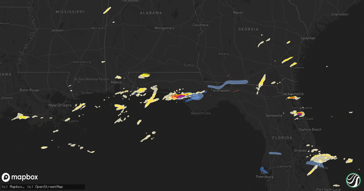
Hail Map on April 27, 2023
Get this storm
April 27 map
$229
one time, instant access
Download today. No call, no setup
Keep the $229
Bought the map and want the full workflow? Apply the entire $229 to a subscription within 7 days. None of it is wasted.
Every map, not just this one
This buys you this map. Subscription and you get every map we run, in the markets you choose from a few cities to whole states to nationwide. Plus real-time alerts the moment a storm fires.
Contact data
Name, contact info, occupancy, even credit band for addresses in the footprint. You go from where it hit to who to call.
Become the source they trust
Unlimited branding weather history reports on demand. You already have the documented answer ready for the property owner, and you are the one who showed up with it.
Property data and RoofTrace estimates
Pull up any address you have got, its value and the exact code rules for that jurisdiction, straight from One Click Code. Then RoofTrace estimates the squares, pitch, and roof value, priced the way you price.
States Impacted by Hail Map on April 27, 2023
Storm reports
Florida
| Date | Description |
|---|---|
| 04/27/20236:57 PM CDT | Numerous trees down along ne hwy 351. |
| 04/27/20236:55 PM CDT | Trees down along se hwy 346. |
| 04/27/20236:51 PM CDT | Numerous trees down along se 471 st. |
| 04/27/20236:50 PM CDT | Numerous trees down along 122 st. |
| 04/27/20236:50 PM CDT | Trees down along ne 118 st. |
| 04/27/20236:00 PM CDT | Estimated 1.25 inch hail in buckhead ridge. Delayed report via social media. |
| 04/27/20235:42 PM CDT | Well defined tds on radar. |
| 04/27/20235:37 PM CDT | Tree down along us-19. |
| 04/27/20235:30 PM CDT | Tree down over roadway. |
| 04/27/20235:30 PM CDT | Tree down across roadway bannerman and tequesta. |
| 04/27/20235:30 PM CDT | Spotter reports quarter sized hail in cocoa near adamson rd |
| 04/27/20235:25 PM CDT | Trees down meridian and orchard pond. |
| 04/27/20235:20 PM CDT | Trees down on trimble road. |
| 04/27/20235:20 PM CDT | Tree down over the road at ocala and tharpe. |
| 04/27/20235:18 PM CDT | Report of downed trees in havanna. |
| 04/27/20235:15 PM CDT | Confirmed tds on radar. |
| 04/27/20235:15 PM CDT | Tree down on home in the 2900 block of stokley lane. |
| 04/27/20235:07 PM CDT | Spotter reports 60 to 70 mph wind gusts. Power outages. |
| 04/27/20235:00 PM CDT | Fallen trees and limbs resulted in a power outage. |
| 04/27/20234:45 PM CDT | 911 dispatch reports numerous trees down across the entire county due to severe storms moving through. |
| 04/27/20234:30 PM CDT | Social media submitted video of hail on ground. |
| 04/27/20234:23 PM CDT | Brief tds on radar. |
| 04/27/20234:10 PM CDT | A local report indicates 1.75 inch wind near 1 NNW HASTINGS |
| 04/27/20234:00 PM CDT | Several trees down in calhoun county. |
| 04/27/20233:33 PM CDT | Well defined tds on radar. |
| 04/27/20233:24 PM CDT | Awos station knip jacksonville nas. |
| 04/27/20233:20 PM CDT | Storm report submitted. Time estimated from radar. |
| 04/27/20233:20 PM CDT | Storm report submitted. Damage to wooden fence. Time estimated from radar. |
| 04/27/20233:15 PM CDT | Downed trees... Roof damage to supermarket... And 1/4 inch hail reported. Time of event estimated via radar. |
| 04/27/20233:15 PM CDT | Downed trees... Roof damage to su |
| 04/27/20233:15 PM CDT | Social media. Photos of trees down along claire ln and san jose jose blvd in jacksonville... Fl. Time radar estimated. |
| 04/27/20233:05 PM CDT | 76 mph wind gusts from bay county sheriff office weatherstem. |
| 04/27/20233:05 PM CDT | Photos of structural damage with confirmed tds in the area. |
| 04/27/20233:04 PM CDT | Awos station kpam tyndall afb. |
| 04/27/20233:00 PM CDT | 58 mph gust as station pacf1. |
| 04/27/20233:00 PM CDT | Reported tree fell onto house. Time estimated from radar. |
| 04/27/20233:00 PM CDT | Report of pea to quarter sized hail falling at us 17 and i-295. |
| 04/27/20232:55 PM CDT | Downed trees along with damaged roof and interior at gas station near 295 and hwy 17. Time of event estimated via radar. |
| 04/27/20232:52 PM CDT | Damage in the hosford area with a confirmed tds on radar. |
| 04/27/20232:50 PM CDT | 2 trees down. 1 medium sized and 1 larger tree uprooted. Time radar estimated. |
| 04/27/20232:42 PM CDT | Ambient station gusted to 59 mph. |
| 04/27/20232:29 PM CDT | Tree down on highway 71 south near williams memorial. |
| 04/27/20231:08 PM CDT | There were many reports of hail around this size... Including at the eoc. Trees and power lines down as well at many locations across the county. |
| 04/27/20231:04 PM CDT | A local report indicates 1.75 inch wind near 1 N LYNN HAVEN |
| 04/27/20231:02 PM CDT | Report from mping: ping pong ball |
| 04/27/202312:35 PM CDT | Report from mping: 1-inch tree limbs broken; shingles blown off. |
| 04/27/202312:30 PM CDT | Public reported estimated quarter to half-dollar size hail at the interstection of hwy 79 and 98. |
| 04/27/202312:11 PM CDT | Multiple reports and videos on social media of half dollar size hail falling in ne pensacola. |
| 04/27/202312:02 PM CDT | Pensacola faa tower called to report quarter hail at kpns. |
| 04/26/202310:37 PM CDT | The asos at melbourne international airport |
| 04/26/202310:15 PM CDT | Strong winds flipped 3 small planes at merritt island airport |
| 04/26/20239:30 PM CDT | Emergency manager reports trees down/uprooted... Trees on roofs... And structural damage to homes near tavares and oakland park. |
| 04/26/20238:30 PM CDT | Trees and powerlines down. |
| 04/26/20238:15 PM CDT | Mesonet station fw8592 seminole. |
| 04/26/20238:14 PM CDT | Asos station kbkv brooksville. |
| 04/26/20237:51 PM CDT | Report from mping: 1-inch tree limbs broken; shingles blown off. |
| 04/26/20237:49 PM CDT | Delayed report of tree down on house. Estimated winds 35-45 mph. |
Kansas
| Date | Description |
|---|---|
| 04/27/20236:58 PM CDT | A local report indicates 60 MPH wind near 2 NNE GOODLAND |
| 04/27/20236:50 PM CDT | A local report indicates 59 MPH wind near 1 NNE GOODLAND |
| 04/27/20236:43 PM CDT | Off duty nws employee reports 60 mph winds lasting 10-15 minutes and blowing dust resulting in reductions to visibility less than a mile. |
| 04/27/20236:40 PM CDT | A local report indicates 58 MPH wind near 2 NNE GOODLAND |
| 04/26/20238:35 PM CDT | Sustained at 47 mph. |
| 04/26/20237:49 PM CDT | A local report indicates 62 MPH wind near 9 WSW WINONA |
| 04/26/20237:31 PM CDT | A local report indicates 60 MPH wind near 10 NE WALLACE |
Wyoming
| Date | Description |
|---|---|
| 04/27/20233:06 PM CDT | Asos station kcpr casper airport. Wind gust occurred with a line of storms along a strong cold front. |
| 04/27/20231:00 PM CDT | Asos station kwrl worland airport. Wind gust was associated with a line of thunderstorms along a strong cold front. |
| 04/27/202311:35 AM CDT | Awos station kpoy powell airport. Wind gusts were associated with vicinity thunderstorms along a strong cold front. |
Tennessee
| Date | Description |
|---|---|
| 04/27/20236:32 PM CDT | A local report indicates 1.00 inch wind near 4 S EADS |
| 04/27/20236:15 PM CDT | A local report indicates 1.00 inch wind near 2 WNW COLLIERVILLE |
| 04/27/20233:13 AM CDT | Tspotter report of quarter size hail. Severe thunderstorm warning in effect at time of report. |
Colorado
| Date | Description |
|---|---|
| 04/27/20236:09 PM CDT | Sustained at 44 mph. |
| 04/27/20235:59 PM CDT | Report from mping: 1-inch tree limbs broken; shingles blown off. |
| 04/27/20235:55 PM CDT | Public report of estimated winds 50-60 mph. Time and location estimated. |
| 04/27/20235:30 PM CDT | A local report indicates 61 MPH wind near 5 NNW HEARTSTRONG |
Georgia
| Date | Description |
|---|---|
| 04/27/20236:57 PM CDT | Tree down across adams road. |
| 04/27/20236:56 PM CDT | Ambient weather station gusted to 58 mph. |
| 04/27/20236:56 PM CDT | Tree down along rocky ford rd. |
| 04/27/20236:45 PM CDT | Report from mping: 3-inch tree limbs broken; power poles broken. |
| 04/27/20236:45 PM CDT | Several trees down along madison hwy. |
| 04/27/20236:30 PM CDT | Report from mping: trees uprooted or snapped. |
| 04/27/20236:30 PM CDT | Report from mping: trees uprooted or snapped;. |
| 04/27/20235:35 PM CDT | Conveyed report from 911 call center that hwy 99 is shutdown from hwy 32 to hwy 82...due to trees across roadway. Gdot in route. |
| 04/27/20235:18 PM CDT | County dispatcher reports trees down near where tds was observed on ktlh radar. |
| 04/27/20234:15 PM CDT | Corrects previous tstm wnd dmg report from 4 sse thalmann. Conveyed report from 911 call center that hwy 99 is shutdown from hwy 32 to hwy 82...due to trees across road |
| 04/27/20233:58 PM CDT | Delayed report. Tree across road caused by tstm winds. |
| 04/27/20232:55 PM CDT | Delayed report of tree down across road. |
| 04/27/20232:45 PM CDT | Received pictures of damage to the metal roof of an outbuilding as well as 2 trees snapped at the top. Time estimated from radar. |
| 04/26/20237:14 PM CDT | Tree down near highpoint and blairstone. |
| 04/26/20237:12 PM CDT | Trees down in the clyattville area. |
Mississippi
| Date | Description |
|---|---|
| 04/27/20236:53 PM CDT | Trees downed east tibbee and old tibbee rd. |
| 04/27/20236:13 PM CDT | Trees downed n beasly rd in pheba. |
| 04/27/20236:10 PM CDT | Along officers lake rd. |
| 04/27/20235:43 PM CDT | Hail at old waverly golf course... A few stones up to quarter size. |
| 04/27/20234:58 PM CDT | Golf ball hail occurred along sellers road. |
| 04/26/20239:22 PM CDT | Ping-pong sized hail fell about 2 miles south of sarah. |
| 04/26/20237:18 PM CDT | Trees downed on hospital dr... Military rd and 7th avenue n. |
| 04/26/20237:11 PM CDT | Trees down: plymouth buff access rd... Old west point rd... Taylor thurston rd... And steager rd. |
Nebraska
| Date | Description |
|---|---|
| 04/27/20235:46 PM CDT | Delayed report. Thunderstorm outflow. |
| 04/27/20234:33 PM CDT | Delayed report. Time estimated by radar. |
Alabama
| Date | Description |
|---|---|
| 04/27/202311:47 AM CDT | Retired nws employee reports quarter size hail in foley. Time using radar. |
| 04/27/20231:51 AM CDT | Hail to golf ball in size east of cullman near us hwy 278. |
| 04/27/20231:51 AM CDT | Quarter hail near eva rd / cr157. |
| 04/27/20231:45 AM CDT | Significant damage to metal roofing at the stiefelmeyer building in cul |
| 04/27/20231:45 AM CDT | Significant damage to metal roofing at the stiefelmeyer building in cullman... Al. Wind speeds estimated at 60-70 mph based on damage photos received via social media. |
| 04/27/20231:45 AM CDT | Social media report of approximately 2 in. Diameter hailstone in the larkwood subdivision of cullman... Al. Size was estimated based on picture. |
Arkansas
| Date | Description |
|---|---|
| 04/27/20236:42 PM CDT | A local report indicates 1.00 inch wind near 3 SSE STUTTGART MUNICIP |
| 04/27/20236:39 PM CDT | A local report indicates 1.25 inch wind near 4 S ULM |
| 04/27/20235:28 PM CDT | A local report indicates 1.00 inch wind near COY |
| 04/27/20235:17 PM CDT | A local report indicates 1.00 inch wind near ENGLAND |
| 04/26/20237:04 PM CDT | Trees and powerlines down. |
Texas
| Date | Description |
|---|---|
| 04/27/20239:35 AM CDT | Hail was mostly quarter size but some were as large as ping pong balls. |
| 04/27/20239:10 AM CDT | Member of the public shared a picture of a hail stone that is estimated to be about quarter-sized in the hebbronville area around 9:10 am cdt. |
Cities Impacted by Hail Map on April 27, 2023
- Waynesboro, MS
- Shubuta, MS
- Franklin, LA
- Patterson, LA
- Woodsboro, TX
- Refugio, TX
- Jay, FL
- Milton, FL
- Baker, FL
- Pensacola, FL
- Panama City Beach, FL
- Panama City, FL
- Lynn Haven, FL
- Youngstown, FL
- Satsuma, AL
- Daphne, AL
- Bay Minette, AL
- Port Sulphur, LA
- Braithwaite, LA
- Orange Beach, AL
- Saraland, AL
- Creola, AL
- State Line, MS
- Larose, LA
- Summerdale, AL
- Silverhill, AL
- Foley, AL
- Elberta, AL
- Dauphin Island, AL
- Picayune, MS
- Carriere, MS
- Stennis Space Center, MS
- Realitos, TX
- Golden Meadow, LA
- Gibson, LA
- Hebbronville, TX
- Lillian, AL
- Inlet Beach, FL
- Gulf Shores, AL
- Fairhope, AL
- Magnolia Springs, AL
- Aransas Pass, TX
- Houma, LA
- Berwick, LA
- Gulf Breeze, FL
- Wewahitchka, FL
- Blountstown, FL
- Jacksonville, FL
- Orange Park, FL
- Hosford, FL
- Bristol, FL
- Freeport, FL
- Ponce De Leon, FL
- Ebro, FL
- Vernon, FL
- Defuniak Springs, FL
- Hortense, GA
- Screven, GA
- Clarksville, FL
- Brunswick, GA
- Hastings, FL
- East Palatka, FL
- Elkton, FL
- Mayo, FL
- Branford, FL
- High Springs, FL
- Sopchoppy, FL
- Florahome, FL
- Fort White, FL
- Keystone Heights, FL
- Waldo, FL
- Gainesville, FL
- Alachua, FL
- Perry, FL
- Palatka, FL
- Melrose, FL
- Saint Augustine, FL
- Jesup, GA
- Starkville, MS
- Havana, FL
- Thomasville, GA
- Cocoa, FL
- Quincy, FL
- Gretna, FL
- Midway, FL
- Tallahassee, FL
- Greenville, FL
- West Point, MS
- Columbus, MS
- England, AR
- Uvalda, GA
- Lumber City, GA
- Blackshear, GA
- Tryon, NE
- Live Oak, FL
- Jasper, FL
- Alamo, GA
- Fargo, GA
- Homerville, GA
- Chipley, FL
- Christmas, FL
- Maben, MS
- Pheba, MS
- Saint Cloud, FL
- Jacksonville, GA
- Titusville, FL
- Glennville, GA
- Ludowici, GA
- Palm Coast, FL
- Oviedo, FL
- Geneva, FL
- Patterson, GA
- Ingleside, TX
- Eglin Afb, FL
- Orlando, FL
- Ponte Vedra Beach, FL
- Santa Rosa Beach, FL
- Mary Esther, FL
- Fort Walton Beach, FL
- Shalimar, FL
- Humnoke, AR
- Ulm, AR
- Carlisle, AR
- Stuttgart, AR
- Okeechobee, FL
- Cape Canaveral, FL
- Steens, MS
- Wabbaseka, AR
- Humphrey, AR
- Kenansville, FL
- Almyra, AR
- Roe, AR
- Casscoe, AR
- Collierville, TN
- Eads, TN
- Clarendon, AR
- Holly Grove, AR
- Monticello, FL
- Boston, GA
- Dixie, GA
- Quitman, GA
- Valdosta, GA
- Marvell, AR
- Reform, AL
- Millport, AL
- Ethelsville, AL
- Dunedin, FL
- Safety Harbor, FL
- Pinellas Park, FL
- Seminole, FL
- Clearwater, FL
- Saint Petersburg, FL
- Largo, FL
- Helena, AR
- Dundee, MS
- Spring Hill, FL
- Brooksville, FL
- Dade City, FL
- Webster, FL
- Sledge, MS
- Crenshaw, MS
- Sarah, MS
- Como, MS
- Sardis, MS
- Melbourne, FL
- Merritt Island, FL
- Satellite Beach, FL
- Indialantic, FL
- Palm Bay, FL
- Melbourne Beach, FL
- De Witt, AR
- Altheimer, AR
- Hazen, AR
- Gordo, AL
- Brinkley, AR
- De Valls Bluff, AR
- Aubrey, AR
- Little Rock, AR
- Hensley, AR
- Mabelvale, AR
- Malabar, FL
- Saint Charles, AR
- Elaine, AR
- Hoxie, KS
- Grinnell, KS
- Oakley, KS
- Crocketts Bluff, AR
- Scooba, MS
- West Helena, AR
- Lexa, AR
- Poplar Grove, AR
- Memphis, TN
- Aliceville, AL
- Emelle, AL
- Rockledge, FL
- Mims, FL
- Cedarbluff, MS
- Mantee, MS
- Mathiston, MS
- Canal Point, FL
- Indiantown, FL
- Tichnor, AR
- Cocoa Beach, FL
- Patrick Afb, FL
- Germantown, TN
- Cullman, AL
- Brookwood, AL
- Tuscaloosa, AL
- Livingston, AL
- Columbia, TN
- Walnut, MS
- Corinth, MS
- Rienzi, MS
- Ripley, MS
- Minter City, MS
- Philipp, MS
- Macon, MS
- Tiplersville, MS
- Lexington, TN
- Hohenwald, TN
- Oxford, MS
- Logan, AL
- Addison, AL
- Houston, AL
- Double Springs, AL
- Arley, AL
- Crane Hill, AL
- Holcomb, MS
- Northport, AL
- Elrod, AL
- University, MS
- Thaxton, MS
- Coker, AL
- Mount Pleasant, TN
- Holly Pond, AL
- Culleoka, TN
- Lewisburg, TN
- Hampshire, TN
- Blountsville, AL