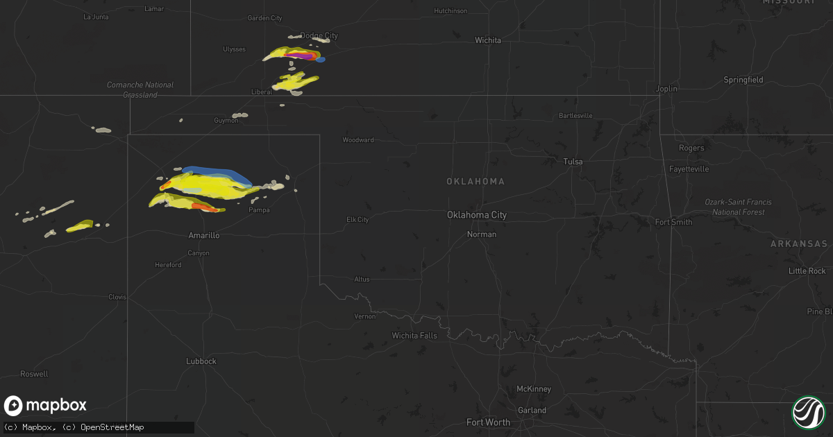
Hail Map in Oklahoma on April 27, 2022
Get this storm
April 27 map
$229
one time, instant access
Download today. No call, no setup
Keep the $229
Bought the map and want the full workflow? Apply the entire $229 to a subscription within 7 days. None of it is wasted.
Every map, not just this one
This buys you this map. Subscription and you get every map we run, in the markets you choose from a few cities to whole states to nationwide. Plus real-time alerts the moment a storm fires.
Contact data
Name, contact info, occupancy, even credit band for addresses in the footprint. You go from where it hit to who to call.
Become the source they trust
Unlimited branding weather history reports on demand. You already have the documented answer ready for the property owner, and you are the one who showed up with it.
Property data and RoofTrace estimates
Pull up any address you have got, its value and the exact code rules for that jurisdiction, straight from One Click Code. Then RoofTrace estimates the squares, pitch, and roof value, priced the way you price.
Storm reports in Oklahoma
Oklahoma
| Date | Description |
|---|---|
| 04/27/20224:30 AM CDT | A local report indicates 58 MPH wind near 3 SSW FREEDOM |
| 04/27/20223:37 AM CDT | At 837 PM CDT, severe thunderstorms were located along a line extending from near Kingsdown to near Ashland to 7 miles northeast of Knowles, moving east at 20 mph. HAZARD...60 mph wind gusts. SOURCE...Radar indicated. IMPACT...Expect damage to roofs, siding, and trees. Severe thunderstorms will be near... Ashland around 845 PM CDT.Other locations in the path of these severe thunderstorms includeSitka and Acres. |
| 04/27/20222:36 AM CDT | At 735 PM CDT, a severe thunderstorm was located near Liberal, moving east at 25 mph. HAZARD...60 mph wind gusts and quarter size hail. SOURCE...Radar indicated. IMPACT...Hail damage to vehicles is expected. Expect wind damage to roofs, siding, and trees. This severe thunderstorm will be near... Hayne around 745 PM CDT. |
| 04/27/20222:35 AM CDT | At 734 PM CDT, a severe thunderstorm was located over Adams, or 19 miles east of Guymon, moving east at 25 mph. HAZARD...60 mph wind gusts and quarter size hail. SOURCE...Radar indicated. IMPACT...Minor damage to roofs, siding, and trees is possible. Hail damage to vehicles is expected. Locations impacted include... Hooker, Turpin, Bryans Corner, Baker, Adams and Boyd. |
Cities Impacted by Hail Map on April 27, 2022
- Fowler, KS
- Borger, TX
- Ford, KS
- Dodge City, KS
- Channing, TX
- Vega, TX
- Hartley, TX
- Stinnett, TX
- Conchas Dam, NM
- San Jon, NM
- Copeland, KS
- Sublette, KS
- Montezuma, KS
- Meade, KS
- Plains, KS
- Ensign, KS
- Minneola, KS
- Liberal, KS
- Kismet, KS
- Dumas, TX
- Sunray, TX
- Dalhart, TX
- Fritch, TX
- Miami, TX
- Morse, TX
- Skellytown, TX
- Englewood, KS
- Guymon, OK
- Hooker, OK
- Grenville, NM
- Cuervo, NM
- Newkirk, NM
- Masterson, TX
- Amarillo, TX
- Cimarron, KS
- Ingalls, KS
- Garita, NM
- Tucumcari, NM
- Canadian, TX
- Forgan, OK
- Wright, KS
- Texhoma, OK
- Trementina, NM
- Wallingford, IA
- Ringsted, IA
- Pampa, TX
- Matheson, CO
- Limon, CO
- Logan, NM
- Stratford, TX
- Cactus, TX


