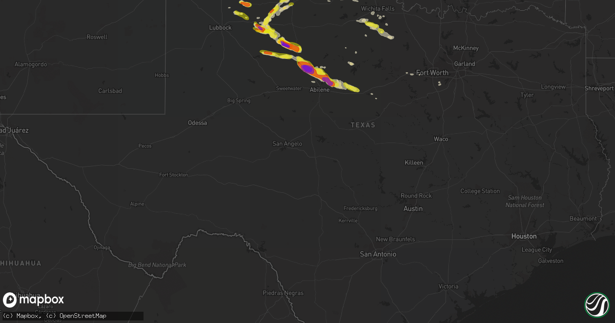
Hail Map in Texas on April 27, 2019
Get this storm
April 27 map
$229
one time, instant access
Download today. No call, no setup
Keep the $229
Bought the map and want the full workflow? Apply the entire $229 to a subscription within 7 days. None of it is wasted.
Every map, not just this one
This buys you this map. Subscription and you get every map we run, in the markets you choose from a few cities to whole states to nationwide. Plus real-time alerts the moment a storm fires.
Contact data
Name, contact info, occupancy, even credit band for addresses in the footprint. You go from where it hit to who to call.
Become the source they trust
Unlimited branding weather history reports on demand. You already have the documented answer ready for the property owner, and you are the one who showed up with it.
Property data and RoofTrace estimates
Pull up any address you have got, its value and the exact code rules for that jurisdiction, straight from One Click Code. Then RoofTrace estimates the squares, pitch, and roof value, priced the way you price.
Storm reports in Texas
Texas
| Date | Description |
|---|---|
| 04/27/20196:54 PM CDT | Trained spotter found the hail on the ground after storm passed |
| 04/27/20196:45 PM CDT | A local report indicates 2.75 inch wind near 2 SE JAYTON |
| 04/27/20196:25 PM CDT | Hail falling at time of report |
| 04/27/20196:02 PM CDT | Late report of ping pong size hail on highway 385 north of vega. |
| 04/27/20196:02 PM CDT | Late report of ping pong size hail on highway 385 north of vega. |
| 04/27/20195:18 PM CDT | A local report indicates 1.25 inch wind near 5 W SPUR |
| 04/27/20195:10 PM CDT | Trained storm spotter reported via twitter both quarter and half-dollar sized hail |
| 04/27/20195:05 PM CDT | Hail was just starting. |
| 04/27/20194:32 AM CDT | At 932 PM CDT, a severe thunderstorm was located near Cisco, moving east at 45 mph. HAZARD...60 mph wind gusts and quarter size hail. SOURCE...Radar indicated. IMPACT...Hail damage to vehicles is expected. Expect wind damage to roofs, siding, and trees. Locations impacted include... Eastland, Cisco, Ranger, Gorman, Gunsight, Carbon and I-20 Near The Callahan-Eastland County Line.This includes Interstate 20 between mile markers 324 and 362. |
| 04/27/20194:10 AM CDT | Quarter size hail perhaps larger. |
| 04/27/20193:34 AM CDT | At 833 PM CDT, a severe thunderstorm was located 8 miles northeast of Hamby, or 14 miles north of Clyde, moving southeast at 35 mph. HAZARD...70 mph wind gusts and half dollar size hail. SOURCE...Radar indicated. IMPACT...Hail damage to vehicles is expected. Expect considerable tree damage. Wind damage is also likely to mobile homes, roofs, and outbuildings. This severe thunderstorm will remain over mainly rural areas of northwestern Callahan, southeastern Jones and southern Shackelford Counties, including the following locations... Mccarty Lake and Us-283 Near The Callahan-Shackelford County Line.This includes Interstate 20 between Mile Markers 299 and 314. |
| 04/27/20193:08 AM CDT | At 808 PM CDT, a severe thunderstorm was located near Anson, moving southeast at 30 mph. HAZARD...Two inch hail and 70 mph wind gusts. SOURCE...Radar indicated. IMPACT...People and animals outdoors will be injured. Expect hail damage to roofs, siding, windows, and vehicles. Expect considerable tree damage. Wind damage is also likely to mobile homes, roofs, and outbuildings. This severe thunderstorm will be near... Hawley around 820 PM CDT. Nugent around 825 PM CDT. Abilene around 830 PM CDT.Other locations impacted by this severe thunderstorm include Funston,Impact, Hodges, Lake Fort Phantom Hill, Truby and The Intersection OfUs-180 And Farm Road 600.This includes Interstate 20 between Mile Markers 280 and 284. |
| 04/27/20192:37 AM CDT | At 737 PM CDT, a severe thunderstorm was located near Hamlin, moving southeast at 30 mph. HAZARD...Tennis ball size hail and 70 mph wind gusts. SOURCE...Radar indicated. IMPACT...People and animals outdoors will be injured. Expect hail damage to roofs, siding, windows, and vehicles. Expect considerable tree damage. Wind damage is also likely to mobile homes, roofs, and outbuildings. This severe thunderstorm will be near... Neinda around 745 PM CDT. Anson around 800 PM CDT.Other locations impacted by this severe thunderstorm include Funston,The Intersection Of Us-180 And Ranch Road 126 and Tuxedo. |
| 04/27/20192:20 AM CDT | At 720 PM CDT, a severe thunderstorm was located near Aspermont, moving east at 25 mph. HAZARD...Two inch hail and 60 mph wind gusts. SOURCE...Trained weather spotters. IMPACT...People and animals outdoors will be injured. Expect hail damage to roofs, siding, windows, and vehicles. Expect wind damage to roofs, siding, and trees. Locations impacted include... Aspermont, Old Glory and Us-380 Near The Haskell- Stonewall County Line. |
| 04/27/20192:08 AM CDT | At 708 PM CDT, a severe thunderstorm was located 7 miles north of Hamlin, moving east at 50 mph. HAZARD...60 mph wind gusts and quarter size hail. SOURCE...Radar indicated. IMPACT...Hail damage to vehicles is expected. Expect wind damage to roofs, siding, and trees. This severe thunderstorm will be near... Sagerton around 720 PM CDT. Stamford around 745 PM CDT.Other locations impacted by this severe thunderstorm include Hitsonand Tuxedo. |
| 04/27/20191:39 AM CDT | At 639 PM CDT, a severe thunderstorm was located 11 miles southwest of Peacock, or 14 miles south of Jayton, moving east at 20 mph. HAZARD...60 mph wind gusts and quarter size hail. SOURCE...Radar indicated. IMPACT...Hail damage to vehicles is expected. Expect wind damage to roofs, siding, and trees. This severe thunderstorm will remain over mainly rural areas of southern Stonewall County. |
| 04/27/20191:33 AM CDT | At 633 PM CDT, a severe thunderstorm was located 7 miles northeast of Jayton, moving east at 20 mph. HAZARD...60 mph wind gusts and quarter size hail. SOURCE...Radar indicated. IMPACT...Hail damage to vehicles is expected. Expect wind damage to roofs, siding, and trees. Locations impacted include... Aspermont, Jayton, Peacock and Swenson. |
| 04/27/20191:01 AM CDT | At 601 PM CDT, a severe thunderstorm was located 4 miles northeast of Vega, moving southeast at 25 mph. HAZARD...60 mph wind gusts and quarter size hail. SOURCE...Radar indicated. IMPACT...Minor damage to roofs, siding, and trees is possible. Hail damage to vehicles is expected. Locations impacted include... Vega, Wildorado and Bushland. |
| 04/27/20191:00 AM CDT | At 600 PM CDT, a severe thunderstorm was located 8 miles east of Lake Alan Henry, moving east at 25 mph. HAZARD...60 mph wind gusts and quarter size hail. SOURCE...Radar indicated. IMPACT...Hail damage to vehicles is expected. Expect wind damage to roofs, siding, and trees. This severe thunderstorm will remain over mainly rural areas of southern Kent County. |
| 04/27/201912:56 AM CDT | At 555 PM CDT, a severe thunderstorm was located 5 miles northwest of Spur, moving east at 15 mph. HAZARD...60 mph wind gusts and half dollar size hail. SOURCE...Radar indicated. IMPACT...Hail damage to vehicles is expected. Expect wind damage to roofs, siding, and trees. Locations impacted include... Spur, Dickens and Girard. |
| 04/27/201912:44 AM CDT | At 544 PM CDT, a severe thunderstorm was located near White River Lake, moving east at 25 mph. HAZARD...60 mph wind gusts and quarter size hail. SOURCE...Radar indicated. IMPACT...Hail damage to vehicles is expected. Expect wind damage to roofs, siding, and trees. Locations impacted include... Spur and White River Lake. |
| 04/27/201912:17 AM CDT | At 517 PM CDT, a severe thunderstorm was located over Afton, or 7 miles north of Dickens, moving northeast at 25 mph. HAZARD...Ping pong ball size hail and 60 mph wind gusts. SOURCE...Radar indicated. IMPACT...People and animals outdoors will be injured. Expect hail damage to roofs, siding, windows, and vehicles. Expect wind damage to roofs, siding, and trees. Locations impacted include... Finney, Delwin, Afton and Dumont. |
| 04/27/201912:02 AM CDT | At 502 PM CDT, a severe thunderstorm was located 6 miles east of White River Lake, moving east at 25 mph. HAZARD...60 mph wind gusts and quarter size hail. SOURCE...Radar indicated. IMPACT...Hail damage to vehicles is expected. Expect wind damage to roofs, siding, and trees. Locations impacted include... Spur, Dickens, White River Lake, Girard and Mcadoo. |
| 04/26/201911:56 PM CDT | At 456 PM CDT, a severe thunderstorm was located 5 miles west of Floydada, moving east at 20 mph. HAZARD...60 mph wind gusts and quarter size hail. SOURCE...Radar indicated. IMPACT...Hail damage to vehicles is expected. Expect wind damage to roofs, siding, and trees. Locations impacted include... Floydada and Dougherty. |
| 04/26/201911:20 PM CDT | At 419 PM CDT, a severe thunderstorm was located 5 miles southeast of Petersburg, or 14 miles southwest of Floydada, moving east at 30 mph. HAZARD...60 mph wind gusts and quarter size hail. SOURCE...Radar indicated. IMPACT...Hail damage to vehicles is expected. Expect wind damage to roofs, siding, and trees. Locations impacted include... Dougherty and Cone. |
| 04/26/201910:59 PM CDT | At 359 PM CDT, a severe thunderstorm was located over Romero, or 10 miles northeast of Nara Visa, moving southeast at 30 mph. HAZARD...60 mph wind gusts and quarter size hail. SOURCE...Radar indicated. IMPACT...Minor damage to roofs, siding, and trees is possible. Hail damage to vehicles is expected. Locations impacted include... Romero. |
| 04/26/20198:00 PM CDT | A local report indicates 1.00 inch wind near 2 E ANSON |
| 04/26/20197:56 PM CDT | A trained spotter reported quarter to golf ball size hail in anson. In addition... Winds were estimated to near 50 mph. |
| 04/26/20197:25 PM CDT | Falling now... Wind driven hail |
| 04/26/20197:15 PM CDT | A local report indicates 1.50 inch wind near ASPERMONT |
| 04/26/20197:11 PM CDT | Hail was getting larger but observer needed to go take shelter from possible tornado |
| 04/26/20197:09 PM CDT | A local report indicates 2.00 inch wind near 1 N PEACOCK |
| 04/26/20197:03 PM CDT | Hail broke out windshield of sheriff car |
All States Impacted by Hail Map on April 27, 2019
Cities Impacted by Hail Map on April 27, 2019
- Windthorst, TX
- Archer City, TX
- Scotland, TX
- Holliday, TX
- Canyon, TX
- Altus, OK
- Old Glory, TX
- Jayton, TX
- Aspermont, TX
- Vega, TX
- Wildorado, TX
- Snyder, TX
- Afton, TX
- Roaring Springs, TX
- Anson, TX
- Aledo, TX
- Weatherford, TX
- Moran, TX
- Cisco, TX
- Paducah, TX
- Floydada, TX
- Dickens, TX
- Albany, TX
- Abilene, TX
- Lueders, TX
- Rotan, TX
- Stamford, TX
- Eastland, TX
- Hamlin, TX
- Baird, TX
- Avoca, TX
- Clyde, TX
- Hawley, TX
- Breckenridge, TX
- Crosbyton, TX
- Mansfield, TX
- Vernon, TX
- Lawton, OK
- Crowell, TX
- Girard, TX
- Spur, TX
- Childress, TX
- Quanah, TX
- Kress, TX
- Tulia, TX
- Lorenzo, TX
- Ralls, TX
- Ranger, TX
- Adrian, TX
- Amarillo, TX
- Chillicothe, TX
- Mosquero, NM
- Jacksboro, TX
- Grenville, NM
- Dimmitt, TX
- Happy, TX
- Olney, TX
- Hereford, TX
- Claude, TX
- Plainview, TX
- Henrietta, TX
- Bowie, TX
- Lockney, TX
- Matador, TX
- Clarksville, AR
- Wichita Falls, TX
- Alvarado, TX
- Blair, OK
- Apache, OK
- Carnegie, OK
- Petersburg, TX
- Nara Visa, NM
- Amistad, NM
- Throckmorton, TX
- Newcastle, TX
- Woodson, TX
- Electra, TX
- Harrold, TX
- Desdemona, TX
- Merkel, TX
- Wayside, TX


