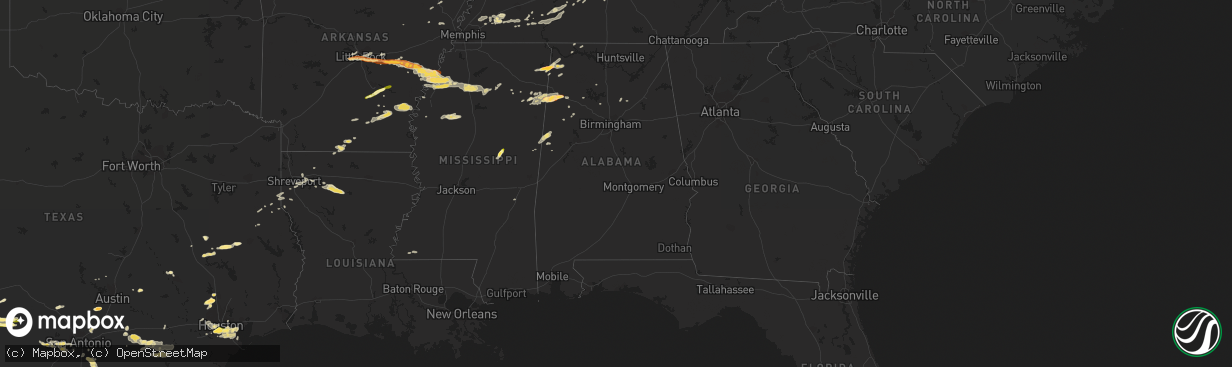
Hail Map in Alabama on April 27, 2013
The weather event in Alabama on April 27, 2013 includes Hail map. 7 states and 337 cities were impacted and suffered possible damage. The total estimated number of properties impacted is 1,206.
Want more than just the map?
Turn this storm into a full workflow.
- Owner + property data so you know who to knock
- OnDemand branded weather history reports to win the "did we even have hail?" argument
- RoofTrace estimate so reps stop guessing numbers at the door
Bought this map? Upgrade within 7 days and we'll credit the $230. (10-15 min setup call)
Hail
1,206
Estimated number of impacted properties by a 1.00" hail or larger150
Estimated number of impacted properties by a 1.75" hail or larger0
Estimated number of impacted properties by a 2.50" hail or largerStorm reports in Alabama
Alabama
| Date | Description |
|---|---|
| 04/27/20135:59 PM CDT | Pea to quarter size hail reported in mcshan. Reported through social media. |
| 04/27/20135:34 PM CDT | 4 trees down along mount hebron road...one of which was large and was blocking the road. |
| 04/27/20135:24 PM CDT | Estimated at 60 to 65 mph. Also with penny size hail. |
| 04/27/20135:08 AM CDT | Tree down on wagnon mountain road. |
| 04/27/20132:22 AM CDT | Relayed via social media/chat |
| 04/27/20131:40 AM CDT | Tree down on a powerline on hickerson avenue. Smoke smelled in an adjacent residence. |
| 04/27/20131:36 AM CDT | Tree down on loop road. |
| 04/27/20131:15 AM CDT | Tree down on wagnon mountain road. Time estimated from radar. |
All States Impacted by Hail Map on April 27, 2013
Cities Impacted by Hail Map on April 27, 2013
- Lexington, TX
- Belmont, MS
- Dennis, MS
- Watson, AR
- Tillar, AR
- Little Rock, AR
- Scott, AR
- Hallettsville, TX
- Centreville, MS
- Lambert, MS
- Marks, MS
- Apple Springs, TX
- Mason, TN
- Amory, MS
- Rocksprings, TX
- Batesville, MS
- Enid, MS
- Pope, MS
- Courtland, MS
- Water Valley, MS
- Oakland, MS
- Pine Bluff, AR
- Dryden, TX
- Beaverton, AL
- Sulligent, AL
- Del Rio, TX
- Comstock, TX
- Elmendorf, TX
- Whiteville, TN
- Stanton, TN
- Somerville, TN
- Von Ormy, TX
- Missouri City, TX
- Houston, TX
- Friendswood, TX
- Alvin, TX
- Pasadena, TX
- League City, TX
- Pearland, TX
- Webster, TX
- Deer Park, TX
- Seabrook, TX
- La Porte, TX
- South Houston, TX
- Parkin, AR
- Barksdale, TX
- Camp Wood, TX
- Gary, TX
- Tenaha, TX
- Lobelville, TN
- Lyles, TN
- Centerville, TN
- Florence, AL
- Bossier City, LA
- Keatchie, LA
- Southside, TN
- Groveton, TX
- Kennard, TX
- Crockett, TX
- Pennington, TX
- Star City, AR
- Grady, AR
- Linden, TN
- Decaturville, TN
- Trumann, AR
- Bay, AR
- Augusta, AR
- Golden, MS
- Russellville, AL
- Red Bay, AL
- New Site, MS
- Greenwood Springs, MS
- Detroit, AL
- Monticello, AR
- Wilmar, AR
- Hondo, TX
- D Hanis, TX
- Marvell, AR
- Holly Grove, AR
- Poplar Grove, AR
- Leakey, TX
- Guin, AL
- Schlater, MS
- Greenwood, MS
- Liberty, TN
- Dowelltown, TN
- Poth, TX
- Falls City, TX
- Floresville, TX
- Gunnison, MS
- El Dorado, AR
- Yoakum, TX
- Shiner, TX
- Clarksville, TN
- Cunningham, TN
- Carthage, TX
- Okolona, MS
- Shannon, MS
- Lovelady, TX
- Midway, TX
- Logansport, LA
- Killen, AL
- Winfield, AL
- Brilliant, AL
- Laredo, TX
- Spring, TX
- Magnolia, TX
- Pinehurst, TX
- Conroe, TX
- Friars Point, MS
- Elaine, AR
- Coahoma, MS
- Clarksdale, MS
- Helena, AR
- Carlisle, AR
- Roe, AR
- England, AR
- Clarendon, AR
- Casscoe, AR
- Hazen, AR
- Lexa, AR
- De Valls Bluff, AR
- Dundee, MS
- Stuttgart, AR
- Lyon, MS
- Aberdeen, MS
- Sonora, TX
- Gonzales, TX
- Oneonta, AL
- Milan, TN
- Bradford, TN
- Trenton, TN
- Garrison, TX
- Timpson, TX
- Devine, TX
- Lytle, TX
- Atascosa, TX
- La Coste, TX
- Natalia, TX
- Castroville, TX
- Waelder, TX
- Harwood, TX
- Duck River, TN
- Doddsville, MS
- Bryan, TX
- Springfield, TN
- Greenbrier, TN
- Cross Plains, TN
- Cedar Hill, TN
- White House, TN
- Ashland City, TN
- Chapmansboro, TN
- Pleasant View, TN
- Rio Medina, TX
- San Antonio, TX
- Addison, AL
- Vinemont, AL
- North Little Rock, AR
- Banner, MS
- Sledge, MS
- Alexander, AR
- Lonoke, AR
- Oxford, MS
- Coffeeville, MS
- Carrollton, AL
- Savannah, TN
- Bath Springs, TN
- Cherokee, AL
- Ozona, TX
- Weiner, AR
- Harrisburg, AR
- Junction City, AR
- Toone, TN
- Medon, TN
- Henderson, TN
- Elgin, TX
- Cotulla, TX
- Dilley, TX
- Pearsall, TX
- New Braunfels, TX
- Cibolo, TX
- Marion, TX
- Pickens, AR
- Philadelphia, MS
- Louisville, MS
- Noxapater, MS
- Aliceville, AL
- Asherton, TX
- Macon, MS
- Shuqualak, MS
- Huntingdon, TN
- McKenzie, TN
- Adkins, TX
- Comfort, TX
- Edna, TX
- Louise, TX
- McCool, MS
- Carthage, MS
- Maumelle, AR
- Nacogdoches, TX
- Cleveland, AL
- Reform, AL
- Brooksville, MS
- Ethelsville, AL
- Liberty Hill, TX
- Rohwer, AR
- Winchester, AR
- Dumas, AR
- Tomball, TX
- Crocketts Bluff, AR
- Hornsby, TN
- Hodges, AL
- Spruce Pine, AL
- Hearne, TX
- Oakwood, TX
- Hamilton, AL
- Fulton, MS
- Smithville, MS
- Nashville, TN
- Kingston Springs, TN
- Driftwood, TX
- Wimberley, TX
- Buda, TX
- Grapeland, TX
- Greenfield, TN
- Erin, TN
- Hebbronville, TX
- Katy, TX
- Warren, AR
- Marietta, MS
- Tuscumbia, AL
- Bremen, AL
- Hampton, AR
- Quitman, LA
- Bienville, LA
- Jonesboro, LA
- Pontotoc, MS
- Sugar Land, TX
- Adams, TN
- Cumberland Furnace, TN
- Palmyra, TN
- Cottontown, TN
- Columbus, TX
- Glidden, TX
- Cumberland City, TN
- Adamsville, TN
- Finger, TN
- Bethel Springs, TN
- Tennessee Ridge, TN
- Woodville, MS
- Ganado, TX
- Rison, AR
- Dresden, TN
- Goodlettsville, TN
- Bertram, TX
- Spring Hill, TN
- Bellaire, TX
- Stafford, TX
- Kemah, TX
- Dickinson, TX
- Bacliff, TX
- Randolph, MS
- Garwood, TX
- Manvel, TX
- Rosharon, TX
- Fresno, TX
- Hollow Rock, TN
- El Campo, TX
- Sublime, TX
- Moulton, TX
- Cherry Valley, AR
- Harrell, AR
- Spring Branch, TX
- Lexington, AL
- Minden, LA
- Gibsland, LA
- De Berry, TX
- Keithville, LA
- Calliham, TX
- Brighton, TN
- Covington, TN
- Arlington, TN
- Jamestown, LA
- Castor, LA
- Fayette, AL
- Eldridge, AL
- Montgomery, TX
- Reagan, TN
- Joaquin, TX
- Pachuta, MS
- Bankston, AL
- Paris, MS
- Luray, TN
- Huron, TN
- Ruleville, MS
- Sunflower, MS
- Fairview, TN
- Haynesville, LA
- Atwood, TN
- Cleveland, MS
- Shaw, MS
- Boyle, MS
- Nauvoo, AL
- Haughton, LA
- Shreveport, LA
- Elm Grove, LA
- Doyline, LA
- Kenton, TN
- Sharon, TN
- Yorktown, AR
- Eutaw, AL
- Brownsville, TN
- Brentwood, TN
- Carrizo Springs, TX
- Centerville, TX
- Grand Cane, LA
- Lillie, LA
- Cadiz, KY
- Charlotte, TN
- Joelton, TN
- Dexter, KY
- Princeton, LA
- Hardin, KY
- Berry, AL
- Milledgeville, TN
- Morris Chapel, TN
- Clifton, TN
- Saltillo, TN
- Scotts Hill, TN
- Sardis, TN
- Fredericksburg, TX
- Sibley, LA
- Heflin, LA
- Nettleton, MS
- Ringgold, LA
- Jbsa Lackland, TX
- Altheimer, AR


