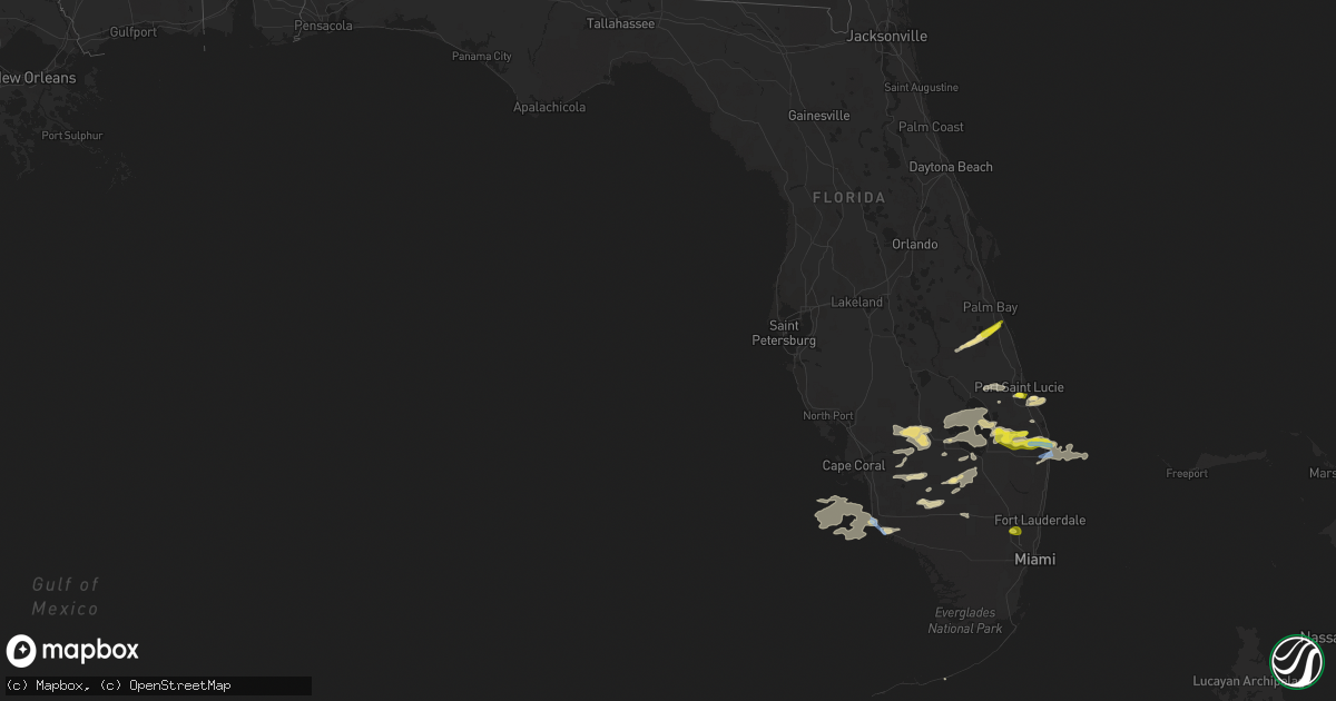
Hail Map in Florida on April 26, 2020
Get this storm
April 26 map
$229
one time, instant access
Download today. No call, no setup
Keep the $229
Bought the map and want the full workflow? Apply the entire $229 to a subscription within 7 days. None of it is wasted.
Every map, not just this one
This buys you this map. Subscription and you get every map we run, in the markets you choose from a few cities to whole states to nationwide. Plus real-time alerts the moment a storm fires.
Contact data
Name, contact info, occupancy, even credit band for addresses in the footprint. You go from where it hit to who to call.
Become the source they trust
Unlimited branding weather history reports on demand. You already have the documented answer ready for the property owner, and you are the one who showed up with it.
Property data and RoofTrace estimates
Pull up any address you have got, its value and the exact code rules for that jurisdiction, straight from One Click Code. Then RoofTrace estimates the squares, pitch, and roof value, priced the way you price.
Storm reports in Florida
Florida
| Date | Description |
|---|---|
| 04/26/20202:15 PM CDT | A trained spotter reported trees down near the intersection of hiatus road and pembroke road. |
| 04/26/20201:58 PM CDT | Small softwood tree snapped in west miramar. Time estimated from radar. |
| 04/26/20201:22 PM CDT | A report relayed by broadcast media... Report of quarter size hail in lake park. |
| 04/26/202012:35 PM CDT | A thunderstorm wind gust of 62 mph/ 54 knots was recorded by the weatherbug mesonet site rvrpb located at the rivera beach eoc. |
| 04/26/202012:27 PM CDT | A thunderstorm wind gust of 61 mph / 53 knots was reported by the weatherbug mesonet site wtpbh located at wpb fire station 1. |
| 04/26/202012:24 PM CDT | Power lines down near royal poinciana way and cocoanut row. Time estimated from radar. |
| 04/26/202012:22 PM CDT | A thunderstorm wind gust of 64 mph/ 56 knots reported by the wxflow mesonet station xmgn mangonia park. |
| 04/26/202012:19 PM CDT | A thunderstorm wind gust of 71 mph/ 62 knots was reported by the asos station kpbi west palm beach. |
| 04/26/202012:19 PM CDT | Power line down. Time estimated from radar. Pbi located nearby reported 62 kt / 71 mph gust at this time. |
| 04/26/202012:15 PM CDT | Reports of wires down in the area of royal pinciana way and cocoanut road. |
| 04/26/202012:15 PM CDT | A thunderstorm wind gust of 59 mph / 51 knots was recorded by the awos station kmky marco island. |
| 04/26/202012:13 PM CDT | Small dents to roofs of cars. Small branches down. |
| 04/26/202012:10 PM CDT | A ham radio operator relayed a report of tree damage located at the intersection of northlake blvd and ibis blvd. |
| 04/26/202012:10 PM CDT | A ham radio operator reported trees down and power outages near the intersection of okeechobee blvd and n jog road. |
| 04/26/202012:10 PM CDT | Report via twitter of quarter size hail near ballpark of the palm beaches. |
| 04/26/202012:09 PM CDT | Estimated 60+ mph winds. Trees down and nickel size hail. Located on royal palm beach blvd in loxahatchee. Time estimated from radar. |
| 04/26/202012:08 PM CDT | A broadcast media report/ photos of quarter sized hail in palm beach gardens. |
| 04/26/202012:08 PM CDT | Corrects time: a report relayed by broadcast media... Report of quarter size hail in lake park. |
| 04/26/202012:00 PM CDT | Broadcast media reported and relayed photos of quarter size hail in the acreage. |
| 04/26/202012:00 PM CDT | A broadcast media report from wink news relayed damage to homes... Trees down and power lines down. Time estimated via radar. |
| 04/26/202011:54 AM CDT | Royal palm snapped at base. Fell on house causing roof damage. Time estimated from radar. |
| 04/26/202011:52 AM CDT | Multiple royal palms snapped at base. Branches down. Street sign down. Time estimated from radar. |
| 04/26/20209:25 AM CDT | Trained spotter reported quarter size hail near port st lucie high school. And another report of 1.25 inch hail near north river shores. |
| 04/26/20208:27 AM CDT | Time estimated by radar. |
| 04/26/20208:07 AM CDT | Report of nickel to quarter size hail. |
| 04/26/20207:40 AM CDT | At 1239 PM EDT, a severe thunderstorm was located near Naples, moving east at 25 mph. HAZARD...60 mph wind gusts and quarter size hail. SOURCE...Radar indicated. IMPACT...Hail damage to vehicles is expected. Expect wind damage to roofs, siding, and trees. Locations impacted include... Naples, Marco Island, Golden Gate Estates, Cape Romano and Belle Meade. |
| 04/26/20207:36 AM CDT | At 1235 PM EDT, a severe thunderstorm was located near Muse, or 9 miles west of Palmdale, moving east at 25 mph. HAZARD...60 mph wind gusts and quarter size hail. SOURCE...Radar indicated. IMPACT...Hail damage to vehicles is expected. Expect wind damage to roofs, siding, and trees. Locations impacted include... Moore Haven, Lakeport, Palmdale, Ortona and Muse. |
| 04/26/20207:29 AM CDT | At 1228 PM EDT, a severe thunderstorm was located near Canal Point, moving east at 25 mph. HAZARD...60 mph wind gusts and quarter size hail. SOURCE...Radar indicated. IMPACT...Hail damage to vehicles is expected. Expect wind damage to roofs, siding, and trees. Locations impacted include... West Palm Beach, Boynton Beach, Wellington, Jupiter and Palm Beach Gardens. |
| 04/26/20207:04 AM CDT | At 1204 PM EDT, a severe thunderstorm was located over Felda, or near Immokalee, moving east at 25 mph. HAZARD...60 mph wind gusts and quarter size hail. SOURCE...Radar indicated. IMPACT...Hail damage to vehicles is expected. Expect wind damage to roofs, siding, and trees. Locations impacted include... Immokalee, Felda, Devils Garden, Keri and Bunker Hill. |
| 04/26/20205:30 AM CDT | At 1029 AM EDT, a severe thunderstorm was located over North River Shores, or near Stuart, moving east at 20 mph. HAZARD...Quarter size hail and winds up to 40 mph. SOURCE...Trained weather spotters reported quarter size hail near St Lucie high school. IMPACT...Damage to vehicles is expected. Locations impacted include... Port Saint Lucie, Walton, Stuart, Palm City and Port Salerno. |
| 04/26/20203:46 AM CDT | At 845 AM EDT, a severe thunderstorm was located near Blue Cypress Lake, moving northeast at 30 mph. HAZARD...Quarter size hail. SOURCE...Radar indicated. IMPACT...Damage to vehicles is expected. Locations impacted include... Sebastian, Fellsmere, Indian River Shores, Roseland and Barefoot Bay. |
| 04/25/20209:57 PM CDT | At 257 PM EDT, a severe thunderstorm was located over Pembroke Pines, moving east at 30 mph. HAZARD...60 mph wind gusts and quarter size hail. SOURCE...Radar indicated. IMPACT...Hail damage to vehicles is expected. Expect wind damage to roofs, siding, and trees. Locations impacted include... Fort Lauderdale, Pembroke Pines, Hollywood, Miramar and Davie. |
| 04/25/20208:24 PM CDT | At 123 PM EDT, severe thunderstorms were located along a line extending from 7 miles west of Copeland to 7 miles west of Cape Romano, moving southeast at 35 mph. HAZARD...60 mph wind gusts and nickel size hail. SOURCE...Radar indicated. IMPACT...Expect damage to roofs, siding, and trees. Locations impacted include... Naples, Marco Island, Chokoloskee, Golden Gate Estates and Everglades City. |
Cities Impacted by Hail Map on April 26, 2020
- Immokalee, FL
- Moore Haven, FL
- West Palm Beach, FL
- Palm Beach Gardens, FL
- Lehigh Acres, FL
- Labelle, FL
- Port Saint Lucie, FL
- Palm City, FL
- Okeechobee, FL
- Vero Beach, FL
- Fellsmere, FL
- Naples, FL
- Loxahatchee, FL
- Stuart, FL
- Clewiston, FL
- South Bay, FL
- North Palm Beach, FL
- Palmdale, FL
- Punta Gorda, FL
- Virginia Beach, VA
- Canal Point, FL
- Lake Worth, FL
- Palm Beach, FL
- Pahokee, FL
- Jupiter, FL
- Hobe Sound, FL
- Hollywood, FL
- Fort Lauderdale, FL
- Fort Myers, FL
- Felda, FL
- Indiantown, FL
- Alva, FL
- Marathon, FL
- Sebastian, FL
- Pembroke Pines, FL


