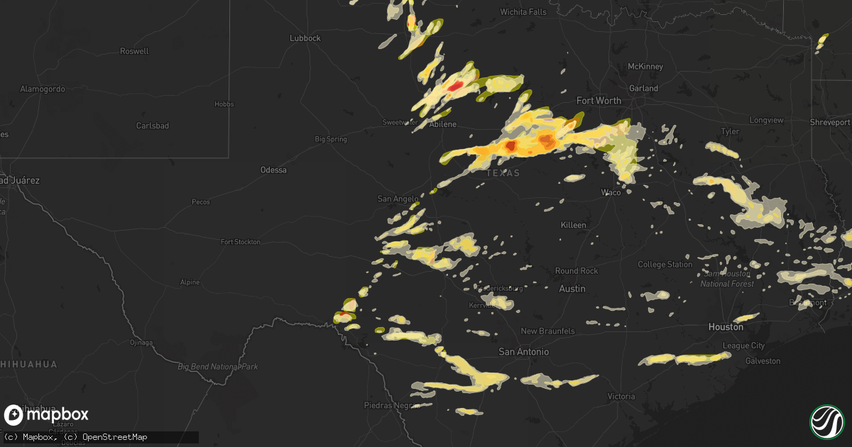
Hail Map in Texas on April 26, 2015
Get this storm
April 26 map
$229
one time, instant access
Download today. No call, no setup
Keep the $229
Bought the map and want the full workflow? Apply the entire $229 to a subscription within 7 days. None of it is wasted.
Every map, not just this one
This buys you this map. Subscription and you get every map we run, in the markets you choose from a few cities to whole states to nationwide. Plus real-time alerts the moment a storm fires.
Contact data
Name, contact info, occupancy, even credit band for addresses in the footprint. You go from where it hit to who to call.
Become the source they trust
Unlimited branding weather history reports on demand. You already have the documented answer ready for the property owner, and you are the one who showed up with it.
Property data and RoofTrace estimates
Pull up any address you have got, its value and the exact code rules for that jurisdiction, straight from One Click Code. Then RoofTrace estimates the squares, pitch, and roof value, priced the way you price.
Storm reports in Texas
Texas
| Date | Description |
|---|---|
| 04/26/20156:55 PM CDT | A local report indicates 1.00 inch wind near 10 NNE ABILENE |
| 04/26/20156:54 PM CDT | A local report indicates 1.00 inch wind near 3 SE WOODSON |
| 04/26/20156:54 PM CDT | Near lake fort phantom hill |
| 04/26/20156:47 PM CDT | A local report indicates 4.25 inch wind near 5 NE STEPHENVILLE |
| 04/26/20156:47 PM CDT | A local report indicates 4.25 inch wind near 5 NE SELDEN |
| 04/26/20156:36 PM CDT | In town |
| 04/26/20156:32 PM CDT | A local report indicates 1.00 inch wind near 3 N FORT GRIFFIN |
| 04/26/20156:24 PM CDT | Trees and powerlines downed in damon. |
| 04/26/20156:07 PM CDT | A local report indicates 1.00 inch wind near MERKEL |
| 04/26/20156:05 PM CDT | Pea to quarter size hail covered intersection of fm 293 and fm 2373 |
| 04/26/20155:51 PM CDT | A local report indicates 1.75 inch wind near GORMAN |
| 04/26/20155:45 PM CDT | A local report indicates 1.75 inch wind near NNE LUEDERS |
| 04/26/20155:45 PM CDT | A local report indicates 1.00 inch wind near 4 S PANTEX |
| 04/26/20155:38 PM CDT | Brief tornado |
| 04/26/20155:36 PM CDT | A few quarters... Mostly pea sized hail covering ground. |
| 04/26/20155:29 PM CDT | A local report indicates 1.25 inch wind near 4 E MASTERSON |
| 04/26/20155:27 PM CDT | A local report indicates 1.00 inch wind near 2 N STAMFORD |
| 04/26/20155:25 PM CDT | Estimated 70 mph winds reported at junction of fm 96 and fm 961. |
| 04/26/20155:24 PM CDT | Hail around 2 inches deep on hwy 6 at eastland/erath county line. |
| 04/26/20155:24 PM CDT | Hail 2 inches deep on hwy 6 at comanche/erath county line. |
| 04/26/20155:21 PM CDT | A local report indicates 1.75 inch wind near PANTEX |
| 04/26/20155:19 PM CDT | A local report indicates 1.00 inch wind near 9 N PADUCAH |
| 04/26/20155:18 PM CDT | A local report indicates 1.00 inch wind near RULE |
| 04/26/20155:17 PM CDT | A local report indicates 1.75 inch wind near PANTEX |
| 04/26/20155:16 PM CDT | A local report indicates 1.00 inch wind near 1 NW RULE |
| 04/26/20155:12 PM CDT | In rising star |
| 04/26/20155:07 PM CDT | A local report indicates 1.00 inch wind near ANSON |
| 04/26/20154:53 PM CDT | A local report indicates 1.50 inch wind near SAGERTON |
| 04/26/20154:44 PM CDT | Spotter reports golf ball hail covering the road 1 south of dublin. |
| 04/26/20154:41 PM CDT | Spotter report of baseball hail 2 east of dublin. |
| 04/26/20154:31 PM CDT | A local report indicates 1.00 inch wind near 1 N PROCTOR |
| 04/26/20154:30 PM CDT | Spotter reports tornado 3sw of dublin. |
| 04/26/20154:30 PM CDT | A local report indicates 60 MPH wind near 2 N PROCTOR |
| 04/26/20154:28 PM CDT | A local report indicates 1.00 inch wind near 11 SSE HASKELL |
| 04/26/20154:22 PM CDT | Pea to quarter size hail. Time estimated by radar. |
| 04/26/20154:19 PM CDT | A local report indicates 1.00 inch wind near 2 E STAMFORD |
| 04/26/20154:15 PM CDT | Tornado on ground 12n of gustine. |
| 04/26/20154:15 PM CDT | A local report indicates 1.00 inch wind near HASKELL |
| 04/26/20154:05 PM CDT | A local report indicates 1.00 inch wind near 11 SE HASKELL |
| 04/26/20154:02 PM CDT | A local report indicates 2.75 inch wind near 7 W DE LEON |
| 04/26/20154:00 PM CDT | Smashed wind |
| 04/26/20153:44 PM CDT | Golf ball hail reported at the us 277/us 83 intersection. |
| 04/26/20153:35 PM CDT | A local report indicates 2.00 inch wind near AVOCA |
| 04/26/20153:33 PM CDT | Spotter 3se of rising star reported tornado w/debris to the south in comanche county. |
| 04/26/20153:28 PM CDT | A local report indicates a tornado near 4 NW SIDNEY |
| 04/26/20153:24 PM CDT | Video of a tornado 3 miles north of may via social media. |
| 04/26/20153:20 PM CDT | A local report indicates 1.00 inch wind near 11 NW VERNON |
| 04/26/20153:17 PM CDT | A local report indicates 1.75 inch wind near 6 N MAY |
| 04/26/20153:16 PM CDT | A local report indicates 1.50 inch wind near AVOCA |
| 04/26/20153:15 PM CDT | A local report indicates 4.50 inch wind near 10 NE LUEDERS |
| 04/26/20153:13 PM CDT | Resident reports tornado on the ground...and it has been observed for the last 10 minutes. |
| 04/26/20153:01 PM CDT | A local report indicates 4.50 inch wind near 11 NNE LUEDERS |
| 04/26/20153:00 PM CDT | A local report indicates 2.50 inch wind near CROSS CUT |
| 04/26/20152:56 PM CDT | A local report indicates 2.75 inch wind near 5 S CROSS PLAINS |
| 04/26/20152:51 PM CDT | Dps abilene reports tornado on the ground just north of burkett. |
| 04/26/20152:45 PM CDT | A local report indicates 1.50 inch wind near LUEDERS |
| 04/26/20152:42 PM CDT | A local report indicates a tornado near 3 N CROSS CUT |
| 04/26/20152:33 PM CDT | A local report indicates 1.00 inch wind near 3 W WEINERT |
| 04/26/20152:27 PM CDT | A local report indicates 1.00 inch wind near 7 NE SILVER VALLEY |
| 04/26/20151:58 PM CDT | A local report indicates 1.00 inch wind near ANSON |
| 04/26/20156:50 AM CDT | Power is out 11 miles nw of lufkin. 3.58 inches of rain in 24 hours. |
| 04/26/20156:39 AM CDT | Trees down at the intersection of 353 and 147. |
| 04/26/20156:39 AM CDT | A local report indicates 1.00 inch wind near BEAUMONT |
| 04/26/20156:21 AM CDT | Trees and power lines donw. |
| 04/26/20156:15 AM CDT | Sheriffs dept reports numerous trees down and power outages county wide. |
| 04/26/20156:14 AM CDT | Sheriffs dept reports tree down across fm1131 and tree down on house. |
| 04/26/20156:09 AM CDT | Public posted photos of trees down and large branches which damaged a car |
| 04/26/20156:05 AM CDT | Power outage in pineland. |
| 04/26/20156:01 AM CDT | A local report indicates 1.00 inch wind near 5 N SILSBEE |
| 04/26/20156:00 AM CDT | Media posted photo of tree uprooted in beaumont |
| 04/26/20156:00 AM CDT | Tornado snapped several trees for 3.6 miles. Most of the property damage was due to falling trees on homes... Sheds and vehicles along the path. For more information see (lch |
| 04/26/20155:59 AM CDT | Trees down at the intersection of 353 and 147. |
| 04/26/20155:47 AM CDT | Sheriffs dept reports trees down from woodville northwest along rte 287. |
| 04/26/20155:41 AM CDT | Trees down along county road 332. |
| 04/26/20155:32 AM CDT | Sheriffs dept reports numerous trees down county wide. |
| 04/26/20155:32 AM CDT | Sheriffs dept reports numerous trees down on powerlines and cars county wide. |
| 04/26/20155:30 AM CDT | Reports of trees down in woden along sr 226. |
| 04/26/20155:24 AM CDT | Reports of trees down in loonyville. |
| 04/26/20155:15 AM CDT | Quarter size hail reported in the beulah community. |
| 04/26/20155:05 AM CDT | Tree down along county road 4248. |
| 04/26/20155:00 AM CDT | Trees and power lines down across san jacinto county |
| 04/26/20155:00 AM CDT | Trees down on hwy 146 s |
| 04/26/20155:00 AM CDT | Trees snapped and uprooted in lilbert. Estimated wind gust to 70 mph. |
| 04/26/20154:58 AM CDT | Trees down across montgomery county |
| 04/26/20154:55 AM CDT | Trees down on fm 350 n |
| 04/26/20154:48 AM CDT | Trees down on fm2025 5 miles south of coldspring. |
| 04/26/20154:46 AM CDT | Trees down |
| 04/26/20154:45 AM CDT | Trees down in point blank along hwy 190. |
| 04/26/20154:45 AM CDT | Trees down on highway 150 southwest of coldspring. |
| 04/26/20154:44 AM CDT | Nws employee reported a large tree down on top of a church along interstate 45 near exit 113 northbound on the south side of huntsville. |
| 04/26/20154:40 AM CDT | Fm241 and hwy 69 closed due to trees and power lines across the road |
| 04/26/20154:40 AM CDT | Numerous trees down across the southern part of cherokee county. |
| 04/26/20154:40 AM CDT | Trees down in new salem near the highway 105 bypass |
| 04/26/20154:40 AM CDT | Trees down around the elkins lake subdivision iin huntsville with roads blocked. Additional roads blocked along hwy 75 in huntsville. |
| 04/26/20154:40 AM CDT | Trees down from elkins lake to new waverly. Trees reported on houses in elkins lake. |
| 04/26/20154:36 AM CDT | Widespread trees down reported on the north side of trinity county... With three quarter inch hail reported from apple spring to groveton |
| 04/26/20154:35 AM CDT | School bus driver reported trees down in nogalus area on fm357. |
| 04/26/20154:35 AM CDT | Measured at kcxo. |
| 04/26/20154:35 AM CDT | A few trees down along hwy 227 and fm 2123 in grapeland. |
| 04/26/20154:35 AM CDT | Trees down in weches |
| 04/26/20154:30 AM CDT | Kprc media team reported 35 oak trees down along winged foot drive in panorama village with some home damage. |
| 04/26/20154:25 AM CDT | Sign damage at gas station along hwy 90 in roans prairie. Trees also reported down. |
| 04/26/20154:11 AM CDT | Straight line winds associated with a weak bookend vortex resulted in a concentrated area of damage to hardwood and softwood trees that were uprooted and had their trun |
| 04/26/20154:10 AM CDT | Damage near and east of anderson was due to straight line winds. |
| 04/26/20154:09 AM CDT | Tornado reported east of anderson... 2 residences hit. Unknown if any injuries occurred. |
| 04/26/20154:00 AM CDT | 3 trees down on the east side of navasota along washington avenue. |
| 04/26/20153:55 AM CDT | Trees down along highway 6 and in hempstead. |
| 04/26/20153:40 AM CDT | Trees down in brenham. |
| 04/26/20153:40 AM CDT | Thunderstorm wind gusts of over 50 mph caused tree damage. Downed 4 inch diameter tree limbs. |
| 04/26/20153:35 AM CDT | Trees down in the town of industry. |
| 04/26/20153:35 AM CDT | Trees down |
| 04/26/20153:25 AM CDT | A local report indicates 1.25 inch wind near 2 S BULLARD |
| 04/26/20153:20 AM CDT | Smith county sheriff is reporting a tree fell through a roof along treasure cove. |
| 04/26/20153:15 AM CDT | Large e2.0 foot trunk diameter oak tree blown down |
| 04/26/20153:00 AM CDT | Quarter size hail or larger |
| 04/26/20152:43 AM CDT | Several reports of trees down in smithville. Time estimated from radar |
| 04/26/20152:02 AM CDT | Tree down on powerline. Time estimated from radar. |
| 04/26/20151:58 AM CDT | Large tree limb down blocking one lane of traffic on rio grande street near 26th street. |
| 04/26/20151:57 AM CDT | Large tree limb on vehicle at 31 and a half street and king street |
| 04/26/20151:55 AM CDT | Reported by former nws employee. Time estimated from radar. |
| 04/26/20151:40 AM CDT | Several 4 inch diameter tree limbs were blown down. Reported by former nws employee. Time estimated from radar. |
| 04/26/20151:33 AM CDT | Tree down blocking roadway near intersection of westgate blvd and cohoba dr. Time estimated from radar |
| 04/26/20151:20 AM CDT | Trees down on power lines near intersection of hwy 90 and general mcmullen |
| 04/26/20151:05 AM CDT | Overturned tractor trailer i-35e northbound between mile markers 7 & 8. Dps on location. Time estimated by spotter. |
| 04/26/201512:40 AM CDT | A local report indicates 1.00 inch wind near HUBBARD |
| 04/25/201511:50 PM CDT | Large tree blown down in yard |
| 04/25/201511:49 PM CDT | A local report indicates 1.00 inch wind near MIDLOTHIAN |
| 04/25/201511:24 PM CDT | A local report indicates a tornado near 4 S BLUM |
| 04/25/201511:17 PM CDT | Trees and limbs down in mason. Some carports also damaged in town. |
| 04/25/201511:14 PM CDT | An nws survey team found evidence of damage consistent with winds up to 105 mph. |
| 04/25/201511:10 PM CDT | Powerlines down on train tracks. Time estimated from radar |
| 04/25/201510:53 PM CDT | A local report indicates 60 MPH wind near RIO VISTA |
| 04/25/201510:50 PM CDT | A local report indicates a tornado near 1 NNW RIO VISTA |
| 04/25/201510:48 PM CDT | A local report indicates a tornado near 3 N COVINGTON |
| 04/25/201510:37 PM CDT | A local report indicates 1.75 inch wind near GLEN ROSE |
| 04/25/201510:32 PM CDT | A local report indicates 1.75 inch wind near CLEBURNE |
| 04/25/201510:30 PM CDT | A local report indicates 1.00 inch wind near 6 ESE CLEBURNE |
| 04/25/201510:24 PM CDT | A local report indicates a tornado near 6 W RIO VISTA |
| 04/25/201510:20 PM CDT | 100 trees knocked down... Some as big as 3-4 feet in diameter... Tore roof off of shed |
| 04/25/201510:13 PM CDT | A local report indicates a tornado near RIO VISTA |
| 04/25/201510:13 PM CDT | A local report indicates a tornado near 3 W GLEN ROSE |
| 04/25/201510:08 PM CDT | A local report indicates 1.00 inch wind near PALUXY |
| 04/25/201510:00 PM CDT | Trees and power lines were blown down. Also...several barns...boat docks...and one boat damaged. |
| 04/25/201510:00 PM CDT | A tornado touched down at 1000 pm 2 miles wnw of lake brownwood state park. This tornado traveled east...lifting at 1005 pm 1 mile wnw of the state park. An nws storm s |
| 04/25/20159:40 PM CDT | A local report indicates 1.00 inch wind near 6 S FORT MCKAVETT |
| 04/25/20159:39 PM CDT | A local report indicates 1.00 inch wind near 2 S JUNO |
| 04/25/20159:33 PM CDT | Large trees down near brazos point |
| 04/25/20159:30 PM CDT | Trees and power lines were blown down. Also...one boat was damaged. |
| 04/25/20159:29 PM CDT | A local report indicates 2.50 inch wind near 6 ENE GLEN ROSE |
| 04/25/20159:27 PM CDT | A local report indicates 1.00 inch wind near 5 ESE BURKETT |
| 04/25/20159:27 PM CDT | Large tornado on the ground between brazos point and eulogy |
| 04/25/20159:25 PM CDT | Quarter size hail on us 87. |
| 04/25/20159:16 PM CDT | A local report indicates 1.00 inch wind near 1 NNW SONORA |
| 04/25/20159:09 PM CDT | Tornado on 144 3 miles south of glen rose |
| 04/25/20158:48 PM CDT | A local report indicates 1.00 inch wind near ELDORADO |
| 04/25/20158:18 PM CDT | A local report indicates 1.75 inch wind near STRAWN |
| 04/25/20158:14 PM CDT | Between clariette and duffau. |
| 04/25/20158:04 PM CDT | A local report indicates 2.75 inch wind near 7 SE STEPHENVILLE |
| 04/25/20157:49 PM CDT | Marble to golf ball size |
| 04/25/20157:42 PM CDT | A local report indicates 3.00 inch wind near 1 SW DUBLIN |
| 04/25/20157:25 PM CDT | A local report indicates 1.75 inch wind near DUBLIN |
| 04/25/20157:10 PM CDT | A local report indicates 1.00 inch wind near 9 W ELDORADO |
| 04/25/20157:04 PM CDT | Large cone |
| 04/25/20157:03 PM CDT | A local report indicates a tornado near 5 E STEPHENVILLE |
Cities Impacted by Hail Map on April 26, 2015
- Poteet, TX
- Vancourt, TX
- Kennard, TX
- Grapeland, TX
- Groveton, TX
- Alto, TX
- Elkhart, TX
- Palestine, TX
- Crockett, TX
- Wells, TX
- Pollok, TX
- Lufkin, TX
- Apple Springs, TX
- Rusk, TX
- Tolar, TX
- Corsicana, TX
- Channing, TX
- Haskell, TX
- Lakeview, TX
- Childress, TX
- Cleburne, TX
- Carbon, TX
- Rising Star, TX
- Kemp, TX
- Texarkana, AR
- Silsbee, TX
- Buna, TX
- Kountze, TX
- Quanah, TX
- Sabinal, TX
- Knippa, TX
- Diboll, TX
- Huntington, TX
- Oakwood, TX
- Pennington, TX
- Alvarado, TX
- Warren, TX
- Fred, TX
- Weinert, TX
- Leesville, LA
- Fort Polk, LA
- Avoca, TX
- Sylvester, TX
- Albany, TX
- Stamford, TX
- Sweetwater, TX
- Lueders, TX
- Anson, TX
- Throckmorton, TX
- Merkel, TX
- Hawley, TX
- Abilene, TX
- Midlothian, TX
- Dublin, TX
- Clyde, TX
- Coleman, TX
- Strawn, TX
- Menard, TX
- Junction, TX
- Grandview, TX
- Rio Vista, TX
- Llano, TX
- Valley Spring, TX
- Cherokee, TX
- Covington, TX
- Blum, TX
- Voss, TX
- Ballinger, TX
- Talpa, TX
- Woodson, TX
- Gordon, TX
- Uvalde, TX
- Eldorado, TX
- South Bend, TX
- Breckenridge, TX
- Graham, TX
- Bluff Dale, TX
- Cross Plains, TX
- Burkett, TX
- Comanche, TX
- Desdemona, TX
- Hico, TX
- De Leon, TX
- Gorman, TX
- Brownwood, TX
- Stephenville, TX
- Kerens, TX
- Rice, TX
- Call, TX
- Floydada, TX
- Midway, TX
- Goodrich, TX
- Shepherd, TX
- Old Glory, TX
- Paducah, TX
- Granbury, TX
- Malone, TX
- Milford, TX
- Frost, TX
- Blooming Grove, TX
- Hubbard, TX
- Penelope, TX
- Hillsboro, TX
- West, TX
- Mertens, TX
- Abbott, TX
- Italy, TX
- Mount Calm, TX
- Bynum, TX
- Axtell, TX
- Cotulla, TX
- Crystal City, TX
- Eagle Pass, TX
- Mason, TX
- Paint Rock, TX
- Eden, TX
- Christoval, TX
- San Angelo, TX
- Aspermont, TX
- Rule, TX
- Montgomery, TX
- Dripping Springs, TX
- Ranger, TX
- Caddo, TX
- Nash, OK
- Cleveland, TX
- Poth, TX
- Falls City, TX
- Hobson, TX
- Yorktown, TX
- Nordheim, TX
- Cuero, TX
- Floresville, TX
- Karnes City, TX
- Gillett, TX
- Runge, TX
- Pleasanton, TX
- London, TX
- Brady, TX
- Sonora, TX
- Hext, TX
- Rosharon, TX
- Fairfield, TX
- Bastrop, TX
- Hebbronville, TX
- Zavalla, TX
- Comstock, TX
- Rochester, TX
- Jacksonville, TX
- Bullard, TX
- Frankston, TX
- Flint, TX
- Larue, TX
- Dawson, TX
- Franklin, TX
- Rocksprings, TX
- Needville, TX
- Boling, TX
- Lampasas, TX
- Gatesville, TX
- Batesville, TX
- La Pryor, TX
- Waxahachie, TX
- San Saba, TX
- Pontotoc, TX
- Deridder, LA
- Mingus, TX
- Devine, TX
- Moore, TX
- Del Rio, TX
- Panhandle, TX
- Amarillo, TX
- Pearsall, TX
- Knox City, TX
- O'Brien, TX
- Highlands, TX
- Dayton, TX
- Baytown, TX
- Crosby, TX
- Houston, TX
- Dalhart, TX
- Trinity, TX
- Rainbow, TX
- Glen Rose, TX
- Nemo, TX
- Kopperl, TX
- Concan, TX
- Brackettville, TX
- Rio Frio, TX
- Barksdale, TX
- Camp Wood, TX
- Colmesneil, TX
- Broaddus, TX
- Brookeland, TX
- Jasper, TX
- Kirbyville, TX
- Dickens, TX
- Kerrville, TX
- Fredericksburg, TX
- Schulenburg, TX
- Big Wells, TX
- Nolan, TX
- Woodville, TX
- Chandler, TX
- Troup, TX
- Seymour, TX
- Bigfoot, TX
- Dumas, TX
- Chatfield, TX
- Maypearl, TX
- Venus, TX
- Keene, TX
- Eastland, TX
- Walnut Springs, TX
- Lipan, TX
- Sidney, TX
- May, TX
- Novice, TX
- Winters, TX
- Goldsboro, TX
- Santo, TX
- Godley, TX
- Laredo, TX
- Boerne, TX
- Comfort, TX
- Cranfills Gap, TX
- Clifton, TX
- Jonesboro, TX
- Yancey, TX
- D Hanis, TX
- Willis, TX
- New Waverly, TX
- Masterson, TX
- Lumberton, TX
- Beaumont, TX
- Mart, TX
- Blanket, TX
- Hallettsville, TX
- Wharton, TX
- East Bernard, TX
- Louise, TX
- Guy, TX
- Glen Flora, TX
- Garwood, TX
- El Campo, TX
- Alvin, TX
- Manvel, TX
- Eagle Lake, TX
- Edna, TX
- Damon, TX
- Briggs, TX
- Harper, TX
- Gracemont, OK
- Binger, OK
- Liberty, TX
- Castell, TX
- Groesbeck, TX
- Crowell, TX
- Corrigan, TX
- Natalia, TX
- Quemado, TX
- Dequincy, LA
- Center Point, TX
- Hedley, TX
- Turkey, TX
- Graford, TX
- Deweyville, TX
- Vidor, TX
- Orange, TX
- Medina, TX
- Tarpley, TX
- Newton, TX
- Burkeville, TX
- Mountain Home, TX
- Fort Cobb, OK
- Livingston, TX
- Muldoon, TX
- Flatonia, TX
- Iredell, TX
- Wiergate, TX
- Waelder, TX
- Art, TX
- Wortham, TX
- Lovelady, TX
- Munday, TX
- Merryville, LA
- Memphis, TX
- Evans, LA
- Rosepine, LA
- Santa Anna, TX
- Longville, LA
- Singer, LA
- Bandera, TX
- Douglass, TX
- Nacogdoches, TX
- Chireno, TX
- Etoile, TX
- Spur, TX
- Johnson City, TX
- Mcalester, OK
- Huntsville, TX
- Aquilla, TX
- Elm Mott, TX
- Waco, TX
- Holland, TX
- Bangs, TX
- Coldspring, TX
- Powell, TX
- Mabank, TX
- Thornton, TX
- Brenham, TX
- Chappell Hill, TX
- Clarendon, TX
- Trinidad, TX
- Malakoff, TX
- Centerville, TX
- Plantersville, TX
- Bedias, TX
- Coolidge, TX
- Itasca, TX
- Prairie Hill, TX
- Kendalia, TX
- Fouke, AR
- Scurry, TX
- Hempstead, TX
- Smithville, TX
- La Grange, TX
- Spurger, TX
- Streetman, TX
- Marquez, TX
- Jewett, TX
- Sulphur, LA
- Whitney, TX
- Forreston, TX
- Cisco, TX
- Palmer, TX
- Baird, TX
- Barry, TX
- Ennis, TX
- Purdon, TX
- Morgan, TX
- Valera, TX
- Hull, TX
- New Ulm, TX
- Industry, TX
- Pipe Creek, TX
- Moscow, TX
- Chester, TX
- Marble Falls, TX
- Horseshoe Bay, TX
- Dale, TX
- Rosanky, TX
- Harwood, TX
- Trent, TX
- Buffalo, TX
- Lometa, TX
- Matador, TX
- Eola, TX
- Wall, TX
- Leakey, TX
- Bon Wier, TX
- Hamlin, TX
- Starks, LA
- Vinton, LA
- Woodway, TX
- Weatherford, TX
- Poolville, TX
- Carmine, TX
- Burton, TX
- Bridgeport, TX
- Eldorado, OK
- Gould, OK
- Meridian, TX
- Stonewall, TX
- Oakhurst, TX
- Saratoga, TX
- Alvord, TX
- Giddings, TX
- Bellville, TX
- Wakita, OK
- Valley Mills, TX
- Mexia, TX
- Fulton, AR
- Claude, TX
- Groom, TX
- Roosevelt, OK
- Fort McKavett, TX
- Mereta, TX
- Rowena, TX
- Newcastle, TX
- Cresson, TX
- Palo Pinto, TX
- Mineral Wells, TX
- McCaulley, TX
- Red Oak, TX
- Fort Worth, TX


