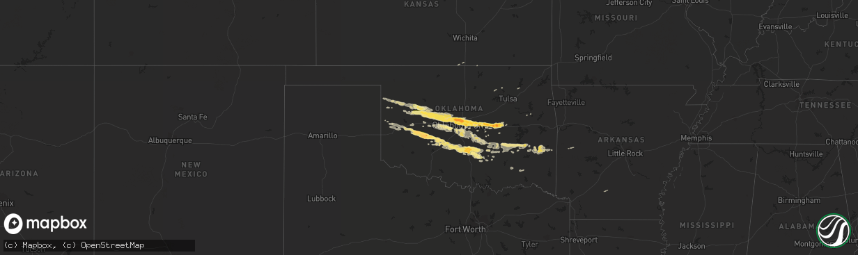
Hail Map in Oklahoma on April 26, 2013
The weather event in Oklahoma on April 26, 2013 includes Hail map. 3 states and 139 cities were impacted and suffered possible damage. The total estimated number of properties impacted is 132,267.
Want more than just the map?
Turn this storm into a full workflow.
- Owner + property data so you know who to knock
- OnDemand branded weather history reports to win the "did we even have hail?" argument
- RoofTrace estimate so reps stop guessing numbers at the door
Bought this map? Upgrade within 7 days and we'll credit the $230. (10-15 min setup call)
Hail
132,267
Estimated number of impacted properties by a 1.00" hail or larger94,369
Estimated number of impacted properties by a 1.75" hail or larger0
Estimated number of impacted properties by a 2.50" hail or largerStorm reports in Oklahoma
Oklahoma
| Date | Description |
|---|---|
| 04/26/20136:49 PM CDT | A local report indicates 1.25 inch wind near 10 E SWEETWATER |
| 04/26/20136:40 PM CDT | A local report indicates 60 MPH wind near 2 S PUTNAM |
| 04/26/20136:31 PM CDT | A brief tornado was observed. |
| 04/26/20136:05 PM CDT | A local report indicates 64 MPH wind near 4 WNW CAMARGO |
| 04/26/20135:22 PM CDT | A local report indicates 1.00 inch wind near 3 NE ARNETT |
| 04/26/20133:40 PM CDT | Cold air funnel briefly touched down. |
| 04/26/201312:40 AM CDT | A local report indicates 1.00 inch wind near 2 W ROFF |
| 04/26/201312:30 AM CDT | A local report indicates 1.00 inch wind near 7 WNW ROFF |
| 04/26/201312:05 AM CDT | A local report indicates 1.25 inch wind near PAULS VALLEY |
| 04/26/201312:00 AM CDT | A local report indicates 1.75 inch wind near 2 NNE PAULS VALLEY |
| 04/25/201311:56 PM CDT | A local report indicates 1.00 inch wind near ADA |
| 04/25/201311:48 PM CDT | A local report indicates 1.00 inch wind near 2 S STRATFORD |
| 04/25/201311:45 PM CDT | 9 inch tree limb on roadway. Power lines across highway 19. |
| 04/25/201311:42 PM CDT | A local report indicates 1.00 inch wind near MAYSVILLE |
| 04/25/201311:15 PM CDT | Large tree limbs down. |
| 04/25/201311:04 PM CDT | A local report indicates 1.00 inch wind near 10 W HENRYETTA |
| 04/25/201310:40 PM CDT | 20 inch diameter tree down across e1120 road southeast of okemah. |
| 04/25/201310:38 PM CDT | On highway 62 about 3 miles west of okemah. Hail was about 3 inches deep in some spots on the road. |
| 04/25/201310:37 PM CDT | Wind gust of 59 mph also reported. |
| 04/25/201310:17 PM CDT | A local report indicates 1.25 inch wind near 1 SSE STANLEY DRAPER LA |
| 04/25/201310:06 PM CDT | A local report indicates 1.75 inch wind near PRAGUE |
| 04/25/201310:05 PM CDT | Nickel to quarter size hail covering the ground. Up to 3 inches deep in some locations. |
| 04/25/201310:04 PM CDT | Also ping pong sized hail. Windows broke out of houses. |
| 04/25/201310:00 PM CDT | A local report indicates 1.75 inch wind near PRAGUE |
| 04/25/20139:50 PM CDT | A local report indicates 1.00 inch wind near MUSTANG |
| 04/25/20139:45 PM CDT | A local report indicates 1.25 inch wind near CHICKASHA |
| 04/25/20139:44 PM CDT | A local report indicates 1.00 inch wind near 1 W MUSTANG |
| 04/25/20139:41 PM CDT | A local report indicates 1.00 inch wind near CHICKASHA |
| 04/25/20139:38 PM CDT | A local report indicates 1.50 inch wind near 6 W MEEKER |
| 04/25/20139:32 PM CDT | A local report indicates 61 MPH wind near CYRIL |
| 04/25/20139:30 PM CDT | A local report indicates 1.75 inch wind near 3 E ANADARKO |
| 04/25/20139:20 PM CDT | A local report indicates 1.00 inch wind near 2 N ANADARKO |
| 04/25/20139:18 PM CDT | A local report indicates 1.25 inch wind near CHOCTAW |
| 04/25/20139:15 PM CDT | A local report indicates 1.00 inch wind near JONES |
| 04/25/20139:15 PM CDT | *** 1 inj *** nws storm survey indicated damage consistent with rfd winds of 70 to 80 mph. Heavy roof damage to two homes and a church. Also trees and light poles down. |
| 04/25/20139:14 PM CDT | A local report indicates 1.75 inch wind near CHOCTAW |
| 04/25/20139:05 PM CDT | A local report indicates 1.50 inch wind near FORT COBB |
| 04/25/20138:57 PM CDT | A local report indicates 1.00 inch wind near 2 E HINTON |
| 04/25/20138:50 PM CDT | A local report indicates 1.50 inch wind near 6 N NICHOLS HILLS |
| 04/25/20138:50 PM CDT | A local report indicates 2.50 inch wind near EDMOND |
| 04/25/20138:48 PM CDT | A local report indicates 1.75 inch wind near 2 S ALFALFA |
| 04/25/20138:48 PM CDT | A local report indicates 1.75 inch wind near 5 NW OKLAHOMA CITY |
| 04/25/20138:46 PM CDT | A local report indicates 1.25 inch wind near 7 NW OKLAHOMA CITY |
| 04/25/20138:45 PM CDT | A local report indicates 60 MPH wind near 5 SSE PIEDMONT |
| 04/25/20138:45 PM CDT | A local report indicates 1.50 inch wind near EDMOND |
| 04/25/20138:43 PM CDT | A local report indicates 2.00 inch wind near 4 NW THE VILLAGE |
| 04/25/20138:42 PM CDT | A local report indicates 1.25 inch wind near 3 NNW BETHANY |
| 04/25/20138:41 PM CDT | A local report indicates 1.50 inch wind near ALFALFA |
| 04/25/20138:40 PM CDT | A local report indicates 1.50 inch wind near 10 NNE OKLAHOMA CITY |
| 04/25/20138:38 PM CDT | A local report indicates 2.00 inch wind near 1 S ALFALFA |
| 04/25/20138:38 PM CDT | 1 s alfalfa ok. Time of hail fall estimated. Found almost 2 inch diameter hail stones on ground about one half hour after the hail fell. |
| 04/25/20138:37 PM CDT | A local report indicates 1.25 inch wind near 4 NNW BETHANY |
| 04/25/20138:34 PM CDT | A local report indicates 1.25 inch wind near 5 SSE PIEDMONT |
| 04/25/20138:32 PM CDT | A local report indicates 1.75 inch wind near 1 N COWDEN |
| 04/25/20138:19 PM CDT | A local report indicates 2.00 inch wind near 3 N CLOUD CHIEF |
| 04/25/20138:18 PM CDT | Also quarter to half dollar size hail. |
| 04/25/20138:15 PM CDT | A local report indicates 60 MPH wind near CONCHO |
| 04/25/20138:15 PM CDT | A local report indicates 1.25 inch wind near CONCHO |
| 04/25/20137:43 PM CDT | A local report indicates 1.00 inch wind near GREENFIELD |
| 04/25/20137:10 PM CDT | Also received nickel size hail |
| 04/25/20137:09 PM CDT | A local report indicates 1.00 inch wind near OAKWOOD |
Cities Impacted by Hail Map on April 26, 2013
- Calvin, OK
- Atwood, OK
- Atoka, OK
- Stringtown, OK
- Cordell, OK
- Anadarko, OK
- Leedey, OK
- Hinton, OK
- Choctaw, OK
- Arnett, OK
- Prague, OK
- Greenfield, OK
- Geary, OK
- Spencer, OK
- Fay, OK
- Putnam, OK
- Thomas, OK
- Canton, OK
- Paden, OK
- Okarche, OK
- Weleetka, OK
- Shawnee, OK
- Okemah, OK
- Bethany, OK
- Seiling, OK
- Camargo, OK
- Yukon, OK
- Mcloud, OK
- Kingfisher, OK
- El Reno, OK
- Boley, OK
- Meeker, OK
- Vici, OK
- Watonga, OK
- Oklahoma City, OK
- Jones, OK
- Arcadia, OK
- Castle, OK
- Luther, OK
- Oakwood, OK
- Custer City, OK
- Taloga, OK
- Harrah, OK
- Piedmont, OK
- Edmond, OK
- Calumet, OK
- Wellston, OK
- Stratford, OK
- Waldron, AR
- Carnegie, OK
- Talihina, OK
- Wister, OK
- Heavener, OK
- Butler, OK
- Cashion, OK
- Sparks, OK
- Hartshorne, OK
- Wilburton, OK
- Pauls Valley, OK
- Wayne, OK
- Byars, OK
- Paoli, OK
- Verden, OK
- Chickasha, OK
- Gracemont, OK
- Konawa, OK
- Newalla, OK
- Asher, OK
- Tecumseh, OK
- Maud, OK
- Macomb, OK
- Wanette, OK
- Norman, OK
- Newcastle, OK
- Hodgen, OK
- Fort Cobb, OK
- Blanco, OK
- Kiowa, OK
- Mcalester, OK
- Sulphur, OK
- Wynnewood, OK
- Lindsay, OK
- Maysville, OK
- Bradley, OK
- Ninnekah, OK
- Alex, OK
- Foss, OK
- Canute, OK
- South Haven, KS
- Union City, OK
- Mustang, OK
- Minco, OK
- Purcell, OK
- Rush Springs, OK
- Blanchard, OK
- Hydro, OK
- Weatherford, OK
- Cement, OK
- Bessie, OK
- Corn, OK
- Stuart, OK
- Krebs, OK
- Red Oak, OK
- Cheyenne, OK
- Elk City, OK
- Sayre, OK
- Seminole, OK
- Noble, OK
- Roff, OK
- Sasakwa, OK
- Holdenville, OK
- Allen, OK
- Wewoka, OK
- Ada, OK
- Muskogee, OK
- Camden, AR
- Henryetta, OK
- Centrahoma, OK
- Coalgate, OK
- Rattan, OK
- Finley, OK
- Antlers, OK
- Elmore City, OK
- Apache, OK
- Davis, OK
- Fitzhugh, OK
- Wetumka, OK
- Claremore, OK
- Newkirk, OK
- Hominy, OK
- Clinton, OK
- Tuttle, OK
- Skiatook, OK
- Fort Gibson, OK
- Stonewall, OK
- Caldwell, KS
- Chidester, AR
- Tupelo, OK
- Colony, OK


