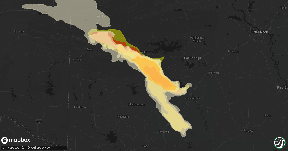
Hail Map in Glenwood, AR on April 25, 2026
Get this storm
April 25 map
$229
one time, instant access
Download today. No call, no setup
Keep the $229
Bought the map and want the full workflow? Apply the entire $229 to a subscription within 7 days. None of it is wasted.
Every map, not just this one
This buys you this map. Subscription and you get every map we run, in the markets you choose from a few cities to whole states to nationwide. Plus real-time alerts the moment a storm fires.
Contact data
Name, contact info, occupancy, even credit band for addresses in the footprint. You go from where it hit to who to call.
Become the source they trust
Unlimited branding weather history reports on demand. You already have the documented answer ready for the property owner, and you are the one who showed up with it.
Property data and RoofTrace estimates
Pull up any address you have got, its value and the exact code rules for that jurisdiction, straight from One Click Code. Then RoofTrace estimates the squares, pitch, and roof value, priced the way you price.
Storm reports in Glenwood, AR
Glenwood, AR
| Date | Description |
|---|---|
| 04/24/20269:05 PM CDT | Montgomery co sheriff deputy reported baseball sized hail between glenwood and bonnerdale on us70 in southeast montgomery co. Time and location estimated from radar. |
| 04/24/20269:05 PM CDT | Ham radio operator reports between golf ball to baseball sized hail in glenwood. Time estimated from radar. |
| 04/24/20269:05 PM CDT | Updates previous hail report from welsh. Montgomery co sheriff dept report damaged windshields to patrol cars... And damage to roofs from the public. Montgomery co sher |
| 04/24/20269:05 PM CDT | Pike co. Em reports tree and powerline damage near baker and bethel roads. Time estimated from radar. |
| 04/24/20269:05 PM CDT | Numerous trees uprooted in the area. |
| 04/24/20269:03 PM CDT | Public report of quarter sized hail just east of glenwood. Time estimated by radar. |
All States Impacted by Hail Map on April 25, 2026
All Cities Impacted by Hail Map on April 25, 2026
- Minden, NE
- Lebanon, KS
- Red Cloud, NE
- Campbell, NE
- Guide Rock, NE
- Blue Hill, NE
- Lawrence, NE
- Hastings, NE
- Glenvil, NE
- Inland, NE
- Trumbull, NE
- Gaylord, KS
- Cedar, KS
- Brownell, KS
- Portis, KS
- McCracken, KS
- Keysville, VA
- Charlotte Court House, VA
- Giltner, NE
- Harvard, NE
- Aurora, NE
- Henderson, NE
- Downs, KS
- La Crosse, KS
- York, NE
- Bradshaw, NE
- Hampton, NE
- Larned, KS
- Esbon, KS
- Benedict, NE
- Alexander, KS
- Rush Center, KS
- Nekoma, KS
- Wister, OK
- Red Oak, OK
- Bison, KS
- Stromsburg, NE
- Gresham, NE
- Waco, NE
- Cawker City, KS
- McCool Junction, NE
- Glen Elder, KS
- Wichita Falls, TX
- Iowa Park, TX
- Fairmont, NE
- Beloit, KS
- Holliday, TX
- Shickley, NE
- Ulysses, NE
- Utica, NE
- Howe, OK
- Sheppard Afb, TX
- Heavener, OK
- Poteau, OK
- Langston, AL
- Keota, OK
- Stigler, OK
- Randall, KS
- Stratford, OK
- Ada, OK
- Macksville, KS
- Delaware, OK
- Seward, NE
- Staplehurst, NE
- Belpre, KS
- Winfield, KS
- Bee, NE
- Cedar Vale, KS
- Rose, OK
- Salina, OK
- Fyffe, AL
- Section, AL
- Sedan, KS
- Geneva, NE
- Strang, NE
- Exeter, NE
- Temple, OK
- Otis, KS
- Garfield, KS
- Beaver Crossing, NE
- Ohiowa, NE
- Bruning, NE
- Burden, KS
- Cambridge, KS
- Jamestown, KS
- Concordia, KS
- Hastings, OK
- Comanche, OK
- Waurika, OK
- Simpson, KS
- Colwich, KS
- Andale, KS
- Lenapah, OK
- Waldron, AR
- Bokoshe, OK
- Goehner, NE
- Pawnee Rock, KS
- Friend, NE
- Cordova, NE
- Wichita, KS
- Vinita, OK
- Maize, KS
- Belvidere, NE
- Mena, AR
- St John, KS
- Byers, KS
- Iuka, KS
- Henrietta, TX
- Scotland, TX
- Duncan, OK
- Bluejacket, OK
- Welch, OK
- Pratt, KS
- Dorchester, NE
- Tobias, NE
- Milligan, NE
- Alexandria, NE
- Milford, NE
- Grenola, KS
- Cameron, OK
- Shady Point, OK
- Longton, KS
- Porum, OK
- Turon, KS
- Cunningham, KS
- Glasco, KS
- Delphos, KS
- Daykin, NE
- Marlow, OK
- Havana, KS
- Afton, OK
- Windthorst, TX
- Rush Springs, OK
- Lindsay, OK
- Foster, OK
- Maysville, OK
- Stonewall, OK
- Aurora, KS
- Boles, AR
- Hartford, AR
- Moline, KS
- Western, NE
- Fairbury, NE
- Garland, NE
- Centre, AL
- Roff, OK
- Elk City, KS
- Independence, KS
- Sawyer, KS
- Isabel, KS
- Miami, OK
- Fairland, OK
- Swanton, NE
- Plymouth, NE
- Peru, KS
- Caney, KS
- Niotaze, KS
- Bellevue, TX
- Fitzhugh, OK
- Allen, OK
- Tupelo, OK
- Parks, AR
- Medicine Lodge, KS
- Jansen, NE
- De Witt, NE
- Wynnewood, OK
- Crete, NE
- Wyandotte, OK
- Mount Hope, KS
- Bowie, TX
- Valley Center, KS
- Goddard, KS
- Nashville, KS
- Centrahoma, OK
- Andover, KS
- Fittstown, OK
- Oden, AR
- Mount Ida, AR
- Pauls Valley, OK
- Grove, OK
- Anderson, MO
- Tiff City, MO
- Goodman, MO
- Seneca, MO
- Miltonvale, KS
- Beatrice, NE
- Coffeyville, KS
- Tishomingo, OK
- Jacksboro, TX
- Dearing, KS
- Elmore City, OK
- South West City, MO
- Spiro, OK
- Zenda, KS
- Coalgate, OK
- Pickrell, NE
- Wilber, NE
- Cortland, NE
- Clatonia, NE
- Lincoln, AR
- Prairie Grove, AR
- Tyro, KS
- Mill Creek, OK
- Hackett, AR
- Mcconnell Afb, KS
- Paoli, OK
- Farmington, AR
- Fayetteville, AR
- West Fork, AR
- Copan, OK
- Clay Center, KS
- Norman, AR
- Bridgeport, TX
- Chico, TX
- Wann, OK
- S Coffeyville, OK
- Derby, KS
- Liberty, KS
- Coats, KS
- Mansfield, AR
- Milburn, OK
- Fort Smith, AR
- Pocola, OK
- Pencil Bluff, AR
- Huntington, AR
- Winslow, AR
- Elkins, AR
- Wapanucka, OK
- Macomb, OK
- Wanette, OK
- Minneapolis, KS
- Byars, OK
- Sunset, TX
- Tecumseh, OK
- Caddo Gap, AR
- Bonnerdale, AR
- Lexington, OK
- Adams, NE
- Firth, NE
- Coleman, OK
- Glenwood, AR
- Paradise, TX
- Alvord, TX
- Atoka, OK
- Kenefic, OK
- Perrin, TX
- Poolville, TX
- Wakefield, KS
- Locust Grove, OK
- Amity, AR
- Colcord, OK
- Boyd, TX
- Ozark, AR
- Combs, AR
- Caddo, OK
- Royal, AR
- Rhome, TX
- Springtown, TX
- Caney, OK
- Hulbert, OK
- Peggs, OK
- Oark, AR
- Pettigrew, AR
- Decatur, TX
- Okemah, OK
- Sulphur, OK
- Azle, TX
- Newark, TX
- Fort Worth, TX
- Weatherford, TX
- Elk Creek, NE
- Tecumseh, NE
- Steinauer, NE
- Tahlequah, OK
- Weleetka, OK
- Muskogee, OK
- Kansas, OK
- Stilwell, OK
- Table Rock, NE
- Proctor, OK
- Clarksville, AR
- Ozone, AR
- Arkadelphia, AR
- Johnson, NE
- Humboldt, NE
- Milford, KS
- Riley, KS
- Bokchito, OK
- Lane, OK
- Bennington, OK
- Kirby, AR
- Lewiston, NE
- Canehill, AR
- Fort Riley, KS
- Delight, AR
- Greenwood, AR
- Okolona, AR
- Bismarck, AR
- Midland, AR
- Aledo, TX
- Boswell, OK
- Newhope, AR
- Nashville, AR
- Naval Air Station Jrb, TX
- Dierks, AR
- Antoine, AR
- Gans, OK
- Ozan, AR
- Leon, OK
- McCaskill, AR
- Mineral Springs, AR
- Gurdon, AR
- Booneville, AR
- Washington, AR
- Columbus, AR
- Hope, AR
- Donaldson, AR
- Hugo, OK
- Muenster, TX
- Saint Jo, TX
- Prescott, AR
- Haltom City, TX
- Emmet, AR
- Bluff City, AR
- Chidester, AR
- Langley, AR
- Umpire, AR
- Arlington, TX
- Kennedale, TX
- Hurst, TX
- North Richland Hills, TX
- Haslet, TX
- Grant, OK
- Rosston, AR
- Murfreesboro, AR
- Soper, OK
- Grand Prairie, TX
- Bedford, TX
- Camden, AR
- Euless, TX
- Buckner, AR
- Arthur City, TX
- Dallas, TX
- Fulton, AR
- Sims, AR
- Story, AR
- Powderly, TX
- Cedar Hill, TX
- Duncanville, TX
- Burneyville, OK
- Desoto, TX
- Stamps, AR
- Lewisville, AR
- Texarkana, AR
- Loco, OK
- Healdton, OK
- Stephens, AR
- Lancaster, TX
- Mount Holly, AR
- Hampton, AR
- Willisville, AR
- Waldo, AR
- Louann, AR
- Smackover, AR
- Magnolia, AR
- Red Oak, TX
- Wilson, OK
- Emerson, AR
- El Dorado, AR
- Gainesville, TX
- Overbrook, OK
- Junction City, AR
- Ferris, TX
- Wilmer, TX
- Marietta, OK
- Lillie, LA
- Summerfield, LA
- Haynesville, LA
- Ringling, OK
- Thackerville, OK
- Strong, AR
- Taylor, AR
- Spearsville, LA
- Graham, OK
- Seagoville, TX
- Kaufman, TX
- Scurry, TX
- Springer, OK
- Ratliff City, OK
- Bernice, LA
- Huttig, AR
- Farmerville, LA
- Marion, LA
- Whitesboro, TX
- Downsville, LA
- Homer, LA
- Sterlington, LA
- Tallulah, LA
- Athens, LA
- Arcadia, LA
- Monroe, LA
- Calhoun, LA
- West Monroe, LA
- Edwards, MS
- Eros, LA
- Simsboro, LA
- Pottsboro, TX
- Rayville, LA
- Dubach, LA
- Sherman, TX
- Ruston, LA
- Denison, TX
- Mangham, LA
- Raymond, MS
- Utica, MS
- Columbia, LA
- Cotton Valley, LA
- Shongaloo, LA
- Minden, LA
- Vicksburg, MS
- Grambling, LA
- Winnsboro, LA
- Ardmore, OK
- Madill, OK
- Baskin, LA
- Yazoo City, MS
- Lockney, TX
- Wisner, LA
- Gilbert, LA
- Colbert, OK
- Lisbon, LA
- Gibsland, LA
- Saint Joseph, LA
- Newellton, LA
- Flora, MS
- Cartwright, OK
- Saint Paul, AR
- Bells, TX
- Port Gibson, MS
- Lorman, MS
- Florence, MS
- Howe, TX
- Fayette, MS
- Natchez, MS
- Whitewright, TX
- Braxton, MS
- Pattison, MS
- Harrisville, MS
- Savoy, TX
- Tom Bean, TX
- Bonham, TX
- Mendenhall, MS
- Trenton, TX
- Randolph, TX
- Leonard, TX
- Van Alstyne, TX
- Ector, TX
- Jefferson, TX
- Dighton, KS
- Celeste, TX
- Mize, MS


