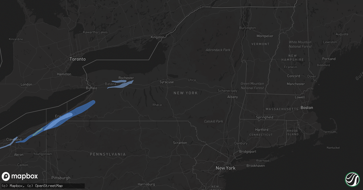
Hail Map in New York on April 25, 2022
Get this storm
April 25 map
$229
one time, instant access
Download today. No call, no setup
Keep the $229
Bought the map and want the full workflow? Apply the entire $229 to a subscription within 7 days. None of it is wasted.
Every map, not just this one
This buys you this map. Subscription and you get every map we run, in the markets you choose from a few cities to whole states to nationwide. Plus real-time alerts the moment a storm fires.
Contact data
Name, contact info, occupancy, even credit band for addresses in the footprint. You go from where it hit to who to call.
Become the source they trust
Unlimited branding weather history reports on demand. You already have the documented answer ready for the property owner, and you are the one who showed up with it.
Property data and RoofTrace estimates
Pull up any address you have got, its value and the exact code rules for that jurisdiction, straight from One Click Code. Then RoofTrace estimates the squares, pitch, and roof value, priced the way you price.
Storm reports in New York
New York
| Date | Description |
|---|---|
| 04/25/20226:33 PM CDT | Tree limbs and wires down blocking the road. Social media report. |
| 04/25/20226:32 PM CDT | Tree and wires down at golf ave and marsh road. |
| 04/25/20226:30 PM CDT | Numerous large tree limbs and wires down. Social media report. |
| 04/25/20226:29 PM CDT | Tree and wires down at hawthorne street. |
| 04/25/20226:25 PM CDT | Tree and wires down on frost avenue. |
| 04/25/20226:15 PM CDT | Large tree down across maxwell station rd. |
| 04/25/20226:10 PM CDT | Road sign blown down along interstate 390 near exit 7. |
| 04/25/20225:50 PM CDT | Report of tree down in the village. |
| 04/25/20225:43 PM CDT | Tree limbs down across route 98. |
| 04/25/20225:43 PM CDT | Power pole and lines down. |
| 04/25/20225:42 PM CDT | Nws storm survey confirms an ef-0 tornado occurred last evening in the town of alexander. Two rolled trailers... Three structures with roof damage... One structure with |
| 04/25/20225:05 PM CDT | Lines and tree down on leon road. |
| 04/25/20224:35 PM CDT | Power lines down at harvey and pickard road. |
| 04/25/20224:34 PM CDT | Trees and powerlines down. |
| 04/25/20224:26 PM CDT | Tree and wires down at thum road and bayview road. |
| 04/25/20224:25 PM CDT | Tree and wires down across route 430. |
| 04/25/20224:25 PM CDT | Large conifer tree down across both lanes of route 430. |
| 04/25/20224:10 PM CDT | Trees down across titus road. |
| 04/25/20224:00 PM CDT | Trees and powerlines down. |
| 04/25/20222:50 AM CDT | At 749 PM EDT, severe thunderstorms were located along a line extending from near Ontario to near Bristol, moving east at 50 mph. HAZARD...60 mph wind gusts. SOURCE...Radar indicated. IMPACT...Expect damage to trees and power lines. Locations impacted include... Geneva, Canandaigua, Fair Haven, Newark, Williamson, Marion, Lyons, Palmyra, Clifton Springs and Clyde.This includes Interstate 90 between exits 43 and 42. |
| 04/25/20222:08 AM CDT | At 707 PM EDT, severe thunderstorms were located along a line extending from near Holley to near Mount Morris, moving northeast at 40 mph. HAZARD...70 mph wind gusts and penny size hail. SOURCE...Radar indicated. IMPACT...Expect considerable tree damage. Damage is likely to mobile homes, roofs, and outbuildings. Locations impacted include... Churchville, Holley, Lima, Caledonia, Rochester, Greece, Irondequoit, Chili, Canandaigua, Brockport, Geneseo, East Rochester, Hilton and Webster.This includes the following highways... Interstate 390 between exits 6 and 12. Interstate 90 between exits 46 and 43. |
| 04/25/20221:34 AM CDT | At 633 PM EDT, severe thunderstorms were located along a line extending from Middleport to 6 miles southeast of Wales Center, moving northeast at 55 mph. HAZARD...60 mph wind gusts. SOURCE...Radar indicated. IMPACT...Expect damage to trees and power lines. Locations impacted include... Batavia, Brockport, Medina, Albion, Darien Lakes State Park, Le Roy, Pembroke, Bennington, Attica, Alexander, Akron and Alden.This includes Interstate 90 between exits 48A and 47. |
| 04/25/20221:21 AM CDT | At 621 PM EDT, a severe thunderstorm was located over Chaffee, or 15 miles south of East Aurora, moving east at 45 mph. HAZARD...60 mph wind gusts. SOURCE...Radar indicated. IMPACT...Expect damage to trees and power lines. Locations impacted include... Yorkshire, Geneseo, Letchworth State Park, Perry, Warsaw, Mount Morris, Arcade, Chaffee, East Concord, and Portageville.This includes Interstate 390 between exits 6 and 7. |
| 04/25/202212:25 AM CDT | At 523 PM EDT, a severe thunderstorm was located near Long Point State Park, or 12 miles northwest of Jamestown, moving northeast at 45 mph. HAZARD...70 mph wind gusts. SOURCE...Radar indicated. IMPACT...Expect considerable tree damage. Damage is likely to mobile homes, roofs, and outbuildings. Locations impacted include... Jamestown, Cherry Creek, Cassadaga, South Dayton, Springville, Lakewood, Gowanda, Falconer, Ashford, North Collins, Jamestown West and Ashford Hollow.This includes Interstate 86 between exits 9 and 16. |
| 04/24/202211:38 PM CDT | At 436 PM EDT, a severe thunderstorm was located near Waterford, or 8 miles southeast of Erie, moving northeast at 50 mph. HAZARD...60 mph wind gusts. SOURCE...Radar indicated. This storm has a history of producing strong wind gusts and wind damage across northwest Pennsylvania. IMPACT...Expect damage to trees and power lines. Locations impacted include... Findley Lake, Jamestown, Westfield, Lakewood, Falconer, Mayville, Clymer, Sherman, and Chautauqua Institution.This includes Interstate 86 between exits 4 and 13. |
| 04/24/202211:17 PM CDT | At 417 PM EDT, a severe thunderstorm was located over Albion, or 11 miles east of Conneaut, moving east at 50 mph. HAZARD...60 mph wind gusts. SOURCE...Trained weather spotters. IMPACT...Expect damage to trees and power lines. Locations impacted include... Erie, Corry, Edinboro, Union City, Girard, Waterford, Albion, Wattsburg, Northwest Harborcreek, Cranesville, Platea, Mill Village and McKean. |
All States Impacted by Hail Map on April 25, 2022
Cities Impacted by Hail Map on April 25, 2022
- Mertzon, TX
- Brackettville, TX
- Del Rio, TX
- Delmita, TX
- Rio Grande City, TX
- Rocksprings, TX
- Hebbronville, TX
- Kenedy, TX
- Dryden, TX
- Comstock, TX
- Roma, TX
- George West, TX
- Ozona, TX
- Falfurrias, TX
- Runge, TX
- Concepcion, TX
- Encino, TX
- Alice, TX
- Orange Grove, TX
- Charlotte, TX
- Jourdanton, TX
- Realitos, TX
- Santa Elena, TX
- San Isidro, TX
- Premont, TX
- Beeville, TX
- Iraan, TX
- Fulton, MS
- San Diego, TX
- Cotulla, TX
- Sandia, TX
- Three Rivers, TX
- Nordheim, TX
- Yorktown, TX
- Linn, TX
- Zapata, TX
- Shiner, TX
- Gonzales, TX
- Smithville, MS
- Carrizo Springs, TX
- Jefferson, OH
- Kingsville, OH
- Montville, OH
- Rome, OH
- Rock Creek, OH
- Brookpark, OH
- Wakeman, OH
- Olmsted Falls, OH
- Lagrange, OH
- Berea, OH
- Columbia Station, OH
- Grafton, OH
- Wellington, OH
- New London, OH
- Cleveland, OH
- Oberlin, OH
- Strongsville, OH
- Norwalk, OH
- Collins, OH
- North Fairfield, OH
- Monroeville, OH
- Willard, OH
- Findley Lake, NY
- Edinboro, PA
- Sinclairville, NY
- Newbury, OH
- Springville, NY
- Beachwood, OH
- Dorset, OH
- Bemus Point, NY
- Gerry, NY
- Mayville, NY
- Conneaut, OH
- Chardon, OH
- Windsor, OH
- Albion, PA
- Cambridge Springs, PA
- Waterford, PA
- Chesterland, OH
- Cherry Creek, NY
- Conewango Valley, NY
- Wattsburg, PA
- Chagrin Falls, OH
- Solon, OH
- Huntsburg, OH
- Perrysburg, NY
- Irving, NY
- Erie, PA
- Cattaraugus, NY
- South Dayton, NY
- Sherman, NY
- Westfield, NY
- Chautauqua, NY
- Girard, PA
- East Otto, NY
- Conneautville, PA
- Pierpont, OH
- Fairview, PA
- Springboro, PA
- Cassadaga, NY
- Bedford, OH
- Lawtons, NY
- Panama, NY
- Collins, NY
- Forestville, NY
- Austinburg, OH
- Brocton, NY
- Jamestown, NY
- Novelty, OH
- Maple Heights, OH
- Burton, OH
- McKean, PA
- Ashville, NY
- North East, PA
- Clymer, NY
- Harborcreek, PA
- Dewittville, NY
- Union City, PA
- Cranesville, PA
- Gowanda, NY
- Dayton, NY
- Stockton, NY
- Fredonia, NY
- Ripley, NY
- North Collins, NY
- Thompson, OH
- Lily Dale, NY
- Victor, NY
- Avon, NY
- Henrietta, NY
- Attica, NY
- Le Roy, NY
- Pavilion, NY
- Pittsford, NY
- Mendon, NY
- Alexander, NY
- Honeoye Falls, NY
- Caledonia, NY
- Scottsville, NY
- Fairport, NY
- Rush, NY
- East Bethany, NY
- Linwood, NY
- Macedon, NY
- North Chili, NY
- Bergen, NY
- South Byron, NY
- Rochester, NY
- West Henrietta, NY
- Churchville, NY
- Elba, NY
- Byron, NY
- Edgemont, SD
- Hot Springs, SD
- Custer, SD


