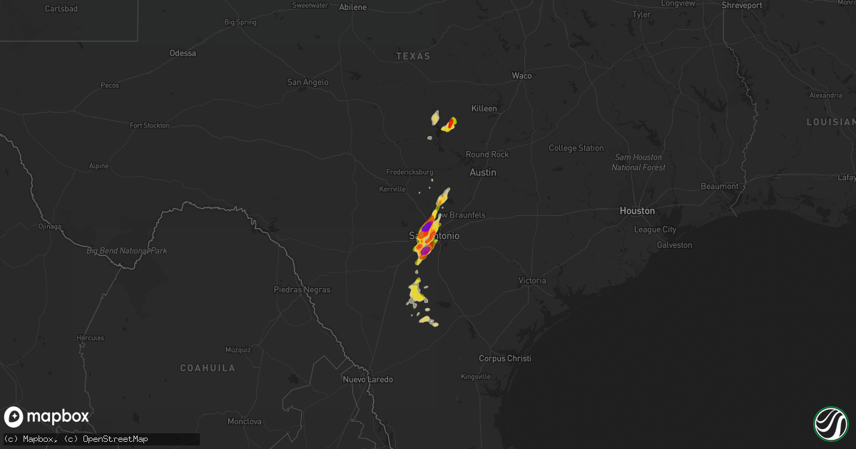
Hail Map on April 25, 2016
Get this storm
April 25 map
$229
one time, instant access
Download today. No call, no setup
Keep the $229
Bought the map and want the full workflow? Apply the entire $229 to a subscription within 7 days. None of it is wasted.
Every map, not just this one
This buys you this map. Subscription and you get every map we run, in the markets you choose from a few cities to whole states to nationwide. Plus real-time alerts the moment a storm fires.
Contact data
Name, contact info, occupancy, even credit band for addresses in the footprint. You go from where it hit to who to call.
Become the source they trust
Unlimited branding weather history reports on demand. You already have the documented answer ready for the property owner, and you are the one who showed up with it.
Property data and RoofTrace estimates
Pull up any address you have got, its value and the exact code rules for that jurisdiction, straight from One Click Code. Then RoofTrace estimates the squares, pitch, and roof value, priced the way you price.
States Impacted by Hail Map on April 25, 2016
Storm reports
Kansas
| Date | Description |
|---|---|
| 04/25/20166:52 AM CDT | 30-40 mph winds |
| 04/25/20166:42 AM CDT | Time estimated by radar |
| 04/25/20166:19 AM CDT | A local report indicates 1.00 inch wind near 4 SSW BAILEYVILLE |
| 04/25/20166:19 AM CDT | A local report indicates 60 MPH wind near 4 SSW BAILEYVILLE |
| 04/25/20166:10 AM CDT | Wind flipped carport...blew it into trees...and held it in the trees. Estimated 75 to 80 mph. |
| 04/25/20166:03 AM CDT | Time estimated by radar |
| 04/25/20166:02 AM CDT | Mostly peas but a few dime and quarter size. |
| 04/25/20165:49 AM CDT | A local report indicates 1.00 inch wind near MARYSVILLE |
| 04/25/20165:28 AM CDT | Walnut size hail reported via social media. |
| 04/25/20164:38 AM CDT | A local report indicates 1.50 inch wind near MARYSVILLE |
| 04/25/20164:36 AM CDT | A local report indicates 1.00 inch wind near 1 SW MARYSVILLE |
| 04/25/20164:23 AM CDT | A local report indicates 2.50 inch wind near WASHINGTON |
| 04/25/20164:00 AM CDT | A local report indicates 1.75 inch wind near LINN |
| 04/25/20163:47 AM CDT | A local report indicates 1.50 inch wind near 3 E CUBA |
| 04/25/20163:37 AM CDT | A local report indicates 2.00 inch wind near 6 ESE AGENDA |
| 04/25/20163:06 AM CDT | Report relayed from nws topeka...report via facebook. Time is estimated by radar. |
| 04/25/20163:05 AM CDT | Hail was between quarter and golf ball size. Hail was ongoing between 245 am and 305 am. |
| 04/25/20162:55 AM CDT | Cocorahs observer. Time adjusted earlier than observer report to better match radar data. |
Wisconsin
| Date | Description |
|---|---|
| 04/25/20165:50 PM CDT | Junction of howell ave. And puetz road. |
| 04/25/20165:38 PM CDT | A local report indicates 1.00 inch wind near 2 SW PORT WASHINGTON |
| 04/25/20165:37 PM CDT | A local report indicates 1.00 inch wind near 3 SSE GRAFTON |
| 04/25/20165:35 PM CDT | Duration of five minutes. |
| 04/25/20165:35 PM CDT | A local report indicates 1.75 inch wind near PORT WASHINGTON |
| 04/25/20165:08 PM CDT | Junction of 41 and hwy 60. |
| 04/25/20164:59 PM CDT | Relayed via facebook. |
| 04/25/20164:01 PM CDT | Relayed through mping. |
Missouri
| Date | Description |
|---|---|
| 04/25/20166:49 AM CDT | A local report indicates 1.00 inch wind near ST JOSEPH |
| 04/25/20166:47 AM CDT | A local report indicates 1.00 inch wind near ST JOSEPH |
Illinois
| Date | Description |
|---|---|
| 04/25/20166:25 PM CDT | A local report indicates 1.00 inch wind near GLENVIEW |
| 04/25/20165:40 PM CDT | Nearest intersection us-20 and mcclean boulevard. |
| 04/25/20165:15 PM CDT | Hail ranged in size from one quarter inch to one inch in diameter. Hail fell roughly from 510pm to 515pm. |
| 04/25/20164:40 PM CDT | Along highway 120. Report via twitter. Time estimated from radar. |
| 04/24/20169:45 PM CDT | In lincoln park. |
| 04/24/20169:40 PM CDT | Via facebook. Nearest intersection irving park and pulaski. |
| 04/24/20169:32 PM CDT | Nearest intersection montrose and ottawa. Via facebook. |
| 04/24/20169:31 PM CDT | Far northwest side of chicago. Relayed via facebook. |
| 04/24/20167:16 PM CDT | Hail from about 716 to 721 pm. Nearest intersection route 31 and algonquin road. |
| 04/24/20167:15 PM CDT | Hail between quarter and half dollar size between 715pm and 721pm. New report from algonquin area. |
| 04/24/20167:15 PM CDT | Butterfield and north huntington nearest intersections. Relayed via facebook. |
| 04/24/20167:15 PM CDT | Estimated up to walnut size. Via twitter. |
| 04/24/20167:10 PM CDT | At carmel high school. 176 and hawley. |
| 04/24/20167:09 PM CDT | Near chevy chase road. |
| 04/24/20167:06 PM CDT | Damage to multiple vehicles and a skylight in a home. Route 12 and 176. |
Colorado
| Date | Description |
|---|---|
| 04/25/20163:22 AM CDT | A local report indicates 1.50 inch wind near 19 NNE WRAY |
| 04/24/20169:28 PM CDT | Mushy hail |
Michigan
| Date | Description |
|---|---|
| 04/25/20166:59 PM CDT | Ham radio operator relayed report of 5 inch tree limbs down. Utility crew onsite. Time of occurrence estimated by radar. |
| 04/25/20166:42 PM CDT | Public sent in a photo of quarter size hail. Relayed by the media. Courtesy wzzm-tv. Time estimated by radar. |
| 04/24/201611:20 PM CDT | Several trees downed. One fell on a parked car and one fell on a house. Also a few windows blown out and one old shed was destroyed. |
| 04/24/201610:20 PM CDT | Report of tree and power line down per em and branch county dispatch |
| 04/24/201610:05 PM CDT | Delayed report. |
| 04/24/20169:20 PM CDT | Reported that the hail was quite large... But estimated it was slightly bigger than a quarter. Delayed report. |
| 04/24/20168:30 PM CDT | Report relayed by emergency management. |
| 04/24/20168:30 PM CDT | Spotter reported hail slightly larger than a quarter. Lasted from 9:30 pm to 9:34 pm |
| 04/24/20168:22 PM CDT | A local report indicates 1.00 inch wind near HOPKINS |
| 04/24/20167:58 PM CDT | Report sent in via social media. Time estimate by radar. |
| 04/24/20167:55 PM CDT | Several reports |
| 04/24/20167:55 PM CDT | Pictures shared out by local broadcast media of golf ball size hail. Time estimated by radar. Courtesy wood-tv |
| 04/24/20167:51 PM CDT | Most hail was nickel size. Few were quarter size. |
| 04/24/20167:45 PM CDT | A local report indicates 1.00 inch wind near 3 W COMSTOCK PARK |
| 04/24/20167:42 PM CDT | Reported at kenowa hills high school. Relayed by broadcast media. Courtesy of wzzm-tv. Time estimate by radar. |
| 04/24/20167:41 PM CDT | Report relayed by emergency management. |
| 04/24/20167:30 PM CDT | A local report indicates 1.25 inch wind near LAMONT |
| 04/24/20167:21 PM CDT | Public sent in a picture via social media. Time estimated by radar. |
Wyoming
| Date | Description |
|---|---|
| 04/25/20166:07 PM CDT | Said hail ranged from pea to 1 inch. Seemed fairly hard. |
Ohio
| Date | Description |
|---|---|
| 04/25/20162:17 AM CDT | Reports and photos of several small trees downed and a wall of a three seasons porch damaged near the 800 block of marks road. |
| 04/25/20162:17 AM CDT | Roof of home damaged on stonehurst drive in brunswick hills. |
Nebraska
| Date | Description |
|---|---|
| 04/25/20165:45 AM CDT | Delayed report of early morning hail. |
| 04/25/20163:57 AM CDT | Report via facebook with picture. Time estimated by radar. |
| 04/25/20163:12 AM CDT | Report via facebook. |
Delaware
| Date | Description |
|---|---|
| 04/24/201611:32 PM CDT | A local report indicates 1.00 inch wind near WILMINGTON |
Texas
| Date | Description |
|---|---|
| 04/25/20166:58 PM CDT | 1 inch hail near intersection of loop 1604 and u.s. Highway 281 |
| 04/25/20166:58 PM CDT | Quarter-sized hail reported 1 mile south of blanco road and loop 1604 |
| 04/25/20166:50 PM CDT | Mostly nickel to ping pong size hail...with occasional golf ball to 2 inch hail...at vance jackson and de zavalla |
| 04/25/20166:48 PM CDT | 2.75 inch hail reported near usaa at huebner and i-10 |
| 04/25/20166:45 PM CDT | Reported at san antonio methodist hospital on floyd curl drive |
| 04/25/20166:45 PM CDT | 1 inch hail reported near alamo heights high school in san antonio |
| 04/25/20166:45 PM CDT | 2.5 inch hail reported near dezavala and i-10 in san antonio |
| 04/25/20166:42 PM CDT | At the medical center |
| 04/25/20166:40 PM CDT | 1.5 inch hail reported at culebra and ingram road |
| 04/25/20166:37 PM CDT | Golf ball hail reported near 151 and potranco road in san antonio |
| 04/25/20166:33 PM CDT | Quarter-sized hail reported near i-10 and 410 near balcones heights |
| 04/25/20166:32 PM CDT | A local report indicates 1.00 inch wind near SEA WORLD |
| 04/25/20166:31 PM CDT | 1.75 inch hail reported 1 mile south of south park mall |
| 04/25/20166:30 PM CDT | 1.25 inch hail reported at us 90 and ray ellison boulevard |
| 04/25/20166:25 PM CDT | Golf ball hail reported near five palms drive and trading post street in san antonio |
| 04/25/20166:23 PM CDT | 1 inch hail reported near intersection of vista point and vista grove in southwest san antonio |
| 04/25/20166:22 PM CDT | 1 inch hail reported near roosevelt and ashley street |
| 04/25/20166:15 PM CDT | 1.75 inch hail reported at loop 1604 and highway 16 |
| 04/25/20166:10 PM CDT | 1 inch hail reported in town of lytle |
| 04/25/20166:07 PM CDT | 2.5 inch hail reported in town of von ormy |
| 04/25/20166:00 PM CDT | 2.5 inch hail reported 5 miles south of somerset |
| 04/25/20165:54 PM CDT | Report of hail near 2 inches in the town of somerset. |
| 04/24/20169:20 PM CDT | Multiple reports of golf ball size hail along hwy 281 between burnet and lampassas. |
| 04/24/20168:47 PM CDT | Quarter size hail northwest of burnet |
| 04/24/20167:30 PM CDT | A local report indicates 1.50 inch wind near SPRING BRANCH |
| 04/24/20167:10 PM CDT | 1 inch hail reported near timberwood park |
| 04/24/20167:05 PM CDT | 1 inch hail reported near wilderness oak and hardy oak boulevard |
| 04/24/20167:02 PM CDT | 1.50 inch hail reported 1 mile south of loop 1604 and blanco road in san antonio |
Cities Impacted by Hail Map on April 25, 2016
- Fennville, MI
- Hamilton, MI
- Saint Joseph, MO
- Elwood, KS
- Wathena, KS
- Lebanon, KS
- Imperial, NE
- Madrid, NE
- Spring Branch, TX
- Canyon Lake, TX
- Oconomowoc, WI
- Germantown, WI
- Hartford, WI
- Richfield, WI
- Cedarburg, WI
- Grafton, WI
- Hartland, WI
- Hubertus, WI
- Mequon, WI
- Colgate, WI
- Jackson, WI
- Otsego, MI
- Pullman, MI
- Martin, MI
- Delton, MI
- Plainwell, MI
- South Haven, MI
- Shelbyville, MI
- Allegan, MI
- Hopkins, MI
- Greenleaf, KS
- Green, KS
- Wray, CO
- Holyoke, CO
- Casnovia, MI
- Bailey, MI
- Grant, MI
- Clyde, KS
- Bern, KS
- Seneca, KS
- Oneida, KS
- Wayland, MI
- Watervliet, MI
- Benton Harbor, MI
- Coloma, MI
- Hartford, MI
- Cotulla, TX
- Pearsall, TX
- Fowlerton, TX
- Centralia, KS
- Goff, KS
- Corning, KS
- Champion, NE
- Bremen, KS
- Summerfield, KS
- Oketo, KS
- Waterville, KS
- Washington, KS
- Axtell, KS
- Beattie, KS
- Frankfort, KS
- Burchard, NE
- Baileyville, KS
- Home, KS
- Morrowville, KS
- Hanover, KS
- Marysville, KS
- Clifton, KS
- Pawnee City, NE
- Linn, KS
- Palmer, KS
- Barnes, KS
- Egg Harbor City, NJ
- Bruning, NE
- Belvidere, NE
- Ohiowa, NE
- Tobias, NE
- Alexandria, NE
- Elkhart, IN
- Bridgeport, NE
- Endicott, NE
- Steele City, NE
- Hollenberg, KS
- Formoso, KS
- Jewell, KS
- Randall, KS
- Beloit, KS
- Mankato, KS
- Haddam, KS
- Agenda, KS
- Vermillion, KS
- Jamestown, KS
- Burnet, TX
- Hebron, NE
- Marne, MI
- Zeeland, MI
- Grand Rapids, MI
- Allendale, MI
- Lampasas, TX
- North Adams, MI
- Quincy, MI
- Allen, MI
- Litchfield, MI
- Jonesville, MI
- Hillsdale, MI
- Glenview, IL
- Golf, IL
- Morton Grove, IL
- Northbrook, IL
- Elk Grove Village, IL
- Schaumburg, IL
- Evanston, IL
- Skokie, IL
- Winnetka, IL
- Kenilworth, IL
- Niles, IL
- Des Plaines, IL
- Wilmette, IL
- Mount Prospect, IL
- Arlington Heights, IL
- Valley Falls, KS
- Nortonville, KS
- Ozawkie, KS
- Effingham, KS
- Meriden, KS
- Tilden, TX
- Charlotte, TX
- San Saba, TX
- Lake Zurich, IL
- Barrington, IL
- Cary, IL
- Saukville, WI
- Port Washington, WI
- Dickens, NE
- Bulverde, TX
- Von Ormy, TX
- Jbsa Lackland, TX
- San Antonio, TX
- Lytle, TX
- Atascosa, TX
- Somerset, TX
- Poteet, TX
- Castle Rock, CO
- Carleton, NE
- Davenport, NE
- Cedar Grove, WI
- Oostburg, WI
- Sibley, MO
- Tuckerton, NJ
- Kansas City, KS
- Courtland, KS
- Norway, KS
- Slinger, WI
- West Bend, WI
- Muskegon, MI
- Spring Lake, MI
- Nunica, MI
- Ravenna, MI
- Fruitport, MI
- Chester, NE
- Oak Creek, WI
- Grayslake, IL
- Gurnee, IL
- Chatsworth, NJ
- Vincentown, NJ
- Barnegat, NJ
- Orrick, MO
- Independence, MO
- Clayton, NJ
- Monroeville, NJ
- Franklinville, NJ
- Williamstown, NJ
- Glendale Heights, IL
- Bloomingdale, IL
- River Grove, IL
- Elmwood Park, IL
- Addison, IL
- Melrose Park, IL
- Bensenville, IL
- Chicago, IL
- Lombard, IL
- Carol Stream, IL
- Glen Ellyn, IL
- Elmhurst, IL
- Villa Park, IL
- Franklin Park, IL
- Dorr, MI
- Wauconda, IL
- Mundelein, IL
- White Cloud, KS
- Hiawatha, KS
- Robinson, KS
- Union City, MI
- Bronson, MI
- Tekonsha, MI
- Coldwater, MI
- Colon, MI
- Mendon, MI
- Leonidas, MI
- Sherwood, MI
- Rushville, MO
- Scandia, KS
- Belleville, KS
- Sedgwick, CO
- Ovid, CO
- Hardy, NE
- Elgin, IL
- Saint Charles, IL
- West Olive, MI
- Findlay, OH
- Mchenry, IL
- Penns Grove, NJ
- Wilmington, DE
- Newark, DE
- New Castle, DE
- Pedricktown, NJ
- Jerome, MI
- Leavenworth, KS
- Blanco, TX
- Nelson, NE
- Republic, KS
- Webber, KS
- Eckley, CO
- Yuma, CO
- Comfort, TX
- Boerne, TX
- Milwaukee, WI
- Forest City, MO
- Highland, KS
- Fox Lake, IL
- Lyons, MI
- Wetmore, KS
- Holton, KS
- Circleville, KS
- Narka, KS
- Munden, KS
- Metamora, OH
- Blissfield, MI
- Whiting, KS
- Netawaka, KS
- Hudsonville, MI
- Holland, MI
- Wyoming, MI
- Ada, MI
- Comstock Park, MI
- Coopersville, MI
- Jenison, MI
- Byron Center, MI
- Towanda, IL
- Marengo, IL
- Harvard, IL
- Garden Prairie, IL
- Belvidere, IL
- Fischer, TX
- Grand Haven, MI
- Sabetha, KS
- South Elgin, IL
- Shawnee, KS
- Toledo, OH
- Bennett, CO
- Reading, MI
- Decatur, MI
- Centreville, MI
- Lawton, MI
- Covert, MI
- Three Rivers, MI
- Dowagiac, MI
- Burr Oak, MI
- Marcellus, MI
- Inavale, NE
- Red Cloud, NE
- Franksville, WI
- Union Grove, WI
- Waterford, WI
- Waterford Works, NJ
- Sicklerville, NJ
- Waretown, NJ
- Hammonton, NJ
- Centerville, KS
- Blue Mound, KS
- Calliham, TX
- Elkton, MD
- Cheyenne, WY
- Sturtevant, WI
- Brigantine, NJ
- Caledonia, MI
- Weston, MO
- Addison, MI
- Pittsford, MI
- Hudson, MI
- Manitou Beach, MI
- De Kalb, MO
- Tow, TX
- Brookfield, WI
- Burlington, WI
- Chappell, NE
- Humboldt, NE
- Libertyville, IL
- Hampshire, IL
- Carpentersville, IL
- Lake Bluff, IL
- Buffalo Grove, IL
- Huntley, IL
- Palatine, IL
- Lincolnshire, IL
- Lake Forest, IL
- Fox River Grove, IL
- Vernon Hills, IL
- Deerfield, IL
- Gilberts, IL
- Dundee, IL
- Algonquin, IL
- Racine, WI
- Adell, WI
- Waldo, WI
- Random Lake, WI
- North Platte, NE
- Cuba, KS
- Mahaska, KS
- Fairbury, NE
- Middleville, MI
- Hastings, MI
- Du Bois, NE
- Crystal Lake, IL
- Ingleside, IL
- Round Lake, IL
- Onaga, KS
- Alexandria, OH
- Pataskala, OH
- Morganville, KS
- Kansas City, MO
- Wimberley, TX
- Jourdanton, TX
- Waukegan, IL
- Lake Villa, IL
- Woodstock, IL
- Island Lake, IL
- Belgium, WI
- Anchor, IL
- Sibley, IL
- Horton, KS
- Gilead, NE
- Deshler, NE
- Elmer, NJ
- Angora, NE
- Liberty, NE
- Westmoreland, KS
- Hubbell, NE
- Powhattan, KS
- Soldier, KS
- Blue Rapids, KS
- Grand Junction, MI
- Bloomingdale, MI
- Fairview, KS
- Vernon, CO
- Cummings, KS
- Paw Paw, MI
- Lawrence, MI
- Ruskin, NE
- Oak, NE
- Byron, NE
- Elizabeth, CO
- Prospect Heights, IL
- Highwood, IL
- Highland Park, IL
- Wheeling, IL
- Platte City, MO
- Wheatland, WY
- Topeka, KS
- Bowling Green, OH
- Weston, OH
- Hye, TX
- Palmyra, MI
- Park Ridge, IL
- Ashley, OH
- Waldo, OH
- Cardington, OH
- Saugatuck, MI
- Douglas, MI
- Jbsa Ft Sam Houston, TX
- South Milwaukee, WI
- Franklin, WI
- Belmont, MI
- Rubicon, WI
- McClure, OH
- Mishawaka, IN
- South Bend, IN
- Elm Grove, WI
- Llano, TX
- Haigler, NE
- Grandville, MI
- Mapleton, KS
- Parker, CO
- Menomonee Falls, WI
- Foosland, IL
- Harwood Heights, IL
- Hanover Park, IL
- Bartlett, IL
- West Chicago, IL
- Schiller Park, IL
- Easton, KS
- Newfield, NJ
- Berlin, NJ
- Lenexa, KS
- Bonner Springs, KS
- De Soto, KS
- Nevada, OH
- Harpster, OH
- Niles, MI
- Kenosha, WI
- Big Springs, NE
- Oregon, OH
- Harbor View, OH
- Ionia, MI
- Elsie, NE
- Kent City, MI
- Conklin, MI
- Enders, NE
- Benkelman, NE
- Agency, MO
- Maxwell, NE
- Kalamazoo, MI
- Ottawa Lake, MI
- Crook, CO
- Schoolcraft, MI
- Cassopolis, MI
- Edwardsburg, MI
- Meriden, WY
- Riga, MI
- Alvada, OH
- Wilmot, WI
- Salem, WI
- Bristol, WI
- Trevor, WI
- Twin Lakes, WI
- Superior, NE
- Eau Claire, MI
- Genoa, IL
- Kansasville, WI
- Bangor, MI
- Bigfoot, TX
- Natalia, TX
- Bosler, WY
- Claymont, DE
- Glassboro, NJ
- Forked River, NJ
- Wood Dale, IL
- Poplar Grove, IL