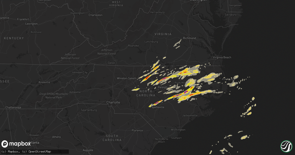
Hail Map on April 25, 2014
Get this storm
April 25 map
$229
one time, instant access
Download today. No call, no setup
Keep the $229
Bought the map and want the full workflow? Apply the entire $229 to a subscription within 7 days. None of it is wasted.
Every map, not just this one
This buys you this map. Subscription and you get every map we run, in the markets you choose from a few cities to whole states to nationwide. Plus real-time alerts the moment a storm fires.
Contact data
Name, contact info, occupancy, even credit band for addresses in the footprint. You go from where it hit to who to call.
Become the source they trust
Unlimited branding weather history reports on demand. You already have the documented answer ready for the property owner, and you are the one who showed up with it.
Property data and RoofTrace estimates
Pull up any address you have got, its value and the exact code rules for that jurisdiction, straight from One Click Code. Then RoofTrace estimates the squares, pitch, and roof value, priced the way you price.
States Impacted by Hail Map on April 25, 2014
Storm reports
Virginia
| Date | Description |
|---|---|
| 04/25/20143:35 PM CDT | Tree down in bon air blocking the road. |
| 04/25/20143:24 PM CDT | Multiple trees down and uprooted |
| 04/25/20143:15 PM CDT | Multiple trees down in the redfield neighborhood. |
| 04/25/20143:10 PM CDT | A local report indicates 1.00 inch wind near W SCOTTSBURG |
| 04/25/20143:07 PM CDT | A local report indicates 1.00 inch wind near 5 SE HALIFAX |
| 04/25/20142:30 PM CDT | Tree down just east of madisonville |
| 04/25/20142:29 PM CDT | Tree down on abilene rd |
| 04/25/20142:09 PM CDT | Tree down on patrick henry hwy |
| 04/25/20141:16 PM CDT | One tree down on henderson road. |
| 04/25/20141:11 PM CDT | One tree down on calvary road. |
West Virginia
| Date | Description |
|---|---|
| 04/25/20145:45 PM CDT | Reports some powerlines and trees down. 1 tree is down on a house. Time estimated from radar |
North Carolina
| Date | Description |
|---|---|
| 04/25/20146:53 PM CDT | Spotter reported golf size hail at west 15th street and minute man lane |
| 04/25/20146:50 PM CDT | Golf ball size hail reported on summit ave in washington |
| 04/25/20146:47 PM CDT | One inch hail reported by spotter 1 4 mile sw of airport. |
| 04/25/20146:45 PM CDT | Trees down on several homes |
| 04/25/20146:43 PM CDT | Houses destroyed and powerlines down on snug harbor rd |
| 04/25/20146:42 PM CDT | Trees and powerlines down on burntsmille rd |
| 04/25/20146:42 PM CDT | Tornado on the ground. Visible by fire department personnel. |
| 04/25/20146:40 PM CDT | Trees down and uprooted reported by rescue squad personnel. |
| 04/25/20146:37 PM CDT | *** 2 inj *** houses destroyed on yeopim rd |
| 04/25/20146:35 PM CDT | Widespread trees down |
| 04/25/20146:33 PM CDT | Tornado reported on the ground near black jack |
| 04/25/20146:25 PM CDT | 2 structures damaged by wind |
| 04/25/20146:21 PM CDT | Golfball size hail reported at dh conley high school |
| 04/25/20146:20 PM CDT | Cocorahs observer reported golf ball size and larger hail denting car roofs and stripping vegetation off trees. |
| 04/25/20146:19 PM CDT | Trees and powerlines down near macedonia rd and chambers ferry rd |
| 04/25/20146:15 PM CDT | Voice of america employees watched a rope tornado touch down in the field at voa site b. No damage observed. |
| 04/25/20146:10 PM CDT | Golf ball size hail reported in ayden |
| 04/25/20145:48 PM CDT | Two trees were reported down near u.s. 117 alt and yank rd. |
| 04/25/20145:45 PM CDT | Quarter size hail reported in hookerton |
| 04/25/20145:40 PM CDT | Quarter size reported along dawson station rd. |
| 04/25/20145:40 PM CDT | Golf ball size hail reported in snow hill |
| 04/25/20145:37 PM CDT | Penny to quarter size hail was reported near sugar hill road near mile marker 127 on i-95. |
| 04/25/20145:35 PM CDT | Trees down and damaged deck on catawba and mitchner drives in the wilson mills community. |
| 04/25/20145:34 PM CDT | Two trees were reported down near the intersection of woodland dr and pineview ave. |
| 04/25/20145:30 PM CDT | Trees and powerlines down with a possible wall cloud. |
| 04/25/20145:16 PM CDT | Reported quarter size hail. Time based from radar. |
| 04/25/20145:03 PM CDT | Power lines were reported down at silvertown rd and norman rd. |
| 04/25/20144:52 PM CDT | Quarter size hail reported at the 911 center. |
| 04/25/20144:35 PM CDT | Several trees down in louisburg |
| 04/25/20144:25 PM CDT | Several trees down |
| 04/25/20144:20 PM CDT | Fire chief reported golf ball size hail in halifax |
| 04/25/20144:18 PM CDT | Spotter reported tornado 5 miles west of greenville near the voice of america radio station. |
| 04/25/20144:15 PM CDT | Tree down... Report relayed via skywarn |
| 04/25/20144:05 PM CDT | Quarter size hail north of roxboro |
| 04/25/20144:00 PM CDT | Numerous trees down in the asheboro area. |
| 04/25/20144:00 PM CDT | Nws employee reporte golf size hail off of chinquapin road in farmville. |
| 04/25/20143:55 PM CDT | A local report indicates 1.75 inch wind near BETHEL HILL |
| 04/25/20143:55 PM CDT | A local report indicates 1.75 inch wind near 4 WSW BETHEL HILL |
| 04/25/20143:40 PM CDT | Greene co. Fire chief reported tornado on the ground west of castoria. |
| 04/25/20143:39 PM CDT | Tree down in denton near the intersection of s. Main st and w noell ave |
| 04/25/20143:35 PM CDT | Tree down... Time estimated |
| 04/25/20143:31 PM CDT | Quarter size hail near pikeville |
| 04/25/20143:20 PM CDT | Tree down in lexington near intersection of central ave and w 5th ave |
| 04/25/20143:16 PM CDT | Tree down on a mobile home |
| 04/25/20143:10 PM CDT | Quarter size hail reported at franklinton high school |
| 04/25/20143:05 PM CDT | Roof off of a house... Damaged trees... Roof off of shed... Possible tornado damage near the intersection of ita road and medoc mountain road. |
| 04/25/20143:00 PM CDT | Possible tornado damage in the community of white level. Numerous snapped and uprooted trees. Several structures sustained damage. Time was estimated. |
| 04/25/20142:57 PM CDT | A local report indicates 1.00 inch wind near ASHEBORO |
| 04/25/20142:57 PM CDT | Tree across road. |
| 04/25/20142:55 PM CDT | Hail in southern asheboro |
| 04/25/20142:55 PM CDT | A local report indicates 1.75 inch wind near 3 SW NAHUNTA |
| 04/25/20142:54 PM CDT | Tree across road. |
| 04/25/20142:53 PM CDT | Nickel to quarter size hail |
| 04/25/20142:50 PM CDT | Homeowner in castalia reported funnel cloud and tree damage around the home |
| 04/25/20142:50 PM CDT | Tree down near intersection of needmore rd and cool springs rd. |
| 04/25/20142:47 PM CDT | Quarter size hail near surl |
| 04/25/20142:32 PM CDT | Building and roof damage near center of statesville... Nc. |
| 04/25/20142:28 PM CDT | Multiple trees down on neighborhood roads nw of statesville... Nc. |
| 04/25/20142:25 PM CDT | Garage doors blown in...siding off houses...bits of insulation on ground...trees down. About two miles west of intersection of highway 115 and scotts creek rd. |
| 04/25/20142:25 PM CDT | 1 inch hail near little river |
| 04/25/20142:20 PM CDT | Tree down on hill farm road east of hiddenite. |
| 04/25/20142:12 PM CDT | Spotter reports quarter size hail 1 mi north of franklinton |
| 04/25/20142:11 PM CDT | Spotter reports quarter size hail in franklinton |
| 04/25/20142:10 PM CDT | Tree blown down on d ave at main street. |
| 04/25/20142:03 PM CDT | Public report of nickle to quarter size hail at rt96 and rt56... Relayed via skywarn |
| 04/25/20141:53 PM CDT | Pea to penny size hail... With some up to quarter size. Report relayed via skywarn. |
| 04/25/20141:48 PM CDT | Quarter size hail at falls lake recreation area |
| 04/25/20141:30 PM CDT | Quarter size hail |
| 04/25/20141:25 PM CDT | Mping report. |
| 04/25/20141:25 PM CDT | 1 inch hail near little river. Corrected time. |
| 04/25/20141:08 PM CDT | Chapel hill fire department reported quarter size hail |
| 04/25/20141:05 PM CDT | A local report indicates 1.00 inch wind near FORT BRAGG |
| 04/25/20141:05 PM CDT | Large hail observed on bluebird lane |
| 04/25/20141:05 PM CDT | Reports of quarter size hail near spring lake |
| 04/25/201412:45 PM CDT | Golf ball size hail near exit 150 on interstate 40 |
| 04/25/201412:38 PM CDT | Quarter size hail in graham |
| 04/24/20147:37 PM CDT | Several trees down |
| 04/24/20147:37 PM CDT | Several trees down |
| 04/24/20147:28 PM CDT | Ef0 tornado with a 0.5 mile long...30 yard wide path of damage near jarvisburg. Trees down snapped off. Church outbuildings and playground damaged. |
| 04/24/20147:25 PM CDT | Sporadic damage along a 1.5 mile path near jarvisburg. Minor structural damage to jarvisburg elementary school and a nearby church. Outbuildings at the church destroyed |
| 04/24/20147:15 PM CDT | Elizabeth city raws. Time estimated from radar. |
| 04/24/20147:15 PM CDT | A local report indicates 64 MPH wind near ELIZABETH CITY |
| 04/24/20147:07 PM CDT | Possible tornado at halls creek rd as reported by 911 center |
| 04/24/20147:06 PM CDT | Mobile homes overturned on lobell ln |
| 04/24/20147:05 PM CDT | Trees down and uprooted reported by rescue squad personnel. |
| 04/24/20147:05 PM CDT | Several homes destroyed on foreman bundy rd |
| 04/24/20147:00 PM CDT | Spotter reported golf size hail in downtown grimesland |
| 04/24/20147:00 PM CDT | Houses destroyed and powerlines down on chapanoke rd |
Cities Impacted by Hail Map on April 25, 2014
- Liberty, NC
- Graham, NC
- Haw River, NC
- Burlington, NC
- Cedar Grove, NC
- Efland, NC
- Mebane, NC
- Jamesville, NC
- Williamston, NC
- Drakes Branch, VA
- Wylliesburg, VA
- Red Oak, VA
- Chase City, VA
- Halifax, NC
- Hurdle Mills, NC
- Rougemont, NC
- Roxboro, NC
- Oxford, NC
- Timberlake, NC
- Julian, NC
- Weldon, NC
- Littleton, NC
- Hollister, NC
- Enfield, NC
- Garysburg, NC
- Jackson, NC
- Roanoke Rapids, NC
- Stem, NC
- Wanchese, NC
- Nags Head, NC
- Manteo, NC
- Carrboro, NC
- Chapel Hill, NC
- Scotland Neck, NC
- Woodland, NC
- Ahoskie, NC
- Aulander, NC
- Rich Square, NC
- Conway, NC
- Walstonburg, NC
- Greenville, NC
- Farmville, NC
- Raleigh, NC
- Murfreesboro, NC
- Erwin, NC
- South Boston, VA
- Clayton, NC
- Wendell, NC
- Windsor, NC
- Hertford, NC
- Edenton, NC
- Elizabeth City, NC
- Tyner, NC
- Merry Hill, NC
- Colerain, NC
- Princeton, NC
- Goldsboro, NC
- Bethel, NC
- Stokes, NC
- Robersonville, NC
- Warrenton, NC
- Norlina, NC
- Pendleton, NC
- Margarettsville, NC
- Tarboro, NC
- Smithfield, NC
- Franklinville, NC
- Asheboro, NC
- Ramseur, NC
- Denton, NC
- Pikeville, NC
- Winterville, NC
- Grimesland, NC
- Snow Hill, NC
- Fremont, NC
- Four Oaks, NC
- Benson, NC
- Fountain, NC
- Stantonsburg, NC
- Oak City, NC
- Apex, NC
- Youngsville, NC
- Wake Forest, NC
- Franklinton, NC
- Creedmoor, NC
- Rocky Mount, NC
- Wilson, NC
- Willow Spring, NC
- Black Creek, NC
- Garner, NC
- Lucama, NC
- Kenly, NC
- Selma, NC
- Engelhard, NC
- Fairfield, NC
- La Grange, NC
- Seven Springs, NC
- Hookerton, NC
- Kinston, NC
- Hobgood, NC
- Semora, NC
- Halifax, VA
- Leasburg, NC
- Scottsburg, VA
- Alton, VA
- Zebulon, NC
- Middlesex, NC
- Linden, NC
- Fayetteville, NC
- Spring Lake, NC
- Fort Bragg, NC
- Durham, NC
- Hamilton, NC
- Washington, NC
- Elm City, NC
- Bailey, NC
- Whitsett, NC
- Belhaven, NC
- Pinetown, NC
- Pantego, NC
- Grifton, NC
- Chocowinity, NC
- Plymouth, NC
- Ayden, NC
- Suffolk, VA
- Louisburg, NC
- Henderson, NC
- Kittrell, NC
- Newsoms, VA
- Como, NC
- Franklin, VA
- Boykins, VA
- Gibsonville, NC
- McLeansville, NC
- Elon, NC
- Nashville, NC
- Bullock, NC
- Fuquay Varina, NC
- Shiloh, NC
- Scranton, NC
- Columbia, NC
- Winton, NC
- Roxobel, NC
- Morrisville, NC
- Castalia, NC
- Battleboro, NC
- Seaboard, NC
- Macon, NC
- Cary, NC
- Whitakers, NC
- Kelford, NC
- Macclesfield, NC
- Reidsville, NC
- Yanceyville, NC
- Raeford, NC
- Dunn, NC
- Pope Army Airfield, NC
- Greensboro, NC
- Rolesville, NC
- Lewiston Woodville, NC
- Bath, NC
- Dudley, NC
- Pinetops, NC
- Vanceboro, NC
- Manns Harbor, NC
- Kitty Hawk, NC
- Milton, NC
- Skippers, VA
- Pleasant Hill, NC
- Gaston, NC
- Siler City, NC
- Pittsboro, NC
- Gates, NC
- Crystal Hill, VA
- Hillsborough, NC
- Amelia Court House, VA
- Blackstone, VA
- Crewe, VA
- Bahama, NC
- Randleman, NC
- Sophia, NC
- Sims, NC
- Creswell, NC
- Roper, NC
- Dover, NC
- Belvidere, NC
- Jetersville, VA
- Powhatan, VA
- Moseley, VA
- Shawboro, NC
- Camden, NC
- Virgilina, VA
- Climax, NC
- Prospect Hill, NC
- Snow Camp, NC
- Spring Hope, NC