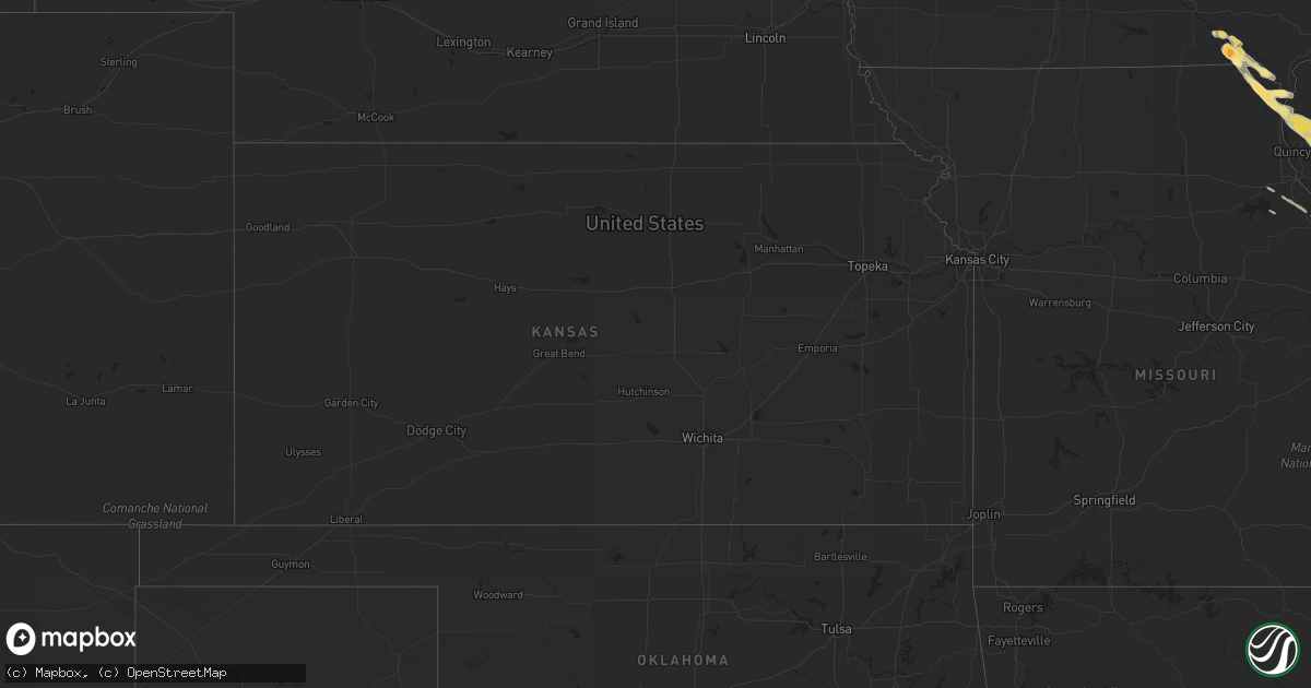
Hail Map in Iowa on April 25, 2012
Get this storm
April 25 map
$229
one time, instant access
Download today. No call, no setup
Keep the $229
Bought the map and want the full workflow? Apply the entire $229 to a subscription within 7 days. None of it is wasted.
Every map, not just this one
This buys you this map. Subscription and you get every map we run, in the markets you choose from a few cities to whole states to nationwide. Plus real-time alerts the moment a storm fires.
Contact data
Name, contact info, occupancy, even credit band for addresses in the footprint. You go from where it hit to who to call.
Become the source they trust
Unlimited branding weather history reports on demand. You already have the documented answer ready for the property owner, and you are the one who showed up with it.
Property data and RoofTrace estimates
Pull up any address you have got, its value and the exact code rules for that jurisdiction, straight from One Click Code. Then RoofTrace estimates the squares, pitch, and roof value, priced the way you price.
Storm reports in Iowa
Iowa
| Date | Description |
|---|---|
| 04/25/20126:35 PM CDT | Delayed report. |
| 04/24/20127:33 PM CDT | A local report indicates 1.75 inch wind near 2 SE CANTRIL |
| 04/24/20127:33 PM CDT | Mostly nickels falling. |
| 04/24/20127:33 PM CDT | A local report indicates 1.75 inch wind near 2 NE CANTRIL |
| 04/24/20127:30 PM CDT | Time estimated from radar. |
| 04/24/20127:17 PM CDT | Time estimated from radar...relayed by van buren sheriff office. |
All States Impacted by Hail Map on April 25, 2012
Cities Impacted by Hail Map on April 25, 2012
- Jamestown, TN
- Sunbright, TN
- Alpine, TN
- Allardt, TN
- Girard, IL
- Robbins, TN
- Helenwood, TN
- Horse Cave, KY
- Center, KY
- Hardyville, KY
- Cave City, KY
- Haviland, OH
- Scott, OH
- Payne, OH
- Convoy, OH
- Grover Hill, OH
- Cloverdale, OH
- Van Wert, OH
- Colerain, NC
- Maysville, KY
- Caneyville, KY
- Falls Of Rough, KY
- Germantown, IL
- Bartelso, IL
- Nashville, IL
- Albers, IL
- Okawville, IL
- Breese, IL
- Hoyleton, IL
- Aviston, IL
- Saint Jacob, IL
- Highland, IL
- Trenton, IL
- Glasgow, KY
- Tompkinsville, KY
- Mount Hermon, KY
- Keosauqua, IA
- Cleveland, VA
- Dante, VA
- Brownsville, KY
- Mammoth Cave, KY
- Sweeden, KY
- Cookeville, TN
- Harned, KY
- Pearl, IL
- Pittsfield, IL
- Mendon, IL
- Clayton, IL
- Liberty, IL
- Loraine, IL
- Griggsville, IL
- Chambersburg, IL
- Ursa, IL
- Fowler, IL
- Warsaw, IL
- Camp Point, IL
- Baylis, IL
- Sutter, IL
- Coatsburg, IL
- Paloma, IL
- Quincy, IL
- Corryton, TN
- Kahoka, MO
- Saint Patrick, MO
- Shipman, IL
- Chesterfield, IL
- Carlinville, IL
- Bunker Hill, IL
- Worden, IL
- Staunton, IL
- Patoka, IN
- Mooresburg, TN
- Bean Station, TN
- Pioneer, TN
- Allons, TN
- South Charleston, OH
- Central City, KY
- Whitesburg, KY
- Isom, KY
- Belle Rive, IL
- Opdyke, IL
- Mount Vernon, IL
- McLeansboro, IL
- Macedonia, IL
- Dahlgren, IL
- Butler, IL
- Litchfield, IL
- Coffeen, IL
- Hillsboro, IL
- Taylor Springs, IL
- Woodlawn, IL
- Union, KY
- Walton, KY
- Verona, KY
- Wayne City, IL
- Whitleyville, TN
- Stanton, KY
- Ridgeville, IN
- Portland, IN
- Erlanger, KY
- Hebron, KY
- Cincinnati, OH
- Sharps Chapel, TN
- Woodburn, KY
- Franklin, KY
- Milton, IA
- Cantril, IA
- Center, MO
- Perry, MO
- Wrights, IL
- Carrollton, IL
- Greenfield, IL
- White Hall, IL
- Rockbridge, IL
- Birmingham, IA
- Douds, IA
- Keyesport, IL
- Carlyle, IL
- Celina, TN
- McKee, KY
- Burnside, KY
- Canton, MO
- Wayland, MO
- Luray, MO
- Alexandria, MO
- Ewing, IL
- Dixon, KY
- Corydon, KY
- Ridgway, IL
- Robards, KY
- Waverly, KY
- Morganfield, KY
- Uniontown, KY
- Omaha, IL
- Mount Vernon, IN
- Broughton, IL
- Slaughters, KY
- Enfield, IL
- Carmi, IL
- New Haven, IL
- Sebree, KY
- Norris City, IL
- Ripley, OH
- Aberdeen, OH
- Connersville, IN
- Melbourne, KY
- New Richmond, OH
- Hawesville, KY
- Newport, KY
- Hardinsburg, KY
- Bluford, IL
- Pleasant Shade, TN
- Scottsville, KY
- Lafayette, TN
- Fountain Run, KY
- Holland, KY
- Hartsville, TN
- Gainesboro, TN
- Westmoreland, TN
- Red Boiling Springs, TN
- Adolphus, KY
- Springfield, OH
- Bowling Green, KY
- Tennyson, IN
- Boonville, IN
- Pocahontas, IL
- Bakersfield, CA
- Briceville, TN
- Etoile, KY
- Hilham, TN
- Millwood, KY
- Leitchfield, KY
- California Hot Springs, CA
- Porterville, CA
- Woody, CA
- Springville, CA
- Monroe, TN
- Moss, TN
- Byrdstown, TN
- Rugby, TN
- Gamaliel, KY
- Portland, TN
- Livingston, TN
- Huntsville, TN
- Oneida, TN
- New Trenton, IN
- Lawrenceburg, IN
- Guilford, IN
- Brookville, IN
- Laurel, IN
- Glenwood, IN
- Addyston, OH
- Sunman, IN
- Metamora, IN
- Cedar Grove, IN
- Batesville, IN
- North Bend, OH
- Harrison, OH
- Cleves, OH
- Hooven, OH
- Oldenburg, IN
- West Harrison, IN
- Rushville, IN
- Russellville, OH
- West Union, OH
- Winchester, OH
- Washington Court House, OH
- New Holland, OH
- Clarksburg, OH
- Hudson, KY
- Big Clifty, KY
- Union City, IN
- London, OH
- Palmyra, IL
- New Holland, IL
- Crossville, TN
- Richview, IL
- Winfield, TN
- Blaine, TN
- Rutledge, TN
- Evansville, IN
- Henderson, KY
- Andersonville, TN
- La Follette, TN
- Washburn, TN
- Tyner, NC
- Edenton, NC
- Hertford, NC
- Monterey, TN
- Rockwood, TN
- Velpen, IN
- Winslow, IN
- Huntingburg, IN
- Louisiana, MO
- Bowling Green, MO
- Terra Bella, CA
- Delano, CA
- Crossville, IL
- Caryville, TN
- Troy, OH
- Donnelsville, OH
- New Carlisle, OH
- Tipp City, OH
- Burlington, KY
- Fort Thomas, KY
- Ft Mitchell, KY
- Petersburg, KY
- Latonia, KY
- Bellevue, KY
- Dayton, KY
- Miamitown, OH
- Florence, KY
- Covington, KY
- Drakesboro, KY
- Centertown, KY
- Utica, KY
- Horse Branch, KY
- Reynolds Station, KY
- Stephensport, KY
- Fordsville, KY
- Cannelton, IN
- Eastview, KY
- Olaton, KY
- Maceo, KY
- Lewisport, KY
- Rome, IN
- Cloverport, KY
- Clarkson, KY
- Whitesville, KY
- McDaniels, KY
- Westview, KY
- Garfield, KY
- Tell City, IN
- New Douglas, IL
- Dorsey, IL
- Hamel, IL
- Marine, IL
- New Salem, IL
- Du Bois, IL
- Hillview, IL
- Piasa, IL
- Bethalto, IL
- Wilsonville, IL
- Alhambra, IL
- Gillespie, IL
- Moro, IL
- Roodhouse, IL
- Livingston, IL
- Medora, IL
- Patterson, IL
- New Baden, IL
- Winchester, IL
- Ashley, IL
- Edwardsville, IL
- Fidelity, IL
- Milton, IL
- Monroe, IN
- Bluffton, IN
- Berne, IN
- West Point, IL
- Perry, IL
- Hartford, KY
- Luttrell, TN
- Maynardville, TN
- Adelphi, OH
- Circleville, OH
- South Bloomingville, OH
- Laurelville, OH
- Kingston, OH
- Stoutsville, OH
- Williamsport, OH
- Amanda, OH
- Tarlton, OH
- Ashville, OH
- Orient, OH
- Mount Sterling, OH
- Dundee, KY
- Fort Recovery, OH
- Burkesville, KY
- Richland, IN
- Island, KY
- Calhoun, KY
- Mount Sterling, IA
- Arbela, MO
- Tipton, CA
- Thorn Hill, TN
- Williamsburg, KY
- Elmwood, TN
- Chestnut Mound, TN
- Carthage, TN
- Granville, TN
- Buffalo Valley, TN
- Riddleton, TN
- Silver Point, TN
- Baxter, TN
- Bloomington Springs, TN
- Crab Orchard, TN
- Vandalia, IL
- Kinmundy, IL
- Shobonier, IL
- Alma, IL
- Vernon, IL
- Saint Peter, IL
- Alvaton, KY
- Oakland City, IN
- Morristown, TN
- Russellville, TN
- Whitesburg, TN
- Bulls Gap, TN
- Bennington, IN
- Rising Sun, IN
- Brodhead, KY
- Mount Vernon, KY
- Crab Orchard, KY
- Farmington, IA
- Wise, VA
- Coeburn, VA
- Duff, TN
- Greenville, IL
- Morning View, KY
- Crittenden, KY
- Odin, IL
- Centralia, IL
- Sandoval, IL
- Lancing, TN
- Union City, OH
- New Harmony, IN
- Wadesville, IN
- Owensboro, KY
- Philpot, KY
- Glade Spring, VA
- Breeden, WV
- Dingess, WV
- Knoxville, TN
- Alexandria, KY
- Silver Grove, KY
- Bingham, IL
- Nora, VA
- Davenport, VA
- Bee, VA
- Honaker, VA
- McClure, VA
- Birchleaf, VA
- Clinchco, VA
- Selma, IA
- Bee Spring, KY
- Roundhill, KY
- Saint Paul, VA
- Pound, VA
- Fort Jennings, OH
- Felicity, OH
- Fairfield, IL
- Russia, OH
- Versailles, OH
- New London, MO
- Frankford, MO
- Auburn, KY
- Rockfield, KY
- Covington, OH
- Pleasant Hill, OH
- Laura, OH
- Versailles, IL
- Bluffs, IL
- Meredosia, IL
- Waltonville, IL
- Mouth Of Wilson, VA
- Oak Ridge, TN
- Princeton, IN
- Austin, KY
- Summer Shade, KY
- Livermore, KY
- Lincoln, IL
- Liberty, IN
- Ewing, KY
- Greensburg, KY
- Bath, IN
- Manchester, OH
- Dover, KY
- Corbin, KY
- Greenville, KY
- Lewisburg, KY
- Morgantown, KY
- Salem, IL
- Patoka, IL
- Brownstown, IL
- Mulberry Grove, IL
- Iuka, IL
- Sparta, TN
- Cynthiana, KY
- Elberfeld, IN
- Powell, TN
- Germantown, KY
- Rocky Hill, KY
- Park City, KY
- Oakland, KY
- Smiths Grove, KY
- Tazewell, TN
- Ermine, KY
- Eolia, KY
- Mayking, KY
- Carlisle, KY
- Rickman, TN
- Saint Paris, OH
- Urbana, OH
- Sadieville, KY
- Corinth, KY
- Whitley City, KY
- Pine Knot, KY
- Harriman, TN
- Sacramento, KY
- Sawyerville, IL
- Keokuk, IA
- Beaver Dam, KY
- Ina, IL
- Barry, IL
- Golden, IL
- Bonnie, IL
- Rumsey, KY
- Hanson, KY
- Mount Olive, IL
- Hettick, IL
- Bonaparte, IA
- Argyle, IA
- Bremen, KY
- Floris, IA
- Rochester, KY
- Benld, IL
- Cedar Bluff, VA
- Lebanon, VA
- Rosedale, VA
- Mason City, IL
- Derby, IN
- Chandler, IN
- Hartsburg, IL
- Stendal, IN
- California, KY
- Butler, KY
- Amelia, OH
- Middletown, IL
- Elkhart, IL
- Johnsonville, IL
- Cisne, IL
- Clinton, TN
- Sevierville, TN
- Redfox, KY
- Jeremiah, KY
- Ramsey, IL
- Timewell, IL
- Parkers Lake, KY
- Atlanta, IL
- Beason, IL
- San Jose, IL
- Raymond, IL
- Fillmore, IL
- Nilwood, IL
- Petersburg, IN
- Castlewood, VA
- Fort Branch, IN
- Haubstadt, IN
- Farina, IL
- Fletcher, OH
- Casstown, OH
- Frakes, KY
- Harvel, IL
- Nokomis, IL
- Brooksville, KY
- Independence, KY
- Grayville, IL
- Mill Shoals, IL
- Barnhill, IL
- Burnt Prairie, IL
- New Weston, OH
- Rossburg, OH
- Ansonia, OH
- Heiskell, TN
- Munfordville, KY
- Cub Run, KY
- Greensburg, IN
- Okeana, OH
- Bethel, OH
- Clintwood, VA
- Texico, IL
- Mount Sterling, IL
- Cromwell, KY
- Dix, IL
- Walnut Hill, IL
- Keenes, IL
- Kell, IL
- Sims, IL
- Norton, VA
- Louisville, IL
- Xenia, IL
- Monticello, KY
- Rose Hill, VA
- Conover, OH
- Bronston, KY
- Houston, OH
- Sidney, OH
- Piqua, OH
- Falmouth, KY
- Monroe City, MO
- Powder Springs, TN


