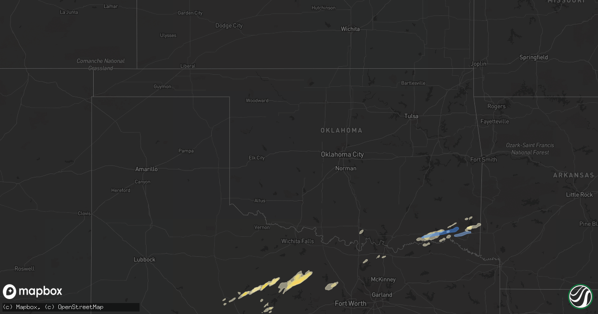
Hail Map in Oklahoma on April 24, 2022
Get this storm
April 24 map
$229
one time, instant access
Download today. No call, no setup
Keep the $229
Bought the map and want the full workflow? Apply the entire $229 to a subscription within 7 days. None of it is wasted.
Every map, not just this one
This buys you this map. Subscription and you get every map we run, in the markets you choose from a few cities to whole states to nationwide. Plus real-time alerts the moment a storm fires.
Contact data
Name, contact info, occupancy, even credit band for addresses in the footprint. You go from where it hit to who to call.
Become the source they trust
Unlimited branding weather history reports on demand. You already have the documented answer ready for the property owner, and you are the one who showed up with it.
Property data and RoofTrace estimates
Pull up any address you have got, its value and the exact code rules for that jurisdiction, straight from One Click Code. Then RoofTrace estimates the squares, pitch, and roof value, priced the way you price.
Storm reports in Oklahoma
Oklahoma
| Date | Description |
|---|---|
| 04/24/20224:05 AM CDT | At 905 PM CDT, severe thunderstorms were located along a line extending from 9 miles south of Octavia to 15 miles west of Vandervoort to 7 miles northwest of Broken Bow, moving northeast at 40 mph. HAZARD...60 mph wind gusts and penny size hail. SOURCE...Radar indicated. IMPACT...Expect damage to roofs, siding, and trees. Locations impacted include... Mena... Wickes... Grannis... Hatfield... Vandervoort... Opal... Cossatot River State Park... Polk County Fairgrounds... Mena Intermountain Airport... Mccauley... Shady... Hartley... Bard Springs Recreation Area... Caney Creek Wilderness... Cove... Acorn... Big Fork... Board Camp... Ink... Shady Lake Recreation Area... |
| 04/24/20223:59 AM CDT | At 857 PM CDT, a severe thunderstorm was located 7 miles northwest of Broken Bow, or 28 miles west of De Queen, moving northeast at 45 mph. HAZARD...60 mph wind gusts and quarter size hail. SOURCE...Radar indicated. IMPACT...Hail damage to vehicles is expected. Expect wind damage to roofs, siding, and trees. Locations impacted include... De Queen, Idabel, Broken Bow, Gillham, Garvin, Eagletown, Plunketville, Hochatown, Geneva, Watson, Mount Herman, Sherwood, Holly Creek, Glover, West Line, Bethel, Oak Hill and Golden. |
| 04/24/20222:53 AM CDT | At 753 PM CDT, severe thunderstorms were located along a line extending from 3 miles southwest of Oleta to 2 miles west of Fort Towson, moving northeast at 50 mph. HAZARD...60 mph wind gusts and quarter size hail. SOURCE...Radar indicated. IMPACT...Hail damage to vehicles is expected. Expect wind damage to roofs, siding, and trees. Locations in or near the path include... Oleta... Corinne... Sobol... |
| 04/24/20222:38 AM CDT | At 738 PM CDT, a severe thunderstorm was located 12 miles northwest of Paris, moving east at 40 mph. HAZARD...60 mph wind gusts and quarter size hail. SOURCE...Radar indicated. IMPACT...Hail damage to vehicles is expected. Expect wind damage to roofs, siding, and trees. Locations impacted include... Paris. |
| 04/24/20222:36 AM CDT | At 736 PM CDT, severe thunderstorms were located along a line extending from 5 miles west of Talihina to 2 miles southeast of Albion, moving northeast at 35 mph. HAZARD...60 mph wind gusts and penny size hail. SOURCE...Radar indicated. IMPACT...Expect damage to roofs, siding, and trees. Locations in or near the path include... Talihina... Fanshawe... Albion... Whitesboro... Talimena State Park... Summerfield... |
| 04/24/20221:41 AM CDT | At 640 PM CDT, a severe thunderstorm was located 7 miles east of Albany, moving northeast at 55 mph. HAZARD...60 mph wind gusts and quarter size hail. SOURCE...Radar indicated. IMPACT...Hail damage to vehicles is expected. Expect wind damage to roofs, siding, and trees. Locations impacted include... Albany and Wade. |
| 04/23/20229:08 PM CDT | Reports of some trees down on us highway 259 north of broken bow. |
| 04/23/20228:51 PM CDT | Reports of trees down north of glover near golden. |
| 04/23/20228:49 PM CDT | At 148 AM CDT, severe thunderstorms were located along a line extending from near Paoli to 3 miles south of Maysville to near Antioch to near Foster, moving east at 40 mph. HAZARD...60 mph wind gusts and quarter size hail. Accumulating small hail is also possible. SOURCE...Radar indicated. IMPACT...Hail damage to vehicles is expected. Expect wind damage to roofs, siding, and trees. Locations impacted include... Pauls Valley, Wynnewood, Stratford, Maysville, Roff, Elmore City, Paoli, Foster, Vanoss, Antioch and Whitebead. |
| 04/23/20228:18 PM CDT | Reports of power lines down in the pine creek area from ems. |
| 04/23/20228:16 PM CDT | At 116 AM CDT, severe thunderstorms were located along a line extending from near Alex to 7 miles east of Rush Springs to near Bray, moving east at 40 mph. HAZARD...60 mph wind gusts and quarter size hail. SOURCE...Radar indicated. IMPACT...Hail damage to vehicles is expected. Expect wind damage to roofs, siding, and trees. Locations impacted include... Marlow, Lindsay, Maysville, Bray, Elmore City, Wayne, Alex, Foster, Bradley, Antioch, Payne, Cox City, Whitebead and Erin Springs. |
| 04/23/20227:40 PM CDT | A local report indicates 60 MPH wind near 2 NW HUGO |
| 04/23/20227:21 PM CDT | Report from mping: quarter |
Cities Impacted by Hail Map on April 24, 2022
- Big Lake, TX
- Ozona, TX
- Sonora, TX
- Rocksprings, TX
- Woodson, TX
- Throckmorton, TX
- Newcastle, TX
- Hugo, OK
- Loving, TX
- Graham, TX
- Bryson, TX
- Jermyn, TX
- Jacksboro, TX
- Van Buren, MO
- Howe, TX
- Mountain Home, TX
- Harper, TX
- Junction, TX
- Dryden, TX
- Comstock, TX
- Mertzon, TX
- Arthur City, TX
- Paris, TX
- Barnhart, TX
- Fort Towson, OK
- Ringold, OK
- Valliant, OK
- Del Rio, TX
- Encinal, TX
- Breckenridge, TX
- South Bend, TX
- Garden City, TX
- Friedheim, MO
- Frohna, MO
- Oak Ridge, MO
- Uniontown, MO
- Perryville, MO
- Sherman, TX
- Avoca, TX
- Lueders, TX
- Fort Stockton, TX
- Albany, TX
- Paradise, TX
- Boyd, TX
- Springtown, TX
- Bridgeport, TX
- Moran, TX
- Cisco, TX
- Broken Bow, OK
- Eagletown, OK
- Whitesboro, TX
- Eldorado, TX
- Stamford, TX
- Anson, TX
- Ardmore, OK
- Ellsinore, MO
- Sheffield, TX
- Iraan, TX
- Tilden, TX
- Fredericktown, MO
- Poolville, TX
- Decatur, TX
- Sylvester, TX
- Boswell, OK
- Fowlerville, MI
- Webberville, MI
- Hamlin, TX
- Cotulla, TX
- Gainesville, TX
- Collinsville, TX
- Valley View, TX
- Sawyer, OK
- Grant, OK
- Watson, OK
- Grannis, AR
- Overbrook, OK
- Baird, TX
- Freer, TX
- Fremont, MO
- Allerton, IL
- Ridge Farm, IL
- Danville, IL
- Indianola, IL
- Georgetown, IL
- Sidell, IL
- Broadlands, IL
- Catlin, IL
- Bentley, MI
- Sanford, MI
- Rhodes, MI
- Beaverton, MI
- Hope, MI
- Saint Johns, MI
- Charlotte, MI
- Grand Ledge, MI
- Potterville, MI
- Bath, MI
- Ovid, MI
- Dewitt, MI
- Vermontville, MI
- Lansing, MI
- Laingsburg, MI
- Wright City, OK
- Garvin, OK
- Howell, MI
- Linden, MI
- Byron, MI
- Gaines, MI
- Fenton, MI


