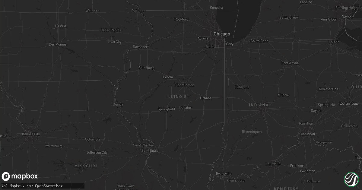
Hail Map in Illinois on April 24, 2019
Get this storm
April 24 map
$229
one time, instant access
Download today. No call, no setup
Keep the $229
Bought the map and want the full workflow? Apply the entire $229 to a subscription within 7 days. None of it is wasted.
Every map, not just this one
This buys you this map. Subscription and you get every map we run, in the markets you choose from a few cities to whole states to nationwide. Plus real-time alerts the moment a storm fires.
Contact data
Name, contact info, occupancy, even credit band for addresses in the footprint. You go from where it hit to who to call.
Become the source they trust
Unlimited branding weather history reports on demand. You already have the documented answer ready for the property owner, and you are the one who showed up with it.
Property data and RoofTrace estimates
Pull up any address you have got, its value and the exact code rules for that jurisdiction, straight from One Click Code. Then RoofTrace estimates the squares, pitch, and roof value, priced the way you price.
Storm reports in Illinois
Illinois
| Date | Description |
|---|---|
| 04/24/20193:59 PM CDT | Trees down along lackey road blown to the north. Rated ef-0 with 70 mph winds. |
| 04/24/20193:51 PM CDT | A local report indicates 1.00 inch wind near 1 E OLIVE BRANCH |
| 04/23/201910:47 PM CDT | At 347 PM CDT, a severe thunderstorm was located near Olive Branch, or 11 miles east of Scott City, moving northeast at 25 mph. HAZARD...60 mph wind gusts and quarter size hail. SOURCE...Radar indicated. IMPACT...Hail damage to vehicles is expected. Expect wind damage to roofs, siding, and trees. Locations impacted include... Tamms, Olive Branch, Ullin and Pulaski. |
| 04/23/20199:34 PM CDT | At 234 PM CDT, a severe thunderstorm was located near Advance, moving east at 20 mph. HAZARD...60 mph wind gusts and quarter size hail. SOURCE...Radar indicated. IMPACT...Hail damage to vehicles is expected. Expect wind damage to roofs, siding, and trees. Locations impacted include... Cape Girardeau, Scott City, Chaffee, Advance, Oran, Benton, Morley, Kelso, Bell City, Delta, Gordonville, Dutchtown, Leopold, Hay-Wood City, Vanduser, Blodgett, Whitewater, Allenville, Commerce and Lambert. |
All States Impacted by Hail Map on April 24, 2019
Cities Impacted by Hail Map on April 24, 2019
- Calliham, TX
- Converse, LA
- Pelican, LA
- Rockdale, TX
- Milano, TX
- Gause, TX
- Hearne, TX
- Bryan, TX
- Caldwell, TX
- Alice, TX
- Gillett, TX
- Hobson, TX
- Karnes City, TX
- Natchitoches, LA
- Three Rivers, TX
- Goliad, TX
- Provencal, LA
- Leesville, LA
- Cloutierville, LA
- Natchez, LA
- Many, LA
- Zwolle, LA
- Georgetown, LA
- Pollock, LA
- Nixon, TX
- Cost, TX
- Gonzales, TX
- D Hanis, TX
- Dryden, TX
- Rio Grande City, TX
- Hondo, TX
- George West, TX
- Hineston, LA
- Sandia, TX
- Ozona, TX
- Freer, TX
- Thebes, IL
- Olive Branch, IL
- Kenedy, TX
- Redwood, MS
- Valley Park, MS
- Vicksburg, MS
- Castor, LA
- San Augustine, TX
- Zavalla, TX
- Broaddus, TX
- Roma, TX
- Medina, TX
- Kerrville, TX
- Comfort, TX
- Mertzon, TX
- Christoval, TX
- Boerne, TX
- Leakey, TX
- Anahuac, TX
- Yorktown, TX
- Brackettville, TX
- Horseshoe Bay, TX
- Marble Falls, TX
- Beeville, TX
- Dequincy, LA
- Pitkin, LA
- Utopia, TX
- Eldorado, TX
- San Angelo, TX
- Round Mountain, TX
- Johnson City, TX
- College Station, TX
- Cameron, TX
- Blanco, TX
- Cuero, TX
- Fredericksburg, TX
- Deridder, LA
- Iola, TX
- Bedias, TX
- Longville, LA
- Wimberley, TX
- Dripping Springs, TX
- Boyce, LA
- Sieper, LA
- Bronson, TX
- Orange Grove, TX
- Taylor, TX
- Shelbyville, TX
- Willow City, TX
- San Diego, TX
- Victoria, TX
- Refugio, TX
- Tilden, TX
- Trout, LA
- North Zulch, TX
- Madisonville, TX
- Normangee, TX
- Del Rio, TX
- Center, TX
- Hemphill, TX
- Granger, TX
- Singer, LA
- Waelder, TX
- Thrall, TX
- Kendalia, TX
- Spring Branch, TX
- Call, TX
- Mathis, TX
- Coushatta, LA
- Thorndale, TX
- Ecleto, TX
- Nordheim, TX
- Runge, TX
- Forest Hill, LA
- Buckholts, TX
- Davilla, TX
- Milam, TX
- Belmont, LA
- Merryville, LA
- Starks, LA
- Stockdale, TX
- Tamms, IL
- Ruston, LA
- Choudrant, LA
- Leander, TX
- Georgetown, TX
- Liberty Hill, TX


