Hail Map in Minnesota on April 23, 2026
The weather event in Minnesota on April 23, 2026 includes Hail, Wind, and Tornado maps. 9 states and 935 cities were impacted and suffered possible damage. The total estimated number of properties impacted is 9,270.
Want more than just the map?
Turn this storm into a full workflow.
- Owner + property data so you know who to knock
- OnDemand branded weather history reports to win the "did we even have hail?" argument
- RoofTrace estimate so reps stop guessing numbers at the door
Bought this map? Upgrade within 7 days and we'll credit the $230. (10-15 min setup call)
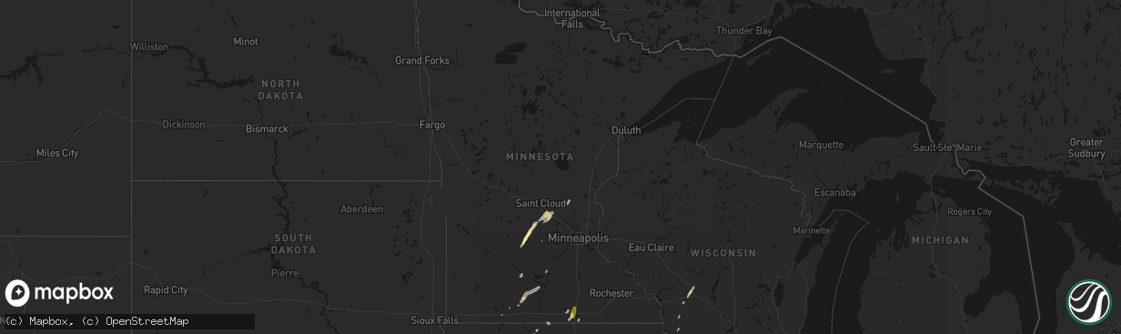
Hail
Wind
Tornado
9,270
Estimated number of impacted properties by a 1.00" hail or larger0
Estimated number of impacted properties by a 1.75" hail or larger0
Estimated number of impacted properties by a 2.50" hail or largerStorm reports in Minnesota
Minnesota
| Date | Description |
|---|---|
| 04/23/20266:44 PM CDT | A local report indicates 1.00 inch wind near Albert Lea |
| 04/23/20266:39 PM CDT | Awos station kael albert lea ap. |
| 04/23/20262:53 PM CDT | Trained spotter phoned in hail measurement. |
All States Impacted by Hail Map on April 23, 2026
Cities Impacted by Hail Map on April 23, 2026
- Schuyler, NE
- Dodge, NE
- Scribner, NE
- North Bend, NE
- Rogers, NE
- Winnebago, NE
- Thurston, NE
- Emerson, NE
- Hubbard, NE
- Homer, NE
- Hooper, NE
- West Point, NE
- Sergeant Bluff, IA
- Oakland, NE
- Salix, IA
- Sioux City, IA
- Dwight, NE
- Valparaiso, NE
- Lawton, IA
- Bronson, IA
- Craig, NE
- Uehling, NE
- Fremont, NE
- Nickerson, NE
- Winslow, NE
- Tekamah, NE
- Herman, NE
- Moville, IA
- Blencoe, IA
- Little Sioux, IA
- Mead, NE
- Kingsley, IA
- Onawa, IA
- Pisgah, IA
- Yutan, NE
- Valley, NE
- Moorhead, IA
- Mondamin, IA
- Wahoo, NE
- Bennington, NE
- Arlington, NE
- Kennard, NE
- Soldier, IA
- Marcus, IA
- Pierson, IA
- Fairbury, NE
- Anthon, IA
- Correctionville, IA
- Narka, KS
- Pleasant Dale, NE
- Milford, NE
- Ute, IA
- Denton, NE
- Lincoln, NE
- Jansen, NE
- Davey, NE
- Raymond, NE
- Blair, NE
- Ceresco, NE
- Malcolm, NE
- Cedar Bluffs, NE
- Crete, NE
- Haddam, KS
- Mahaska, KS
- Seward, NE
- Garland, NE
- Woodbine, IA
- Dunlap, IA
- Washta, IA
- Fort Calhoun, NE
- Missouri Valley, IA
- Morrowville, KS
- Elkhorn, NE
- Waterloo, NE
- Modale, IA
- Logan, IA
- Stewart, MN
- Cosmos, MN
- Buffalo Lake, MN
- Dow City, IA
- Charter Oak, IA
- Hutchinson, MN
- Litchfield, MN
- Darwin, MN
- Endicott, NE
- Ashland, NE
- Waverly, NE
- Plymouth, NE
- Martell, NE
- Washington, NE
- Beatrice, NE
- Magnolia, IA
- Holstein, IA
- Cushing, IA
- Denison, IA
- Dassel, MN
- Greenwood, NE
- Arion, IA
- Omaha, NE
- Diller, NE
- Gretna, NE
- Cherokee, IA
- Aurelia, IA
- Quimby, IA
- Alta, IA
- Battle Creek, IA
- Danbury, IA
- Mapleton, IA
- Crescent, IA
- De Witt, NE
- Pickrell, NE
- Peterson, IA
- Honey Creek, IA
- South Haven, MN
- Kimball, MN
- Panama, IA
- Earling, IA
- Springfield, NE
- Rembrandt, IA
- Storm Lake, IA
- La Vista, NE
- Papillion, NE
- Defiance, IA
- Manilla, IA
- Washington, KS
- Wymore, NE
- Blue Springs, NE
- Sioux Rapids, IA
- Linn Grove, IA
- Schleswig, IA
- Ida Grove, IA
- Vail, IA
- Carter Lake, IA
- Council Bluffs, IA
- Gypsum, KS
- Assaria, KS
- Hollenberg, KS
- Virginia, NE
- Neola, IA
- Deloit, IA
- Filley, NE
- Webb, IA
- Greenville, IA
- New Ulm, MN
- Sleepy Eye, MN
- Silver Lake, MN
- Annandale, MN
- Odell, NE
- Adams, NE
- Hutchinson, KS
- Persia, IA
- Portsmouth, IA
- Kiron, IA
- Buhler, KS
- Westside, IA
- Galva, IA
- Abilene, KS
- Hanover, KS
- Tecumseh, NE
- Underwood, IA
- Maple Lake, MN
- Clearwater, MN
- Crab Orchard, NE
- Sterling, NE
- Lewiston, NE
- Saint Peter, MN
- Marathon, IA
- Galva, KS
- Canton, KS
- Mcpherson, KS
- Inman, KS
- Monticello, MN
- Clear Lake, MN
- Bremen, KS
- Moundridge, KS
- Albert City, IA
- Jackson, MN
- Breda, IA
- Arcadia, IA
- Cook, NE
- Hope, KS
- Wall Lake, IA
- Shelby, IA
- Becker, MN
- Enterprise, KS
- Chapman, KS
- Westphalia, IA
- Harlan, IA
- Kirkman, IA
- Avoca, IA
- Irwin, IA
- Liberty, NE
- Humboldt, NE
- Lake View, IA
- Auburn, IA
- Treynor, IA
- McClelland, IA
- Minden, IA
- Ayrshire, IA
- Malvern, IA
- Hastings, IA
- Randolph, IA
- Burchard, NE
- Brock, NE
- Johnson, NE
- Talmage, NE
- Carroll, IA
- Manning, IA
- Elk Horn, IA
- Walnut, IA
- Exira, IA
- Kimballton, IA
- Audubon, IA
- Gray, IA
- Julian, NE
- Nebraska City, NE
- Emmetsburg, IA
- Tampa, KS
- Lehigh, KS
- Hillsboro, KS
- Emerson, IA
- Imogene, IA
- Durham, KS
- Roxbury, KS
- Woodbine, KS
- Auburn, NE
- Lytton, IA
- Rockwell City, IA
- Aspinwall, IA
- Hancock, IA
- Oakland, IA
- Barneston, NE
- Steinauer, NE
- Laurens, IA
- Curlew, IA
- Home, KS
- Marysville, KS
- Peabody, KS
- Newton, KS
- Marion, KS
- Templeton, IA
- Pawnee City, NE
- Table Rock, NE
- Herington, KS
- Ramona, KS
- Cylinder, IA
- Princeton, MN
- Oketo, KS
- Beattie, KS
- Summerfield, KS
- Dunbar, NE
- Lorton, NE
- Elk Creek, NE
- Blue Rapids, KS
- Frankfort, KS
- Peru, NE
- Junction City, KS
- Henderson, IA
- Carson, IA
- Florence, KS
- Lake City, IA
- Fort Riley, KS
- Riley, KS
- Dwight, KS
- Silver City, IA
- Marne, IA
- Atlantic, IA
- Brayton, IA
- Hamlin, IA
- White City, KS
- Lincolnville, KS
- Manson, IA
- Somers, IA
- Barnum, IA
- Trimont, MN
- Dedham, IA
- Hamburg, IA
- Macedonia, IA
- Whittemore, IA
- Fenton, IA
- Saint James, MN
- Halbur, IA
- Ogden, KS
- Lost Springs, KS
- Truman, MN
- Ormsby, MN
- Manhattan, KS
- Burdick, KS
- Council Grove, KS
- Clare, IA
- Lewis, IA
- Wiota, IA
- Anita, IA
- Riverton, IA
- Caldwell, KS
- Mayfield, KS
- Wellington, KS
- Griswold, IA
- Sidney, IA
- Madelia, MN
- Bancroft, IA
- Lone Rock, IA
- Glidden, IA
- Coon Rapids, IA
- Medford, OK
- Alta Vista, KS
- Du Bois, NE
- Percival, IA
- Rock Port, MO
- Baileyville, KS
- Axtell, KS
- Thurman, IA
- Knierim, IA
- Ralston, IA
- Scranton, IA
- Rutland, IA
- Bradgate, IA
- Elmdale, KS
- Cedar Point, KS
- Vermillion, KS
- Wilsey, KS
- Milan, KS
- Alma, KS
- Cumberland, IA
- Farnhamville, IA
- Nemaha, NE
- Farragut, IA
- Brownville, NE
- Watson, MO
- Adair, IA
- Guthrie Center, IA
- Swea City, IA
- Bode, IA
- Moorland, IA
- Lohrville, IA
- Strong City, KS
- Soldiers Grove, WI
- Gays Mills, WI
- Ottosen, IA
- Lake Crystal, MN
- Churdan, IA
- Fort Dodge, IA
- Eskridge, KS
- Bern, KS
- Gowrie, IA
- Dawson, NE
- Verdon, NE
- Stella, NE
- Jefferson, IA
- Bayard, IA
- Bagley, IA
- Elmore, MN
- Buffalo Center, IA
- Shenandoah, IA
- Walton, KS
- Elliott, IA
- Red Oak, IA
- Tarkio, MO
- Shubert, NE
- Essex, IA
- Callender, IA
- Westboro, MO
- Paton, IA
- Algona, IA
- McFarland, KS
- Maple Hill, KS
- Paxico, KS
- Topeka, KS
- Dana, IA
- Grand Junction, IA
- Sabetha, KS
- Seneca, KS
- Viroqua, WI
- Whitewater, KS
- Burns, KS
- Elbing, KS
- Badger, IA
- Coin, IA
- Northboro, IA
- Frost, MN
- Salem, NE
- Emporia, KS
- Harveyville, KS
- Americus, KS
- Allen, KS
- Auburn, KS
- Silver Lake, KS
- Rossville, KS
- Braman, OK
- Nardin, OK
- Dayton, IA
- Ogden, IA
- Bridgewater, IA
- Otho, IA
- Stanton, IA
- Villisca, IA
- Walker, IA
- Central City, IA
- Center Point, IA
- Jamaica, IA
- Menlo, IA
- Casey, IA
- Panora, IA
- Clarinda, IA
- Yorktown, IA
- Duncombe, IA
- Webster City, IA
- Fairfax, MO
- Massena, IA
- Albert Lea, MN
- Clarks Grove, MN
- Glenville, MN
- Yale, IA
- Linden, IA
- Craig, MO
- Pilot Mound, IA
- Perry, IA
- Rippey, IA
- Boxholm, IA
- Dawson, IA
- Beaver, IA
- Fontanelle, IA
- Greenfield, IA
- Alburnett, IA
- Coggon, IA
- Cottonwood Falls, KS
- Lehigh, IA
- Stratford, IA
- Alden, MN
- Redfield, IA
- Falls City, NE
- Emmons, MN
- Twin Lakes, MN
- New Market, IA
- Minburn, IA
- Bouton, IA
- Dallas Center, IA
- Woodward, IA
- Deer Creek, OK
- Granger, IA
- Madrid, IA
- Masonville, IA
- Ryan, IA
- Stuart, IA
- Boone, IA
- Skidmore, MO
- Mound City, MO
- South Haven, KS
- Rose Hill, IA
- Delta, IA
- Blackwell, OK
- Gravity, IA
- Nodaway, IA
- Admire, KS
- Reading, KS
- Osage City, KS
- Burlingame, KS
- Tecumseh, KS
- Winterset, IA
- Winthrop, IA
- Stanhope, IA
- Bloomfield, IA
- Maitland, MO
- Bedford, IA
- Earlham, IA
- Adel, IA
- Dexter, IA
- Hopkins, MO
- Newkirk, OK
- Guernsey, IA
- Gibson, IA
- Keswick, IA
- Deep River, IA
- Slater, IA
- Kelley, IA
- Huxley, IA
- Polk City, IA
- Johnston, IA
- Grimes, IA
- Ankeny, IA
- Elkhart, IA
- Sheldahl, IA
- Alleman, IA
- Cambridge, IA
- Manchester, IA
- De Soto, IA
- Van Meter, IA
- Pond Creek, OK
- What Cheer, IA
- Victor, IA
- Lamont, OK
- Geuda Springs, KS
- Potwin, KS
- Valley Center, KS
- Drummond, OK
- Lecompton, KS
- Grantville, KS
- Perry, KS
- Berryton, KS
- Lawrence, KS
- Scranton, KS
- Carbondale, KS
- Lyndon, KS
- Lebo, KS
- Melvern, KS
- Waukomis, OK
- Lahoma, OK
- Enid, OK
- West Des Moines, IA
- Waukee, IA
- Palo, IA
- Cedar Rapids, IA
- Hiawatha, IA
- Robins, IA
- Marion, IA
- Wichita, KS
- Floris, IA
- Urbandale, IA
- Sheridan, MO
- Ames, IA
- Agency, IA
- Batavia, IA
- Eldon, IA
- Clive, IA
- Ottumwa, IA
- Benton, KS
- Kechi, KS
- Fairfax, IA
- Norway, IA
- Atkins, IA
- Booneville, IA
- Cumming, IA
- Des Moines, IA
- Windsor Heights, IA
- Norwalk, IA
- Carlisle, IA
- Pleasant Hill, IA
- Altoona, IA
- Runnells, IA
- Sparta, WI
- Norwalk, WI
- Diagonal, IA
- Shannon City, IA
- Toddville, IA
- Towanda, KS
- Greenwich, KS
- Hedrick, IA
- Packwood, IA
- Blockton, IA
- Arkansas City, KS
- Hunter, OK
- Ponca City, OK
- Vassar, KS
- Baldwin City, KS
- Ottawa, KS
- Quenemo, KS
- Pomona, KS
- Wellsville, KS
- Overbrook, KS
- Oskaloosa, KS
- Andover, KS
- Augusta, KS
- Hartford, IA
- Prairie City, IA
- Swan, IA
- Mitchellville, IA
- Colfax, IA
- Monroe, IA
- El Dorado, KS
- Afton, IA
- Keota, IA
- Ollie, IA
- Richland, IA
- Swisher, IA
- Warrens, WI
- Tomah, WI
- Fairmont, OK
- Maryville, MO
- Pickering, MO
- Fairfield, IA
- Faxon, OK
- Cache, OK
- Cassoday, KS
- Matfield Green, KS
- Olpe, KS
- Madison, KS
- Lawton, OK
- Rose Hill, KS
- Westby, WI
- Amana, IA
- Kaw City, OK
- Leavenworth, KS
- Eureka, KS
- Eudora, KS
- Edgerton, KS
- Gardner, KS
- Spring Hill, KS
- Paola, KS
- Olathe, KS
- Linwood, KS
- New Century, KS
- Tonganoxie, KS
- De Soto, KS
- Shawnee, KS
- McLouth, KS
- Basehor, KS
- Kansas City, KS
- Lenexa, KS
- Bonner Springs, KS
- Lamoni, IA
- Kellerton, IA
- Davis City, IA
- Grand River, IA
- Decatur, IA
- Leon, IA
- Garden Grove, IA
- Lineville, IA
- Allerton, IA
- Corydon, IA
- Humeston, IA
- Leon, KS
- Ames, OK
- Bison, OK
- Douglas, OK
- Brighton, IA
- Tonkawa, OK
- Shidler, OK
- Osceola, IA
- Weldon, IA
- Newton, IA
- Delhi, IA
- Eagleville, MO
- Hatfield, MO
- Mount Ayr, IA
- Blythedale, MO
- Bucyrus, KS
- Raymore, MO
- Prairie Village, KS
- Grandview, MO
- Stilwell, KS
- Belton, MO
- Leawood, KS
- Mission, KS
- Overland Park, KS
- Kansas City, MO
- Independence, MO
- Liberty, MO
- Riverside, MO
- Lees Summit, MO
- Kearney, MO
- Holt, MO
- Riverside, IA
- Burbank, OK
- Anamosa, IA
- Covington, OK
- Washington, IA
- Ainsworth, IA
- Lone Tree, IA
- Iowa City, IA
- West Liberty, IA
- West Branch, IA
- Marshall, OK
- Buckner, MO
- Orrick, MO
- Missouri City, MO
- Excelsior Springs, MO
- Lawson, MO
- Blue Springs, MO
- Polo, MO
- Sibley, MO
- Rayville, MO
- Lathrop, MO
- Lucien, OK
- Holy Cross, IA
- Sherrill, IA
- North Buena Vista, IA
- Solon, IA
- Springville, IA
- Mount Vernon, IA
- Woodburn, IA
- Van Wert, IA
- Derby, IA
- Chariton, IA
- Lucas, IA
- Millerton, IA
- Cassville, WI
- Potosi, WI
- Lancaster, WI
- Bloomington, WI
- Rantoul, KS
- Perry, OK
- Mechanicsville, IA
- Richmond, MO
- Wellington, MO
- Greenwood, MO
- Kingsville, MO
- Lexington, MO
- Henrietta, MO
- Centerview, MO
- Odessa, MO
- Bates City, MO
- Mayview, MO
- Lone Jack, MO
- Oak Grove, MO
- Pleasant Hill, MO
- Grain Valley, MO
- Camden, MO
- Levasy, MO
- Napoleon, MO
- Holden, MO
- Higginsville, MO
- Ludlow, MO
- Norborne, MO
- Dawn, MO
- Warrensburg, MO
- Braymer, MO
- Dover, MO
- Hardin, MO
- Cowgill, MO
- Carrollton, MO
- Bogard, MO
- Pawhuska, OK
- Breckenridge, MO
- Lisbon, IA
- Waldron, MO
- Smithville, MO
- Lansing, KS
- Platte City, MO
- Garber, OK
- Monticello, IA
- Hopkinton, IA
- Center Junction, IA
- Hale, MO
- Chillicothe, MO
- Tina, MO
- Martelle, IA
- Stillwater, OK
- Morrison, OK
- Waverly, MO
- Alma, MO
- Malta Bend, MO
- Corder, MO
- Livingston, WI
- Blackburn, MO
- Montfort, WI
- Platteville, WI
- Cobb, WI
- Cleveland, MO
- Louisburg, KS
- Freeman, MO
- Peculiar, MO
- Harrisonville, MO
- Fredonia, KS
- Fall River, KS
- Wakarusa, KS
- Cascade, IA
- Onslow, IA
- Monmouth, IA
- Bernard, IA
- Baldwin, IA
- Orlando, OK
- Glencoe, OK
- Bosworth, MO
- Miami, MO
- Brunswick, MO
- Triplett, MO
- De Witt, MO
- Fairfax, OK
- Buffalo, KS
- Toronto, KS
- Pawnee, OK
- Zwingle, IA
- Mendon, MO
- Sumner, MO
- Meadville, MO
- Brookfield, MO
- Wynona, OK
- Bartlesville, OK
- Dewey, OK
- La Motte, IA
- Bellevue, IA
- Webster, IA
- Delaware, OK
- Wann, OK
- Lenapah, OK
- Red Rock, OK
- Maramec, OK
- Cleveland, OK
- Hominy, OK
- Nowata, OK
- Bluejacket, OK
- Welch, OK
- Vinita, OK
- S Coffeyville, OK
- Barnsdall, OK
- Osage, OK
- Ochelata, OK
- Skiatook, OK
- Sigourney, IA
- Harper, IA
- South English, IA
- North English, IA
- West Chester, IA
- Wellman, IA
- Ladora, IA
- Parnell, IA
- Marengo, IA
- Millersburg, IA
- Williamsburg, IA
- Kalona, IA
- Oxford, IA
- Nichols, IA
- Columbus Junction, IA
- Tiffin, IA
- North Liberty, IA
- Coralville, IA
- South Amana, IA
- Homestead, IA
- Hills, IA
- Tipton, IA
- Ramona, OK
- Collinsville, OK
- Talala, OK
- Vera, OK
- Hennessey, OK
- Jennings, OK
- Yale, OK
- Mulhall, OK
- Terlton, OK
- Kingfisher, OK
- Oologah, OK
- Mannford, OK
- Prue, OK
- Big Cabin, OK
- Clarence, IA
- Stanwood, IA
- Bennett, IA
- Wheatland, IA
- Lowden, IA
- Calamus, IA
- Grand Mound, IA
- Sand Springs, OK
- Sperry, OK
- Dover, OK
- Miami, OK
- Commerce, OK
- Picher, OK
- Quapaw, OK
- North Miami, OK
- Baxter Springs, KS
- Galena, KS
- Riverton, KS
- Treece, KS
- Chetopa, KS
- Columbus, KS
- Crescent, OK
- Tulsa, OK
- Joplin, MO
- Seneca, MO
- Duenweg, MO
- Webb City, MO
- Carthage, MO
- Sapulpa, OK
- Cashion, OK
- Guthrie, OK
- Okarche, OK
- Broken Arrow, OK
- Edmond, OK
- Rose, OK
- Tahlequah, OK
- Kansas, OK
- Watts, OK
- Westville, OK
- Proctor, OK
- Wagoner, OK
- Porter, OK
- Fort Gibson, OK
- Hulbert, OK
- Park Hill, OK
- Welling, OK
- Bunch, OK
- Cookson, OK
- Stanberry, MO
- Sallisaw, OK
- Cedarville, AR
- Marland, OK
- Drury, MO
- Dora, MO
- Vanzant, MO
- Brixey, MO
- Zanoni, MO
- West Plains, MO
- Pottersville, MO
- Pomona, MO
- Rudy, AR
- Van Buren, AR
- Willow Springs, MO
- Alma, AR
- Oregon, MO
- Rulo, NE
- Burlington, KS
- Gridley, KS
- Westphalia, KS
- La Cygne, KS
- Parker, KS
- Adrian, MO
- Butler, MO
- Trimble, MO
- Plattsburg, MO
- Purdin, MO
- Linneus, MO
- Laclede, MO
- New Boston, MO
- Wheeling, MO
- Utica, MO
- Mooresville, MO
- Bucklin, MO
- Rothville, MO
- Marceline, MO
- Winigan, MO
- Browning, MO
- Eldridge, IA
- Bettendorf, IA
- Davenport, IA
- New Liberty, IA
- Stockton, IA
- Walcott, IA
- Durant, IA
- Dixon, IA
- Wilton, IA
- Preston, IA
- Miles, IA
- Sabula, IA
- Lena, IL
- Stockton, IL


