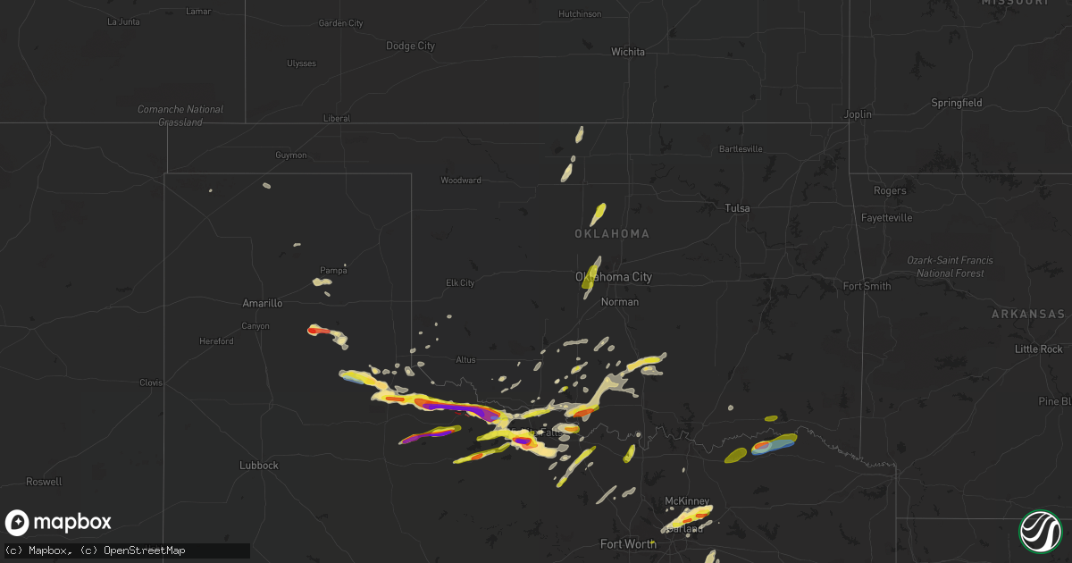
Hail Map in Oklahoma on April 23, 2021
Get this storm
April 23 map
$229
one time, instant access
Download today. No call, no setup
Keep the $229
Bought the map and want the full workflow? Apply the entire $229 to a subscription within 7 days. None of it is wasted.
Every map, not just this one
This buys you this map. Subscription and you get every map we run, in the markets you choose from a few cities to whole states to nationwide. Plus real-time alerts the moment a storm fires.
Contact data
Name, contact info, occupancy, even credit band for addresses in the footprint. You go from where it hit to who to call.
Become the source they trust
Unlimited branding weather history reports on demand. You already have the documented answer ready for the property owner, and you are the one who showed up with it.
Property data and RoofTrace estimates
Pull up any address you have got, its value and the exact code rules for that jurisdiction, straight from One Click Code. Then RoofTrace estimates the squares, pitch, and roof value, priced the way you price.
Storm reports in Oklahoma
Oklahoma
| Date | Description |
|---|---|
| 04/23/20214:56 PM CDT | Mping |
| 04/23/20214:53 PM CDT | Mping. |
| 04/23/20214:52 PM CDT | Nickel to quarter hail. |
| 04/23/20214:37 PM CDT | Mping |
| 04/23/20211:31 PM CDT | A local report indicates 1.00 inch wind near 2 SW LAWTON |
| 04/23/20214:44 AM CDT | At 944 PM CDT, a severe thunderstorm was located 5 miles northwest of Bellevue, moving east at 30 mph. HAZARD...Golf ball size hail and 60 mph wind gusts. SOURCE...Radar indicated. IMPACT...People and animals outdoors will be injured. Expect hail damage to roofs, siding, windows, and vehicles. Expect wind damage to roofs, siding, and trees. Locations impacted include... Henrietta, Bellevue, Bluegrove, Vashti and Joy. |
| 04/23/20214:40 AM CDT | At 937 PM CDT, severe thunderstorms were located along a line extending from near Oscar to near Bluegrove, moving east at 35 mph. HAZARD...60 mph wind gusts and quarter size hail. SOURCE...Radar indicated. IMPACT...Hail damage to vehicles is expected. Expect wind damage to roofs, siding, and trees. Locations impacted include... Bowie, Nocona, St. Jo, Stoneburg and Sunset. |
| 04/23/20214:12 AM CDT | At 912 PM CDT, severe thunderstorms were located along a line extending from near Loco to 5 miles southwest of Ringling to 4 miles west of Terral, moving east at 50 mph. HAZARD...Ping pong ball size hail and 60 mph wind gusts. SOURCE...Radar indicated. IMPACT...People and animals outdoors will be injured. Expect hail damage to roofs, siding, windows, and vehicles. Expect wind damage to roofs, siding, and trees. Locations impacted include... Lone Grove, Healdton, Wilson, Ringling, Ryan, Terral, Loco, Ratliff City, Leon, Graham, Pooleville, Rubottom, Burneyville, Grady, Milo, Oscar, Cornish, Fox, Courtney and Petersburg. |
| 04/23/20214:12 AM CDT | At 912 PM CDT, a severe thunderstorm was located 10 miles north of Honey Grove, or 19 miles northeast of Bonham, moving northeast at 35 mph. HAZARD...60 mph wind gusts and nickel size hail. SOURCE...Radar indicated. IMPACT...Expect damage to roofs, siding, and trees. Locations impacted include... Paris, Honey Grove, Windom and Toco. |
| 04/23/20214:02 AM CDT | At 902 PM CDT, a severe thunderstorm was located 4 miles northwest of Lake Arrowhead, moving east at 30 mph. HAZARD...Golf ball size hail and 60 mph wind gusts. SOURCE...Radar indicated. IMPACT...People and animals outdoors will be injured. Expect hail damage to roofs, siding, windows, and vehicles. Expect wind damage to roofs, siding, and trees. Locations impacted include... Henrietta, Scotland, Windthorst, Terral, Bellevue, Jolly, Newport, Lake Arrowhead, Bluegrove, Joy and Vashti. |
| 04/23/20213:36 AM CDT | At 836 PM CDT, severe thunderstorms were located along a line extending from 3 miles southeast of Duncan to 4 miles south of Hastings, moving east at 40 mph. HAZARD...60 mph wind gusts and quarter size hail. SOURCE...Radar indicated. IMPACT...Hail damage to vehicles is expected. Expect wind damage to roofs, siding, and trees. Locations impacted include... Duncan, Waurika, Comanche, Hastings, Loco, Addington and Waurika Lake. |
| 04/23/20213:24 AM CDT | At 823 PM CDT, severe thunderstorms were located along a line extending from 4 miles southeast of Agawam to 5 miles southeast of Duncan, moving east at 30 mph. HAZARD...60 mph wind gusts and quarter size hail. SOURCE...Radar indicated. IMPACT...Hail damage to vehicles is expected. Expect wind damage to roofs, siding, and trees. Locations impacted include... Duncan, Marlow, Lindsay, Rush Springs, Bray, Velma, Alex, Bradley, Agawam, Cox City and Erin Springs. |
| 04/23/20212:52 AM CDT | At 752 PM CDT, a severe thunderstorm was located near Burkburnett, moving east at 25 mph. HAZARD...60 mph wind gusts and quarter size hail. SOURCE...Radar indicated. IMPACT...Hail damage to vehicles is expected. Expect wind damage to roofs, siding, and trees. Locations impacted include... Burkburnett, Sheppard AFB and Cashion. |
| 04/23/20212:06 AM CDT | At 705 PM CDT, a severe thunderstorm was located 8 miles northeast of Kirkland, moving east at 25 mph. HAZARD...60 mph wind gusts and quarter size hail. SOURCE...Radar indicated. IMPACT...Hail damage to vehicles is expected. Expect wind damage to roofs, siding, and trees. Locations impacted include... Quanah and Eldorado. |
| 04/23/20211:30 AM CDT | At 630 PM CDT, a severe thunderstorm was located 4 miles southeast of Manitou, moving east at 50 mph. HAZARD...60 mph wind gusts and quarter size hail. SOURCE...Radar indicated. IMPACT...Hail damage to vehicles is expected. Expect wind damage to roofs, siding, and trees. Locations impacted include... Lawton, Frederick, Cache, Geronimo, Chattanooga, Medicine Park, Indiahoma, Manitou, Faxon, Hollister, Meers, Fort Sill, Lake Lawtonka and Wichita Mountains Wildlife Refuge. |
| 04/23/20211:13 AM CDT | At 612 PM CDT, a severe thunderstorm was located near Hillsdale, moving northeast at 30 mph. HAZARD...Quarter size hail. SOURCE...Radar indicated. IMPACT...Damage to vehicles is expected. Locations impacted include... Pond Creek, Goltry, Nash, Hillsdale, Carrier and Jefferson. |
| 04/23/20211:06 AM CDT | Trees down county wide. Four different instances of trees on houses near broken bow... South of idabel... And near wright city. |
| 04/22/202111:42 PM CDT | At 442 PM CDT, a severe thunderstorm was located over southwestern Oklahoma City, or 4 miles west of Mustang, moving northeast at 45 mph. HAZARD...Quarter size hail. SOURCE...Radar indicated. IMPACT...Damage to vehicles is expected. Locations impacted include... Western Oklahoma City, western Edmond, El Reno, Yukon, Bethany, Mustang, Warr Acres, The Village, Tuttle, Piedmont, Nichols Hills, Union City, Minco, Woodlawn Park and Richland. |
| 04/22/202110:05 PM CDT | At 305 PM CDT, a severe thunderstorm was located 4 miles northwest of Ringling, moving northeast at 50 mph. HAZARD...60 mph wind gusts and quarter size hail. SOURCE...Radar indicated. IMPACT...Hail damage to vehicles is expected. Expect wind damage to roofs, siding, and trees. Locations impacted include... Healdton, Wilson, Ringling, Velma, Tatums, Loco, Ratliff City, Graham, Pooleville, Milo, Cornish, Fox and Pernell. |
| 04/22/20219:42 PM CDT | At 242 PM CDT, a severe thunderstorm was located over Stoneburg, or near Bowie, moving northeast at 30 mph. HAZARD...Quarter size hail. SOURCE...Radar indicated. IMPACT...Damage to vehicles is possible. Locations impacted include... Bowie, Nocona, St. Jo and Stoneburg. |
| 04/22/20219:18 PM CDT | A local report indicates 1.00 inch wind near 1 SSW RYAN |
| 04/22/20218:56 PM CDT | A local report indicates 60 MPH wind near 1 NW MEERS |
| 04/22/20218:26 PM CDT | A local report indicates 1.25 inch wind near CORUM |
All States Impacted by Hail Map on April 23, 2021
Cities Impacted by Hail Map on April 23, 2021
- Groom, TX
- Foster, OK
- Duncan, OK
- Memphis, TX
- Childress, TX
- Seymour, TX
- Crowell, TX
- Willis, TX
- San Saba, TX
- Paducah, TX
- Quanah, TX
- Howe, TX
- Oklaunion, TX
- Harrold, TX
- Shepherd, TX
- Coldspring, TX
- Cleveland, TX
- Electra, TX
- Iowa Park, TX
- Vernon, TX
- Lawton, OK
- Faxon, OK
- Jena, LA
- Hico, TX
- Hamilton, TX
- Comanche, TX
- Iredell, TX
- Carlton, TX
- Gustine, TX
- Dublin, TX
- Copperas Cove, TX
- Tylertown, MS
- Spurger, TX
- Fred, TX
- Silsbee, TX
- Richardson, TX
- Farmersville, TX
- Plano, TX
- Wylie, TX
- Garland, TX
- Nevada, TX
- Allen, TX
- Princeton, TX
- Jbsa Lackland, TX
- San Antonio, TX
- Morgan, TX
- Meridian, TX
- Sumner, TX
- Arthur City, TX
- Brookston, TX
- Lampasas, TX
- Holliday, TX
- Wichita Falls, TX
- Henrietta, TX
- Bogalusa, LA
- Franklinton, LA
- Bunkie, LA
- Tell, TX
- Damon, TX
- New Waverly, TX
- Montgomery, TX
- Ringling, OK
- Graham, OK
- Ryan, OK
- Loco, OK
- Waurika, OK
- Ratliff City, OK
- Gould, OK
- Rockwall, TX
- Deridder, LA
- Temple, OK
- Randlett, OK
- Claude, TX
- Warren, TX
- Woodville, TX
- Whatley, AL
- Grove Hill, AL
- Leroy, AL
- Jackson, AL
- Wagarville, AL
- Frisco City, AL
- Gainestown, AL
- White Deer, TX
- Scurry, TX
- Terrell, TX
- Kaufman, TX
- Ennis, TX
- Walters, OK
- Lumberton, MS
- Columbia, MS
- Crystal City, TX
- Caney, OK
- Bennington, OK
- Caddo, OK
- Petrolia, TX
- Beeville, TX
- Lavon, TX
- Mansura, LA
- Jonesville, LA
- Deville, LA
- Three Rivers, TX
- Campbellton, TX
- Kenedy, TX
- Jourdanton, TX
- Refugio, TX
- Fruitdale, AL
- Vinegar Bend, AL
- State Line, MS
- Kentwood, LA
- Rio Vista, TX
- Cleburne, TX
- Hennessey, OK
- Marshall, OK
- Crescent, OK
- Hollister, OK
- Frederick, OK
- Loveland, OK
- Ardmore, OK
- Bowie, TX
- Marlow, OK
- Lindsay, OK
- Blum, TX
- Whitney, TX
- Goliad, TX
- Sachse, TX
- Addison, TX
- Dallas, TX
- Adkins, TX
- La Vernia, TX
- Call, TX
- Kirbyville, TX
- Bon Wier, TX
- Turkey, TX
- Burkburnett, TX
- Hollis, OK
- Dodson, TX
- Yukon, OK
- Fletcher, OK
- Jacksboro, TX
- Midway, TX
- Moreauville, LA
- Marksville, LA
- Monterey, LA
- Ferriday, LA
- Effie, LA
- Hennepin, OK
- Temple, TX
- Moody, TX
- Gatesville, TX
- McGregor, TX
- Elmendorf, TX
- Dalhart, TX
- Fort Polk, LA
- Pitkin, LA
- Huntsville, TX
- Madisonville, TX
- Lometa, TX
- Kempner, TX
- Bend, TX
- Roff, OK
- Davis, OK
- Wynnewood, OK
- Sulphur, OK
- Stratford, OK
- Elmore City, OK
- Sunflower, AL
- Tibbie, AL
- Deer Park, AL
- Peterman, AL
- Uriah, AL
- Monroeville, AL
- Rush Springs, OK
- Sunshine, LA
- Baton Rouge, LA
- Saint Gabriel, LA
- Plaquemine, LA
- Foxworth, MS
- Osyka, MS
- Mount Hermon, LA
- Bellevue, TX
- Plantersville, TX
- Navasota, TX
- Anderson, TX
- Gruver, TX
- Paris, TX
- Manchester, OK
- Wakita, OK
- Nash, OK
- Cache, OK
- Gainesville, TX
- Muenster, TX
- Willow, OK
- Leakesville, MS
- Atmore, AL
- Flomaton, AL
- Century, FL
- Chattanooga, OK
- Decatur, TX
- Royse City, TX
- Brazoria, TX
- Sweeny, TX
- Independence, LA
- Brewton, AL
- Vinson, OK
- Mustang, OK
- Grandview, TX
- Alvarado, TX
- Maypearl, TX
- Venus, TX
- Devol, OK
- Healdton, OK
- Springer, OK
- Nocona, TX
- Eagle Pass, TX
- Clarendon, TX
- Ponder, TX
- Sanger, TX
- Krum, TX
- Chillicothe, TX
- Telephone, TX
- Dodd City, TX
- Bonham, TX
- Windom, TX
- Honey Grove, TX
- Creola, AL
- Saraland, AL
- Axis, AL
- Mount Vernon, AL
- Chunchula, AL
- Carrier, OK
- Goltry, OK
- Hineston, LA
- Elmer, LA
- Pearsall, TX
- Charlotte, TX
- Falls City, TX
- Whitsett, TX
- McDavid, FL
- Leesville, LA
- Hessmer, LA
- Cottonport, LA
- Hedley, TX
- Ville Platte, LA
- Jasper, TX
- Comanche, OK
- Broussard, LA
- Saint Martinville, LA
- Youngsville, LA
- Abbeville, LA
- New Iberia, LA
- Erath, LA
- Zephyr, TX
- Saint Landry, LA
- Edmond, OK
- Oklahoma City, OK
- Piedmont, OK
- Bedias, TX
- Victoria, TX
- Meno, OK
- Lahoma, OK
- Tuttle, OK
- Fort Sill, OK
- Elgin, OK
- Kopperl, TX
- Borger, TX
- Stinnett, TX
- Lindsay, TX
- The Colony, TX
- Frisco, TX
- Colmesneil, TX
- Chester, TX
- Port Bolivar, TX
- Christine, TX
- Tivoli, TX
- Powderly, TX
- Covington, LA
- Cee Vee, TX
- Hastings, OK
- Wilson, OK
- Scotland, TX
- Tussy, OK
- Byers, TX
- Calliham, TX
- Little River, AL
- Pampa, TX
- Sunnyvale, TX
- Mesquite, TX
- Wharton, TX
- Troy, TX
- Dry Creek, LA
- Blanket, TX
- Early, TX
- Chilton, TX
- Crawford, TX
- Fort Hood, TX
- Eddy, TX
- Amite, LA
- Woodville, MS
- Vidalia, LA
- Onalaska, TX
- Hillsboro, TX
- Sugartown, LA
- Grant, LA
- Bridgeport, TX
- Paradise, TX
- Kemp, TX
- Longville, LA
- Mittie, LA
- Singer, LA
- Mccomb, MS
- Rising Star, TX
- May, TX
- Greensburg, LA
- Sandy Hook, MS
- Loranger, LA
- Mangum, OK
- Caddo Mills, TX
- Hillister, TX
- Buna, TX
- Merryville, LA
- Rowlett, TX
- Lecompte, LA
- Pineville, LA
- Woodworth, LA
- Alexandria, LA
- Forest Hill, LA
- Glenmora, LA
- Center Point, LA
- Denham Springs, LA
- Cameron, LA
- Baldwin, LA
- Kaplan, LA
- Delcambre, LA
- Gueydan, LA
- Grand Chenier, LA
- Jeanerette, LA
- Morgan City, LA
- Franklin, LA
- Patterson, LA
- Poplarville, MS
- Angie, LA
- Lacombe, LA
- Slidell, LA
- La Place, LA
- Madisonville, LA
- Ponchatoula, LA
- Mandeville, LA
- Vredenburgh, AL
- Franklin, AL
- Grand Prairie, TX
- Arlington, TX
- Woodway, TX
- Quemado, TX
- Terral, OK
- Blossom, TX
- Detroit, TX
- Husser, LA
- Repton, AL
- McIntosh, AL
- Neely, MS
- Evergreen, AL
- McLain, MS
- Warwick, GA
- Sycamore, GA
- Andalusia, AL
- Abbeville, AL
- Dozier, AL
- Molino, FL
- Brooklyn, MS
- Daleville, AL
- Albany, GA
- Sylvester, GA
- Castleberry, AL
- Stockton, AL
- Ozark, AL
- Geneva, AL
- Shellman, GA
- McHenry, MS
- Satsuma, AL
- Cuthbert, GA
- Clopton, AL
- McKenzie, AL
- Citronelle, AL
- Chancellor, AL
- Florala, AL
- Bronwood, GA
- Newton, AL
- Headland, AL
- Skipperville, AL
- Arabi, GA
- Lucedale, MS
- Beaumont, MS
- Wiggins, MS
- Newton, GA
- Perkinston, MS
- Jay, FL
- Perdido, AL
- Purvis, MS
- Arlington, GA
- Columbia, AL
- Leary, GA
- New Brockton, AL
- Hattiesburg, MS
- Mobile, AL
- Opp, AL
- Leesburg, GA
- Lenox, AL
- Enterprise, AL
- Ariton, AL
- Elba, AL
- Eight Mile, AL
- Baker, FL
- Smithville, GA
- Brundidge, AL
- Wing, AL
- New Augusta, MS
- Loxley, AL
- Sumner, GA
- Fort Rucker, AL
- Red Level, AL
- Midland City, AL
- Glenwood, AL
- Gantt, AL
- Ashburn, GA
- Newville, AL
- Blakely, GA
- Wilmer, AL
- Poulan, GA
- Slocomb, AL
- Kinston, AL
- Stapleton, AL
- Moss Point, MS
- Vancleave, MS
- Luverne, AL
- Brantley, AL
- Black, AL
- Troy, AL
- Lockhart, AL
- Semmes, AL
- Oakfield, GA
- Damascus, GA
- Laurel Hill, FL
- Hartford, AL
- Coleman, GA
- Range, AL
- Morgan, GA
- Bay Minette, AL
- Bluffton, GA
- Daphne, AL
- Defuniak Springs, FL
- Samson, AL
- Shorterville, AL
- Fort Gaines, GA
- Milton, FL
- Jack, AL
- Dawson, GA
- Coffee Springs, AL
- Saucier, MS
- Edison, GA
- El Reno, OK
- Union City, OK
- Minco, OK
- Hugo, OK
- Conroe, TX
- Goodrich, TX
- Livingston, TX
- Saratoga, TX
- Kountze, TX
- Gillett, TX
- Stockdale, TX
- Yorktown, TX
- Ecleto, TX
- Carson, MS
- Silver Creek, MS
- Prentiss, MS
- Collins, MS
- Bassfield, MS


