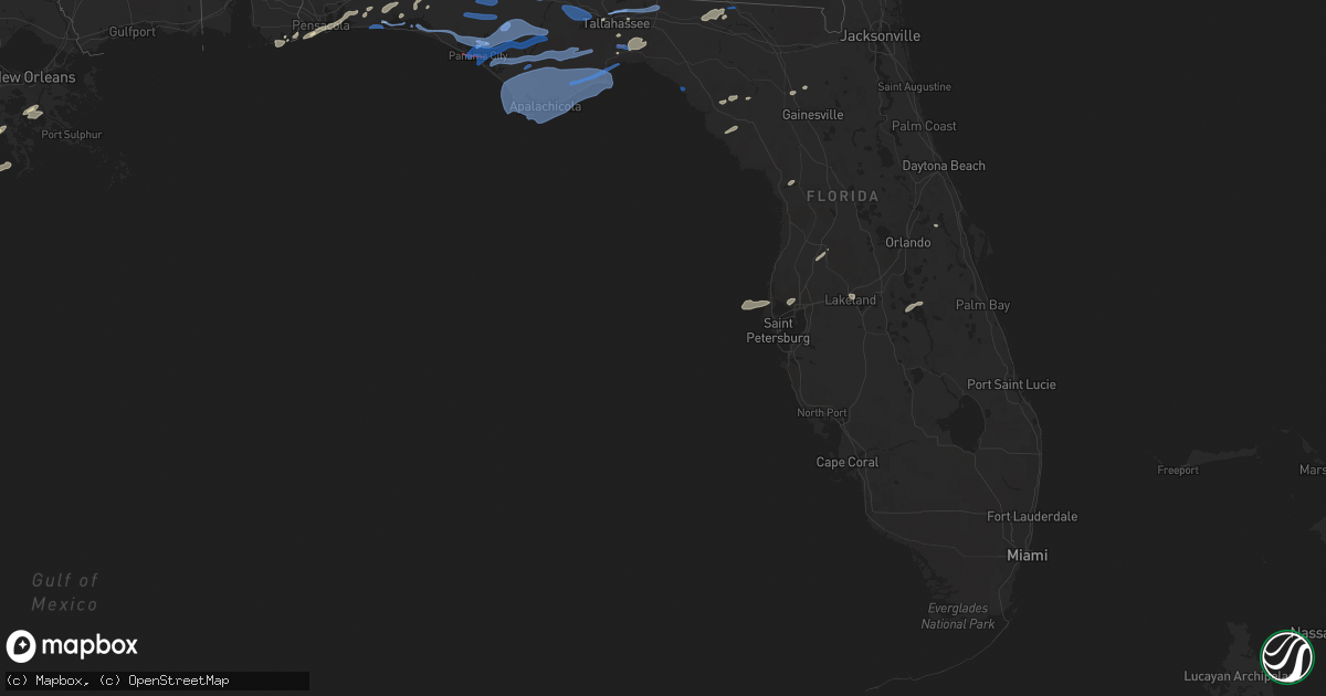
Hail Map in Florida on April 23, 2020
Get this storm
April 23 map
$229
one time, instant access
Download today. No call, no setup
Keep the $229
Bought the map and want the full workflow? Apply the entire $229 to a subscription within 7 days. None of it is wasted.
Every map, not just this one
This buys you this map. Subscription and you get every map we run, in the markets you choose from a few cities to whole states to nationwide. Plus real-time alerts the moment a storm fires.
Contact data
Name, contact info, occupancy, even credit band for addresses in the footprint. You go from where it hit to who to call.
Become the source they trust
Unlimited branding weather history reports on demand. You already have the documented answer ready for the property owner, and you are the one who showed up with it.
Property data and RoofTrace estimates
Pull up any address you have got, its value and the exact code rules for that jurisdiction, straight from One Click Code. Then RoofTrace estimates the squares, pitch, and roof value, priced the way you price.
Storm reports in Florida
Florida
| Date | Description |
|---|---|
| 04/23/20206:58 PM CDT | Tin roof damaged. Tornado possible. |
| 04/23/20206:56 PM CDT | Ef1 tornado based on storm survey. |
| 04/23/20206:53 PM CDT | Report of multiple trees down bringing down a powerline and causing a small fire and covering a roadway near the intersection of nw county road 152 and nw 13th drive. T |
| 04/23/20206:00 PM CDT | Tree blew down in a neighbors yard. |
| 04/23/20205:55 PM CDT | Tree down. |
| 04/23/20205:54 PM CDT | Ef1 tornado based on storm survey. |
| 04/23/20205:50 PM CDT | Several trees down throughout county. |
| 04/23/20205:50 PM CDT | Tree on house. |
| 04/23/20205:46 PM CDT | Trees and power lines on road. |
| 04/23/20205:46 PM CDT | Mesonet station prwf1 st. Marks. |
| 04/23/20205:45 PM CDT | Trees and powerlines down. |
| 04/23/20205:40 PM CDT | Multiple trees down with powerline entanglement. |
| 04/23/20205:38 PM CDT | This is the end point for an ef1 tornado. A tornado touched down just south of north monroe street and moved east into a neighborhood where there was widespread limb an |
| 04/23/20205:35 PM CDT | Trees down. |
| 04/23/20205:30 PM CDT | Trees on houses. |
| 04/23/20205:30 PM CDT | Tree in roadway. |
| 04/23/20205:25 PM CDT | Tree blocking road. |
| 04/23/20205:24 PM CDT | Tree limbs in the road. |
| 04/23/20205:24 PM CDT | Tree blocking roadway. |
| 04/23/20205:22 PM CDT | This is the start point for an ef1 tornado. A tornado touched down just south of north monroe street and moved east into a neighborhood where there was widespread limb |
| 04/23/20204:50 PM CDT | Tree down. |
| 04/23/20204:45 PM CDT | Tree down. |
| 04/23/20204:30 PM CDT | Trees down in mexico beach. |
| 04/23/20204:22 PM CDT | Tree down on power lines along highway 231 and east linger longer road. |
| 04/23/20204:18 PM CDT | Trees down in the bayou george area. |
| 04/23/20204:17 PM CDT | Trees down in callaway. |
| 04/23/20204:15 PM CDT | Several trees down across jackson county. |
| 04/23/20204:15 PM CDT | Measured gust of 69 mph at kpam. |
| 04/23/20204:15 PM CDT | Power lines down at 912 pitts ave. |
| 04/23/20204:15 PM CDT | A lot of the new landscaping trees from the median on tyndall pkwy were pulled out of the ground from cherry to north of highway 22. |
| 04/23/20204:13 PM CDT | Power line down at south deer haven and fawn road. |
| 04/23/20204:10 PM CDT | Multiple media and broadcast media reports of trees down... Potential damage to marina and a gym and other minor structural damage. |
| 04/23/20204:09 PM CDT | Video posted on social media showing a brief tornado from the backyard of a resident. |
| 04/23/20204:08 PM CDT | Tree fell on truck. |
| 04/23/20204:07 PM CDT | Ef2 tornado based on storm survey. |
| 04/23/20204:06 PM CDT | Tree and power lines down on magnolia beach road and west ave. |
| 04/23/20204:04 PM CDT | Tree down blocking the road at 2913 thomas drive. |
| 04/23/20204:00 PM CDT | Picture of structural damage from the cottondale area on social media. |
| 04/23/20204:00 PM CDT | Ef0 tornado based on storm survey. |
| 04/23/20203:49 PM CDT | Several trees down throughout washington county. |
| 04/23/20203:48 PM CDT | Ef0 tornado based on storm survey. |
| 04/23/20203:40 PM CDT | Several trees down in the bonifay area. |
| 04/23/20203:40 PM CDT | Several trees down throughout washington county. |
| 04/23/20203:30 PM CDT | Minor roof damage... Boat flipped and broken car windows...possible tornado. |
| 04/23/20203:20 PM CDT | Spotter estimated a 60mph gust. |
| 04/23/20203:13 PM CDT | Ef1 tornado based on storm survey. |
| 04/23/20203:12 PM CDT | Window and roof damage to 2 commercial buildings. Possible tornado. |
| 04/23/20202:52 PM CDT | Downed trees... Power lines... And shingle damage to homes in the ocean city-wright area. |
| 04/23/20202:51 PM CDT | A tornado touched down along vickie leigh road and quickly intensified to ef-1 strength. There was a path of numerous trees uprooted and snapped. Winds were estimated a |
| 04/23/20202:47 PM CDT | Khrt hurlburt field measured a 58 mph thunderstorm wind gust. |
| 04/23/20202:40 PM CDT | Several trees down across jackson county. |
| 04/23/20202:35 PM CDT | Downed tree on a house. |
| 04/23/202010:51 AM CDT | This the end point of the downburst that began just east of the choctawhatchee river along route 179 near izagora drive in izagora florida. The downburst affected an ar |
| 04/23/202010:35 AM CDT | This the start point of the downburst that ended near route 173 near steverson road... About 5.8 miles south of noma florida. The downburst affected an area around 13.4 |
| 04/23/202010:06 AM CDT | Report of several large trees down on hwy 2 between campbellton and malone. |
| 04/23/202010:00 AM CDT | Trees and power lines down on robins bridge road. |
| 04/23/202010:00 AM CDT | Trees and power lines down at wrights creek road and welding road. |
| 04/23/202010:00 AM CDT | Trees and power lines down at 1461 gavin road. |
| 04/23/202010:00 AM CDT | Trees and power lines down on ivy bush road. |
| 04/23/202010:00 AM CDT | Trees and power lines down at 1620 highway 173. |
| 04/23/202010:00 AM CDT | Trees and power lines down at elrod circle. |
| 04/23/202010:00 AM CDT | Trees and power lines down at malcom taylor road. |
| 04/23/202010:00 AM CDT | Trees and power lines down on phillips road off of highway 177. |
| 04/23/202010:00 AM CDT | Trees and power lines down along highway 173 near highway 160. |
| 04/23/202010:00 AM CDT | Trees and power lines down at monroe paul road. |
| 04/23/202010:00 AM CDT | Trees and power lines down along highway 173 at carmichael road. |
| 04/23/202010:00 AM CDT | Trees and power lines down at pinehill cutoff. |
| 04/23/202010:00 AM CDT | Trees and power lines down on will lee road just off of highway 177. |
| 04/23/202010:00 AM CDT | Trees and power lines down at triple lane and twin lakes drive. |
| 04/23/20209:40 AM CDT | Trees and debris on road at cr160 and fl 79. |
| 04/23/20208:51 AM CDT | Structural damage to a farm building. Report from social media. |
| 04/23/20207:20 AM CDT | At 1219 PM CDT, a severe thunderstorm was located 6 miles north of Navarre, or 9 miles southeast of Bagdad, moving northeast at 50 mph. HAZARD...60 mph wind gusts and quarter size hail. SOURCE...Radar indicated. IMPACT...Hail damage to vehicles is expected. Expect wind damage to roofs, siding, and trees. Locations impacted include... Crestview. |
| 04/23/20206:57 AM CDT | At 1157 AM CDT, a severe thunderstorm was located over Warrington, moving northeast at 55 mph. HAZARD...60 mph wind gusts and half dollar size hail. SOURCE...Radar indicated. IMPACT...Hail damage to vehicles is expected. Expect wind damage to roofs, siding, and trees. Locations impacted include... Pensacola, Brent, West Pensacola, Warrington, Gulf Breeze, Goulding, Myrtle Grove, Oriole Beach, Navarre, Navarre Beach and Pensacola Beach. |
| 04/23/20206:35 AM CDT | Usaf tower ksc-0108 measured wind gust of 59kt/68mph from the sw. |
| 04/23/20206:25 AM CDT | Usaf tower ksc-0403 measured wind gust of 54kt/62 mph from sw |
| 04/23/20205:27 AM CDT | At 1027 AM CDT, severe thunderstorms were located along a line extending from 12 miles east of Castleberry to 5 miles southeast of Jay, moving east at 35 mph. HAZARD...60 mph wind gusts. SOURCE...Radar indicated. IMPACT...Expect damage to roofs, siding, and trees. Locations impacted include... Andalusia, Opp, Florala, Laurel Hill and Lockhart. |
| 04/23/20205:12 AM CDT | Delayed report... Public relayed photos of a large uprooted tree in addition to damaged metal roof. Time estimated by radar. |
| 04/23/20205:11 AM CDT | At 1011 PM EDT, a severe thunderstorm was located near Raiford, moving northeast at 35 mph. HAZARD...60 mph wind gusts. SOURCE...Radar indicated. IMPACT...Expect damage to roofs, siding, and trees. Locations impacted include... Orange Park, Raiford, Macclenny, Glen St. Mary, Maxville, Cisco Gardens, Ortega, Oakleaf Plantation, Bellair-Meadowbrook Terrace and Bryceville. |
| 04/23/20205:04 AM CDT | One tree uprooted and a few large tree branches snapped falling onto a car causing damage on 50th st. N. And burlington ave. N. In st. Petersburg. Also... A tree snappe |
| 04/23/20204:00 AM CDT | A tree was blown down across 5800 old kings road in palm coast. The time of damage was based on radar. |
| 04/23/20203:26 AM CDT | At 826 PM EDT, severe thunderstorms were located along a line extending from 10 miles southeast of Homerville to 6 miles north of Belmont to 6 miles west of Luraville, moving east at 35 mph. HAZARD...60 mph wind gusts and penny size hail. SOURCE...Radar indicated. IMPACT...Expect damage to roofs, siding, and trees. Locations impacted include... Lake City, Live Oak, Jasper, Folkston, White Springs, Fargo, Stephen Foster State Park, Suwannee River State Park, Suwannee Springs and Columbia. |
| 04/23/20203:22 AM CDT | At 822 AM CDT, severe thunderstorms were located along a line extending from near Gantt to near River Falls to 17 miles east of East Brewton to 14 miles southeast of Riverview, moving east at 50 mph. HAZARD...60 mph wind gusts and half dollar size hail. SOURCE...Radar indicated. IMPACT...Hail damage to vehicles is expected. Expect wind damage to roofs, siding, and trees. Locations impacted include... Daleville, Elba, Geneva, Enterprise, Fort Rucker, Ozark, Hartford, Level Plains, Samson, Newton, New Brockton, Ariton, Pinckard, Lee, Union, Liberty, Paxton, Clayhatchee, Kinston and Coffee Springs. |
| 04/23/20203:12 AM CDT | At 812 AM CDT, severe thunderstorms were located along a line extending from near McKenzie to 16 miles east of East Brewton to 4 miles south of Jay, moving east at 45 mph. HAZARD...60 mph wind gusts and penny size hail. SOURCE...Radar indicated. IMPACT...Expect damage to roofs, siding, and trees. Locations impacted include... Andalusia, Opp, Florala, East Brewton, River Falls, Jay, Red Level, Laurel Hill, Lockhart, Dozier, Heath, Gantt and Riverview. |
| 04/23/20203:08 AM CDT | At 808 PM EDT, severe thunderstorms were located along a line extending from 11 miles south of Madison to 18 miles west of Steinhatchee, moving east at 30 mph. HAZARD...60 mph wind gusts. SOURCE...Radar indicated. IMPACT...Expect damage to roofs, siding, and trees. Locations impacted include... Mayo, Perry, Steinhatchee, Cross City, Lee, Pinland, Shamrock, Jug Island, Old Town, Foley, Perry-Foley Airport, San Pedro Junction, Boyd, Smith, Hopewell, Carbur, Adams Beach, Townsend, Bird Island and Eugene. |
| 04/23/20202:36 AM CDT | At 736 PM EDT, severe thunderstorms were located along a line extending from near Ray City to 16 miles west of Perry, moving east at 45 mph. HAZARD...60 mph wind gusts and quarter size hail. SOURCE...Radar indicated. IMPACT...Hail damage to vehicles is expected. Expect wind damage to roofs, siding, and trees. Locations impacted include... Live Oak, Jasper, Homerville, Jennings, Argyle, Statenville, Suwannee River State Park, Suwannee Springs, Du Pont and Mayday. |
| 04/23/20202:35 AM CDT | At 735 AM CDT, severe thunderstorms were located along a line extending from 5 miles east of I65 And AL 21 to 5 miles southwest of Atmore to 4 miles east of Bay Minette, moving east at 55 mph. HAZARD...60 mph wind gusts and penny size hail. SOURCE...Radar indicated. IMPACT...Expect damage to roofs, siding, and trees. Locations impacted include... Atmore, Brewton, Century, Flomaton, East Brewton, Jay, Pollard, Riverview, Bratt, I65 And CR 1, I65 And AL 21 and Poarch Creek Reservation. |
| 04/23/202012:50 AM CDT | Trees blew down onto power lines resulting in a power outage to 39 customers. |
| 04/23/202012:06 AM CDT | At 506 PM EDT/406 PM CDT/, severe thunderstorms were located along a line extending from near Columbia to near Marianna to 11 miles southwest of Panama City, moving east at 55 mph. HAZARD...60 mph wind gusts and quarter size hail. SOURCE...Radar indicated. IMPACT...Hail damage to vehicles is expected. Expect wind damage to roofs, siding, and trees. Locations impacted include... Panama City, Lynn Haven, Callaway, Colquitt, Cottonwood, Newton, Marianna, Bainbridge, Blakely, Blountstown, Donalsonville, Port St. Joe, Springfield, Ashford, Arlington, Mexico Beach, Columbia, Hiland Park, Stonemill Creek and Chattahoochee. |
| 04/22/202011:55 PM CDT | At 454 PM EDT/354 PM CDT/, severe thunderstorms were located along a line extending from 11 miles south of Vernon to near Panama City Beach to 26 miles southwest of Tyndall Air Force Base, moving east at 45 mph. HAZARD...70 mph wind gusts and quarter size hail. SOURCE...Radar indicated. IMPACT...Hail damage to vehicles is expected. Expect considerable tree damage. Wind damage is also likely to mobile homes, roofs, and outbuildings. Locations impacted include... Panama City, Lynn Haven, Panama City Beach, Callaway, Springfield, Mexico Beach, Hiland Park, Tyndall Air Force Base, Parker, St Andrews State Park, Allanton, Cedar Grove, Dirego Park, Beacon Beach, College Station, Gulf Resort Beach, Bayou George, Cape San Blas, West Panama City and Bahama Beach. |
| 04/22/202011:30 PM CDT | The top of a cherry tree fell on a power line and resulted in a power outage. |
| 04/22/202010:42 PM CDT | At 342 PM EDT/242 PM CDT/, severe thunderstorms were located along a line extending from near Colquitt to 7 miles southeast of Chipley, moving east at 40 mph. HAZARD...60 mph wind gusts and penny size hail. SOURCE...Radar indicated. IMPACT...Expect damage to roofs, siding, and trees. Locations impacted include... Colquitt, Bainbridge, Donalsonville, Marianna, Camilla, West Bainbridge, Chattahoochee, Bradford, Centerville, Malone, Sneads, Cottondale, Grand Ridge, Greenwood, Alford, Wausau, Gordon, Iron City, Brinson and Jakin. |
| 04/22/20209:50 PM CDT | At 249 PM CDT, severe thunderstorms were located along a line extending from near Laurel Hill to near Mary Esther, moving east at 50 mph. HAZARD...60 mph wind gusts and half dollar size hail. SOURCE...Radar indicated. IMPACT...Hail damage to vehicles is expected. Expect wind damage to roofs, siding, and trees. Locations impacted include... Vernon, Santa Rosa Beach, De Funiak Springs, Bonifay, Eglin Air Force Base, Union, Liberty, Live Oak, Freeport, Paxton, Ponce De Leon, Caryville, Esto, Westville, Ebro, Noma, Oakwood Hills, Cluster Springs, Whitehead Crossroads and Villa Tasso. |
| 04/22/20209:28 PM CDT | At 228 PM CDT, severe thunderstorms were located along a line extending from 11 miles southeast of Jay to 6 miles southeast of Roeville to 18 miles southeast of Pensacola Beach, moving east at 60 mph. HAZARD...60 mph wind gusts and quarter size hail. SOURCE...Radar indicated. IMPACT...Hail damage to vehicles is expected. Expect wind damage to roofs, siding, and trees. Locations impacted include... Wright, Fort Walton Beach, Crestview, Niceville, Destin, Eglin AFB, Valparaiso, Mary Esther, Ocean City, Lake Lorraine, Baker, Navarre, Shalimar, Laurel Hill, Cinco Bayou and Navarre Beach. |
| 04/22/20209:13 PM CDT | At 213 PM CDT, a severe thunderstorm was located 4 miles northeast of Oriole Beach, or 8 miles northeast of Gulf Breeze, moving east at 60 mph. HAZARD...60 mph wind gusts and quarter size hail. SOURCE...Radar indicated. IMPACT...Hail damage to vehicles is expected. Expect wind damage to roofs, siding, and trees. Locations impacted include... Pace, Milton, Gulf Breeze, Bagdad, Oriole Beach, Navarre, Navarre Beach, Pea Ridge, Roeville, Floridatown and Point Baker. |
| 04/22/20208:34 PM CDT | At 134 PM EDT, severe thunderstorms were located along a line extending from 7 miles northeast of Willacoochee to 6 miles north of Mayday, moving east at 50 mph. HAZARD...70 mph wind gusts and quarter size hail. SOURCE...Radar indicated. IMPACT...Hail damage to vehicles is expected. Expect considerable tree damage. Wind damage is also likely to mobile homes, roofs, and outbuildings. Locations impacted include... Waycross, Alma, Blackshear, Folkston, Nahunta, Patterson, Argyle, Stephen Foster State Park, Nicholls and Homeland. |
| 04/22/20208:11 PM CDT | Trained storm spotter reported a tornado observed moving east near us highway 129 about 3 miles north of bell. |
| 04/22/20208:06 PM CDT | Large oak tree fell on parsonage causing roof damage. Portion of church roof missing with siding torn off. Several large cedar trees snapped nearby. Potential tornado d |
| 04/22/20207:50 PM CDT | Trees and power lines down in the county. |
| 04/22/20207:30 PM CDT | Downed powerline caught tree on fire. |
| 04/22/20207:15 PM CDT | Tree down. |
Cities Impacted by Hail Map on April 23, 2020
- Flowery Branch, GA
- Buford, GA
- Oakwood, GA
- Gainesville, GA
- Centreville, AL
- Brent, AL
- Randolph, AL
- Eutaw, AL
- Boligee, AL
- Barataria, LA
- Lafitte, LA
- Homerville, GA
- Waycross, GA
- Blackshear, GA
- Nashville, GA
- Adel, GA
- Ray City, GA
- Porterville, MS
- Darien, GA
- Patterson, GA
- Manor, GA
- Hortense, GA
- Nahunta, GA
- Brunswick, GA
- Lakeland, GA
- Hoboken, GA
- Sapelo Island, GA
- Townsend, GA
- Old Town, FL
- Fort Walton Beach, FL
- Sweet Water, AL
- Lisman, AL
- Demopolis, AL
- Pennington, AL
- Linden, AL
- Jachin, AL
- Butler, AL
- Ward, AL
- York, AL
- Elberta, AL
- Jasper, FL
- Addis, LA
- Grosse Tete, LA
- Baton Rouge, LA
- Port Allen, LA
- Plaquemine, LA
- Brusly, LA
- Tallahassee, FL
- Lamont, FL
- Monticello, FL
- Crawfordville, FL
- Woodbine, GA
- Dade City, FL
- White Oak, GA
- Folkston, GA
- Jekyll Island, GA
- Waverly, GA
- Dulac, LA
- Tampa, FL
- Pearson, GA
- Moundville, AL
- Jemison, AL
- Marion, AL
- Sawyerville, AL
- Lawley, AL
- Greensboro, AL
- Akron, AL
- Pensacola, FL
- Gulf Breeze, FL
- Shalimar, FL
- Larose, LA
- Chauvin, LA
- Lockport, LA
- Montegut, LA
- Theriot, LA
- Houma, LA
- Cut Off, LA
- Saint Marys, GA
- Geneva, FL
- Lynn Haven, FL
- Panama City, FL
- Emelle, AL
- Epes, AL
- De Kalb, MS
- Amite, LA
- Orange Beach, AL
- Waynesville, GA
- Axson, GA
- Millwood, GA
- Willacoochee, GA
- Newbern, AL
- Screven, GA
- Jesup, GA
- Columbia, MS
- Sumrall, MS
- Oak Vale, MS
- Bassfield, MS
- Carson, MS
- Defuniak Springs, FL
- Quitman, GA
- Denham Springs, LA
- Gulf Shores, AL
- Greensburg, LA
- Pachuta, MS
- Paulding, MS
- Stonewall, MS
- Meridian, MS
- Rose Hill, MS
- Enterprise, MS
- Quitman, MS
- Roseland, LA
- Saint Simons Island, GA
- Brooker, FL
- Alachua, FL
- Horseshoe Beach, FL
- Lake Wales, FL
- Kenansville, FL
- High Springs, FL
- Sardis, AL
- Orrville, AL
- Dunnellon, FL
- Inglis, FL
- Lakeland, FL
- Eglin Afb, FL
- Daleville, MS
- Watonga, OK
- Greenfield, OK
- Clearwater, FL
- Clearwater Beach, FL
- Dunedin, FL
- Belle Chasse, LA
- Cumming, GA
- Calumet, OK
- Geary, OK
- Madison, FL
- Lee, FL
- Pinetta, FL
- Jennings, FL
- Niceville, FL
- Meigs, GA
- Pansey, AL
- Whigham, GA
- Coolidge, GA
- Hahira, GA
- Donalsonville, GA
- Pelham, GA
- Cairo, GA
- Morven, GA
- Damascus, GA
- Gordon, AL
- Camilla, GA
- Iron City, GA
- Ochlocknee, GA
- Jakin, GA
- Blakely, GA
- Cowarts, AL
- Webb, AL
- Colquitt, GA
- Brinson, GA
- Dothan, AL
- Bainbridge, GA
- Newton, GA
- Thomasville, GA
- Boston, GA
- Ashford, AL
- Pavo, GA
- Climax, GA
- Moultrie, GA
- Slocomb, AL
- Barney, GA
- Newton, AL
- Berlin, GA
- Hartford, AL
- Columbia, AL
- Argyle, GA
- Ellenton, GA
- Valdosta, GA
- Hartsfield, GA
- Sparks, GA
- Norman Park, GA
- Sea Island, GA
- Fargo, GA
- Gillsville, GA
- Suwanee, GA
- Alpharetta, GA
- Lula, GA
- Laurel Hill, FL
- Jay, FL
- Creola, AL
- Geneva, AL
- McDavid, FL
- Baker, FL
- Campbellton, FL
- Lockhart, AL
- Flomaton, AL
- Stockton, AL
- Andalusia, AL
- Bonifay, FL
- Florala, AL
- Kinston, AL
- Milton, FL
- Century, FL
- Graceville, FL
- Greenwood, FL
- Brewton, AL
- Westville, FL
- Ponce De Leon, FL
- Wing, AL
- Marianna, FL
- Bay Minette, AL
- Samson, AL
- Atmore, AL
- Perdido, AL
- Cottondale, FL
- Opp, AL
- Red Level, AL
- New Brockton, AL
- Elba, AL
- Chancellor, AL
- Enterprise, AL
- Mary Esther, FL
- Hurlburt Field, FL
- Chipley, FL
- Alford, FL
- Caryville, FL
- Grand Ridge, FL
- Santa Rosa Beach, FL
- Miramar Beach, FL
- Panama City Beach, FL
- Blountstown, FL
- Bristol, FL
- Fountain, FL
- Altha, FL
- Clarksville, FL
- Youngstown, FL
- Wewahitchka, FL
- Vernon, FL
- Ebro, FL
- Greensboro, FL
- Quincy, FL
- Sopchoppy, FL
- Hosford, FL
- Apalachicola, FL
- Eastpoint, FL
- Port Saint Joe, FL
- Panacea, FL
- Lanark Village, FL
- Carrabelle, FL
- Perry, FL


