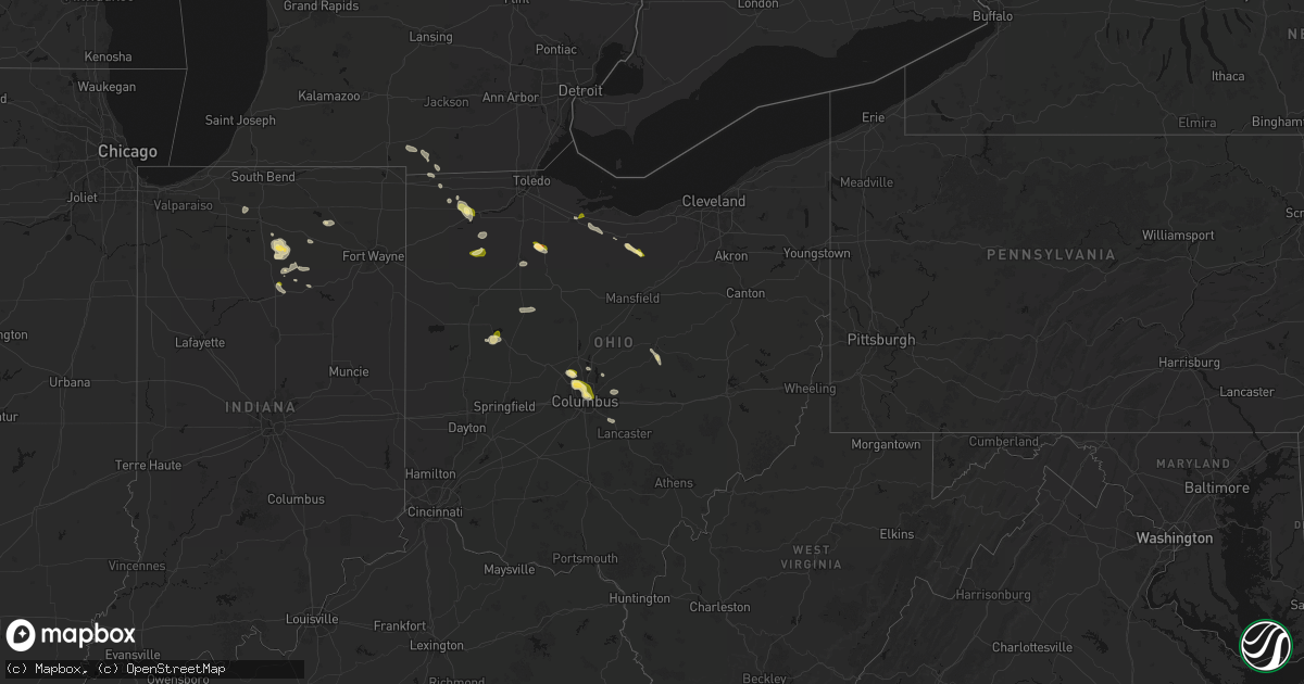
Hail Map in Ohio on April 22, 2026
Get this storm
April 22 map
$229
one time, instant access
Download today. No call, no setup
Keep the $229
Bought the map and want the full workflow? Apply the entire $229 to a subscription within 7 days. None of it is wasted.
Every map, not just this one
This buys you this map. Subscription and you get every map we run, in the markets you choose from a few cities to whole states to nationwide. Plus real-time alerts the moment a storm fires.
Contact data
Name, contact info, occupancy, even credit band for addresses in the footprint. You go from where it hit to who to call.
Become the source they trust
Unlimited branding weather history reports on demand. You already have the documented answer ready for the property owner, and you are the one who showed up with it.
Property data and RoofTrace estimates
Pull up any address you have got, its value and the exact code rules for that jurisdiction, straight from One Click Code. Then RoofTrace estimates the squares, pitch, and roof value, priced the way you price.
Storm reports in Ohio
Ohio
| Date | Description |
|---|---|
| 04/22/20265:10 PM CDT | Hail covering ground. Max hailstone diameter is 1 inch. |
| 04/22/20265:09 PM CDT | A local report indicates 1.00 inch wind near Fostoria |
| 04/22/20265:09 PM CDT | Delayed report - ping pong size hail. |
| 04/22/20264:50 PM CDT | Delayed report. Quarter size hail reported between leipsic and ottawa. Time estimated via radar. |
| 04/22/20264:45 PM CDT | Delayed report. Dime to quarter size hail reported between leipsic and miller city on sr 613. Time estimated via radar. |
| 04/22/20264:42 PM CDT | Mping report. |
| 04/22/20264:41 PM CDT | A local report indicates 1.00 inch wind near 1 NW Minerva Park |
| 04/22/20264:37 PM CDT | A local report indicates 1.00 inch wind near 3 E Miller City |
| 04/22/20264:35 PM CDT | Delayed report. Time estimated via radar. |
| 04/22/20264:35 PM CDT | Quarter size hail reported at the intersection of cr 613 and road 12 se of miller city. Time estimated via radar. |
| 04/22/20264:10 PM CDT | Photos show 1.3 inch hail. |
| 04/22/20264:07 PM CDT | Photos show several 1 inch hail stones. |
| 04/22/20264:07 PM CDT | Average hail size .375 inches. |
| 04/22/20264:06 PM CDT | Range of hail sizes... Largest stones nickel to quarter sized. |
All States Impacted by Hail Map on April 22, 2026
Cities Impacted by Hail Map on April 22, 2026
- Cherokee, IA
- Dolliver, IA
- Walkerton, IN
- Plymouth, IN
- Hillsdale, MI
- Reading, MI
- Quincy, MI
- Allen, MI
- North Webster, IN
- Argos, IN
- Tippecanoe, IN
- Rochester, IN
- Cromwell, IN
- Kimmell, IN
- Pierceton, IN
- Larwill, IN
- Bourbon, IN
- Mentone, IN
- Albion, IN
- Osseo, MI
- Pittsford, MI
- Akron, IN
- Claypool, IN
- Hudson, MI
- Waldron, MI
- Macy, IN
- Silver Lake, IN
- North Manchester, IN
- Alvordton, OH
- Pioneer, OH
- Camden, MI
- Roann, IN
- Warsaw, IN
- Laketon, IN
- West Unity, OH
- Boling, TX
- Damon, TX
- Wabash, IN
- Archbold, OH
- Guy, TX
- Peru, IN
- Wauseon, OH
- Napoleon, OH
- Plain City, OH
- Delaware, OH
- Powell, OH
- Dublin, OH
- Denver, IN
- Ridgeville Corners, OH
- Defiance, OH
- Columbus, OH
- Stryker, OH
- Hilliard, OH
- Hamler, OH
- Pataskala, OH
- Morenci, MI
- Fayette, OH
- Deshler, OH
- Miller City, OH
- Ottawa, OH
- Leipsic, OH
- Continental, OH
- Fremont, OH
- Galena, OH
- Westerville, OH
- Vickery, OH
- Clyde, OH
- Fort Stockton, TX
- Lewistown, OH
- Bloomdale, OH
- Garwood, TX
- Fostoria, OH
- Lakeview, OH
- Russells Point, OH
- Bellevue, OH
- Navasota, TX
- Huntsville, OH
- Belle Center, OH
- De Graff, OH
- College Station, TX
- Hallettsville, TX
- Kenton, OH
- Anderson, TX
- Gambier, OH
- Walhonding, OH
- Howard, OH
- Louise, TX
- Frazeysburg, OH
- Monroeville, OH
- Edna, TX
- Norwalk, OH
- Carroll, OH
- New London, OH
- Sycamore, OH
- Nevada, OH
- Bucyrus, OH
- North Fairfield, OH
- Bedias, TX
- Ganado, TX
- Findlay, OH
- Belvidere, SD
- Poplar, MT
- Okaton, SD
- Gonzales, TX
- Cost, TX
- Murdo, SD
- Gettysburg, SD
- Selby, SD
- Hoven, SD
- Merriman, NE
- Fort Pierre, SD
- Onida, SD
- Pierre, SD
- Orient, SD
- Lebanon, SD
- Rockham, SD
- Tolstoy, SD
- Onaka, SD
- Richville, MN
- Alvada, OH


