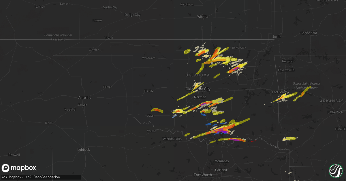
Hail Map in Oklahoma on April 22, 2020
Get this storm
April 22 map
$229
one time, instant access
Download today. No call, no setup
Keep the $229
Bought the map and want the full workflow? Apply the entire $229 to a subscription within 7 days. None of it is wasted.
Every map, not just this one
This buys you this map. Subscription and you get every map we run, in the markets you choose from a few cities to whole states to nationwide. Plus real-time alerts the moment a storm fires.
Contact data
Name, contact info, occupancy, even credit band for addresses in the footprint. You go from where it hit to who to call.
Become the source they trust
Unlimited branding weather history reports on demand. You already have the documented answer ready for the property owner, and you are the one who showed up with it.
Property data and RoofTrace estimates
Pull up any address you have got, its value and the exact code rules for that jurisdiction, straight from One Click Code. Then RoofTrace estimates the squares, pitch, and roof value, priced the way you price.
Storm reports in Oklahoma
Oklahoma
| Date | Description |
|---|---|
| 04/22/20205:53 PM CDT | A damaging tornado was reported southeast of caddo. |
| 04/22/20205:32 PM CDT | A tornado developed near the atoka-coal county line about 7 miles southwest of lehigh and moved east dissipating approximately 559 pm south or south-southwest of lehigh |
| 04/22/20205:32 PM CDT | A large tornado developed west-northwest of armstrong and moved east passing north and northeast of armstrong to at least 538 pm. Homes were damaged in the lake durant |
| 04/22/20205:26 PM CDT | A tornado developed south of bromide and moved east passing near or north of wapanucka. |
| 04/22/20205:15 PM CDT | Baseball size hail in nida... Ok at 77 and 22. |
| 04/22/20205:12 PM CDT | A tornado was reported near little city. |
| 04/22/20205:08 PM CDT | Mping. |
| 04/22/20204:53 PM CDT | *** 1 fatal *** a damaging tornado moved through madill... Damaging numerous homes... Businesses and industrial buildings. The tornado continued to approximately 505 pm |
| 04/22/20204:51 PM CDT | A brief tornado developed about 4 miles southwest of madill. |
| 04/22/20204:24 PM CDT | A large tornado developed northeast of springer and moved east-northeast... Likely moving into murray county near dougherty. The tornado lasted until approximately 437 |
| 04/22/20204:23 PM CDT | A local report indicates a tornado near 1 NE SPRINGER |
| 04/22/20204:20 PM CDT | Semi-trailer on side at i35 & mm66. |
| 04/22/20204:17 PM CDT | A local report indicates a tornado near 7 SW PAULS VALLEY |
| 04/22/20203:47 PM CDT | A local report indicates 1.00 inch wind near 4 S RUSH SPRINGS |
| 04/22/20203:17 PM CDT | Ping pong size hail at bird creek rd... 3 miles south on hwy 77. |
| 04/22/20203:14 PM CDT | Mping report. |
| 04/22/20203:12 PM CDT | A local report indicates 1.50 inch wind near 2 E ELGIN |
| 04/22/20203:11 PM CDT | Mping report. |
| 04/22/20203:09 PM CDT | Mping report. |
| 04/22/20203:03 PM CDT | Mping report. 1-inch tree limbs broken; shingles blown off. |
| 04/22/20202:09 PM CDT | Social media relayed by media |
| 04/22/20201:21 PM CDT | A local report indicates 1.00 inch wind near HILLSDALE |
| 04/22/202012:40 PM CDT | A local report indicates 1.00 inch wind near 1 SE CLEVELAND |
| 04/22/202012:19 PM CDT | A local report indicates 1.00 inch wind near 3 NW LAKE ALUMA |
| 04/22/202012:04 PM CDT | A local report indicates 1.50 inch wind near 3.87 NW OKLAHOMA CITY |
| 04/22/202011:55 AM CDT | Twitter report. 23rd and portland. |
| 04/22/202011:55 AM CDT | I-40 and rockwell. Twitter report. |
| 04/22/202011:45 AM CDT | Sw 15th and morgan rd. |
| 04/22/202010:37 AM CDT | Em relayed in nwschat. |
| 04/22/202010:20 AM CDT | A local report indicates 2.50 inch wind near 2 SW RUSSETT |
| 04/22/202010:20 AM CDT | A local report indicates 1.00 inch wind near MANNSVILLE |
| 04/22/20209:20 AM CDT | A local report indicates 1.00 inch wind near NINNEKAH |
| 04/22/20208:50 AM CDT | Half dollar hail at 4300 w edison |
| 04/22/20208:49 AM CDT | Quarter to ping pong ball hail 9th and detroit |
| 04/22/20208:46 AM CDT | Half dollar hail downtown tulsa |
| 04/22/20208:45 AM CDT | Occurred in downtown tulsa. |
| 04/22/20208:43 AM CDT | Quarter size hail lasted 3 minutes at 29th and peoria in tulsa. |
| 04/22/20208:40 AM CDT | Ping pont ball hail at 81st west and hwy 412 |
| 04/22/20208:38 AM CDT | Ping pong to golf ball size hail in and around prattville |
| 04/22/20208:31 AM CDT | At 41st and 33rd |
| 04/22/20208:20 AM CDT | A local report indicates 1.00 inch wind near CLEVELAND |
| 04/22/20207:44 AM CDT | At 1244 AM CDT, a severe thunderstorm was located near Bray, moving east at 30 mph. HAZARD...Ping pong ball size hail and 60 mph wind gusts. SOURCE...Radar indicated. IMPACT...People and animals outdoors will be injured. Expect hail damage to roofs, siding, windows, and vehicles. Expect wind damage to roofs, siding, and trees. Locations impacted include... Duncan, Marlow, Bray, Foster, Pernell and Cox City. |
| 04/22/20207:33 AM CDT | At 1233 AM CDT, a severe thunderstorm was located over eastern Fort Sill, moving southeast at 25 mph. HAZARD...Golf ball size hail and 60 mph wind gusts. SOURCE...Radar indicated. IMPACT...People and animals outdoors will be injured. Expect hail damage to roofs, siding, windows, and vehicles. Expect wind damage to roofs, siding, and trees. Locations impacted include... Eastern Lawton, Duncan, Marlow, Bray, Velma, southeastern Fort Sill and Central High. |
| 04/22/20207:26 AM CDT | At 1225 AM CDT, a severe thunderstorm was located near Tatums, moving southeast at 40 mph. HAZARD...Two inch hail and 70 mph wind gusts. SOURCE...Radar indicated. IMPACT...People and animals outdoors will be injured. Expect hail damage to roofs, siding, windows, and vehicles. Expect considerable tree damage. Wind damage is also likely to mobile homes, roofs, and outbuildings. Locations impacted include... Ardmore, Sulphur, Davis, Lone Grove, Dickson, Springer, Elmore City, Velma, Katie, Dougherty, Foster, Gene Autry, Tatums, Ratliff City, Hickory, Graham, Pooleville, Lake Of The Arbuckles, Turner Falls and Hennepin. |
| 04/22/20207:14 AM CDT | At 1213 AM CDT, severe thunderstorms were located along a line extending from 8 miles south of Sterling to 4 miles northwest of Duncan to 3 miles north of Comanche, moving northeast at 40 mph. HAZARD...Ping pong ball size hail and 60 mph wind gusts. SOURCE...Radar indicated. IMPACT...People and animals outdoors will be injured. Expect hail damage to roofs, siding, windows, and vehicles. Expect wind damage to roofs, siding, and trees. Locations impacted include... Duncan, Marlow, Rush Springs, Bray, Central High and Cox City. |
| 04/22/20207:13 AM CDT | At 1213 PM CDT, a severe thunderstorm was located near Clayton, moving northeast at 55 mph. HAZARD...60 mph wind gusts and half dollar size hail. SOURCE...Radar indicated. IMPACT...Hail damage to vehicles is expected. Expect wind damage to roofs, siding, and trees. Locations in or near the path include... Clayton... Talihina... Red Oak... Albion... Clayton Lake State Park... Talimena State Park... Bengal... Tuskahoma... Yanush... Stanley... Kiamichi... Whitesboro... Sardis... |
| 04/22/20207:10 AM CDT | A local report indicates 1.50 inch wind near PAWNEE |
| 04/22/20207:04 AM CDT | At 1203 AM CDT, a severe thunderstorm was located 9 miles east of Leedey, moving east at 35 mph. HAZARD...Ping pong ball size hail and 60 mph wind gusts. SOURCE...Radar indicated. IMPACT...People and animals outdoors will be injured. Expect hail damage to roofs, siding, windows, and vehicles. Expect wind damage to roofs, siding, and trees. Locations impacted include... Oakwood and Putnam. |
| 04/22/20207:03 AM CDT | At 1203 PM CDT, a severe thunderstorm was located over northern Oklahoma City, or near Lake Aluma, moving northeast at 50 mph. HAZARD...Golf ball size hail and 60 mph wind gusts. SOURCE...Radar indicated. IMPACT...People and animals outdoors will be injured. Expect hail damage to roofs, siding, windows, and vehicles. Expect wind damage to roofs, siding, and trees. Locations impacted include... Northeastern Oklahoma City, Edmond, Midwest City, The Village, Spencer, Nichols Hills, Jones, Luther, Wellston, Carney, Tryon, Agra, Arcadia, Warwick, Meridian, Fallis, Forest Park, Lake Aluma and Parkland. |
| 04/22/20206:45 AM CDT | At 1144 AM CDT, a severe thunderstorm was located 4 miles west of Stidham, moving northeast at 45 mph. HAZARD...60 mph wind gusts and quarter size hail. SOURCE...Radar indicated. IMPACT...Hail damage to vehicles is expected. Expect wind damage to roofs, siding, and trees. Locations in or near the path include... Checotah... Rentiesville... Stidham... Lake Eufaula State Park... Pierce... Onapa...This includes Interstate 40 in Oklahoma between mile markers 255 and269. |
| 04/22/20206:38 AM CDT | At 1137 AM CDT, a severe thunderstorm was located 5 miles southwest of Daisy, moving northeast at 45 mph. HAZARD...Ping pong ball size hail and 60 mph wind gusts. SOURCE...Radar indicated. IMPACT...People and animals outdoors will be injured. Expect hail damage to roofs, siding, windows, and vehicles. Expect wind damage to roofs, siding, and trees. Locations in or near the path include... Clayton... Hartshorne... Clayton Lake State Park... Snow... Higgins... Stanley... Moyers... Kosoma... Dunbar... Blanco... Cloudy... Haileyville... Pittsburg... Eubanks... Sardis... Gowen... Finley... |
| 04/22/20206:27 AM CDT | At 1125 AM CDT, severe thunderstorms were located along a line extending from 6 miles south of Wardville to 8 miles northeast of Lane, moving northeast at 55 mph. HAZARD...Ping pong ball size hail and 60 mph wind gusts. SOURCE...Radar indicated. IMPACT...People and animals outdoors will be injured. Expect hail damage to roofs, siding, windows, and vehicles. Expect wind damage to roofs, siding, and trees. Locations impacted include... Atoka, Stringtown, Tushka, Lane, Daisy, Atoka Reservoir, McGee Creek Lake, Redden and Chockie. |
| 04/22/20206:08 AM CDT | At 1108 AM CDT, severe thunderstorms were located along a line extending from near Wetumka to 3 miles southeast of Holdenville, moving east at 45 mph. HAZARD...Ping pong ball size hail and 60 mph wind gusts. SOURCE...Radar indicated. IMPACT...People and animals outdoors will be injured. Expect hail damage to roofs, siding, windows, and vehicles. Expect wind damage to roofs, siding, and trees. Locations impacted include... Holdenville, Wetumka, Dustin, Lamar, Horntown, Yeager and Spaulding. |
| 04/22/20205:41 AM CDT | At 1041 AM CDT, a severe thunderstorm was located near Milburn, moving east-northeast at 45 mph. HAZARD...Tennis ball size hail and 60 mph wind gusts. SOURCE...Radar indicated. IMPACT...People and animals outdoors will be injured. Expect hail damage to roofs, siding, windows, and vehicles. Expect wind damage to roofs, siding, and trees. Locations impacted include... Atoka, Tishomingo, Coalgate, Wapanucka, Stringtown, Lehigh, Milburn, Tushka, Caney, Kenefic, Lane, Olney, Fillmore, Coleman, Nida, northeastern Lake Texoma, Phillips, Atoka Reservoir, Chockie and Bentley. |
| 04/22/20205:24 AM CDT | At 1023 AM CDT, a severe thunderstorm was located near Maud, moving east at 55 mph. HAZARD...Ping pong ball size hail and 60 mph wind gusts. SOURCE...Radar indicated. IMPACT...People and animals outdoors will be injured. Expect hail damage to roofs, siding, windows, and vehicles. Expect wind damage to roofs, siding, and trees. Locations impacted include... Seminole, Holdenville, Wewoka, Konawa, Wetumka, Maud, Bowlegs, Dustin, Cromwell, Lamar, St. Louis, Horntown, Yeager, Spaulding, Lima and Harjo. |
| 04/22/20205:02 AM CDT | At 1002 AM CDT, a severe thunderstorm was located 4 miles southwest of Dickson, moving northeast at 55 mph. HAZARD...Ping pong ball size hail and 60 mph wind gusts. SOURCE...Radar indicated. IMPACT...People and animals outdoors will be injured. Expect hail damage to roofs, siding, windows, and vehicles. Expect wind damage to roofs, siding, and trees. Locations impacted include... Ardmore, Madill, Tishomingo, Lone Grove, Dickson, Mannsville, Ravia, Wapanucka, Milburn, Bromide, Gene Autry, Overbrook, Fillmore, Reagan, Lake Murray, Connerville, Russett, Coleman, Nida and Pontotoc. |
| 04/22/20204:39 AM CDT | At 938 AM CDT, a severe thunderstorm was located near Purcell, moving northeast at 35 mph. Another strong storm was located near Dibble that may become severe. HAZARD...Ping pong ball size hail and 60 mph wind gusts. SOURCE...Radar indicated. IMPACT...People and animals outdoors will be injured. Expect hail damage to roofs, siding, windows, and vehicles. Expect wind damage to roofs, siding, and trees. Locations impacted include... Southeastern Norman, Purcell, Noble, Slaughterville, Lexington, Pink, Goldsby, Dibble, Wayne, Washington, Cole, Asher, Tribbey, Wanette, St. Louis, Etowah, Brooksville, Macomb, Criner and Lake Thunderbird. |
| 04/22/20204:22 AM CDT | At 921 PM CDT, severe thunderstorms were located along a line extending from near Horatio to Winthrop to near Arkinda, moving east at 40 mph. HAZARD...70 mph wind gusts and quarter size hail. SOURCE...Radar indicated. IMPACT...Hail damage to vehicles is expected. Expect considerable tree damage. Wind damage is also likely to mobile homes, roofs, and outbuildings. Locations impacted include... Ashdown, Nashville, Mineral Springs, Foreman, Lockesburg, Wilton, Blevins, Tollette, Fulton, Winthrop, Washington, Ben Lomond, Saratoga, Oak Grove, McCaskill, Ozan, McNab, Oakhaven, Bright Star and Silver Ridge. |
| 04/22/20204:21 AM CDT | At 920 AM CDT, a severe thunderstorm was located near Agra, moving northeast at 60 mph. HAZARD...60 mph wind gusts and quarter size hail. SOURCE...Radar indicated. IMPACT...Hail damage to vehicles is expected. Expect wind damage to roofs, siding, and trees. Locations impacted include... Cushing, Tryon, Agra, Kendrick, Avery and Parkland. |
| 04/22/20204:00 AM CDT | At 900 AM CDT, a severe thunderstorm was located 7 miles east of Rush Springs, moving northeast at 35 mph. HAZARD...Ping pong ball size hail and 60 mph wind gusts. SOURCE...Radar indicated. IMPACT...People and animals outdoors will be injured. Expect hail damage to roofs, siding, windows, and vehicles. Expect wind damage to roofs, siding, and trees. Locations impacted include... Purcell, Lindsay, Maysville, Rush Springs, Dibble, Wayne, Washington, Cole, Alex, Bradley, Criner, Payne, Cox City and Erin Springs. |
| 04/22/20203:19 AM CDT | At 819 AM CDT, a severe thunderstorm was located 4 miles southwest of Indiahoma, moving northeast at 55 mph. HAZARD...Ping pong ball size hail and 60 mph wind gusts. SOURCE...Radar indicated. IMPACT...People and animals outdoors will be injured. Expect hail damage to roofs, siding, windows, and vehicles. Expect wind damage to roofs, siding, and trees. Locations impacted include... Northwestern Lawton, Cache, Elgin, Fletcher, Sterling, Medicine Park, Indiahoma, Fort Sill, Meers, Lake Ellsworth, Lake Lawtonka and Wichita Mountains Wildlife Refuge. |
| 04/22/20202:58 AM CDT | At 757 AM CDT, a severe thunderstorm was located near Gracemont, moving northeast at 50 mph. HAZARD...60 mph wind gusts and quarter size hail. SOURCE...Radar indicated. IMPACT...Hail damage to vehicles is expected. Expect wind damage to roofs, siding, and trees. Locations impacted include... Southwestern Oklahoma City, Anadarko, Yukon, Mustang, Tuttle, Union City, Minco, Amber, Bridge Creek, Gracemont, Pocasset and Lake Chickasha. |
| 04/22/20202:40 AM CDT | At 738 PM CDT, severe thunderstorms were located along a line extending from 9 miles southwest of Goodland to 10 miles northwest of Paris to near Dodd City, moving east at 45 mph. HAZARD...70 mph wind gusts and ping pong ball size hail. SOURCE...Radar indicated. IMPACT...People and animals outdoors will be injured. Expect hail damage to roofs, siding, windows, and vehicles. Expect considerable tree damage. Wind damage is also likely to mobile homes, roofs, and outbuildings. Locations impacted include... Paris, Powderly, Honey Grove, Blossom, Dodd City, Roxton, Windom, Toco and Sun Valley. |
| 04/22/20201:39 AM CDT | At 638 PM CDT, a severe thunderstorm was located 11 miles southwest of Goodland, or 13 miles northwest of Paris, moving east at 30 mph. HAZARD...Two inch hail and 70 mph wind gusts. SOURCE...Radar indicated. IMPACT...People and animals outdoors will be injured. Expect hail damage to roofs, siding, windows, and vehicles. Expect considerable tree damage. Wind damage is also likely to mobile homes, roofs, and outbuildings. Locations impacted include... Arthur City...Belk...Garretts Bluff...Forest Chapel...Powderly... Midcity. |
| 04/22/20201:23 AM CDT | At 623 AM CDT, a severe thunderstorm was located 4 miles northeast of Perry, moving northeast at 40 mph. Another severe storm was located near Glencoe. HAZARD...Golf ball size hail and 60 mph wind gusts. SOURCE...Radar indicated. IMPACT...People and animals outdoors will be injured. Expect hail damage to roofs, siding, windows, and vehicles. Expect wind damage to roofs, siding, and trees. Locations impacted include... Stillwater, Ponca City, Perry, Morrison, Glencoe, Red Rock, Marland and Sooner Lake. |
| 04/22/20201:11 AM CDT | At 611 PM CDT, a severe thunderstorm was located near Lehigh, moving east at 55 mph. HAZARD...60 mph wind gusts and quarter size hail. SOURCE...Radar indicated. IMPACT...Hail damage to vehicles is expected. Expect wind damage to roofs, siding, and trees. Locations impacted include... Atoka, Stringtown, Lehigh, Daisy, Atoka Reservoir, Redden and McGee Creek Lake. |
| 04/22/202012:52 AM CDT | At 552 AM CDT, severe thunderstorms were located along a line extending from 5 miles west of Woodward to 6 miles southwest of Quinlan, moving northeast at 40 mph. HAZARD...60 mph wind gusts and quarter size hail. SOURCE...Radar indicated. IMPACT...Hail damage to vehicles is expected. Expect wind damage to roofs, siding, and trees. Locations impacted include... Woodward, Mooreland, Waynoka, Freedom, Alabaster Caverns State Park, Avard, Quinlan, Tangier, Hopeton, Bouse Junction and Camp Houston. |
| 04/22/202012:23 AM CDT | At 523 PM CDT, a severe thunderstorm was located 7 miles southwest of Allen, moving east at 45 mph. HAZARD...60 mph wind gusts and quarter size hail. SOURCE...Radar indicated. IMPACT...Hail damage to vehicles is expected. Expect wind damage to roofs, siding, and trees. Locations impacted include... Allen, Stuart and Gerty. |
| 04/22/202012:09 AM CDT | At 509 AM CDT, severe thunderstorms were located along a line extending from 6 miles west of Sharon to 7 miles southeast of Harmon, moving northeast at 40 mph. HAZARD...60 mph wind gusts and quarter size hail. SOURCE...Radar indicated. IMPACT...Hail damage to vehicles is expected. Expect wind damage to roofs, siding, and trees. Locations impacted include... Woodward, Mooreland, Vici, Sharon, Mutual, Quinlan and Cestos. |
| 04/22/202012:03 AM CDT | At 503 AM CDT, a severe thunderstorm was located 4 miles east of Ames, moving northeast at 40 mph. HAZARD...Ping pong ball size hail and 60 mph wind gusts. SOURCE...Radar indicated. IMPACT...People and animals outdoors will be injured. Expect hail damage to roofs, siding, windows, and vehicles. Expect wind damage to roofs, siding, and trees. Locations impacted include... Enid, Waukomis, Garber, Lahoma, Covington, Drummond, Kremlin, Breckenridge, Ames, Fairmont, Carrier, Douglas, Vance Air Force Base, Bison and North Enid. |
| 04/22/202012:02 AM CDT | At 501 AM CDT, a severe thunderstorm was located 12 miles southeast of Wolf Creek Park, or 13 miles northwest of Canadian, moving northeast at 40 mph. HAZARD...Quarter size hail. SOURCE...Radar indicated. IMPACT...Damage to vehicles is expected. Locations impacted include... Lipscomb, Higgins and Glazier. |
| 04/21/202011:53 PM CDT | At 453 AM CDT, severe thunderstorms were located along a line extending from 3 miles west of Avard to near Dacoma to 5 miles northwest of Helena, moving northeast at 35 mph. HAZARD...Ping pong ball size hail and 60 mph wind gusts. SOURCE...Radar indicated. IMPACT...People and animals outdoors will be injured. Expect hail damage to roofs, siding, windows, and vehicles. Expect wind damage to roofs, siding, and trees. Locations impacted include... Alva, Cherokee, Medford, Carmen, Wakita, Jet, Nash, Burlington, Dacoma, Amorita, Byron, Lambert, Avard, Ingersoll, Great Salt Plains Lake, Driftwood, Capron and Hopeton. |
| 04/21/202011:51 PM CDT | At 450 PM CDT, a severe thunderstorm was located 4 miles northeast of Mill Creek, moving east-northeast at 30 mph. HAZARD...Golf ball size hail and 70 mph wind gusts. SOURCE...Radar indicated. IMPACT...People and animals outdoors will be injured. Expect hail damage to roofs, siding, windows, and vehicles. Expect considerable tree damage. Wind damage is also likely to mobile homes, roofs, and outbuildings. Locations impacted include... Tupelo, Mill Creek, Bromide, Centrahoma, Connerville, Pontotoc, Clarita, Olney and Jesse. |
| 04/21/202011:34 PM CDT | At 434 AM CDT, a severe thunderstorm was located 5 miles southeast of Higgins, moving northeast at 40 mph. Another severe storm was located 5 miles northeast of Durham. HAZARD...60 mph wind gusts and quarter size hail. SOURCE...Radar indicated. IMPACT...Hail damage to vehicles is expected. Expect wind damage to roofs, siding, and trees. Locations impacted include... Woodward, Shattuck, Arnett, Gage, Fargo, Harmon and Tangier. |
| 04/21/202011:13 PM CDT | At 413 PM CDT, a severe thunderstorm was located over southern Lake Murray, moving east at 40 mph. HAZARD...70 mph wind gusts and quarter size hail. SOURCE...Radar indicated. IMPACT...Hail damage to vehicles is expected. Expect considerable tree damage. Wind damage is also likely to mobile homes, roofs, and outbuildings. Locations impacted include... Ardmore, Madill, Tishomingo, Kingston, Mannsville, Russett, Overbrook, Little City, Lake Murray, northeastern Lake Texoma and Oakland. |
| 04/21/202010:47 PM CDT | At 346 PM CDT, a severe thunderstorm was located over Milo, moving east at 40 mph. HAZARD...70 mph wind gusts and penny size hail. SOURCE...Radar indicated. IMPACT...Expect considerable tree damage. Damage is likely to mobile homes, roofs, and outbuildings. Locations impacted include... Springer, Dougherty, Gene Autry, Milo, Lake Of The Arbuckles and Turner Falls. |
| 04/21/202010:38 PM CDT | At 338 PM CDT, a severe thunderstorm was located near Marlow, moving east at 45 mph. HAZARD...Ping pong ball size hail and 60 mph wind gusts. SOURCE...Radar indicated. IMPACT...People and animals outdoors will be injured. Expect hail damage to roofs, siding, windows, and vehicles. Expect wind damage to roofs, siding, and trees. Locations impacted include... Pauls Valley, Marlow, Maysville, Rush Springs, Bray, Elmore City, Paoli, Katie, Foster, Antioch, Acme, Cox City, Whitebead and Erin Springs. |
| 04/21/202010:12 PM CDT | At 311 AM CDT, a severe thunderstorm was located 4 miles northwest of Little City, moving east at 45 mph. HAZARD...60 mph wind gusts and quarter size hail. SOURCE...Radar indicated. IMPACT...Hail damage to vehicles is expected. Expect wind damage to roofs, siding, and trees. Locations impacted include... Durant, Madill, Kingston, Caddo, Bokchito, Silo, Kenefic, Mead, Armstrong, Blue, Utica, Little City, Nida, northeastern Lake Texoma, Calera and Oakland. |
| 04/21/20209:59 PM CDT | At 259 PM CDT, a severe thunderstorm was located 4 miles southwest of Lake Ellsworth, moving east at 40 mph. HAZARD...60 mph wind gusts and quarter size hail. SOURCE...Radar indicated. IMPACT...Hail damage to vehicles is expected. Expect wind damage to roofs, siding, and trees. Locations impacted include... Elgin, Rush Springs, Fletcher, Sterling, Medicine Park, Lake Ellsworth, Agawam, Lake Lawtonka, eastern Fort Sill and Acme. |
| 04/21/20209:57 PM CDT | At 257 AM CDT, a severe thunderstorm was located near Caney, moving east at 45 mph. Another severe thunderstorm was exiting far eastern Atoka County. HAZARD...60 mph wind gusts and quarter size hail. SOURCE...Radar indicated. IMPACT...Hail damage to vehicles is expected. Expect wind damage to roofs, siding, and trees. Locations impacted include... Tushka, Caney, Lane, Bentley, Darwin and southern McGee Creek Lake. |
| 04/21/20209:53 PM CDT | At 253 PM CDT, a severe thunderstorm was located 4 miles northeast of Billings, moving east at 40 mph. HAZARD...Quarter size hail. SOURCE...Radar indicated. IMPACT...Damage to vehicles is expected. Locations impacted include... Ponca City, Tonkawa, Billings, Marland and southwestern Kaw Lake. |
| 04/21/20209:34 PM CDT | At 234 AM CDT, a severe thunderstorm was located near Ardmore, moving east at 45 mph. HAZARD...Golf ball size hail and 60 mph wind gusts. SOURCE...Radar indicated. IMPACT...People and animals outdoors will be injured. Expect hail damage to roofs, siding, windows, and vehicles. Expect wind damage to roofs, siding, and trees. Locations impacted include... Ardmore, Madill, Tishomingo, Lone Grove, Kingston, Dickson, Mannsville, Springer, Ravia, Gene Autry, Russett, Little City, northern Lake Murray, northeastern Lake Texoma and Oakland. |
| 04/21/20209:33 PM CDT | At 232 AM CDT, a severe thunderstorm was located 6 miles southeast of Caney, moving east at 35 mph. HAZARD...Golf ball size hail and 60 mph wind gusts. SOURCE...Radar indicated. IMPACT...People and animals outdoors will be injured. Expect hail damage to roofs, siding, windows, and vehicles. Expect wind damage to roofs, siding, and trees. Locations in or near the path include... Hugo... Antlers... Boswell... Soper... Kent... Moyers... Kellond... Darwin... Speer... Dela... Unger... Finley... |
| 04/21/20209:24 PM CDT | At 224 AM CDT, severe thunderstorms were located along a line extending from near Wapanucka to near Fillmore to near Tishomingo, moving east at 40 mph. HAZARD...60 mph wind gusts and quarter size hail. SOURCE...Radar indicated. IMPACT...Hail damage to vehicles is expected. Expect wind damage to roofs, siding, and trees. Locations impacted include... Atoka, Tishomingo, Caddo, Wapanucka, Milburn, Tushka, Caney, Kenefic, Bromide, Lane, Fillmore, Coleman, Nida, northern Lake Texoma, Bentley, McGee Creek Lake and Boggy Depot Park. |
| 04/21/20209:09 PM CDT | At 209 PM CDT, a severe thunderstorm was located near Mountain Park, moving east at 40 mph. Another developing storm which could become severe was located 5 miles west of Snyder. HAZARD...Ping pong ball size hail and 60 mph wind gusts. SOURCE...Radar indicated. IMPACT...People and animals outdoors will be injured. Expect hail damage to roofs, siding, windows, and vehicles. Expect wind damage to roofs, siding, and trees. Locations impacted include... Lawton, Cache, Snyder, Mountain Park, Medicine Park, Indiahoma, Fort Sill, Meers, Tom Steed Reservoir, Lake Ellsworth, Lake Lawtonka and Wichita Mountains Wildlife Refuge. |
| 04/21/20209:00 PM CDT | At 200 AM CDT, severe thunderstorms were located along a line extending from 5 miles south of Wynnewood to 4 miles east of Pooleville to 4 miles southeast of Loco, moving southeast at 25 mph. HAZARD...Golf ball size hail and 60 mph wind gusts. SOURCE...Radar indicated. IMPACT...People and animals outdoors will be injured. Expect hail damage to roofs, siding, windows, and vehicles. Expect wind damage to roofs, siding, and trees. Locations impacted include... Ardmore, Sulphur, Davis, Lone Grove, Healdton, Wynnewood, Wilson, Springer, Dougherty, Gene Autry, Tatums, Ratliff City, Hickory, Graham, Pooleville, Lake Of The Arbuckles, Turner Falls, Hennepin, Milo and Fox. |
| 04/21/20208:50 PM CDT | At 149 AM CDT, a large severe thunderstorm was centered near Milburn, moving east-southeast at 40 mph. This is a very dangerous storm. HAZARD...Baseball size hail and 70 mph wind gusts. SOURCE...Radar indicated. IMPACT...People and animals outdoors will be severely injured. Expect shattered windows, extensive damage to roofs, siding, and vehicles. Locations impacted include... Tishomingo, Caddo, Bokchito, Bennington, Milburn, Tushka, Caney, Kenefic, Lane, Fillmore, Coleman, Nida, northern Lake Texoma, Bentley, Boggy Depot Park, Darwin and southern McGee Creek Lake. |
| 04/21/20208:31 PM CDT | At 131 PM CDT, a severe thunderstorm was located near Warren, moving east at 20 mph. HAZARD...60 mph wind gusts and quarter size hail. SOURCE...Radar indicated. IMPACT...Hail damage to vehicles is expected. Expect wind damage to roofs, siding, and trees. Locations impacted include... Blair, Mountain Park, Roosevelt, Warren and Tom Steed Reservoir. |
| 04/21/20208:26 PM CDT | At 125 AM CDT, a severe thunderstorm was located 4 miles east of Duncan, moving east at 25 mph. HAZARD...Two inch hail and 60 mph wind gusts. SOURCE...Radar indicated. IMPACT...People and animals outdoors will be injured. Expect hail damage to roofs, siding, windows, and vehicles. Expect wind damage to roofs, siding, and trees. Locations impacted include... Duncan, Healdton, Velma, Tatums, Loco, Ratliff City and Fox. |
| 04/21/20208:10 PM CDT | At 110 AM CDT, a severe thunderstorm was located near Dougherty, moving east-southeast at 40 mph. This is a very dangerous storm. HAZARD...Baseball size hail and 70 mph wind gusts. SOURCE...Radar indicated. IMPACT...People and animals outdoors will be severely injured. Expect shattered windows, extensive damage to roofs, siding, and vehicles. Locations impacted include... Tishomingo, Ravia, Mill Creek, Milburn, Bromide, Fillmore, Reagan, Lake Of The Arbuckles and northern Lake Texoma. |
All States Impacted by Hail Map on April 22, 2020
Cities Impacted by Hail Map on April 22, 2020
- Provencal, LA
- Barnsdall, OK
- Fort Smith, AR
- Mill Creek, OK
- Hackett, AR
- Hominy, OK
- Pawnee, OK
- Fairfax, OK
- Mannsville, OK
- Ardmore, OK
- Caddo, OK
- Tishomingo, OK
- Coleman, OK
- Madill, OK
- Kenefic, OK
- Durant, OK
- Milburn, OK
- Pocasset, OK
- Leesville, LA
- Burkeville, TX
- Deridder, LA
- Colmesneil, TX
- Jasper, TX
- Newton, TX
- Wiergate, TX
- Brookeland, TX
- Evans, LA
- Anacoco, LA
- Wesson, MS
- Fort Necessity, LA
- Gilbert, LA
- Wisner, LA
- Winnsboro, LA
- Converse, LA
- Noble, LA
- Hemphill, TX
- Belmont, LA
- Lamont, OK
- Hunter, OK
- Medford, OK
- Deer Creek, OK
- Ralston, OK
- Paris, AR
- Pond Creek, OK
- Claremore, OK
- Greenwood, AR
- Lavaca, AR
- Cameron, OK
- Charleston, AR
- Huntington, AR
- Red Rock, OK
- Perry, OK
- Billings, OK
- Marland, OK
- Booneville, AR
- Cushing, TX
- Douglass, TX
- Pocola, OK
- Grapeland, TX
- Elkhart, TX
- Hazlehurst, MS
- Tulsa, OK
- Sand Springs, OK
- Nash, OK
- Morrison, OK
- Marlow, OK
- Saint Martinville, LA
- Atoka, OK
- Nacogdoches, TX
- Chireno, TX
- Mineral Springs, AR
- Nashville, AR
- Erwinville, LA
- Lakeland, LA
- Oscar, LA
- Livonia, LA
- Port Allen, LA
- Maringouin, LA
- Lottie, LA
- Fordoche, LA
- Albany, LA
- Independence, LA
- Wynona, OK
- Pawhuska, OK
- Shidler, OK
- Ponca City, OK
- Cleveland, OK
- Osage, OK
- Burbank, OK
- Waukomis, OK
- Garber, OK
- Blackwell, OK
- Mustang, OK
- Inverness, MS
- Leland, MS
- Greenwood, MS
- Greenville, MS
- Isola, MS
- Schlater, MS
- Indianola, MS
- Moorhead, MS
- Hollandale, MS
- Sunflower, MS
- Monona, IA
- Harpers Ferry, IA
- Eastman, WI
- Wauzeka, WI
- Prairie Du Chien, WI
- Waterville, IA
- Pitkin, LA
- Covington, OK
- Natchitoches, LA
- Robeline, LA
- Huntsville, TX
- Groveton, TX
- Trinity, TX
- Bokchito, OK
- Dodson, LA
- Alto, TX
- Coushatta, LA
- Sulphur, OK
- Sikes, LA
- Many, LA
- Montgomery, LA
- Atlanta, LA
- Chester, TX
- Shreveport, LA
- Byars, OK
- Owasso, OK
- Catoosa, OK
- Newellton, LA
- Pattison, MS
- Lorman, MS
- Magee, MS
- Silver Creek, MS
- Prentiss, MS
- Monticello, MS
- Newhebron, MS
- Pinola, MS
- Mendenhall, MS
- Mount Olive, MS
- Broken Arrow, OK
- Hendrix, OK
- Calera, OK
- Skiatook, OK
- Oklahoma City, OK
- Denham Springs, LA
- Rusk, TX
- Georgetown, MS
- Prue, OK
- Yukon, OK
- Tonkawa, OK
- Florien, LA
- Edmond, OK
- Bethany, OK
- Sapulpa, OK
- Elgin, OK
- Lawton, OK
- Kellyville, OK
- Bristow, OK
- Mannford, OK
- Itta Bena, MS
- Pleasant Hill, LA
- Jonesboro, LA
- Saline, LA
- Castor, LA
- Bienville, LA
- Ashland, LA
- Wapanucka, OK
- Holden, LA
- Walker, LA
- Corrigan, TX
- Konawa, OK
- Oakwood, TX
- Jarreau, LA
- Krotz Springs, LA
- Melville, LA
- Port Gibson, MS
- Palestine, TX
- Mansfield, AR
- Ada, OK
- Hermanville, MS
- Iowa, LA
- Kinder, LA
- Lake Charles, LA
- Vidalia, LA
- Jenks, OK
- Bixby, OK
- Stonewall, OK
- Bennington, OK
- Rush Springs, OK
- Austin, TX
- Mounds, OK
- Hineston, LA
- Marthaville, LA
- Campti, LA
- Goldonna, LA
- San Augustine, TX
- Lexington, OK
- Zwolle, LA
- Columbia, LA
- Bossier City, LA
- Singer, LA
- Jefferson, TX
- Vivian, LA
- Elton, LA
- Pauls Valley, OK
- Maysville, OK
- Allen, OK
- Barksdale Afb, LA
- Moscow, TX
- Glenpool, OK
- Overbrook, OK
- Caney, OK
- Nocona, TX
- Nardin, OK
- Anadarko, OK
- Sperry, OK
- Lane, OK
- Stringtown, OK
- Sicily Island, LA
- Arcadia, OK
- Wilson, OK
- Horatio, AR
- Ozan, AR
- Lockesburg, AR
- Hornbeck, LA
- Collinsville, OK
- Kennard, TX
- Ninnekah, OK
- Glencoe, OK
- Poteau, OK
- Fletcher, OK
- Opelousas, LA
- Stratford, OK
- Iota, LA
- Chickasha, OK
- Port Barre, LA
- Greenwell Springs, LA
- Baton Rouge, LA
- Arnaudville, LA
- Baker, LA
- Winnfield, LA
- Eunice, LA
- Church Point, LA
- Magazine, AR
- Livingston, TX
- Maramec, OK
- Scranton, AR
- Stillwater, OK
- Apache, OK
- Jones, OK
- Ratcliff, AR
- Branch, AR
- Lindsay, OK
- Subiaco, AR
- Jennings, OK
- Roosevelt, OK
- Haskell, OK
- Chunchula, AL
- Saint Joseph, LA
- Fort Polk, LA
- Wells, TX
- Monterey, LA
- Alex, OK
- Waukon, IA
- Luana, IA
- Drummond, OK
- Natchez, LA
- Citronelle, AL
- Crockett, TX
- Oologah, OK
- Sulphur, LA
- Vinton, LA
- Midway, TX
- Prescott, AR
- Lucedale, MS
- Wister, OK
- Minco, OK
- McCaskill, AR
- Kiefer, OK
- Wanette, OK
- Center, TX
- Ventress, LA
- Rougon, LA
- Rosedale, LA
- Zachary, LA
- Pointblank, TX
- Ryan, OK
- Mansfield, LA
- Rudy, AR
- Van Buren, AR
- New Roads, LA
- Asher, OK
- Braman, OK
- Round Rock, TX
- Terlton, OK
- Lufkin, TX
- Red Oak, OK
- Paoli, OK
- Fort Sill, OK
- Natchez, MS
- Fayette, MS
- Cyril, OK
- Fitzhugh, OK
- Roff, OK
- Basile, LA
- Sumner, TX
- Boswell, OK
- Arthur City, TX
- Lecompte, LA
- Postville, IA
- Castalia, IA
- Midland, AR
- Hartford, AR
- Center Point, LA
- Alexandria, LA
- Effie, LA
- Pineville, LA
- Jonesville, LA
- Deville, LA
- Marksville, LA
- Alva, OK
- Helena, OK
- Lovelady, TX
- Pollok, TX
- Shelbyville, TX
- Purcell, OK
- Pride, LA
- Telephone, TX
- Sontag, MS
- Alma, AR
- Longville, LA
- Colbert, OK
- Westlake, LA
- Collins, MS
- Onalaska, TX
- Foreman, AR
- Wewoka, OK
- Bradley, OK
- Bowlegs, OK
- Maud, OK
- Wayne, OK
- Macomb, OK
- Seminole, OK
- Milam, TX
- Gordonville, TX
- Whitesboro, TX
- Gainesville, TX
- Woodville, TX
- Bedias, TX
- Oakhurst, TX
- Woodworth, LA
- Elmer, LA
- Glenmora, LA
- Acme, LA
- Buffalo, TX
- Centerville, TX
- Paris, TX
- Powderly, TX
- Bunkie, LA
- Wynnewood, OK
- Elmore City, OK
- Davis, OK
- Springer, OK
- Taylorsville, MS
- Axis, AL
- Saraland, AL
- Wilmer, AL
- Raymond, MS
- Edwards, MS
- Bolton, MS
- Clinton, MS
- Utica, MS
- Florence, MS
- Pearl, MS
- Terry, MS
- Brandon, MS
- Crystal Springs, MS
- Flowood, MS
- Pulaski, MS
- Raleigh, MS
- Newton, MS
- Hickory, MS
- Morton, MS
- Enterprise, MS
- Forest, MS
- Louin, MS
- Pelahatchie, MS
- Chunky, MS
- Meridian, MS
- Lawrence, MS
- Lake, MS
- Heidelberg, MS
- Laurel, MS
- Mccomb, MS
- Smithdale, MS
- Summit, MS
- Foxworth, MS
- Sieper, LA
- Jennings, LA
- Welsh, LA
- Mulhall, OK
- Orlando, OK
- Crescent, OK
- Guthrie, OK
- Gracemont, OK
- Tuttle, OK
- Wheatland, OK
- Henrietta, TX
- Cement, OK
- Agra, OK
- Tryon, OK
- Stroud, OK
- Cushing, OK
- Chandler, OK
- Lone Grove, OK
- Burneyville, OK
- Ringling, OK
- Marietta, OK
- Holdenville, OK
- Wetumka, OK
- Antlers, OK
- Clayton, OK
- Kremlin, OK
- Enid, OK
- Lone Wolf, OK
- Mountain Park, OK
- Mangum, OK
- Blair, OK
- Pottsboro, TX
- Kingston, OK
- Denison, TX
- Cartwright, OK
- Tupelo, OK
- Coalgate, OK
- Ozark, AR
- New Blaine, AR
- Clarksville, AR
- Dover, AR
- Hagarville, AR
- Lamar, AR


